Housing on the Slope: Difference between revisions
| Line 105: | Line 105: | ||
</gallery> | </gallery> | ||
</td><td> | </td><td> | ||
<gallery caption=" " widths="535px" heights=" | <gallery caption=" " widths="535px" heights="455px" perrow="1"> | ||
Image:Karakter.jpg|*Coherent character | Image:Karakter.jpg|*Coherent character | ||
</gallery> | </gallery> | ||
Revision as of 21:33, 21 December 2011
---> back to overview of Case Study List
Housing on the slope of Banovo brdo
| Name | Housing on the slope of Banovo brdo | |
| Location | Belgrade | |
| Country | Serbia | |
| Authors | Danijela Lalović, Aleksandra Obrenović, Marko Ivošević, Slobodan Mančić | |

| ||
| <googlemap version="0.9" lat="44.77428" lon="20.418262" type="satellite" zoom="14" width="300" height="300">
44.802416, 20.465601, Belgrade Belgrade Belgrade, Central Serbia 44.775377, 20.41852, Banovo brdo Housing on the slope of Banovo brdo, Čukarica, Belgrade </googlemap> | ||
Short Introduction to the Area of Study
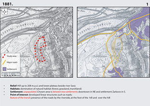
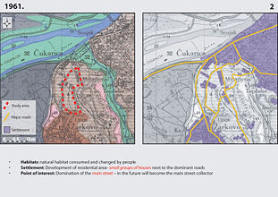
The study area is located in S-W part of Belgrade, approximately 6,5km (≈4 miles) from the center. It is a part of one of the Belgrade’s hills – Banovo brdo, and includes W and N-W hillsides with total size around 1,3km2 (≈0,5 square mile). Height distance (altitude) between the highest and the lowest spot on the slope is 70 meters. Because of the specific form of relief, direction of the streets is parallel to contour lines. Steep streets, that extend perpendicular to contours, give long-distance sights. Residential area is mainly consisted of opened and semi-opened urban blocks of medium density, local park, green market and central traffic and pedestrian spine – Pozeska Street. Because it represents community collector, Pozeska Street includes some administrative, commercial and other urban functions. Neighborhood collectors and local streets contain small, private, commercial facilities. Taking into account the value of the neighboring zones (River island Ada from North, farming fields on West and park-forest Kosutnjak on East) and peaceful, almost uniformly residential part concentrated around crowded and lively Pozeska street, it is clear that this area is probably one of a kind in Belgrade. Its specific context, relief, urban structure and presence of many utilities, provides that this area and people in it operate almost apart from rest of the city. Therefore, it would be challenge to assess and improve this unusual everyday landscape.
-
 *Context (Location of the Area)
 -
 *Context (Location of the Area)
 -
 *Study Area


Exercise 1: Sketching the Landscape
Time frame: October 25 - November 15, 2011
Sketches and Drawings
|


|
|


Exercise 2: Landscape Layers
Time frame: November 15 - 29, 2011
Landscape biography
- Importance of choosing the “Landscape biography” method: Neighboring zones had the biggest influence on development of the study area. Historical circumstances caused the urban growth; relief and environment had been natural framework for constellation of the settlement
-
 *Layer-Cake
 -
 *Layer1
 -
 *Layer2
 -
 *Layer3
 -
 *Layer4
 -
 *Layer5


Landscape analysis - introduction study for Behavior Patterns and Assessment of coherent character
|
|


Exercise 3: Behaviour Patterns
Time frame: December 6 - 20, 2011
Characteristic behaviour patterns
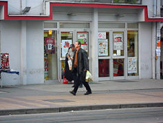
- Pozeska Street is the biggest point of interest in the study area, includes the main function spots (administration, education, shopping, entertainment…)
- Higher usage intensity of collector and trough steep streets that lead to collector; local streets along the contour lines with lower level of movement
- Local “Integrated” streets are spontaneously formed, according to lack of public spaces
- Local movement uphill by public transport, downhill mainly by walk; circulation from other parts of town to hill by public transport
Surprising behaviour patterns
- Lack of children’s playgrounds – they exist in Park and in open block with new multistory buildings (SW of the area)
- Local streets often used as children’s playground (integrated street)
- Modern construction provides intimate micro ambient, but they are rarely used
Correspondence of space and behaviour
- Small physical capacity of area; people have adapted to these conditions
- The main nonconformity: lack of parking space
- Streets at a greater distance from the Pozeska Street are still peaceful with low intensity of movement
|
|


-
 *Bus stop – toward to Center
 -
 *Vehicular and Pedestrian traffic
 -
 *Weekend parking problem
 -
 *Shopping mall in Pozeska
 -
 *Street vendors in Pozeska
 -
 *Grocery and supermarkets
 -
 *Fast food shops in Pozeska
 -
 *Coffee shop on the Slope
 -
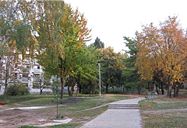
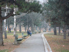 *Park on the Slope – visited even in cold weather
 -
 *Children’s playground in Park
 -
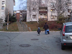 *Streets on the Slope – safe for children’s play
 -
 *Difficulty walking uphill – particularly for elders


Please publish your findings here
Exercise 4: Communication Concepts
Time frame: December 19, 2011 - January 17, 2012
- Based on the different landscape assessment approaches students will develop a communication concept for their area of study
- Which measures would be necessary for enhancing the awareness for the area?
- Students are free to choose their method.
-
your image text
-
your image text
-
your image text
-
your image text
-
your image text
Please publish your findings here
Image Gallery
-
 *Individual and collective housing
 -
 *Individual and collective housing
 -
 *Individual and collective housing
 -
 *Small private stores (business)
 -
 *Small private stores (business)
 -
 *Integrated streets
 -
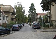 *Integrated streets
 -
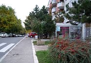
 *Pozeska Street
 -
 *Pozeska Street
 -
 *Visual sights
 -
 *Specific ambient
 -
 *Specific ambient
 -
 *Specific ambient
 -
 *Specific ambient


References
* Please make sure that you give proper references of all external resources used.
* Do not use images of which you do not hold the copyright.
* Please add internet links to other resources if necessary.
About categories: You can add more categories with this tag: "", add your categories