Rheinpark: Difference between revisions
No edit summary |
|||
| Line 75: | Line 75: | ||
* Observation of study area, interviews with local people and mapping of use patterns. | * Observation of study area, interviews with local people and mapping of use patterns. | ||
* Preparation of short presentation | * Preparation of short presentation | ||
<gallery caption=" " widths="150px" heights="150px" perrow="5"> | |||
Image:yourimagename.jpg|your image text | |||
Image:yourimagename.jpg|your image text | |||
Image:yourimagename.jpg|your image text | |||
Image:yourimagename.jpg|your image text | |||
Image:yourimagename.jpg|your image text | |||
</gallery> | |||
''Please publish your findings here'' | ''Please publish your findings here'' | ||
Revision as of 15:41, 12 December 2011
---> back to overview of Case Study List
Rheinpark I Duisburg I Germany
| Name | Rheinpark | |
| Location | Duisburg | |
| Country | Germany | |
| Authors | Hendrik Haußmann | |

| ||
| <googlemap version="0.9" lat="51.408669" lon="6.748137" zoom="16" width="300" height="250" controls="small">
</googlemap> | ||
Short Introduction to the Area of Study
The park is in the south of Duisburg near the district Hochfeld. It’s an old area of a metal factory. Loidel and TOPOS landscape architects tried to open the place near the river. They developed an area of modern employments, living space, culture and leisure time.
The area is about 25 ha. and was finished in the year 2009. The architects decided to include the old buildings of the factory in their concept. To make the ruins more attractive for the visitors, the planners commissioned some graffiti artists to create a special concept for the buildings. Near these old colorful ruins is the “skate area”, which is very good accepted by young people.
Also the bridge form the main part to the river is an impressive building; it offers the visitor a great view over the park and the other side of the Rhein.
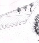
Exercise 1: Sketching the Landscape
Time frame: October 25 - November 15, 2011
Student activities:
- Creation of analytical drawings and sketches
- Presentation of results
Please upload a selection of your drawings/sketches/mental maps and add them to the image gallery
Sketches and Drawings
-
 overview
 -
 main_area
 -
 river_ area
 -
 platform
 -
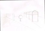 ruins
ruins


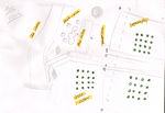
Exercise 2: Landscape Layers
Time frame: November 15 - 29, 2011
- time based changes and 'landscape biography', and/or:
- topography, open spaces, built, green, traffic and water structures on different layers. *Definition of zones with coherent character
- Description of this character.
-
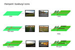 the park with icons
 -
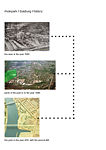 the history
 -
your image text
-
your image text
-
your image text

Please publish your findings here
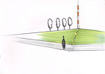
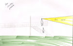
Exercise 3: Behaviour Patterns
Time frame: December 6 - 20, 2011
- How do people behave in this area? How do they use the space? What is important for them?
- Observation of study area, interviews with local people and mapping of use patterns.
- Preparation of short presentation
-
your image text
-
your image text
-
your image text
-
your image text
-
your image text
Please publish your findings here
Exercise 4: Communication Concepts
Time frame: December 19, 2011 - January 17, 2012
- Based on the different landscape assessment approaches students will develop a communication concept for their area of study
- Which measures would be necessary for enhancing the awareness for the area?
- Students are free to choose their method.
Please publish your findings here
Image Gallery
-
your image text
-
your image text
-
your image text
-
your image text
-
your image text
References
* Please make sure that you give proper references of all external resources used.
* Do not use images of which you do not hold the copyright.
* Please add internet links to other resources if necessary.
About categories: You can add more categories with this tag: "", add your categories