River Area Frankfurt Main: Difference between revisions
| Line 86: | Line 86: | ||
Image:725px-Frankfurt_Am_Main-Freie_Stadt_Frankfurt-Plan-1845.jpg|The plan shows the information published under the Superintendence of the Society for the Diffusion of Useful Knowledge | Image:725px-Frankfurt_Am_Main-Freie_Stadt_Frankfurt-Plan-1845.jpg|The plan shows the information published under the Superintendence of the Society for the Diffusion of Useful Knowledge, show the Frankfurt green belt where the ancient wall was once built, and demolished in the 19th Century and grassed over | ||
Image:Errere.jpg|The work of Julius Eduard Foltz-Eberle published in 1852 has been the most famous map of the city until the publication of the plan by Ravenstein in 1862. | Image:Errere.jpg|The work of Julius Eduard Foltz-Eberle published in 1852 has been the most famous map of the city until the publication of the plan by Ravenstein in 1862. | ||
| Line 97: | Line 97: | ||
Image:Mk_Frankfurt_Merian_Katharinenpforte.jpg|St. Catherine's Gate, Frankfurt am Main. The church on top right is St. Catherine's, the square on top left is Hauptwache square in central Frankfurt. The gate was bulit in late 12th century and demolished 600 years later | Image:Mk_Frankfurt_Merian_Katharinenpforte.jpg|St. Catherine's Gate, Frankfurt am Main. The church on top right is St. Catherine's, the square on top left is Hauptwache square in central Frankfurt. The gate was bulit in late 12th century and demolished 600 years later | ||
Image:800px-Gallustor,_Frankfurt_(Merian).png| | |||
Image:800px-Gallustor,_Frankfurt_(Merian).png|Medieval city walls, in the early 19th Century were demolished and grassed over.Thus, in the heart of the city from the former defensive wall is well worth seeing green belt. | |||
Image:800px-Frankfurt_Judengasse_1628.jpg|Frankfurt am Main, Germany: This part shows the Judengasse (jewish ghetto) and the monastery of the dominican order. | Image:800px-Frankfurt_Judengasse_1628.jpg|Frankfurt am Main, Germany: This part shows the Judengasse (jewish ghetto) and the monastery of the dominican order. | ||
Image:800px-Frankfurt_Judengasse_1628.jpg|The building, as well as the adjacent tower to the three Sauköpfen are clearly visible. East of the aisle is the Arnsburger yard to look at their southern end of the bridge tower in Frankfurt. | |||
'''Frankfurt History 1880- present''' | '''Frankfurt History 1880- present''' | ||
Revision as of 14:09, 5 December 2011
---> back to overview of Case Study List
add long title of your theme
| Name | Frankfurt am Main River Area | |
| Location | Frankfurt am Main | |
| Country | Germany | |
| Authors | S. Pio Brown Staikidis | |

| ||
| <googlemap version="0.9" lat="50.107093" lon="8.682203" zoom="15" width="300" height="250">
</googlemap> | ||
Short Introduction to the Area of Study
Frankfurt is an international, dynamic and financial city with the highest towering skyscrapers silhouette of Germany, in whose streets the plurality of languages is something natural, famous for the Main River, which is the heart of the city.
The case study area extends from the historical bridge, called Eiserner Steg, to the surroundings of the old Großmarkthalle, place where the new Frankfurt Hafen park, proposed by Sinai Faust Schroll Schwarz Landscape Architects, and landscape areas of the Skytower house of the new European Central Bank, proposed by Vogt Landscape architects are being developed.
The banks of the river are the meeting place of the city, serving as a green space surrounded by museums, historical buildings and parks. It is characterized by its system of circulation, with interconnecting walkways, recreational facilities and open spaces full of contrasts, binding the modern with the traditional, the urban and the rustic associated with the life of the city, becoming an international oasis of culture, history, and landscape development.
Exercise 1: Sketching the Landscape
Time frame: October 25 - November 15, 2011
Student activities:
- Creation of analytical drawings and sketches
- Presentation of results
Please upload a selection of your drawings/sketches/mental maps and add them to the image gallery
Sketches and Drawings
-
 Sketch view of Frankfurt City from the study area
 -
 Construction area of the new sky tower project and Hafen Park in the east site of the Main River in Frankfurt
 -
 View under the railway bridge, closed to the Skytower project
 -
 Study area and surroundings


Exercise 2: Landscape Layers
Time frame: November 15 - 29, 2011
- time based changes and 'landscape biography', and/or:
- topography, open spaces, built, green, traffic and water structures on different layers. *Definition of zones with coherent character
- Description of this character.
Frankfurt History 796-1880
• 794 is the first time at the royal estate "Franconovurd" (ford of the Franks) as the site of an important synod of the Frankish nobility, led by Emperor Karl mentioned the Great.
• 1152 Frederick I. is elected German king and the city determined the choice of the German city of kings. This provided for recovery and growth.
• 1478 are at the Frankfurt Fair and subsequently represented as booksellers. The city is developing in the following decades to one of the most important commercial centers in Germany.
• 1585 -At the end of the Middle Ages, Frankfurt was one of the richest and most powerful commercial centers in central Germany.
• 1806 the Old Kingdom, its central place in Frankfurt am Main to the end, was dissolved.
• 1866 Frankfurt was annexed by the Prussians. In 1880, the Old Opera House was inaugurated.
• 1884 the first electric tram in the world was put into operation. This was in service between the Old Bridge in Frankfurt and Offenbach am Main.
• Four years later, in 1888, the main railway station, Europe's largest railway station was opened
Historic plans showing the evolution of Frankfurt City between 796 - 1880
-
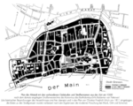 Frankfurt am Main: Plan of the Altstadt (Old Town) with the buildings and street names present in the time around 1350 according to a street directory created by the canon of the Bartholomaeusstift (Bartholomew Monastery)
 -
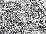
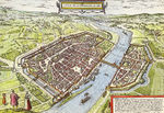 Historical sight of the German town of Frankfurt by Georg Braun and Frans Hogenberg (between 1572 and 1618)This map shows the ancient city wall and moat that surrounded Frankfurt town
 -
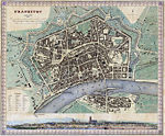 The plan shows the information published under the Superintendence of the Society for the Diffusion of Useful Knowledge, show the Frankfurt green belt where the ancient wall was once built, and demolished in the 19th Century and grassed over
 -
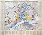 The work of Julius Eduard Foltz-Eberle published in 1852 has been the most famous map of the city until the publication of the plan by Ravenstein in 1862.


Images Frankfurt City between 796 - 1880
-
 St. Catherine's Gate, Frankfurt am Main. The church on top right is St. Catherine's, the square on top left is Hauptwache square in central Frankfurt. The gate was bulit in late 12th century and demolished 600 years later
 -
 Medieval city walls, in the early 19th Century were demolished and grassed over.Thus, in the heart of the city from the former defensive wall is well worth seeing green belt.
 -
 Frankfurt am Main, Germany: This part shows the Judengasse (jewish ghetto) and the monastery of the dominican order.
 -
The building, as well as the adjacent tower to the three Sauköpfen are clearly visible. East of the aisle is the Arnsburger yard to look at their southern end of the bridge tower in Frankfurt.
-
 River Layer
 -
 Open/Green space Layer
 -
 Pathway Layer
 -
 Traffic Layer
 -
 Urban Layer

.png)


Please publish your findings here
Exercise 3: Behaviour Patterns
Time frame: December 6 - 20, 2011
- How do people behave in this area? How do they use the space? What is important for them?
- Observation of study area, interviews with local people and mapping of use patterns.
- Preparation of short presentation
Please publish your findings here
Exercise 4: Communication Concepts
Time frame: December 19, 2011 - January 17, 2012
- Based on the different landscape assessment approaches students will develop a communication concept for their area of study
- Which measures would be necessary for enhancing the awareness for the area?
- Students are free to choose their method.
Please publish your findings here
Image Gallery
-
your image text
-
your image text
-
your image text
-
your image text
-
your image text
References
* Please make sure that you give proper references of all external resources used.
* Do not use images of which you do not hold the copyright.
* Please add internet links to other resources if necessary.
About categories: You can add more categories with this tag: "", add your categories