Nordstadt Park: Difference between revisions
Cashfangcn (talk | contribs) |
Cashfangcn (talk | contribs) |
||
| Line 53: | Line 53: | ||
Image:traffic in nordstadtpark.jpg|your image text | Image:traffic in nordstadtpark.jpg|your image text | ||
Image:plants in nordstadtpark.jpg|your image text | Image:plants in nordstadtpark.jpg|your image text | ||
Image: | Image:Water_in_nordstadtpark.jpg|your image text | ||
Image:yourimagename.jpg|your image text | Image:yourimagename.jpg|your image text | ||
</gallery> | </gallery> | ||
Revision as of 21:36, 1 December 2011
The Boundary of Nordstadt Park in Kassel
| Name | The boundary of Nordstadt Park | |
| Location | Kassel | |
| Country | Germany | |
| Authors | Tanja Helbing,Fang Yi | |

| ||
| <googlemap version="0.9" lat="51.326965" lon="9.505663" zoom="16" width="300" height="250">51.326495, 9.506435, the boundary of Nordstadt park</googlemap> | ||
Short Introduction to the Area of Study
Our chosen area is joined on the south-west side to the Nordstadtpark in Kassel. The area expands parallel to the park. Tree bridges connected the park with our location. Very relevant for the character of the area is a concrete wall on one side and the stream of the Ahna on the other side.
The location can be seen as a place in between, because it connects other main places like the park and the streets. That can be seen as one vital aspects why the area seams to be really interesting to look at. To figure out what kind of potential areas with a pre assumed minor impotence can have for people. Because of the basis of first observational research we figured out that the area is mainly used by younger people and leisure sportsman.
Exercise 1: Sketching the Landscape
Time frame: October 25 - November 15, 2011
Student activities:
- Creation of analytical drawings and sketches
- Presentation of results
Please upload a selection of your drawings/sketches/mental maps and add them to the image gallery
Sketches and Drawings
-
 your image text
 -
 your image text
 -
 your image text


.JPG)
Exercise 2: Landscape Layers
Time frame: November 15 - 29, 2011
- time based changes and 'landscape biography', and/or:
- topography, open spaces, built, green, traffic and water structures on different layers. *Definition of zones with coherent character
- Description of this character.
-
 your image text
 -
 your image text
 -
 your image text
 -
 your image text
 -
your image text


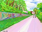
In the east of the area is the Hospital of Kassel located. Next to the graffiti wall is a presumably private used garage. In the northwest there are some private houses.
Regional endemical plants can be found around the area, such as Acer Platanus, Salix or Pinus. Most of the plants deviate along the river side. A contrast between the green and the concrete elements builts up.
Predominantly the area is used by pedestrians and bicycle users. Some parts are accessible for cars too. The frequency highly depends on the time of the day. It is especially high approximately fifteen minutes before and after the lectures.
The hole area appears to be quite open. If you would stand on one side of the place you could easily get an overview about the reach of the place. The open areas can be divided in those who can be accessed by people and in those you can not enter.
On every side of the food path people can enter the joint areas until the wall on the right and the fence on the left side. In addition, there is a little place in front of the path that can be used as well.
The areas people can not enter lay behind the fence and the wall (green spaces). Even though you can not access the places there can be well seen and contribute a big amount to the specific character of the place.
The occurrence of water, has a secondary meaning for the area. There is just one waterelement: the Ahna. It is a little stream that runs through the place on the left side. It appears to be hidden on some places and is there for marginal recognizable.
Exercise 3: Behaviour Patterns
Time frame: December 6 - 20, 2011
- How do people behave in this area? How do they use the space? What is important for them?
- Observation of study area, interviews with local people and mapping of use patterns.
- Preparation of short presentation
Please publish your findings here
Exercise 4: Communication Concepts
Time frame: December 19, 2011 - January 17, 2012
- Based on the different landscape assessment approaches students will develop a communication concept for their area of study
- Which measures would be necessary for enhancing the awareness for the area?
- Students are free to choose their method.
Please publish your findings here
Image Gallery
-
your image text
-
your image text
-
your image text
-
your image text
-
your image text
References
* Please make sure that you give proper references of all external resources used.
* Do not use images of which you do not hold the copyright.
* Please add internet links to other resources if necessary.
[[Category:Everyday Landscapes Working Group About categories: You can add more categories with this tag: "", add your categories