Rothschild Boulevard: Difference between revisions
Heike.kaiser (talk | contribs) |
Heike.kaiser (talk | contribs) |
||
| Line 74: | Line 74: | ||
<gallery caption="topography" widths="150px" heights="150px" perrow="5"> | <gallery caption="topography" widths="150px" heights="150px" perrow="5"> | ||
Image:Rothshild-01.jpg| | Image:Rothshild-01.jpg|Marmorek St. / Habima Theater | ||
Image:Rothshild-02.jpg|your image text | Image:Rothshild-02.jpg|your image text | ||
Image:Rothshild-03.jpg|your image text | Image:Rothshild-03.jpg|your image text | ||
Revision as of 15:54, 28 November 2011
---> back to overview of Case Study List
Strolling along Tel Aviv's oldest and most famous boulevard and its surrounding
| Name | Rothschild Boulevard | |
| Location | Tel Aviv-Yafo | |
| Country | Israel | |
| Authors | Heike Kaiser | |

| ||
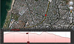
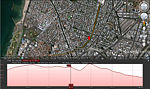
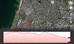
| <googlemap version="0.9" lat="32.067665" lon="34.775162" type="satellite" zoom="15" width="300" height="250">
</googlemap> | ||
Short Introduction to the Area of Study
Rothschild Boulevard is one of Tel Aviv’s major streets, and certainly it’s most famous: As one of the city’s first four streets, it was built on top of sand dunes. First named Rehov Ha’Am (literally – the ‘Street of the people‘), it was changed to Sderot Rothschild in 1910, in honor of Baron de Rothschild, member of the French branch of the famous banking dynasty. It was designed as a boulevard because the Jewish settlers were unable to drain the small wadi that ran there and were compelled to construct on both sides of the street, leaving the center for pedestrians, thus making it into the city’s first boulevard. It is here that the Independence Hall is located, the site where the first Israeli Prime Minister, David Ben Gurion, declared the establishment of the State of Israel, on the 14th of May, 1948.
Nowadays, the boulevard has a designated promenade for pedestrians and bicycle as its centerpiece; it is the financial center of Israel’s only metropolis, with the Tel Aviv Stock Exchange and all the head offices and branches of the big banks and brokerage houses. But it is also a culinary hotspot, with posh restaurants on either side of the boulevard and in adjacent streets; a café mecca that has trendy spots in and around the avenue; a nightlife center with nearby Lillinblum St. offering the city’s largest concentration of bars.
The boulevard starts in Neve Tsedek on its southwestern end and goes east, intersecting with Herzl and Allenby until it reaches the Habima National Theater. It’s one of the most expensive streets in TA, thanks to some beautiful structures that have been kept in excellent condition or have been carefully renovated, forming part of the White City recognized by UNESCO as World Heritage Site since 2003. The boulevard is residential between Habima and Mazeh Street. Its most active (and expensive) part lies north of its intersection with Allenby Street. Many of the smaller streets connecting with Rothschild here have the same historical-yuppie atmosphere, architectural style and cultural significance. Thus, one should not just walk up and down Rothschild but stroll around in search for some “gems“. South of the Allenby intersection, business is less active but experts consider that area to be the boulevard's future as some luxury residential projects are planned for the area.
The boulevard and its surrounding attract the young and the beautiful, the rich big spenders, as well as parents with strollers or dog walkers with plastic bags. You can spend few lovely hours walking around, mixing a bit of people-watching, resting on one of the promenade's benches, sipping coffee or having business lunch in one of the cafés or restaurants.
Exercise 1: Sketching the Landscape
Time frame: October 25 - November 15, 2011
Student activities:
- Creation of analytical drawings and sketches
- Presentation of results
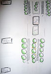
Please upload a selection of your drawings/sketches/mental maps and add them to the image gallery
Sketches and Drawings
-
 northern beginning / end of the boulevard near Habima Theater
 -
 sitting area close to Mazeh St.
 -
 central part of the boulevard
 -
 Artists' Chair
 -
 Founders' Square at the southern end / beginning of the boulevard near Neve Tzedek
 -
 sections I
 -
 sections II
 -
 sections III
 -
 sections VI
 -
 sections V


Exercise 2: Landscape Layers
Time frame: November 15 - 29, 2011
- time based changes and 'landscape biography', and/or:
- topography, open spaces, built, green, traffic and water structures on different layers. *Definition of zones with coherent character
- Description of this character.
- history
- topography
-
 Marmorek St. / Habima Theater
 -
 your image text
 -
 your image text
 -
 your image text
 -
 your image text
 -

-

-

-


Please publish your findings here
Exercise 3: Behaviour Patterns
Time frame: December 6 - 20, 2011
- How do people behave in this area? How do they use the space? What is important for them?
- Observation of study area, interviews with local people and mapping of use patterns.
- Preparation of short presentation
Please publish your findings here
Exercise 4: Communication Concepts
Time frame: December 19, 2011 - January 17, 2012
- Based on the different landscape assessment approaches students will develop a communication concept for their area of study
- Which measures would be necessary for enhancing the awareness for the area?
- Students are free to choose their method.
Please publish your findings here
Image Gallery
-
your image text
-
your image text
-
your image text
-
your image text
-
your image text
References
* Please make sure that you give proper references of all external resources used.
* Do not use images of which you do not hold the copyright.
* Please add internet links to other resources if necessary.
About categories: You can add more categories with this tag: "", add your categories