Collaborative Design Planting Design Working Group 17: Difference between revisions
| Line 61: | Line 61: | ||
Image:perspective_majunge.jpg|Projective basis and natural dynamics | Image:perspective_majunge.jpg|Projective basis and natural dynamics | ||
Image:pathways and stairs.jpg|Strategy for path structures and platforms (rooms) | Image:pathways and stairs.jpg|Strategy for path structures and platforms (rooms) | ||
Image:G17_drainage.jpg|Strategy for drainage | Image:G17_drainage.jpg|Strategy for drainage (Integration of hydraulic dynamics) | ||
Image:Proposal strategy for planting.jpg|Strategy for planting | Image:Proposal strategy for planting.jpg|Strategy for planting | ||
</gallery> | </gallery> | ||
Revision as of 17:06, 26 January 2014
---> back to group page working group 17
Prahova's Riverbed Valley
| Name | Prahova Valley | |||||||||||
| Location | Breaza City | |||||||||||
| Country | Romania | |||||||||||
| Authors | Merchedes Perez, Ma Junge, Tanase Gabriel-Iulian | |||||||||||

| ||||||||||||
| {{#widget:GoogleMaps | width=300 | height=200 | lat=45.182702 | lng=25.676118 | zoom=14 | centermarker=yes | maptypecontrol=yes | overviewmapcontrol=yes | largemapcontrol=yes | scalecontrol=yes
}} | ||
Landscape and/or urban context of your case
The site we have selected as a collaborative assignment is the Prahova River Valley, with a considerable smaller region. Mainly the active site for analysis is in direct contact with the Breaza city center. Breaza City segment that we chose was modified a few years earlier due to the landslide. The land aspect has been dramatically changed as well as the vegetation and the woodland. Therefore the aesthetic and functional aspect of this valley will change drastically.
The site is located on the SubCarpethian Area, at a height of 380m-450m that includes Prahova's riverbed. The climate is temperate-continental specific to hilly areas. Also one Important charasteristic of the valley is the quallity of the air due to the ozone and negative ions which makes the air have an therapeutic effect. Furthermore the area has a noticeble bioclamate characterised by the low values of atmopheric pressure due to the air purity. On the other side the geographic position allows the area to have a rich vegetation, especially due to decidous forrests. About the native plants we can mention: Populus alba, Betula pendula, Sambucus nigra, Rosa canina, Fraxinus excelsior. Finally, the surroundings of the site there are formed by 1400 ha of orchards covered with fruited plants, 1500 ha of forrest and 1800 ha of pastures and hayfields. We can say the the site has high quality characteristics that makes it a very interesting site for landscaping.
What are the objectives of your design?
The main objectives of our design are four in total. First one reffers to reclaiming the lost land in the landslide or in the urban transformation of the riverbed, either be woodland or just ground terrain. The second objective is to create a strong physical connection between the center of the city and the new reclaimed land. The third objective is to integrate the new urban developments, for example the hydroplant situated at the base of our site, on the riverbed, into the new design of the valley improving their aethetical and functional values. The fourth and final objective is to minimize the negative impact of the urban development and trying to design the river beams to give them the natural aspect the valley once had.
Analytical drawings
- Analytical Drawings
-
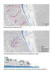
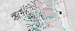 connectivity disfunctions between the valley and the city
 -
 undervalued and unused perch and view points of the Prahova Valley
 -
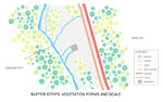 Buffer strips: vegetation form and scale
 -
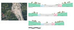 Cross sections
 -
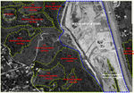 Characterization of land cover, referred to the vegetation dynamic
 -
 1st plant selection: some species from vegetation class of Prahova Valley


Projective drawings
Please add four projective sketches/drawings (or montages/schemes), of course with an emphasis on planting design/vegetation aspects. Every group member needs to contribute at least one drawing representing his/her individual ideas.
- Projective Drawings
-
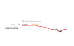
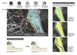 Projective basis and natural dynamics
 -
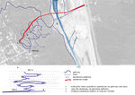 Strategy for path structures and platforms (rooms)
 -
 Strategy for drainage (Integration of hydraulic dynamics)
 -
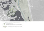 Strategy for planting


Design Synthesis
Please analyse the individual approaches presented so far and evaluate their strengths and weaknesses (you may use the SWOTanalysis model). Try to create a synthesis and represent it with a plan and some sketches. You can still use drawings/sketches.
- Design Synthesis Drawings
-
synthesis drawing 1
-
synthesis drawing 2
-
synthesis drawing 3
-
synthesis drawing 4
Summary of the collaborative process
Please reflect on your collaborative design process. Which potentials have you encountered? What was most difficult? What does collaborative design mean for you? (approx 150 words).
Image Gallery
You may add a series of images/photos in addition to the sketches/drawings
- Image Gallery
-
image 1
-
image 2
-
image 3
-
image 4
References
* Please make sure that you give proper references of all external resources used.
* Do not use images of which you do not hold the copyright.
* Please add internet links to other resources if necessary.
About categories: You can add more categories with this tag: "", add your categories