Taizhou: Difference between revisions
| Line 138: | Line 138: | ||
This is a project for the design company,but for us ,we just use it as a program for workshop. | This is a project for the design company,but for us ,we just use it as a program for workshop. | ||
And we mean to focus on the process and procesure of the program. | And we mean to focus on the process and procesure of the program. | ||
[[#toc|'''Back to top''']] | |||
=== planning process === | === planning process === | ||
Revision as of 14:29, 14 January 2009
This case is to design a wetland park in Taizhou, Zhejiang Province, China
Rationale: Why is this case study interesting?
- This case is to design a wetland park in Taizhou,Zhejiang Province in China,which is the project in our workshop.We aim to understand the process and procedure of how to use the layer cake method to analysis the site background and do further design.
- In this workshop,according to different programs,we are divided into several groups to do the exact different designs, which are extreme proection, extreme development,and balanced development and wetland protection.In this way ,we can understand the project better and know totally different options for one area.It is interesting and helpful,also we can know how to deal with the project in other ways from other groups.It might also be effective in other situations in teaching.
- Also,as the wetland is becoming more and more important in our life,we need to focus more on the wetland.So a wetland park in the countryside for city is a good way for people to reach nature and get to protect the environment.
Author's perspective
- What theoretical or professional perspective do you bring to the case study?
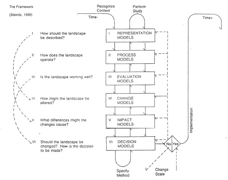
The framework of Steinitz and the method of Layer cake in the analysis and alternative ways to design.
 Back to top
History
- How did the area/project/plan at the focus of the case study evolve?
Jianyang Lake is a lagoon of 1.3 square kilometers evolved from the ancient gulf. However, since early 1950s, the lake had been developed as reform-through-labor farms and then fish market by leveeing and duging dikes which leads to the river ports of the top lake and the bottom lake connected gradually. The lake is narrowing, the southern part even disappeared. Till now, the water surface area is only about 0.7 square kilometers.
Illustration: Table or time line
Landscape context
location :Taizhou,Zhejiang Province in China,which is east to East China Sea, south to Wenzhou, west to Lishui and Jinghua,and north to Shaoxin and Ningbo
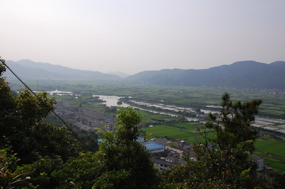
area:The wetland area is called Jianyang lake. And it is divided into two parts,the upper lake and the down lake,with the whole area of about 0.7 square kilometers.And the planning area is more than sie square kilometers.
terrain: The landform of Taizhou City is multiplicity and topography inclines from west to east,with mountains and hills taking up 2/3 of the l and areas. In the southeast ,the hills extend smoothly, while the plain area is so wide with rivers all around.
Climate: This area belongs to subtropical monsoon zone, with the main feature of absolute distinct four seasons.There is plenty of rain fall, sunshine and heat.Perennial leading wind is the northwest wind, with mainly east- northeast winds from April to May, and south-southwest winds from June to July. Climate major disasters are often caused by heavy rains and typhoon floods.
cultural features:There are a lot of vernacular landscape in Jianyang lake area,which can be divided into the following groups:
- Structure of mountains and rivers
- Agricutural landscape
- Spirital places
- Buildings and constructions
- Historical streets
Hydrology As the largest inland lake in Taizhou, Huangyan District, Jianyang Lake is around 1.25 square kilometres. It connects the South-Eastern runoff and Shanshui runoff, and South-Eastern runoff is one part of South-Middle runoff. The plain area in Huangyan has plenty of rivers and runoff, and South-Middle runoff and Shanshui runoff are the main rivers of this region. The South-Middle runoff is 15~22m wide, 12km long, and is the main drainage channel of the South part of Huang yan region; Shanshui runoff is 21~30m wide, 13.65m long, and is the main flood drainage channel of Jinwei Harbor in Tai Lake Mountain region. There are frequent flood disasters in the channel segment of connected region between Jianyang Bridge and Shanshui runoff, because its topography is low, being surrounded by mountains from three sides. The mountain flood goes down quickly, but the water cannot discharge in time. Jianyang Lake is divided into 2 parts: Upper Lake and Down Lake, and is 2500m long in east-west direction, 500m wide in south-north direction. The area of it is 0.7 square kilometres, while the diameter is 4 kilometre. And the lake is divided into 130 small fishponds.
Vegetation The main types of vegetation are:
- Forest vegetation mainly locates in Ma Hill、Jilong Hill、Pipa Hill and Baiyang Hill around Jianyang Lake.
- Agricultural vegetation mainly locates in the plain area surrounded by Jianyang Lake and Mountains around.
- Wetland vegetation mainly locates in waterfront region around Jianyang Lake.
- Shrubbery mainly locates in field bunds and areas around Jianyang Lake.
Cultural/social/political context
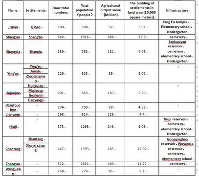
Socio-economic:There is a large area of farmland and villages around the area of Jianyang Lake,which are along the roads and rivers as a "line" for distribution.There are several villages located in this area which are listed in the following table:
Distribution of population:
Industrial construction: The economic structure of Yuanqiao Town,which the lake is located in, mainly dues to the secondary industry, while the total proportion of agriculture and the tertiary industry is lower.The areas of Jiangyang Lake base on aquaculture, agriculture and forestry, and the agricultural products are extremely abundant ,especially the characteristic products as Dongkui waxberry, tomatoes, sugarcane, water chestnuts and seedlings.
Other context
- What are the main structural features?
The cuurent fishpond and farmland are so natural and beautiful,that they form the main structural features of the site,which will provide us some hints to use in the design.
- How has it been shaped? Were there any critical decisions?
Within thousands of years,people live here and work here, they made this by chance. But it happen to be the most sustainable and clever way to fitthe site. But there are also problems that the environment are being destroyed and the fishponds have done harm to the wetland. And the pollution is quite crucial right now. So it is important to protect the environment and give back the natural impression of the site.
Analysis of program/function
- What are the main functional characteristics?
At present ,the site is used for the local people to raise fish , plant plants and fruit trees. The form of the fish pond is interesting;and the structure of native farmland is charming. The the lake in the site is used for fishpond.
- How have they been expressed or incorporated?
Illustration: Map/diagram/sketches photos and background notes
Analysis of design/planning process
- Spatial analysis of area
These are mountains,rivers,fields,buildings,historical heritage and structure.We use these maps to make analyses ,and pick out which is good,which is bad,which should be protected and which should be deleted.In this way ,we get a final analyses map to giude our design in the next step.
Analysis of program
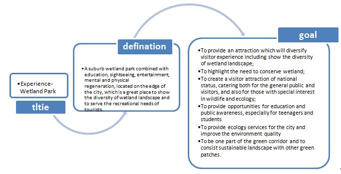
Title:We make our title-- Experience-Wetland Park,which means : A suburb wetland park combined with education, sightseeing, entertainment, mental and physical regeneration, located on the edge of the city, which is a great place to show the diversity of wetland landscape and to serve the recreational needs of tourists.
Goal:
- To provide an attraction which will diversify visitor experience including show the diversity of wetland landscape;
- To highlight the need to conserve wetland;
- To provide ecology services for the city and improve the environment quality
- To be one part of the green corridor and to consist sustainable landscape with other green patches.
- How was the area/project/plan formulated and implemented?
In the workshop,we are divided into six groups to understand the method.
- »EXTREME PROTECTION« - This scenario focuses only to reclamation works, improvements of ecological condition of the space particularly wetland. Practically no development is allowed accept for some basic infrastructure. (group 1)
- »EXTREME DEVELOPMENT« - This scenario allows new development in terms of new housing areas of different types, new hotel and other tourist areas, commercial centers, services centers, etc. Wetland is considered to be an urban wetland park that serves as an attraction for visitors. (group 6)
- »BALANCED DEVELOPMENT AND WETLAND PROTECTION« - As there are four more groups, there are four scenarios going from extreme protection toward extreme development. Meaning that group 2 takes the extreme protections scenario and allows more development, next group more development, and more, and more. (groups 2 – 5)
- Were there any important consultations/collaborations?
This is a project for the design company,but for us ,we just use it as a program for workshop. And we mean to focus on the process and procesure of the program.
planning process
The above diagram shows the process of the design,and in the process of analysis ,we make clear defination of the title and gaols which will lead us to further design.It can be seen in the following diagram:
Core Questions Working Group Green Structure Planning
How does funding influence the planning and use of public space?
As this is a workshop program,we don't focus on the funding.
How are spaces within the site used both currently and projected?
- analyze the current space within the site;
- evaluate them and classify them into several degrees;
- keep the best ones,renew or do little to the average ones, and change the bad ones;
How can the historic elements / layers be integrated?
In the site, there are a lot of historic elements ,which we call it the vernacular landscape.
In the processof design,we try to protect the vernacular landscape,and use the form and structure of them. Also ,when we design something new,we should always think about the structure of the vernacular landscape, in this case ,we can combine the new landscape and the historical landscape together well.
How do the contributing elements of water relate to the project?
In this program, water is an important element,so we pay a lot of attention to the water. As the map below:
How does the built environment relate to the landscape around it?
Analysis of use/users
- How is the area/project/plan used and by whom?
- Is the use changing? Are there any issues?
Illustration: Map/diagram/sketches photos and background notes
Analysis maps
Master plan
Evaluation and verification of the plan
After we got a general idea about the master plan,we begin to evaluate it in order to perfect the it and verify the feasibility and characteristics.During the process,we try to make our own evaluation criteria from the following aspects:
- Evaluation from the definition of the title:
- Evaluation from ecological point of view
- Evaluation from economical point of view
- Evaluation from social point of view
Future development directions
- How is the area/project/plan evolving?
- Are there any future goals?
Illustration: Map/diagram/sketches photos and background notes
Peer reviews or critique
- Has the area/ project/plan been reviewed by academic or professional reviewers?
- What were their main evaluations?
Pleas add references, quotes...
Points of success and limitations
- What do you see as the main points of success and limitations of the area/project/plan?
Illustration: Summary table
What can be generalized from this case study?
- Are there any important theoretical insights?
Short statement plus background notes
Which research questions does it generate?
Short statement plus background notes
Image Gallery
[[Image:|none]]
- Yourimage.jpg
your image text
- Yourimage.jpg
your image text
- Yourimage.jpg
your image text
- Yourimage.jpg
your image text
- Yourimage.jpg
your image text
- Yourimage.jpg
your image text
- Yourimage.jpg
your image text
- Yourimage.jpg
your image text
References
Please add literature, documentations and weblinks
About categories: You can add more categories by copying the tag and filling in your additional categories


