Group A - Collaborative Climate Adaption Project: Difference between revisions
No edit summary |
No edit summary |
||
| Line 207: | Line 207: | ||
In addition to its low temperatures and polar night, Barrow is one of the cloudiest places on Earth. Owing to the prevailing easterly winds off the Arctic Ocean, Barrow is completely overcast slightly more than 50% of the year. It is at least 70% overcast 62% of the time. | In addition to its low temperatures and polar night, Barrow is one of the cloudiest places on Earth. Owing to the prevailing easterly winds off the Arctic Ocean, Barrow is completely overcast slightly more than 50% of the year. It is at least 70% overcast 62% of the time. | ||
[[File:Wind_speed.png|200px|thumb|left|Wind Speed]] | [[File:Wind_speed.png|200px|thumb|left|Wind Speed]] | ||
[[File:Cloud_cover | [[File:Cloud_cover.png|200px|thumb|left|Median Cloud Cover]] | ||
Revision as of 18:23, 5 January 2013
| Place | Barrow | |||||||||||
| Country | Alaska | |||||||||||
| Topic | Effects of climate change and adaptation possibilities - case study from Barrow, Alaska | |||||||||||
| Author(s) | Palmowska Agnieszka, Shrestha Neha, Szilagyi-Nagy Anna | |||||||||||

| ||||||||||||
| Source | http://www.alaskadispatch.com | |||||||||||
| {{#widget:GoogleMaps | width=300 | height=200 | lat=71.295556 | lng=-156.766389 | zoom=8 | centermarker=yes | maptypecontrol=yes | overviewmapcontrol=yes | largemapcontrol=yes | scalecontrol=yes
}} | ||
Rationale: Why have you selected this case study area?
- We have selected the area of the city Barrow, which is located in the north of Alaska, because this area is a perfect example to show that climate change is really progressing and causes the changes in many main areas of life. Barrow is known as the "Ground Zero for Climate Change".
- To select this area also encouraged us Dr. Klaus Görgen who talked about problems in Barrow, Alaska, during the first online seminars.
Authors' perspectives
- We are a landscape architects so we are closely associated with the climate, and also we have to constantly adapt to climate change. Showing the problem from the perspective of a place so distant may be helpful in understanding the general problem of climate change and will expand our knowledge about this topic.
- It is important that everyone should be aware that climate change is a global problem and its consequences are visible even in the farthest regions of the world.
Landscape and/or urban context
- Biogeography, land use patterns, cultural features, overall character, history and dynamics
- ratio of green/blue and sealed/built-up areas
Illustration: Map; sketches; short descriptive analyses
Urban contex of city Barrow
The immediate Barrow situated in Alaska, in the largest and nordernmost state in U.S. (1,477,300 km2, it extends, to the Eastern Hemisphere so the westernmost and easternmost as well) which has more ocean coastline than all of the other U.S. states combined (6640 miles). http://www.fas.org/sgp/crs/misc/RS21729.pdf and a capital, Juneau, that is only accessible via ship or air.
Barrow is the most famous city of the Northern Economic Region, because it is northernmost town in the United States. This region is the remote, less crowded part of the state, encompassing 380 native villages and small towns such as Nome, Bethel, Kotzebue, King Salmon, Dillingham, and includes Katmai National Park, Kodiak Island, and Unalaska-Dutch Harbor.
With approximately 4,500 residents, the Barrow area has probably the harshest weather in Alaska. It is one of the world's largest Inupiat Eskimo settlement where traditional culture and modern life are blended. While many modern conveniences are available, the subsistence life style is still very much in evidence, and fishing, hunting, and whaling are a way of life. North Slope oil discovery has brought wealth to the area, including modern influences such as snowmobiles, but it has been continuously occupied for 5,000 years by people who have learned how to live in the harsh arctic climate. The sun shines and never sets for 82 days from early May to early August and it is dark for 51 - 67 days (the sun never rises) between November and January.


Infrastructure, quality of life
The city itself is hardly accessable just with plane or ship. For researchers, local ground transportation can be provided on a reimburseable basis by BASC and include trucks, four wheelers, snow machines and small to relatively large boats. Local vehicle hire and taxi services are also available. Off road traffic is limited to the period of permanent seasonal snow cover (ca. October-May).
•As the seat of the North Slope Borough, many regional health and social services are located in Barrow. Some of the public facilities include: senior citizen center, city teen center, women's shelter, and family services center. Health care, police station and fire stations.
•Many Barrow homes are heated by natural gas from nearby gas fields, and have modern water and sewer systems. Utilities are available through Barrow Utilities and Electric Cooperative, a local member-owned cooperative, which offers electric power, natural gas, and water and sewer services. The North Slope Borough provides trash and sewer pick-up free of charge.
•Seven churches, an elementary, middle and high school and a post secondary education center, Ilisagvik College, serve the community. On evenings and weekends, the high school's swimming pool, weight room and gym are open to the public. Residents also use Barrow's recreation center, which boasts a gym, racquetball courts, weight room and sauna.
•Communications in Barrow include phone, mail, a public radio station and cable TV station. The community also contains four hotels, many restaurants, a dry cleaner and a bank. Barrow has a large grocery/merchandise store and several convenience stores. The City of Barrow regulates the import of alcoholic beverages, and sale is banned. Major repair services include marine engine, boat, auto and aircraft mechanics. Diesel, propane, marine gas, aviation fuel, unleaded, regular and supreme gas are available for purchase.


Population
In Alaska there is a total underserved population of 370,088, representing 59% of the state’s residents. This reflects Alaska’s low population density and extreme rural nature. (acrh-ahec.uaa.alaska.edu) The lowest ratio of the total population live in this area (3.4%) (http://www.labor.state.ak.us/research/pop/present/jan272011.pdf page 2), but it means also the majority of Alaska's native populations (of which approximately 59.3 percent are Inupiat Eskimo.) (http://www.arcticscience.org/aboutBarrow.php), so this is largest Iñupiat town in Alaska (Barrow takes its modern name from Point Barrow, named in 1825 by Captain Beechey of the Royal Navy for Sir John Barrow of the British Admiralty. Beechey was plotting the Arctic coastline of North America at the time. http://www.arcticscience.org/aboutBarrow.php). They traditionally, call the community Ukpeagvik, "place where snowy owls are hunted" and make their living in similar fashion to their ancestors.
Flora and fauna, landscape types
•The landscape consists of polygonized tundra, vegetated drained lake basins, ponds and lakes.
•Vegetation types include aquatic, seasonally flooded, wet, moist, dry and occasionally bare ground. The Coastal Plain flora includes 124 vascular plant species, 177 mosses, and 49 hepatics (Brown 1980).
•Terrestrial fauna include 10 mammal species and 28 bird species.
•Birding in the Arctic: Barrow is one of the top 100 birding spots in America. Although the diversity of birds is somewhat small, the annual visitors are spectacular. All four species of Eider ducks migrate along the coast and nest in the tundra around Barrow. Numerous other ducks and waterfowl also nest in the millions of small puddles and lakes across the tundra. Barrow is also prime habitat for many shorebirds. Perhaps the most spectacular summer visitor and breeder is the snowy owl, from which comes the Inupiat name for Barrow, Ukpeagvik, which translates to "place to hunt snowy owls". Now, of course, the owls are observed and studied. Barrow is the only spot in America one can reliably expect to see the elusive Ross's gull, which shows up, sometimes in great numbers during the last week of September through the first couple of weeks of October.
•Polar Bears & Whales: According to the local tour operators, the very best time to see polar bears is after the fall whaling season. Although it is possible to see them at the Point anytime of the year, October and November allow for the most likely viewing opportunities. In late May and early October, the Eskimo natives go Bowhead whaling. During whaling season there is an opportunity to photograph a whale being brought in on the beach and butchered. Whaling season tends to encourage the polar bears to feast on the remains that are left at Point Barrow. The bears seldom ever make it into town so you would need a tour to see them. The King Eider Inn, in Barrow, has set up a page with a list of the tours available.
•The northeast corner of Alaska is covered by the Arctic National Wildlife Refuge, which covers 19,049,236 acres (7,708,952 ha).
Cultural/social/political context
- Brief explanation of culture, political economy, legal framework


Culture
•The first people to inhabit Alaska have a rich history of tradition and lifestyle that enabled them to survive the unique challenges of living in the northern latitude.
•Alaska's Native people are divided into eleven distinct cultures, speaking eleven different languages and twenty-two different dialects.
•Residents of the northern part of Alaska belong to two groups - The Inupiaq and the St. Lawrence Island Yupik People.
•The Inupiaq and the St. Lawrence Island Yupik People (or “Real People”) are still hunting and gathering societies. For them the extreme climate is not a barrier. They continue to subsist on the land and sea of north and northwest Alaska. Their lives continue to evolve around the whale, walrus, seal, polar bear, caribou and fish. For them family and bartering connections are respectful and meaningful. Division of labor is dependent on gender. Competitive games to examine the strength and durability of the participants, songs battles and other activities are still an important part of their culture.
•Inupiat were actively celebrated Christian and national holidays, including Thanksgiving, Christmas, New Year's Day, Easter, and Independence Day.
•Also the important traditional ceremony still actively participated in through the 1960s [and continuing to the present] was the nalukatak, or spring whaling festival. Arrangements for this celebration, which took place at the end of the whaling season, were made by the successful umialiks (whaling captains) and their families. If no whales were caught, there was no ceremony.
Historical overlook
The full history of Alaska can be found on the website http://www.akhistorycourse.org/timelines/pre1741.php .
• Barrow is among the oldest permanent settlements in the United States. Hundreds of years before the European Arctic explorers showed up, starving and freezing and succumbing to hardship, Barrow was more or less where it is now, a natural hunting place at the base of a peninsula that pokes out into the Beaufort Sea.
• Archaeological sites in the area indicate the Inupiat lived around Barrow as far back as AD 500.
• Some remains of 16 dwelling mounds from the Birnirk culture of about AD 800 are still in evidence today on the shore of the Arctic Ocean. Their position on a slight rise above the high water mark places them in danger of being lost to erosion within a short time.
• Later, the military came, setting up a radar station, and in 1947 a science center was founded at Barrow.
• The United States Army established a meteorological and magnetic research station at Barrow in 1881, and the Cape Smythe Whaling and Trading Station was established in 1893.
• In 1888 a Presbyterian church was built at Barrow, and in 1901 a United States Post Office was opened.
• In 1972, the North Slope Borough was established. The borough, with millions of dollars in new revenues, created sanitation, water and electrical utilities, roads, fire departments, and health and educational services in Barrow and the villages of the North Slope.
• In 1986, the North Slope Borough created the North Slope Higher Education Center, which later became Ilisagvik College, which is now an accredited two-year college dedicated to providing an education based on the Inupiat culture and the needs of the North Slope Borough.
• In 1988, Barrow became the center of a worldwide media attention when three California Gray Whales became trapped in the ice offshore.[26] After a two week rescue effort (Operation Breakthrough), two of the whales were ultimately freed by a Soviet icebreaker.
Economy


Barrow is the economic, transportation and administrative center for the government of the 230,509 square kilometer North Slope Borough. The region is national leader in fisheries economics, oil and gas economics, transportation infrastructure, waterfront and harbor development planning and has played a pivotal role in the expansion of many port facilities.
Approximately one-third of the working population of 1,955 is employed by the private sector. Some work for oil companies at Prudhoe Bay. The borough employs 46.2 percent of the work force and the School District employs another 19.3 percent.
Although everyone thought the income should be among the lowest bertween the Uniated States, ALaska is on the first place with its $42,931 median housholds (Income, per household, separating higher half of household incomes and lower half of household incomes in a state) according to 2000 census fromn 1993.
They are working into the next sectors:
•Services
o Government services, public schools, public hospitals and military bases.
o Tourism is a major sector of Alaska's economy attracting over one million visitors annually. Tourism provides a major summer activity using plane from Anchorage, Fairbanks or Deadhorse. Transportation to Barrow is by scheduled daily commercial airline from Anchorage or Fairbanks, service from Deadhorse (Prudhoe Bay) or charter airlines. On clear nights this is a good time to view the northern lights and go dog sledding. Spring whaling occurs in May, and villagers celebrate Nalukataq in June and early July (it celebrates the end of whaling season.) If you are interested in birding, polar bears, or dogsledding October through May, this is the place to come. A new Heritage Center, opened in 1999, is a "must see" for every visitor.
o During the summer months, tour operators offer package tours of Barrow and the surrounding area. Visitors might be interested in purchasing such arts and crafts as baleen boats, etched baleen, carved ivory, masks, parkas and fur mittens.
o Barrow is served by passenger jet service from Anchorage and Fairbanks. Freight arrives by barge in the summer and air cargo year-round.
• Mining
o Oil and gas exploration and development to the east, south and offshore from Barrow provide revenue to the local community. Oil provides about 95 percent of Alaska's mining income. o Other mined products are gold, zinc, silver, coal, crushed stone, lead, molybdenum, and sand and gravel.
• Local subsistence hunting is common and focuses on marine mammals, fish, waterfowl and caribou.
o Fishing: The most important commercial fishing ports are at Kodiak and Unalaska/Dutch Harbor. Large catches of cod, flounder, pollock, rockfish, sablefish, salmon, and smelt drive the industry. Dungeness crab, king crab, scallops, sea urchins, shrimp, snow crab, and herring eggs are other important products of the fleet. o Agriculture: There are only about 500 farms in Alaska, most clustered in the 880,000 acre Matanuska Valley northeast of Anchorage. In terms of revenue generated, Alaska's top five agricultural products are greenhouse and nursery products, hay, dairy products, potatoes, and cattle and calves.
Legal framework
Instead of local divisions of government established as counties, Alaska is divided into a group of boroughs (16) and geographical census areas (11) and has 6 economic regions - Anchorage/Mat-Su Economic Region, Gulf Coast Economic Region, Interior Economic Region, Northern Economic Region, Southeast Economic Region, and Southwest Economic Region - that have their own role in the state and have their typical geographical and economic features.
In the statutes of Alaska, we can find all the information about the legal provisions, which are in force in Alaska. All statutes can be found on the website http://www.touchngo.com/lglcntr/akstats/statutes.htm . Among them we can find provisions regarding health, safety, and also information about the Alaska State Climate Center, which is responsible for providing information about the climate and temperatures occurring in Alaska. Direct link to the statutes about the establishment of Alaska Climate Center - http://www.touchngo.com/lglcntr/akstats/Statutes/Title14/Chapter40/Section085.htm
Local Climate
- What are the climatic conditions at present? Have there been extreme weather events in the near past?
- Which changes are expected? Is there any evidence?


Barrow's climate is cold and dry, and is classified as a polar climate. Winter weather can be extremely dangerous because of the combination of cold and wind, while summers are cool even at their warmest.
It is interesting that in Barrow the sun sets on November 18 or 19, and it remains below the horizon for about 65 days. This creates a polar night that lasts until the sun rises again around January 22 or January 23. During the first half of the polar night, there is a decreasing amount of twilight each day, and on the winter solstice (around December 21 or December 22), civil twilight in Barrow lasts for a mere 3 hours.
In addition to its low temperatures and polar night, Barrow is one of the cloudiest places on Earth. Owing to the prevailing easterly winds off the Arctic Ocean, Barrow is completely overcast slightly more than 50% of the year. It is at least 70% overcast 62% of the time.


Analysis of vulnerability
- If you consider these potential changes - which aspects/functions of your case study would be affected?
Illustration: Map/diagram/sketches/photos/background notes
Proposals for Climate Change Adaption
- How could your case study area become more resilient to climate change?
- Which measures would need to be taken to adapt to the new situation?
- How could you assure sustainability of these measures?
- Please describe 2-3 measures
Proposals for Climate Change Mitigation
- Which measures would need to be taken to reduce greenhouse gas emissions and other drivers of climate change within your case study area?
- How could you assure sustainability of these measures?
- Please describe 2-3 measures
Your scenario
- How will this area look like in 2060?
- Please forecast one potential future development taking climate change into account
Illustration: Map/diagram/sketches photos and background notes
What can be generalized from this case study?
- Are there any important theoretical insights?
- Which research questions does it generate?
- Short statement plus background notes
Presentation Slides
-
Slide One
-
Slide Two
-
Slide Three
Image Gallery
-
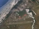 Satellite map
 -
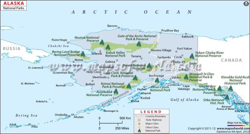
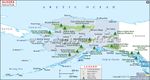 Alaska National Parks
 -
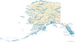 Rivers in Alaska
 -
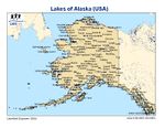 Lakes of Alaska
 -
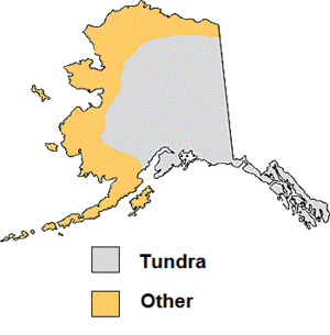
 Tundra
 -
your image text
-
your image text
-
your image text
-
your image text


References
1. http://en.wikipedia.org/wiki/Geography_of_Alaska 2. http://fairbanks-alaska.com/barrow.htm 3. http://www.eu-interact.org/field-sites/barrow/ 4. http://www.arcticscience.org/aboutBarrow.php 5. Wohlforth, Charles P. (2007). Frommer's Alaska 2008. Frommer's. p. 434. ISBN 0-470-15288-5, ISBN 978-0-470-15288-1 6. http://fairbanks-alaska.com/barrow.htm 7. http://www.google.pl/intl/pl/earth/index.html 8. http://www.akhistorycourse.org/articles/article.php?artID=156 9. http://www.akhistorycourse.org/articles/article.php?artID=151 9. http://www.labor.state.ak.us/research/pop/present/jan272011.pdf 10. http://www.fas.org/sgp/crs/misc/RS21729.pdf 11. http://www.northerneconomics.com 12. http://www.arcticscience.org/aboutBarrow.php 13. http://www.census.gov/population/www/cen2000/phc-t2.html (July 10, 2001) 14. Carpenter, Alan, and Carl Provorse. The World Almanac of the U.S.A.. Mahwah: World Almanac Books, 1996. Print. 15. http://www.netstate.com/economy/ak_economy.htm 16. http://www.arcticscience.org/aboutBarrow.php 17. http://www.netstate.com/economy/ak_economy.htm 18. http://www.netstate.com/states/government/ak_government.htm
Source of jpg: 8. http://www.alaskadispatch.com 9. http://www.akhistorycourse.org/images/akheritage/large/unit2chart5.jpg 10. http://www.akhistorycourse.org/images/geography/large/l5.jpg 11. http://www.akhistorycourse.org/images/geography/large/l6.jpg 12. http://www.mapsofworld.com/usa/national-parks/maps/alaska-national-parks.jpg 13. http://www.worldlakes.org/uploads/ALASKA2.jpg 14. http://www.hookandbullet.com/c/fishing-barrow-ak/#ixzz2FJNKJTZs 15. http://geology.com/state-map/maps/alaska-rivers-map.gif 16. http://soundwaves.usgs.gov/2008/03/GOA_AkMapLG.gif 17. http://www.fs.fed.us/land/ecosysmgmt/colorimagemap/ecoreg1_akprovinces.gif 18. http://microbewiki.kenyon.edu/images/thumb/9/98/Tundra_map.gif/300px-Tundra_map.gif 19. http://labor.alaska.gov/research/census/econregions.pdf 20. http://economicinfo.org/ 21. http://weatherspark.com/averages/32906/Barrow-Alaska-United-States
About categories: You can add more categories with this tag: "", add your categories
{{#widget:WidgetName|param1=value1|param2=value2}}