Dupont Area of Martinez: Difference between revisions
| Line 75: | Line 75: | ||
<gallery caption=" " widths="150px" heights="150px" perrow="5"> | <gallery caption=" " widths="150px" heights="150px" perrow="5"> | ||
Image:2_001 | Image:2_001.jpg|Interaction, people/building. Red=high interaction. Commercial/office area. Green=personal interaction. Residential area | ||
Image: | Image:3_001.jpg|STREETS Red=high traffic, Orange=slow traffic, DESTINATION Green=residential area, Blue= office area(Dupont), Yellow=commercial area | ||
Image:1_001.jpg|Red=standing, Green=sitting, Purple=fast walking, Turquoise=slow walking, Blue=biking | Image:1_001.jpg|Red=standing, Green=sitting, Purple=fast walking, Turquoise=slow walking, Blue=biking | ||
Image:yourimagename.jpg|your image text | Image:yourimagename.jpg|your image text | ||
Revision as of 15:55, 7 January 2012
---> back to overview of Case Study List
Dupont Area
| Name | Dupont Area | |
| Location | Martinez, Buenos Aires | |
| Country | Argentina | |
| Authors | Sonia Agosti de Landa | |

| ||
| <googlemap version="0.9" <googlemap version="0.9" lat="-34.501446" lon="-58.52241" type="map" zoom="16" width="300" height="250">
</googlemap> | ||
Short Introduction to the Area of Study
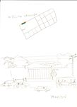
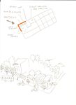
This area is in Martinez in the outskirts of Buenos Aires . It’s located between the streets Hipolito Yrigoyen, Panama, Corrientes and Fleming Avenue. In the area you can find residential houses, a gas station, some commercial stores and offices. I named the project “Dupont area” because you can find here the offices of the company. It’s, no dough, an everyday landscape from Buenos Aires suburbs, since most of the suburbs have grown with not much urban design, regulation or planning. Damian, Buenos Aires coordinator, suggested the area to me. I visited the area and thought that it would be a challenging area to be studied. Although it’s a place I do not feel related to, it might be interesting to understand its evolution and think of a proposal for a change.
Exercise 1: Sketching the Landscape
Time frame: October 25 - November 15, 2011
Student activities:
- Creation of analytical drawings and sketches
- Presentation of results
Please upload a selection of your drawings/sketches/mental maps and add them to the image gallery
Sketches and Drawings
-
 Santiago del Estero
 -
 Yrigoyen
 -
 Intersection Panama and Yrigoyen
 -
 Intersection Yrigoyen and Fleming
 -
your image text


Exercise 2: Landscape Layers
Time frame: November 15 - 29, 2011
- time based changes and 'landscape biography', and/or:
- topography, open spaces, built, green, traffic and water structures on different layers. *Definition of zones with coherent character
- Description of this character.
-
 Guarani Indians. Pampa. Very scares vegetation=grasses and small trees, ombu (Phytolacca dioica), tala (Celtis tala), spiny bushes. On the Rio de La Plata ceibos (Erithrina cristagalli) and sauces (Salix sp.)
 -
 First subdivision by Juan de Garay in1850. Farms to feed Buenos Aires city dwellers.
 -
 Watershed of Reconquista River and flood-plan. Green 2000 and orange 1995.
 -
 In 1930 The Jockey Club founded the Golf course and a race track= central rectangular green area
 -
 Traffic flow. Red, heavy= buses, cars,small trucks. Blue= residents car, bicycles


Please publish your findings here
Exercise 3: Behaviour Patterns
Time frame: December 6 - 20, 2011
- How do people behave in this area? How do they use the space? What is important for them?
- Observation of study area, interviews with local people and mapping of use patterns.
- Preparation of short presentation
-
 Interaction, people/building. Red=high interaction. Commercial/office area. Green=personal interaction. Residential area
 -
 STREETS Red=high traffic, Orange=slow traffic, DESTINATION Green=residential area, Blue= office area(Dupont), Yellow=commercial area
 -
 Red=standing, Green=sitting, Purple=fast walking, Turquoise=slow walking, Blue=biking
 -
your image text
-
your image text


Please publish your findings here
Exercise 4: Communication Concepts
Time frame: December 19, 2011 - January 17, 2012
- Based on the different landscape assessment approaches students will develop a communication concept for their area of study
- Which measures would be necessary for enhancing the awareness for the area?
- Students are free to choose their method.
-
your image text
-
your image text
-
your image text
-
your image text
-
your image text
Please publish your findings here
Image Gallery
-
your image text
-
your image text
-
your image text
-
your image text
-
your image text
References
* Please make sure that you give proper references of all external resources used.
* Do not use images of which you do not hold the copyright.
* Please add internet links to other resources if necessary.
About categories: You can add more categories with this tag: "", add your categories