River Area Frankfurt Main: Difference between revisions
| Line 223: | Line 223: | ||
* Preparation of short presentation | * Preparation of short presentation | ||
<gallery caption=" " widths="400px" heights=" | <table border="1"> | ||
<tr> | |||
<td> | |||
<gallery caption=" " widths="400px" heights="600px" perrow="5"> | |||
Image:Pattern.jpg|your image text | |||
</gallery> | |||
</td><td> | |||
Image: | <gallery caption=" " widths="150px" heights="150px" perrow="5"> | ||
Image:yourimagename.jpg|your image text | |||
Image:yourimagename.jpg|your image text | |||
Image:yourimagename.jpg|your image text | |||
</gallery> | </gallery> | ||
<gallery caption=" " widths="150px" heights="150px" perrow="5"> | <gallery caption=" " widths="150px" heights="150px" perrow="5"> | ||
Image:yourimagename.jpg|your image text | Image:yourimagename.jpg|your image text | ||
Image:yourimagename.jpg|your image text | Image:yourimagename.jpg|your image text | ||
Image:yourimagename.jpg|your image text | Image:yourimagename.jpg|your image text | ||
</gallery> | |||
<gallery caption=" " widths="150px" heights="150px" perrow="5"> | |||
Image:yourimagename.jpg|your image text | Image:yourimagename.jpg|your image text | ||
Image:yourimagename.jpg|your image text | Image:yourimagename.jpg|your image text | ||
Image:yourimagename.jpg|your image text | |||
</gallery> | </gallery> | ||
</td> | |||
</tr> | |||
</table> | |||
''Please publish your findings here'' | ''Please publish your findings here'' | ||
Revision as of 22:52, 12 December 2011
---> back to overview of Case Study List
add long title of your theme
| Name | Frankfurt am Main River Area | |
| Location | Frankfurt am Main | |
| Country | Germany | |
| Authors | S. Pio Brown Staikidis | |

| ||
| <googlemap version="0.9" lat="50.107093" lon="8.682203" zoom="15" width="300" height="250">
</googlemap> | ||
Short Introduction to the Area of Study
Frankfurt is an international, dynamic and financial city with the highest towering skyscrapers silhouette of Germany, in whose streets the plurality of languages is something natural, famous for the Main River, which is the heart of the city.
The case study area extends from the historical bridge, called Eiserner Steg, to the surroundings of the old Großmarkthalle, place where the new Frankfurt Hafen park, proposed by Sinai Faust Schroll Schwarz Landscape Architects, and landscape areas of the Skytower house of the new European Central Bank, proposed by Vogt Landscape architects are being developed.
The banks of the river are the meeting place of the city, serving as a green space surrounded by museums, historical buildings and parks. It is characterized by its system of circulation, with interconnecting walkways, recreational facilities and open spaces full of contrasts, binding the modern with the traditional, the urban and the rustic associated with the life of the city, becoming an international oasis of culture, history, and landscape development.
Exercise 1: Sketching the Landscape
Time frame: October 25 - November 15, 2011
Student activities:
- Creation of analytical drawings and sketches
- Presentation of results
Please upload a selection of your drawings/sketches/mental maps and add them to the image gallery
Sketches and Drawings
-
 Sketch view of Frankfurt City from the study area
 -
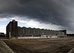
 Construction area of the new sky tower project and Hafen Park in the east site of the Main River in Frankfurt
 -
 View under the railway bridge, closed to the Skytower project
 -
 Study area and surroundings


Exercise 2: Landscape Layers
Frankfurt History
• 794 is the first time the royal estate of "Franconovurd" was mention.
• 1152 Frederick I. is elected German king.
• 1478 Frankfurt Fair (messe). The city is developing in the following decades to one of the most important commercial centers in Germany.
• 1585 -At the end of the Middle Ages, Frankfurt was one of the richest and most powerful commercial centers in central Germany.
• 1866 Frankfurt was annexed by the Prussians. In 1880, the Old Opera House was inaugurated.
• 1884 the first electric tram in the world was put into operation. This was in service between the Old Bridge in Frankfurt and Offenbach am Main.
• Four years later, in 1888, the main railway station, Europe's largest railway station was opened
• 1891-1912 Under Mayor Franz Adickes, Frankfurt developed into a modern industrial and commercial city.
• 1910 is the incorporation of the entire district of Frankfurt.
• 1925-1930 at the instigation of the Mayor Ludwig Landmann to Frankfurt appointed Ernst May as city architect 1925-1930 many new settlements and thus creates the "New Frankfurt".
• In 1926, the Frankfurt airport was open.
• In 1930, the station district, the union hall built as the first skyscraper in the city.
• 1933 After the local elections in March 1933, the Nazis era started
• 1943/44 downtown and old town of Frankfurt by air attacks destroyed almost completely. March 1945 U.S. troops occupy the city.
• On 18 May 1948 find in the rebuilt St. Paul's Church to celebrate the 100th Anniversary of the German National Assembly.
• 1949 Frankfurt is Germany's capital almost came within a few votes.
• 1963 John F. Kennedy visited Germany and speaking on 25 June in St. Paul's Church.
• 1968 begins with the opening of the first subway line, the realization of a new transportation concept.
• 1984 begins the expansion of the museum embankment, which blossomed in subsequent years to the arts and cultural district of the city.
• 1988 Messeturm with Hammering person as a new symbol of the economic power of the metropolis since 1988 characterizes the 256 meter high tower, the fair city of Frankfurt.
• 1995In Euro Tower, the former BfG Tower, 1995 provided by the European Monetary Institute, forerunner of today's European Central Bank,
• 1997, the Commerzbank Tower, completed with 258m Europe's tallest office tower. Other "Skycraper" (Main Tower, Trianon, Main Plaza, Gallileo) follow.
• 1998 the headquarters of the European Central Bank (ECB) given to Frankfurt.
• 2000 "Urbanity" is the buzzword of the new millennium.
Historic plans showing the evolution of Frankfurt City
|
|


Images Frankfurt City between 796 - 2011
-
 St. Catherine's Gate, Frankfurt am Main. The gate was bulit in late 12th century and demolished 600 years later
 -
 Medieval city walls, in the early 19th Century were demolished and grassed over.Thus, in the heart of the city from the former defensive wall is well worth seeing city green belt.
 -
 World War II. About 5,500 residents killed. The largest medieval city centre in Germany destroyed, were 12,197 tons of explosives dropped on the city.
 -
 Inaugurated in October 1928. The largest building complex in the city, from October 1941 the National Socialists used the market as a collection point for the deportation of Jewish. Therefore played an important role in the genocide of the Holocaust within the machinery of destruction.
 -
 View of frankfurt Landscape in 1980
 -
 Actual Frankfurt

.png)


Landscape Layers
|
|


Please publish your findings here
Exercise 3: Behaviour Patterns
Time frame: December 6 - 20, 2011
- How do people behave in this area? How do they use the space? What is important for them?
- Observation of study area, interviews with local people and mapping of use patterns.
- Preparation of short presentation
|
|

Please publish your findings here
Exercise 4: Communication Concepts
Time frame: December 19, 2011 - January 17, 2012
- Based on the different landscape assessment approaches students will develop a communication concept for their area of study
- Which measures would be necessary for enhancing the awareness for the area?
- Students are free to choose their method.
-
your image text
-
your image text
-
your image text
-
your image text
-
your image text
Please publish your findings here
Image Gallery
-
your image text
-
your image text
-
your image text
-
your image text
-
your image text
References
* Please make sure that you give proper references of all external resources used.
* Do not use images of which you do not hold the copyright.
* Please add internet links to other resources if necessary.
PGNU Das Planungsbüro für Landschaftsarchitektur, Landschaftsplanung, Umweltanalyse, Umweltbaubegleitung, Naturschutz und Artenschutz
www.acg.org/frankfurt/
http://www.reiserat.de/reisen_deutschland/wm-staedte/frankfurt.htm
Landschaften im Osten Frankfurt
http://frankfurt-interaktiv.de/frankfurt/geschichte/fakten.html
http://www.frankfurt1933-1945.de/
http://www.frankfurt.de/sixcms/detail.php?id=3070&_ffmpar
http://www.aiv-frankfurt.com/?page_id=2
http://www.deutsches-architektur-forum.de/forum/index.php
http://www.discusmedia.com/catalog.php?catId=5.2.6
About categories: You can add more categories with this tag: "", add your categories