Rural school of San Eduardo: Difference between revisions
No edit summary |
|||
| Line 34: | Line 34: | ||
''Please upload a selection of your drawings/sketches/mental maps and add them to the image gallery'' | ''Please upload a selection of your drawings/sketches/mental maps and add them to the image gallery'' | ||
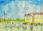
=== Sketches and Drawings === | |||
<gallery caption=" " widths="150px" heights="150px" perrow="5"> | <gallery caption=" " widths="150px" heights="150px" perrow="5"> | ||
Revision as of 19:10, 14 November 2011
Rural school of San Eduardo and around, Trenque Lauquen, Argentina
| Name | Escuela San Eduardo | |
| Location | Trenque Lauquen, Buenos Aires | |
| Country | Argentina | |
| Authors | Alejandra Gutierrez | |

| ||
| <googlemap version="0.9" lat="-36.223988" lon="-62.790985" type="satellite" zoom="14" width="300" height="250">
</googlemap> | ||
Short Introduction to the Area of Study
The area under study is located in the center of Argentina in a plain area of big farms devoted to agriculture, livestock and milk production. It is a very well communicated area through a net of dirt and paved roads. In the middle of a productive landscape, the rural school of San Eduardo is a meeting point, a landmark, a meeting place for adults and the only place where the sons and daughters of rural workers can get education.
This area is important to me because I have worked in a farm and in the school in the coordination of a Rural Development Project through which twenty women were trained to generate handcrafts small enterprises. Now, I am doing my Doctorate research in Anthropology, where I explore how children and women living in the area see and feel their everyday landscape.
Exercise 1: Sketching the Landscape
Time frame: October 25 - November 15, 2011
Student activities:
- Creation of analytical drawings and sketches
- Presentation of results
Please upload a selection of your drawings/sketches/mental maps and add them to the image gallery
Sketches and Drawings
-
 your image text
 -
 your image text
 -
 your image text
 -
 your image text
 -
 your image text


Exercise 2: Landscape Layers
Time frame: November 15 - 29, 2011
- Classical analysis: topography, open spaces, built, green, traffic and water structures on different layers. *Definition of zones with coherent character
- Description of this character.
Please publish your findings here
Exercise 3: Behaviour Patterns
Time frame: December 6 - 20, 2011
- How do people behave in this area? How do they use the space? What is important for them?
- Observation of study area, interviews with local people and mapping of use patterns.
- Preparation of short presentation
Please publish your findings here
Exercise 4: Communication Concepts
Time frame: December 19, 2011 - January 17, 2012
- Based on the different landscape assessment approaches students will develop a communication concept for their area of study
- Which measures would be necessary for enhancing the awareness for the area?
- Students are free to choose their method.
Please publish your findings here
Image Gallery
-
your image text
-
your image text
-
your image text
-
your image text
-
your image text
References
* Please make sure that you give proper references of all external resources used.
* Do not use images of which you do not hold the copyright.
* Please add internet links to other resources if necessary.
About categories: You can add more categories with this tag: "", add your categories