Parks in Neu Oerlikon: Difference between revisions
| Line 117: | Line 117: | ||
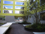
Image:Bild_6.png|Buildings next to the Oerliker Park | Image:Bild_6.png|Buildings next to the Oerliker Park | ||
Image:Bild_3.png|MFO Park | Image:Bild_3.png|MFO Park | ||
Image: | Image:RIMG1522Kopie.jpg|MFO Park | ||
Image:RIMG1490Kopie.jpg|your image text | Image:RIMG1490Kopie.jpg|your image text | ||
Image:yourimage.jpg|your image text | Image:yourimage.jpg|your image text | ||
Revision as of 16:33, 9 December 2008
Parks in Neu Oerlikon, Zurich, Switzerland: MFO Park, Wahlen Park, Oerliker Park
| Name | Parks in Neu Oerlikon | |
| Place | Zurich | |
| Country | Switzerland | |
| Topic | Public space | |
| Authors | Yvonne Keller, Lars Wolfer | |
| Completion | 2005 | |
| Client | Grünstadt Zürich | |
| Project costs | Wahlen Park: 4 400 000 €, Oerliker Park & MFO- Park: unknown | |

| ||
| <googlemap version="0.9" lat="47.410781" lon="8.557491" zoom="15" width="300" height="250">
</googlemap> | ||
Rationale: Why is this case study interesting?
In the north of Zurich a new quarter developed: Neu (new-) Oerlikon. The planned urban development proceeded not as the foreseen 10 years. It has been allready realized in 5 years. That quarter is considered as a pioneer project. Large-scaled architectural competition was arranged for fastidious buildings and internationally considered places, partly already realized. Although the quater is international advertance, its inhabits deplore the missing life, anonymity, too few meeting places, the coldness of architecture and the too perfect parks.
Author's perspective
- What theoretical or professional perspective do you bring to the case study?
Landscape and/or urban context
Neu Oerlikon is in the north of Zurich and developed on a former industrial area. 12,000 new jobs and domiciles for 5,000 new inhabitants developed. There are three new main parks: Oerliker park, MFO park and Wahlen park. The organization of the parks reminds strongly of the former industrial use. orthogonal and geometrical alignments are coining for these. In the context of the rearrangement of zones of the industial zone in trade and apartment zone, a large pressure developed on the planners . They had to fulfill the edition to sufficient green area to create. Thus three different park types with special uses developed. The Wahlen park had to fulfill still the task of a schoolyard. The Oerliker park had to have the qualities of an accomodation park and besides an urban place character to obtain. The MFO park should have the multi-functionality of an event hall and besides offer free space for employed persons.

Cultural/social/political context
- Brief explanation of culture, political economy, legal framework
Illustration: Bullet points, image, background notes
History
Oerlikon was the seat of the formerly largest weapon factory of Switzerland. At that time the „Oerlikon-Bührle“ could owe the rearmament efforts around 1938 large orders secure itself and supplied both European-wide and until Asia. 1966 to 1969 on the area shooting tests with ammunition uranium-bearing were accomplished. 1999 the firing ranges were broken off and disposed of as special refuse. Today there is a park and a new family-friendly housing development. However it does not exist a danger for human’s health and environment. On this historical significant industrial area in the last 10 years an apartment and a service center were planned, which becomes in these days reality.
Illustration: Table or time line
Spatial analysis of area/project/plan
- What are the main structural features?
- How has it been shaped? Were there any critical decisions?
Illustration: Map/diagram/sketches photos and background notes
Core questions working group open spaces
How does the design of an open space contribute to a run down neighbourhood?
test, test, test
How are open spaces linked to the adjacent areas?
(e.g. neighbourhoods, city centre, river)
How are open spaces used?
(e.g. which groups meet there, which functions does an open space fulfil)
Which elements make an open space successful and attractive?
How can the historical background of an open space be shown to the public?
Core Questions Working Group Public Space and Civic Identity
Who was involved in the participation process?
How was the participation process implemented (methods applied)?
In how far does/did the project respond to people's needs?
Analysis of program/function
- What are the main functional characteristics?
- How have they been expressed or incorporated?
Illustration: Map/diagram/sketches photos and background notes
Analysis of design/planning process
- How was the area/project/plan formulated and implemented?
- Were there any important consultations/collaborations?
Illustration: Map/diagram/sketches photos and background notes
Analysis of use/users
- How is the area/project/plan used and by whom?
- Is the use changing? Are there any issues?
Illustration: Map/diagram/sketches photos and background notes
Future development directions
- How is the area/project/plan evolving?
- Are there any future goals?
Illustration: Map/diagram/sketches photos and background notes
Peer reviews or critique
- Has the area/ project/plan been reviewed by academic or professional reviewers?
- What were their main evaluations?
Pleas add references, quotes...
Points of success and limitations
- What do you see as the main points of success and limitations of the area/project/plan?
Illustration: Summary table
What can be generalized from this case study?
- Are there any important theoretical insights?
Short statement plus background notes
Which research questions does it generate?
Short statement plus background notes
Image Gallery
-
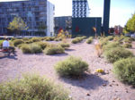
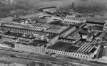 Former Industrial Area in Oerlikon
 -
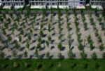 Oerliker Park - bowery in grid
 -
 Schoolyard Wahlen Park
 -
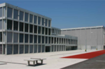
 Buildings next to the Oerliker Park
 -
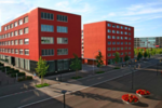
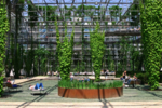 MFO Park
 -
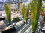 MFO Park
 -
 your image text
 -
your image text
-
your image text
-
 your image text


References
Please add literature, documentations and weblinks
About categories: You can add more categories by copying the tag and filling in your additional categories