Collaborative Green Infrastructure Design Group G: Difference between revisions
| (14 intermediate revisions by 2 users not shown) | |||
| Line 92: | Line 92: | ||
''Please give a short written argumentation (not more than 150 words). It is ok if you have different or even contradicting objectives within your group. Just make it explicit at the beginning of your process '' | ''Please give a short written argumentation (not more than 150 words). It is ok if you have different or even contradicting objectives within your group. Just make it explicit at the beginning of your process '' | ||
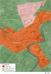
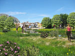
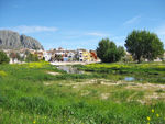
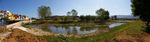
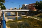
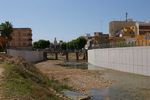
From one view point, There is not enough connection between the river and some green islands (Green spaces) in the town (Photo: The town, The river and Green islands -Current condition). If it could be possible to make a connection between the green islands of the town and also between the island and the river, we would have more ecological, sustainable and aesthetic landscape. | |||
== Analytical drawings == | == Analytical drawings == | ||
| Line 107: | Line 109: | ||
<gallery caption="Projective Drawings " widths="150px" heights="150px" perrow="4"> | <gallery caption="Projective Drawings " widths="150px" heights="150px" perrow="4"> | ||
Image:Proposed for future.jpg|The town, The river and Green islands (Proposed for future) | Image:Proposed for future.jpg|The town, The river and Green islands (Proposed for future)(Majid) | ||
Image:River_proposal1.jpg|Projective drawing of the river sides (Catalina) | Image:River_proposal1.jpg|Projective drawing of the river sides (Catalina) | ||
Image:Solutions.jpg|GI solution for built and natural areas (Catalina) | Image:Solutions.jpg|GI solution for built and natural areas (Catalina) | ||
Image: | Image:River-girona-public-use-def.jpg|The river as a green public space (Maria) | ||
</gallery> | </gallery> | ||
| Line 117: | Line 119: | ||
<gallery caption="Design Synthesis Drawings" widths="150px" heights="150px" perrow="4"> | <gallery caption="Design Synthesis Drawings" widths="150px" heights="150px" perrow="4"> | ||
Image: | Image:Design Synthesis Group G -1.jpeg|synthesis drawing 1 | ||
Image: | Image:Design Synthesis Group G -2.jpeg|synthesis drawing 2 | ||
Image: | Image:River-girona-public-use-def.jpg|synthesis drawing 3 | ||
Image:yourfilename4.jpg|synthesis drawing 4 | Image:yourfilename4.jpg|synthesis drawing 4 | ||
</gallery> | </gallery> | ||
| Line 125: | Line 127: | ||
== Summary of the collaborative process == | == Summary of the collaborative process == | ||
''Please reflect on your collaborative design process. Which potentials have you encountered? What was most difficult? What does collaborative design mean for you? (approx 150 words).'' | ''Please reflect on your collaborative design process. Which potentials have you encountered? What was most difficult? What does collaborative design mean for you? (approx 150 words).'' | ||
the case study (Girona river and The town) has good potentials and opportunities to be a more rich and sustainable landscape. Some important Opportunities are as bellow: | |||
- Connection to the sea | |||
- Connection to different small towns across the river | |||
- Proximity to protected areas | |||
- Agricultural landscape and a dense network of paths | |||
It is believed that, this proposed plan (current study) could be executed in the site. Adding the green infrastructures is a important criteria in this plan. It would solve some current weaknesses and Threats in the site (mentioned in this page). As a result of applying this plan, more sustainable, healthy and effective landscape would be seen in future. | |||
== Image Gallery == | == Image Gallery == | ||
| Line 130: | Line 144: | ||
<gallery caption="Image Gallery" widths="150px" heights="150px" perrow="4"> | <gallery caption="Image Gallery" widths="150px" heights="150px" perrow="4"> | ||
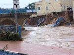
Image: | Image:flood1_byPCRG.jpg|Flood on 2007 | ||
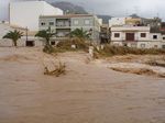
Image: | Image:flood2_byPCRG.jpg|Beniarbeig bridge collapsed 2007 | ||
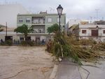
Image: | Image:flood3_by_PCRG.jpg|Flood El Verger 2007. Bridge under water | ||
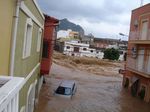
Image: | Image:flood4_by_PCRG.jpg|Flood El Verger 2007 | ||
Image:flood5_by_PCRG.jpg|flood El Verger 2007 | |||
Image:El_verger_riu_girona_by_Espencat.jpg|Girona River at El Verger | |||
Image:Riu_Girona_a_Beiarbeig_by_Espencat.jpg|Girona River at Beniarbeig | |||
Image:pan_beniarbeig_vora-concava_b.jpg|Meander at Beniarbeig | |||
Image:pan_riu_verger_b.jpg|Arundo donax | |||
Image:riu1.jpg|Bird taking a bath | |||
Image:Riu2.JPG|River at Beniarbeig | |||
Image:Riu3.JPG|River at Beniarbeig | |||
Image:Riu4.JPG|Entering to El Verger | |||
Image:Riu5.JPG|your image text | |||
Image:Riu7.JPG|your image text | |||
Image:Riu8.JPG|your image text | |||
Image:Riu9.JPG|your image text | |||
Image:Riu10.JPG|your image text | |||
Image:Riu11.JPG|Under the highway | |||
Image:Riu12.JPG|Highway | |||
Image:riu13.jpg|Els Poblets | |||
</gallery> | </gallery> | ||
== References == | |||
Confederación hidrogràfica del Júcar (CHX) (2009): Lluvias de octubre de 2007. Trabajos realizados por la Confederación Hidrogràfica del Júcar. Ministerio de Medio Ambiente. | |||
Confederación hidrogràfica del Júcar (CHX) (2011) version preliminar: Memora del Plan Director de Defensa Contra las Avenidas en la Comarca de la Marina Alta. Ministerio de Medio Ambiente. | |||
' | |||
Costa Mas, J. (1977): El marquesat de Dénia. Estudio geográfico. Departamentos de geografia de Valencia y Alicante, Universitat de València. ISBN: 84-370-0041-6 | |||
Costa Mas, J. (2008): El marco geográfico, demográfico y económico de la comarca de la Marina Alta. En: “Historia de la Marina Alta” Tomo I. Insitut d'estudis comarcals de la Marina Alta (IECMA). ISBN: 978-84-931704-4-8 | |||
Ripoll Berenguer, M.J. (2008): Pressions i conflictes territorials en el litoral mediterrani: La Marina Alta. Institut Alacantí de Cultura Juan Gil-Albert. Alacant. ISBN: 978-84-7784-538-6 | |||
Segura Beltrán, F. (2009): Geomorfología, inundacions y alteración antròpica del espacio inundable: el caso del riu Girona (Alacant, 2007). Boletín de la Asociación Española de Geógrafos, nº 49, pag. 83-103. ISSN: 0212-9426 | |||
Zamora, L.; Mezquita, F.; Rueda, J. (2005): Biodiversitat i ecología dels invertebrats aquàtics continentals de la Marina Alta i el seu valor com a indicadors de qualitat de les aigües de la comarca. Institut Alacantí de Cultura “Juan Gil-Albert”. Alacant. | |||
http://riuadagirona.blogspot.com | |||
www.daualdeu.wordpress.com | |||
Wikipedia | |||
Google maps | |||
Latest revision as of 04:58, 22 February 2015
---> back to group page working group G
Girona river
| Name | Girona river | |||||||||||
| Location | Marina Alta | |||||||||||
| Country | Spain | |||||||||||
| Authors | Maria Josep Ripoll, Majid Amani Beni, Catalina Papiu-Zoran | |||||||||||

| ||||||||||||
| {{#widget:GoogleMaps | width=300 | height=240 | lat=38.807194 | lng=-0.049115 | zoom=8 | centermarker=yes | maptypecontrol=yes | overviewmapcontrol=yes | largemapcontrol=yes | scalecontrol=yes
}} | ||
Landscape and/or urban context of your case
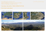
Girona river is born at 650 meters over the see level in the small town of Vall d’Alcalà. In the west side of the Marina Alta county. It has 34.7 km long and his drainage basin has 105 km². The river crosses the spectacular and hilly site known as “Barranc de l’Infern” (Devil’s gorge). It has an important geological and archeological value, and is highly appreciated by hikers and climbers. At the exit of the Devil’s gorge, a dam was builded on 1944 to increase water supply but it failed because of the permeable soil below the damp. Today the damp is almost silt with sediments and it hardly works delaying the flash flood. All these area upstream is a natural protected zone associated to the European Natura 2000. It is protected as a Site of Community Importance (SCI) and a Special Protection Area of Wild Birds (SPA).
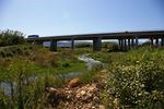
From the damp to the sea, the river has 20.38km long. This stretch of the river plain does not have any kind of protection. After the damp, the river crosses a width river plain that shapes the north of the Marina Alta county. The richest soils for agriculture are found here. The matrix of the river plain is composed mostly by orchards and vegetable gardens. The river is followed by several towns, some of them in the river banks. The river plain is crossed by road infrastructures (motorway, highway, roads). Several urban settlements and activities are placed there: towns, urban sprawl, shopping mall, industrial areas.
Girona River ends in a sandy beach in the Mediterranean sea. It’s last stretch is surrounded by urban sprawl, detached and semi-detached houses for tourists or owned by elderly residents from central and north Europa. A submarine area about 2.200 ha in front of the Girona river mouth is protected as a SCI and SPA because it keeps a big Posidonia oceanica reef (seagrass endemic to the Mediterranean sea) very important for sea birds feeding.
Some details about the towns in the river plain:
Population: Beniarbeig: 1.915 inhabitants (2013) Ondara: 6.613 inhabitants (2013) El Verger: 4.856 inhabitants (2013) Els Poblets: 3.402 inhabitants (2013)
The tourism and foreign residents has an important impact over population and public services. A lot of foreign residents owned a house and spend part of the year in our county; tourist rent a house or a flat or a room in a hotel for vacations. This “floating” population is not included in the population census but they use infrastructures and public services that used to become overloaded on vacations. Most of the foreign residents are elderly which increases the average age and implies more pressure over medical public services.
Economy: The economy of the towns around the Girona river are based mainly on the services sector (tourism, restaurants, transport, retailing and wholesaling, etc.) and construction sector. The industrial sector is formed by small family business based on traditional manufactured items (furniture, leather industry). Nevertheless, the agriculture sector is still important with the traditional production of oranges and the new introduction of kakis.
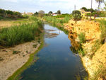
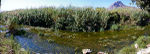
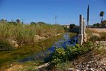
River vegetation and fauna The riverbank vegetation is diverse and mainly composed by perennial vegetation: reedbed (Phargmites communis), rhizomatous grasses (Paspalum paspaloides, Paspalum vaginatum), water vegetation (Ranunculus, Potamogeton, etc.), trees such as Salix, Populus, Pinus halepensis, and bushes such as Nerium oleander, Rubus, Rosa canina, Crataegus monogyna, etc. Nevertheless, one species is dominating along the river: Arundo donax, a perennial invasive cane. This cane grows really fast and is reducing the population of native species. The vegetation gives shelter to different species of fish, amphibian or crustacean. Some of them are endemic and fragile or are endangered. The amount and variety of birds that visit the Girona river is increasing because of the proximity of the Oliva-Pego Marsh Natural Park. Several protected species of birds spend the winter or nest in the marsh and used the Girona river (upstream and downstream) to graze and feeding.
River water quality Using a biological index IBMWP (Iberian Biomonitoring Working Party) it is possible to stablish the water quality depending of the macro- invertebrates collected in different water samples (2004 and 2005). Near the town of Sanet the index was 127 and in El Verger 97, corresponding to index values of very good quality (good ecological condition, water without contamination or not disrupted). (Zamora et al. 2005)
History Before the second half of the 20th century, the river was very important for the daily life of the towns surrounding the river. People got canes as construction material and to feed the livestock. Sand and stones were used in construction too. But most of all, the water was used for irrigation. Some of the towns were really rich providing vegetables and fruits to the market.
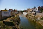
Dynamics The urban pressure and the new economic activities are the dynamics behind it’s degradation. Today the river is almost abandoned. Infrastructures and urban activities near the river are narrowing the river bed and blocking the water flow. And the industrial activities are throwing waste and polluting the water.
- Illustrations
-
 Location
 -
 Description
 -
 Drainage basin
 -
 Tributaires
 -
 Protected areas
 -
 Settlements
 -
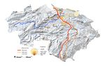
 Study area and case study location
 -
 Study area: river plain land planning
 -
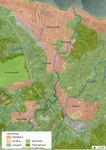 Study area: river plain land zoning
 -
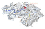
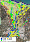 Study area: flood riskiness
 -
 Study area: natural and protected areas
 -
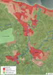
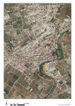 Case study: Beniarbeig. Aerial view
 -
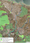
 Case study: Land planning
 -
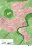 Case study: Land zoning
 -
 Case study: Natural and open areas


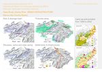
What are the overall objectives of your design? What are the specific objectives for enhancing green infrastrucutre?
Please give a short written argumentation (not more than 150 words). It is ok if you have different or even contradicting objectives within your group. Just make it explicit at the beginning of your process
From one view point, There is not enough connection between the river and some green islands (Green spaces) in the town (Photo: The town, The river and Green islands -Current condition). If it could be possible to make a connection between the green islands of the town and also between the island and the river, we would have more ecological, sustainable and aesthetic landscape.
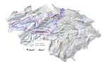
Analytical drawings
Please add four analytical sketches/drawings (or montages/schemes) of your case. Every group member needs to contribute at least one drawing.
- Analytical Drawings
-
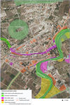
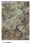
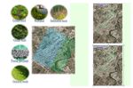
 GI oportunities
 -
 The town, The river and Green islands (Current condition)
 -
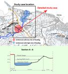 Flooding settlements/river section (Catalina)
 -
analytical drawing 4


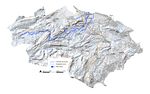
Projective drawings
Please add four projective sketches/drawings (or montages/schemes), of course with an emphasis on green infrastructure aspects. Every group member needs to contribute at least one drawing representing his/her individual ideas.
- Projective Drawings
-
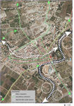
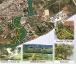
 The town, The river and Green islands (Proposed for future)(Majid)
 -
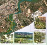 Projective drawing of the river sides (Catalina)
 -
 GI solution for built and natural areas (Catalina)
 -
 The river as a green public space (Maria)


Design Synthesis
Please analyse the individual approaches presented so far and evaluate their strengths and weaknesses (you may use the SWOTanalysis model). Try to create a synthesis and represent it with a plan and some sketches. You can still use drawings/sketches.
- Design Synthesis Drawings
-
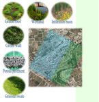
 synthesis drawing 1
 -
 synthesis drawing 2
 -
synthesis drawing 3
-
synthesis drawing 4


Summary of the collaborative process
Please reflect on your collaborative design process. Which potentials have you encountered? What was most difficult? What does collaborative design mean for you? (approx 150 words).
the case study (Girona river and The town) has good potentials and opportunities to be a more rich and sustainable landscape. Some important Opportunities are as bellow:
- Connection to the sea
- Connection to different small towns across the river
- Proximity to protected areas
- Agricultural landscape and a dense network of paths
It is believed that, this proposed plan (current study) could be executed in the site. Adding the green infrastructures is a important criteria in this plan. It would solve some current weaknesses and Threats in the site (mentioned in this page). As a result of applying this plan, more sustainable, healthy and effective landscape would be seen in future.
Image Gallery
You may add a series of images/photos in addition to the sketches/drawings
- Image Gallery
-
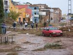 Flood on 2007
 -
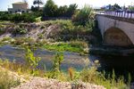
 Beniarbeig bridge collapsed 2007
 -
 Flood El Verger 2007. Bridge under water
 -
 Flood El Verger 2007
 -
 flood El Verger 2007
 -
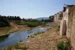
 Girona River at El Verger
 -
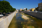
 Girona River at Beniarbeig
 -
 Meander at Beniarbeig
 -
 Arundo donax
 -
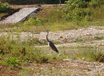 Bird taking a bath
 -
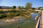 River at Beniarbeig
 -
 River at Beniarbeig
 -
 Entering to El Verger
 -
 your image text
 -
 your image text
 -
 your image text
 -
 your image text
 -
 your image text
 -
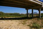 Under the highway
 -
 Highway
 -
 Els Poblets


References
Confederación hidrogràfica del Júcar (CHX) (2009): Lluvias de octubre de 2007. Trabajos realizados por la Confederación Hidrogràfica del Júcar. Ministerio de Medio Ambiente.
Confederación hidrogràfica del Júcar (CHX) (2011) version preliminar: Memora del Plan Director de Defensa Contra las Avenidas en la Comarca de la Marina Alta. Ministerio de Medio Ambiente.
Costa Mas, J. (1977): El marquesat de Dénia. Estudio geográfico. Departamentos de geografia de Valencia y Alicante, Universitat de València. ISBN: 84-370-0041-6
Costa Mas, J. (2008): El marco geográfico, demográfico y económico de la comarca de la Marina Alta. En: “Historia de la Marina Alta” Tomo I. Insitut d'estudis comarcals de la Marina Alta (IECMA). ISBN: 978-84-931704-4-8
Ripoll Berenguer, M.J. (2008): Pressions i conflictes territorials en el litoral mediterrani: La Marina Alta. Institut Alacantí de Cultura Juan Gil-Albert. Alacant. ISBN: 978-84-7784-538-6
Segura Beltrán, F. (2009): Geomorfología, inundacions y alteración antròpica del espacio inundable: el caso del riu Girona (Alacant, 2007). Boletín de la Asociación Española de Geógrafos, nº 49, pag. 83-103. ISSN: 0212-9426
Zamora, L.; Mezquita, F.; Rueda, J. (2005): Biodiversitat i ecología dels invertebrats aquàtics continentals de la Marina Alta i el seu valor com a indicadors de qualitat de les aigües de la comarca. Institut Alacantí de Cultura “Juan Gil-Albert”. Alacant.
http://riuadagirona.blogspot.com
www.daualdeu.wordpress.com
Wikipedia
Google maps
About categories: You can add more categories with this tag: "", add your categories