Collaborative Green Infrastructure Design Group N: Difference between revisions
Boschirolib (talk | contribs) |
|||
| (20 intermediate revisions by 2 users not shown) | |||
| Line 114: | Line 114: | ||
<gallery caption="Projective Drawings " widths="150px" heights="150px" perrow="4"> | <gallery caption="Projective Drawings " widths="150px" heights="150px" perrow="4"> | ||
Image: | Image:0 Scheme.jpg|Barbara agricultural scheme prospective development | ||
Image: | Image:Wetland restauration scheme.png|Elena Wetland Restauration Scheme | ||
Image: | Image:Wetland axonometry.png|Elena Wetland Axonometry | ||
Image: | Image:MONTAZA CAMP2.jpg|Mateja Montaza Children's camp | ||
Image:Social Agricolture.jpg|Mateja Social Agriculture scheme | |||
Image:Social Agricolture vision.jpg|Barbara Social Agriculture Vision | |||
Image:Children's camp.jpg|Mateja Social GI Children's Camp | |||
</gallery> | </gallery> | ||
| Line 124: | Line 127: | ||
<gallery caption="Design Synthesis Drawings" widths="150px" heights="150px" perrow="4"> | <gallery caption="Design Synthesis Drawings" widths="150px" heights="150px" perrow="4"> | ||
Image: | Image:0 Sintesi plan final.jpg|Synthesis Map | ||
Image:Swot group N.png|SWOT | Image:Swot group N.png|SWOT | ||
Image:1 nature swamp txt.jpg|Nature Swamp Axonometry | |||
Image:2 wetland txt.jpg|Wetland Axonometry | |||
Image:3 agri txt.jpg|Agriculture Axonometry | |||
Image:4 social txt.jpg|Social Camp Axonometry | |||
Image:Cost benefit 1.jpg|Cost Benefit Evaluation | Image:Cost benefit 1.jpg|Cost Benefit Evaluation | ||
Image: | Image:Cost benefit 2.jpg|Climate Change, Adaptation and Mitigation | ||
Image:Cost benefit 3.jpg|Health and Wellbeing Benefits of GI Monetised | |||
Image:Cost benefit 5.jpg|Land Management Cost Benefit Evaluation | |||
</gallery> | </gallery> | ||
== Summary of the collaborative process == | == Summary of the collaborative process == | ||
''Please reflect on your collaborative design process. Which potentials have you encountered? What was most difficult? What does collaborative design mean for you? (approx 150 words).'' | ''Please reflect on your collaborative design process. Which potentials have you encountered? What was most difficult? What does collaborative design mean for you? (approx 150 words).'' | ||
When we were trying to chose one site it was not so simple because of so many choices in hand. Once the site chosen(by vote), we tried to understand the particularities of this site by questioning Barbara so many things. The potentials of this site were exactly where its weak points are: that means in the almost unique type of agriculture which can be diversified. We considered the suggestions given like the farmers would take the payments for increased biodiversity. On top of this we calculated the final benefits that this work will bring and it's about a surprising 1 million and a half pounds. Sure there are costs also, but the costs are only 1 third of all the benefits which sounds like a good deal. | |||
It was also difficult sometimes understanding the site, so there were always questions, but the answers to the problems came easily through research and some other case studies surfing. Collaborative design means making choices, listening to others, giving up sometimes when it's needed and most of all learning and developing potentials. | |||
== Image Gallery == | == Image Gallery == | ||
| Line 137: | Line 150: | ||
<gallery caption="Image Gallery" widths="150px" heights="150px" perrow="4"> | <gallery caption="Image Gallery" widths="150px" heights="150px" perrow="4"> | ||
Image: | Image:7_Cavenago d'Adda.jpg|The Cavenago d'Adda old town | ||
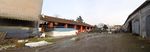
Image: | Image:Bastia Farm1.jpg|One of the Bastia farm from the main road | ||
Image: | Image:The main building_front.jpg|One of the Bastia farm: the building for the farmer family | ||
Image: | Image:Animal shelter_original from last century.jpg|Old animal shelter | ||
Image:15_View from the courtyard.jpg|One of the Bastia farm: the courtyard | |||
Image:4_bastia fields.jpg|The Bastia fields | |||
Image:canal.jpg|The Bastia fields: an old canal | |||
Image:5a_Bastia dead branch.jpg|The dead meander/river branch | |||
Image:3_front view2.jpg|The children camp transformed in a private summer house | |||
</gallery> | </gallery> | ||
== References == | == References == | ||
| Line 150: | Line 167: | ||
''* Please add internet links to other resources if necessary.'' | ''* Please add internet links to other resources if necessary.'' | ||
*http://ec.europa.eu/environment/nature/rbaps/index_en.htm | |||
*http://solmacc.eu | |||
*http://en.wikipedia.org/wiki/SWOT_analysis | *http://en.wikipedia.org/wiki/SWOT_analysis | ||
*http://www.spur.org/blog/2013-08-08/8-shades-green-infrastructure | *http://www.spur.org/blog/2013-08-08/8-shades-green-infrastructure | ||
*http://www.greeninfrastructurenw.co.uk/html/index.php?page=projects&GreenInfrastructureValuationToolkit=true | *http://www.greeninfrastructurenw.co.uk/html/index.php?page=projects&GreenInfrastructureValuationToolkit=true | ||
* | *http://www.balticcompass.org/_blog/Project_Reports/post/Case_study_on_constructed_wetlands_in_Finland/ | ||
*http://www.balticcompass.org/PDF/News/WetlandsCase_Finland.pdf | |||
*http://www.dnr.state.mn.us/wetlands/benefits.html | |||
*http://www.fao.org/docrep/004/y1669e/y1669e0a.htm | |||
*http://issuu.com/wrtdesign/docs/green-infrastructure | |||
*http://issuu.com/victoriabid/docs/bestpracticeguide_a4_10 | |||
*http://www.asla.org/2011awards/217.html | |||
*http://www.asla.org/2011awards/images/largescale/217_09.jpg | |||
*http://www.asla.org/2011awards/images/largescale/217_08.jpg | |||
*http://www.localofficelandscape.com/wp-content/uploads/2014/02/09_PROPOSAL_Axonometric_Edited_For_Web_No_Text.jpg | |||
*http://www.forestry.gov.uk/pdf/urgp_benefits_of_green_infrastructure.pdf/$file/urgp_benefits_of_green_infrastructure.pdf | |||
*http://water.epa.gov/type/wetlands/outreach/upload/EconomicBenefits.pdf | |||
*http://www.ecy.wa.gov/programs/sea/wetlands/functions.html | |||
*http://www.futurarc.com/FuturArc/assets/Image/mainpic19_FP_WetlandPark_FINAL-page-001.jpg | |||
*http://udconnect.net/category/landscape/ecological-landscape/ | |||
*http://www.landezine.com/?s=wetland | |||
*http://www.landezine.com/index.php/2010/05/parco-lineare/ | |||
Latest revision as of 16:51, 27 January 2015
---> back to group page working group N
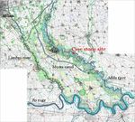
Bastia farms, Cavenago d'Adda, Lodi, Italy
| Name | Bastia farms | |||||||||||
| Location | Cavenago d'Adda, Lodi | |||||||||||
| Country | Italy | |||||||||||
| Authors | Group N | |||||||||||

| ||||||||||||
| {{#widget:GoogleMaps | width=300 | height=200 | lat=45.29438693047742 | lng=9.60909802543938 | zoom=10 | centermarker=yes | maptypecontrol=yes | overviewmapcontrol=yes | largemapcontrol=yes | scalecontrol=yes
}} | ||
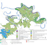
Landscape and/or urban context of your case
- Biogeography, cultural features, overall character, history and dynamics
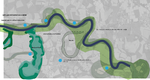
The area is placed along the river Adda, in the south of Lodi town . Milan city is 50 km far away and Lodi town only 12 km. The area is placed inside the Cavenago d’Adda municipality and is located next to the Adda river course. The area is actually inside an old meander of the river and is dedicated to the agriculture production. The context is high relevant from different point of views:
-for the environment, there are a lot of wetlands, some haunting reserves, rich river vegetation, beaches, banks and dykes;
-for the economy, high agriculture use direct to cultivate mais and grass for cow farms to produce the milk in the Grana Padano DOP cheese network;
-for the culture, there are some old urban villages with churches, villas, mills and farms.
The area is next to the current river course and is submitted to several flooding episodes during all the seasons in case of abundant rain. The area is formed by rural active fields, corn and grass, two farms, for cows and milk, and a private building, which was the old river camp of the municipality.
Biogeography
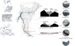
The Adda river is one of the main tributary to the Po, the main river in the north of Italy. The Adda borns in the Alps and crosses all the Lombardia region, passing through the Lecco lake, arrives in the flat area of the Pianura Padana. The Adda river is protected by two regional parks: the North, between the lake and Lodi town, and the South one, from Lodi town to the Po river. The two parks differ for the context the river crosses by and for the river course's features. The case study belongs to the South park area, where the course of the river becomes wider and with a lot of meanders, due to its lower speed across the plain( pic. 1). This part of the plain is dominated by the Adda and the Lambro river courses and by numerous canals for irrigation. The ecologic structure is based on the water courses and on their vegetation areas. (pic.2) The South park is characterized by a series of dead river branches , beside the meanders; one of the most famous is the Soltarico branch, originated from the flood in the 1976 when the river skipped the Soltarico meander and originated 7 km of a series of wetlands and islands. Beside the Soltarico reserve there are other 5 natural reserve made out from dead branches (pic.3). These protected areas (Life EU network) are important for their flora and fauna habitats, rare in the plain around.
The case study is placed in one dead river branch and is the only one not transformed in a protected area.
Even though the importance of these reserves, the Adda South Park has not many touristic structures: there isn’t a continuous path networks on the banks, there aren’t refreshment areas or other structures that could improve the recreation adn leisure.
Climate conditions
Cavenago is 67 m s.l.m. and given the geographical context of the plain we can assure the climate is continental. During winter the temperature could reach the -3-5 Celsius degree, and could snow a bit/lot depends on the year. During summer (between June and September) the temperature could reach the 30-33 Celsius degrees. The coldest mouth is usually January and the hottest July and August. The main fact about climate conditions is the humidity level, which is always high. In winter and autumn could be above the 60 -70 % and in summer too: this means a lot of fog during autumn and winter time and the mist presence during early morning in spring and summer time. In the last two decades the rainiest months of the year were October and November with a monthly rainfall average of 93,3 mm and 113,7 mm. April and September were also quite rainy with a rainfall average of 79,4 mm and 78,2 mm.
Overall character
Water is actually the main resource of the entire Pianura Padana in the south of Milan with rivers, canals, wetlands, irrigation ditches and fontanili . The water table is between 2,50 meter and 1,50 meter deep: if you dig a hole in the ground with your hands you could easily find water. The site is placed in the lowest terrace along the river and has equal share or is few meters higher than the average water level of the river and is therefore floodable in flood periods. For this reason, the site soil is sands and silts, light , loose, fluffy , powdery, medium permeable, with a thin covering of humus.
Cavenago d’Adda has 2234 inhabitants with a density of 138,76 ab./km² in a territory of 16,1 km². The town is placed on a river platform at 73 m s.l.m. but the site is mainly at 60 m s.l.m. The Pianura Padana region is defined by its highly developed and mechanized agriculture. The landscape is dominated by the rhythm of the rural productions, corn and forage for the milk cows, and by the presence of small towns, villages and isolated farms, some of them quite old. Each of these towns and villages has its own church and bell tower, so even when the corn reaches its maximum height, in the end of summer, you can easily orientate yourself looking for the nearest tower or church.
Agriculture
The agriculture system and the rural settlements The municipality land is 57% occupied by herbaceous crops (cereals, rice, maize/corn and permanent grassland), and only the 9% by woodland areas, mainly along the river, and the 34% by inhabited land. The mesh structure on which the agricultural organization is based, is recognizable thanks to the preservation of some trees rows, rural roads and canals maintained in its original state, throughout the years. These elements, with the farms scattered in the territory, represent the objects of the valorization and recovery, indicated by the regional plan, to preserve the original nature of the local landscape. Next to the Adda river there is instead a complex image, characterized by an agricultural reality of high natural level consists predominantly of arable and permanent grassland fields, in addition to a physical natural system very articulate. Despite the strong vocation of the agricultural system, the employed population of Cavenago in the rural system was only the 5% in 2001. In fact , watching the farm buildings, they have a different use than the original function. Many farms still active, but not mainly agricultural engaged, are located within the South Adda Park. The agricultural system and the environment of the park constitute the territorial identity of Cavenago d’Adda, but the trivialization of agricultural landscape due to the affirmation of intensive agriculture, has weakened, if not canceled, an image of an agricultural area made out of “green rooms”.
- Illustrations
-
 1_The big scale
 -
 2_The ecological network
 -
 3_The river and the dead branches of the river


What are the overall objectives of your design? What are the specific objectives for enhancing green infrastrucutre?
Please give a short written argumentation (not more than 150 words). It is ok if you have different or even contradicting objectives within your group. Just make it explicit at the beginning of your process
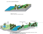
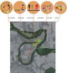
The design will be focused on three themes:
- Water as the main raw material of the area
Investigate the water management alternatives and the potentiality of using water as energy provider for the area, beside with the possibilities of filtering water for freshwater use in and out. Consider some hydroponic systems and maybe some fish growing system or similar, in terms of economic activities.
- Agriculture as an activities capable of taking care of the environment
Find out about old cultivars and ecologically grown food alternatives, exploring the possibilities of enhancing the biodiversity in a cultivate site.
- Slow tourism as a new point of view to explore the territory
Rediscover the cultural heritage of the area, provide all the services to support the tourism activities (accommodations, renovation of buildings, paths and environments etc) and develop a didactic centre for children.
Analytical drawings
Please add four analytical sketches/drawings (or montages/schemes) of your case. Every group member needs to contribute at least one drawing.
- Analytical Drawings
-
 Urban and rural identity
 -
 land use
 -
 Environment-problems
 -
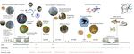 Environment-values


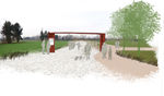
Projective drawings
Please add four projective sketches/drawings (or montages/schemes), of course with an emphasis on green infrastructure aspects. Every group member needs to contribute at least one drawing representing his/her individual ideas.
- Projective Drawings
-
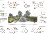 Barbara agricultural scheme prospective development
 -
 Elena Wetland Restauration Scheme
 -
 Elena Wetland Axonometry
 -
 Mateja Montaza Children's camp
 -
 Mateja Social Agriculture scheme
 -
 Barbara Social Agriculture Vision
 -
 Mateja Social GI Children's Camp


Design Synthesis
Please analyse the individual approaches presented so far and evaluate their strengths and weaknesses (you may use the SWOTanalysis model). Try to create a synthesis and represent it with a plan and some sketches. You can still use drawings/sketches.
- Design Synthesis Drawings
-
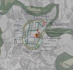 Synthesis Map
 -
 SWOT
SWOT -
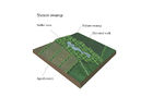 Nature Swamp Axonometry
 -
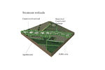 Wetland Axonometry
 -
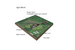 Agriculture Axonometry
 -
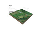 Social Camp Axonometry
 -
 Cost Benefit Evaluation
 -
 Climate Change, Adaptation and Mitigation
 -
 Health and Wellbeing Benefits of GI Monetised
 -
 Land Management Cost Benefit Evaluation


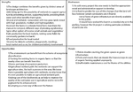
Summary of the collaborative process
Please reflect on your collaborative design process. Which potentials have you encountered? What was most difficult? What does collaborative design mean for you? (approx 150 words).
When we were trying to chose one site it was not so simple because of so many choices in hand. Once the site chosen(by vote), we tried to understand the particularities of this site by questioning Barbara so many things. The potentials of this site were exactly where its weak points are: that means in the almost unique type of agriculture which can be diversified. We considered the suggestions given like the farmers would take the payments for increased biodiversity. On top of this we calculated the final benefits that this work will bring and it's about a surprising 1 million and a half pounds. Sure there are costs also, but the costs are only 1 third of all the benefits which sounds like a good deal.
It was also difficult sometimes understanding the site, so there were always questions, but the answers to the problems came easily through research and some other case studies surfing. Collaborative design means making choices, listening to others, giving up sometimes when it's needed and most of all learning and developing potentials.
Image Gallery
You may add a series of images/photos in addition to the sketches/drawings
- Image Gallery
-
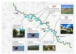
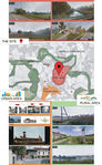
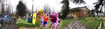
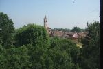 The Cavenago d'Adda old town
 -
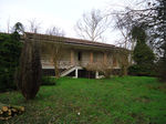
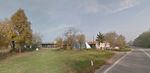 One of the Bastia farm from the main road
 -
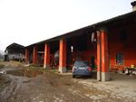 One of the Bastia farm: the building for the farmer family
 -
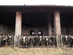 Old animal shelter
 -
 One of the Bastia farm: the courtyard
 -
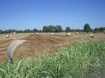 The Bastia fields
 -
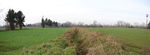 The Bastia fields: an old canal
 -
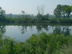 The dead meander/river branch
 -
 The children camp transformed in a private summer house


References
* Please make sure that you give proper references of all external resources used.
* Do not use images of which you do not hold the copyright.
* Please add internet links to other resources if necessary.
- http://ec.europa.eu/environment/nature/rbaps/index_en.htm
- http://solmacc.eu
- http://en.wikipedia.org/wiki/SWOT_analysis
- http://www.spur.org/blog/2013-08-08/8-shades-green-infrastructure
- http://www.greeninfrastructurenw.co.uk/html/index.php?page=projects&GreenInfrastructureValuationToolkit=true
- http://www.balticcompass.org/_blog/Project_Reports/post/Case_study_on_constructed_wetlands_in_Finland/
- http://www.balticcompass.org/PDF/News/WetlandsCase_Finland.pdf
- http://www.dnr.state.mn.us/wetlands/benefits.html
- http://www.fao.org/docrep/004/y1669e/y1669e0a.htm
- http://issuu.com/wrtdesign/docs/green-infrastructure
- http://issuu.com/victoriabid/docs/bestpracticeguide_a4_10
- http://www.asla.org/2011awards/217.html
- http://www.asla.org/2011awards/images/largescale/217_09.jpg
- http://www.asla.org/2011awards/images/largescale/217_08.jpg
- http://www.localofficelandscape.com/wp-content/uploads/2014/02/09_PROPOSAL_Axonometric_Edited_For_Web_No_Text.jpg
- http://www.forestry.gov.uk/pdf/urgp_benefits_of_green_infrastructure.pdf/$file/urgp_benefits_of_green_infrastructure.pdf
- http://water.epa.gov/type/wetlands/outreach/upload/EconomicBenefits.pdf
- http://www.ecy.wa.gov/programs/sea/wetlands/functions.html
- http://www.futurarc.com/FuturArc/assets/Image/mainpic19_FP_WetlandPark_FINAL-page-001.jpg
- http://udconnect.net/category/landscape/ecological-landscape/
- http://www.landezine.com/?s=wetland
- http://www.landezine.com/index.php/2010/05/parco-lineare/
About categories: You can add more categories with this tag: "", add your categories