Collaborative Green Infrastructure Design Group B: Difference between revisions
| (38 intermediate revisions by 4 users not shown) | |||
| Line 63: | Line 63: | ||
== What are the overall objectives of your design? What are the specific objectives for enhancing green infrastrucutre? == | == What are the overall objectives of your design? What are the specific objectives for enhancing green infrastrucutre? == | ||
Overall objective of this integrated design is connecting existing urban structures with historical elements in the way it' | Overall objective of this integrated design is connecting existing urban structures with historical elements in the way it'll be well adapted to new functions, makes area attractive and involves ideas positively working on ecological and cultural aspects of the place. | ||
- creation of places with organized greenery (parks, gardens) | |||
- facilities for citizens - f.ex. designing parkings | |||
- improving connectivity between both circuits of the fortress and surrounding area and accessibility to historical objects | |||
- provide access to the riverside and creation of attractive boulevards | |||
- adaptation of historical objects to new functions - f.x embankments might transform into paths with view points dor interesting objects. | |||
- protection and preservation the historical objects | |||
All of mentioned ideas can include GI elements. | |||
The objective of enhancing green infrastructure is minimizing the negative influence of the airport on local and surrounding areas, like problem of noise, pollution (air, soil, water), the ground water level disturbance and in general all the factors which can have bad impact on fauna, flora and quality of humans life in the region. Also there is plan of reducing artificial isolation within the fortress area. | |||
- Plantation plans including high noise damping and pollution storing vegetation in surroundings of the airport | |||
- Plantation plans including biofiltration species in the surroundings of the airport | |||
- Plantation plans providing biodiversity of the place | |||
- Resumption of lost habitats | |||
- Rainwater management strategy and storage elements | |||
- Proper adaptation of the circuits of fortifications and embankments, reduction of isolation | |||
- GI elements in the urban environment: urban agriculture and health pathways in newly planned housing estimate in citadel | |||
== Analytical drawings == | == Analytical drawings == | ||
''Please add four analytical sketches/drawings (or montages/schemes) of your case. Every group member needs to contribute at least one drawing.'' | ''Please add four analytical sketches/drawings (or montages/schemes) of your case. Every group member needs to contribute at least one drawing.'' | ||
<gallery caption="Analytical Drawings " widths="150px" heights="150px" perrow=" | <gallery caption="Analytical Drawings " widths="150px" heights="150px" perrow="6"> | ||
Image: | Image:Z1.jpg|Overall look of the place | ||
Image:Uol.jpg|Use of land | Image:Uol.jpg|Use of land | ||
Image: | Image:Komunikejszyn.jpg|Accessibility and public communication | ||
Image: | Image:Yuxin-GI-potential.jpg|Possibility of using GI | ||
Image: | Image:Sechematbram.jpg|Problem of izolation | ||
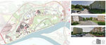
Image:Nature conservation.jpg|Valuable natural areas | |||
Image:Modlin_connectios_warszawa.jpg|Connectios with other cities | |||
Image:Modlin_description_1.jpg | |||
Image:Modlin_grenery_possibilities.jpg|Greenery possibilities | |||
Image:Modlin_built_environment.jpg|Built Environment | |||
Image:Modlin_gates.jpg|Gates of the Fortress | |||
Image:Modlin_typology.jpg | |||
Image:Modlin_typology_prewar.jpg|Typology Pre-war | |||
Image:Modlin_typology_postwar.jpg|Typology Post-war | |||
Image:Modlin_public_meeting.jpg|Meeting Points/Destinations | |||
Image:Modlin_destinations.jpg|Bufferzones of destinations, r:150m and 300m | |||
Image:Modlin_proposal.jpg|proposal | |||
</gallery> | </gallery> | ||
| Line 80: | Line 125: | ||
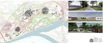
<gallery caption="Projective Drawings " widths="150px" heights="150px" perrow="4"> | <gallery caption="Projective Drawings " widths="150px" heights="150px" perrow="4"> | ||
Image: | Image:ROLNICTWO_MIEJSKIE.jpg|Urban farming | ||
Image: | Image:Modpark.jpg|City park (compatible with the combination of gates their connections) | ||
Image: | Image:Gates_slide.jpg|Connecting the city | ||
Image: | Image:Densifiying_modlin.jpg|Densifiying the city | ||
Image:P1_corridor.jpg|Corridor by river | |||
Image:P2_isolation_barrie.jpg|Isolation barrie | |||
Image:Template01.jpg|Ecotourism/Protection | |||
Image:Template02.jpg|Riverside Eco-Recreation | |||
</gallery> | </gallery> | ||
| Line 90: | Line 139: | ||
<gallery caption="Design Synthesis Drawings" widths="150px" heights="150px" perrow="4"> | <gallery caption="Design Synthesis Drawings" widths="150px" heights="150px" perrow="4"> | ||
Image: | Image:s.jpg|Strengths | ||
Image: | Image:ws.jpg|Weaknesses | ||
Image: | Image:op.jpg|Opportunities | ||
Image: | Image:tr.jpg|Threats | ||
Image:Modlin_master_plan.jpg|Master Plan | |||
</gallery> | </gallery> | ||
== Summary of the collaborative process == | == Summary of the collaborative process == | ||
During our collaborative process we successfully managed to develop the very first plans of redesigning the fortress and later introduce also new ideas. | |||
The area chosen by us is characterized by a huge GI potential, because of its specific values and also we can say, that it really requires the GI intervention due to the fact of both- disadvantages connected to the airport (noise, pollution) and existing infrastructure (fragmentation) and in the same time positives of those objects (airport- development of infrastructure and tourism, fortifications- cultural goods) . According to this, the biggest potential was minimizing negative effects, that the airport cases in the area as well as eliminating negative impact of division of the fortress zones by connecting it and improving general values of the object and life there, by using GI urban elements and developing buffer zones such as green corridor next to the riverside. | |||
We think, that the most difficult was in general working in the area as difficult as the Fortress of Modlin is; because of the age of the object, it's former destination and changes which were introduced there during the years, currently also the law limitations, the objects existing nowadays don't represent nothing like functionality or reasonable spatial development. Living there must be very uncomfortable, but everything can change with a bit of knowledge and imagination. | |||
By sharing our experience of different educational and cultural background we could learn from each other about new solutions or just extend our existing knowledge, what let us work on this pretty big scale object and focus on various aspects inside, and finally achieve our goal, which was the design of integrated area with GI elements. | |||
== Image Gallery == | == Image Gallery == | ||
| Line 103: | Line 160: | ||
<gallery caption="Image Gallery" widths="150px" heights="150px" perrow="4"> | <gallery caption="Image Gallery" widths="150px" heights="150px" perrow="4"> | ||
Image: | Image:Topview1942.jpg|fortress in 1942' | ||
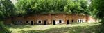
Image: | Image:Citadel.jpg|Citadele | ||
Image: | Image:Airportconstruction.jpg|Airport during contruction | ||
Image: | Image:Airport.jpg|Airport now | ||
Image:Spichlerz teraz.jpg|view at the granary | |||
Image:Bramy2.jpg|Gate | |||
Image:Modlinsa.jpeg|neglected building of fortress | |||
Image:Mur twierdzy.png|Canota wall | |||
Image:Bramy.jpg|bunkers | |||
</gallery> | </gallery> | ||
== References == | |||
http://natura2000.gdos.gov.pl/datafiles | |||
http://www.propertydesign.pl/architektura/104/twierdza_modlin_odzyje_konkurs_architektoniczny_w_2015,2580.html | |||
== | http://pl.wikipedia.org/wiki/Nowy_Dw%C3%B3r_Mazowiecki | ||
http://www.twierdzamodlin.nsk.pl/en/galeria/stare-zdjcia.html?page=1&catpage=1 | |||
http://nowy_dwor_mazowiecki.fotopolska.eu/454425,foto.html | |||
http://pl.wikipedia.org/wiki/Nizina_Mazowiecka#Klimat | |||
http://www.bryk.pl/wypracowania/geografia/geografia_spo%C5%82eczno_ekonomiczna/11139-kr%C3%B3tki_opis_regionu_mazowsza.html | |||
http://mapy.geoportal.gov.pl/imap/?gpmap=gp0&actions=acShowServices_KATASTER&locale=en | |||
http://wyborcza.pl/1,76842,15191703,Rolnictwo_przenosi_sie_do_miast__Jak_dziala_miejska.html | |||
http://www.zs14.edu.pl/olimpiada-modlin.pdf | |||
Wincenty Okołowicz: Strefy klimatyczne. W: Atlas geograficzny. [Oprac. red. Henryk Górski, Wanda Jędrzejewska ; red. map: Zofia Cukierska et al]. PPWK Warszawa, Wrocław 1990, Wydanie 23 | |||
Janusz Stasiak, Zbigniew Zaniewicz: Geografia. Vademecum maturalne. Wydawnictwo Pedagogiczne „Operon”, Gdynia cop. 2006. | |||
Latest revision as of 22:38, 25 January 2015
---> back to group page working group B
Modlin Fortress and its surroundings as a GI potential area
| Name | Modlin Fortress | |||||||||||
| Location | Modlin (near Warsaw) | |||||||||||
| Country | Poland | |||||||||||
| Authors | add author | |||||||||||

| ||||||||||||
| {{#widget:GoogleMaps | width=300 | height=240 | lat=52.4384554 | lng=20.674233 | zoom=12 | centermarker=yes | maptypecontrol=yes | overviewmapcontrol=yes | largemapcontrol=yes | scalecontrol=yes
}} | ||
Landscape and/or urban context of your case
- Biogeography
The area is situated in Eurosiberian region, in east-central Europe and from geomorphological point of view it's Middle European Plain, Masovian Lowland. It means, that the the relief of the terrain in this place is almost flat, rich in very developed river network. The medium altitude of the area is 127,6 m above the see level. Modlin is a district of Nowy Dwór Mazowiecki, located in east-central Poland, in Masovian Lowland. The climate of Masovian lowland is transitional climate between maritime and continental climate. As a resoult in the region there is pretty high temperature amplitude (in a scale of year), mostly during the winter season (2°C to -2°C). In the summer the average temperature is balanced, around 18 °C - 18,5 °C. The atmospheric precipitation level here is the lowest in the country and usually it's less than 500 mm during the year scale. Although soils here are rather poor- mostly podzols- nearby big rivers (so where Modlin Fortress is located) it's easy to find fertile alluvial soils. Despite the fact, that in most of Masovian Province area woods have been replaced by urban structures or transformed into Pinus monocultures, in the surroundings of Modlin still wilderness and various woods exist.
Flora and fauna existing in the area: according to document done towards the needs of Professional Geodety School, I've collected information about species existing in the sourroundings of the airport. Most common vegetation is trees such as: Acer sp, Betula sp, Corylus sp, Crataegus sp, Picea sp, Pinus sp, Populus sp, Prunus sp, Quercus sp, Sanbucus nigra sp, Tilia sp. With other plants mostly we can find there: Lupinus sp, Silybum marianum, Solidago sp, Tanacetum vulgare, Urtica dioica. The most important fauna in the area are birds - many endangered species and species connected to water habitats.
- Urban context: history and dynamics
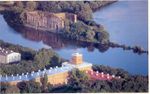
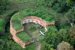
The location of Modlin at the confluence of Vistula, Narew and Wkra rivers was bringing to the place outstanding defensive qualities. Napoleon Bonaparte, during extending his impact on Eastern Europe, created Duchy of Warsaw and built serie of fortresses in its area. One of them was Modlin Fortress, which was started in 1806. According to his plan, the internal circuit of today's citadel was formed. The stronghold was created from earth and wood, with 5 bastions and the shape of semicircle, opened to the river.
After the Napoleon's period, the fortress has been occupied by Russian army. Russians have extended the area of fortress with an external perimeter, which was based on the shape of "crowns" of the internal bastion and consisted six fronts. In 1864 the complex of barracks was built, the citadel and the external circuit have been surrounded by the wall, called the Carnot. Im 1883 another reconstruction started- the Tsar's Army decided to build the "chain" of forts surrounding the fortress. This 8 forts are made of earth and bricks, and its length is 30 km, they are creating the first ring of forts. Similar modernization has been done in 1914, when the second ring of forts appeared. They created 10 additional forts, using concrete and steal.
87 years later, already after the I World War in December 1918 the Modlin Fortress has been taken by Polish Army.
In the interwar period Corps of Cadets stationed in Modlin. There was also Armored Training Center, with the Cadets School and the School of Officers, and also Sapper Training Centre. During next years the complex has been used for military goals, after the II World War the object still has been used by Polish Army as a training area etc.
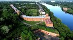
Nowadays The Modlin Fortress isn't anymore strategic military point. It became a historical monument, with it's well preserved buildings which are attracting many tourists.
- Overall character and cultural features
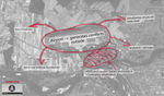
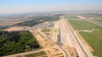
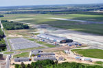
Nowadays, during the urban sprawl the space between internal and external perimeter of the fortress is partly occupied by housing estates and urban infrastructures. The significant object is an international airport, located just on the border of Modlin Fortress, which for sure is important social and cultural aspect overall, but obviously has a huge ( not always positive) influence on the ecology of the region and the quality of life of local citizens. The area in general is open, but with the historical buildings the situation is different - only some of them are open to the public and people can visit them with the guide, the rest is getting destroyed with the time and acts of vandalism. The terrain of the fortress is subject of conservation officer's care and in spite of the fact, that last year it was bought by private investor, the conservator needs to agree for all the proposed changes. There is a permission of adapting buildings of the main part (citadel) to new functions such as apartments, office space, but there is also condition: not to change overall exterior appearance of the buildings and to keep educational function by reserving part of the fortress for a museum. However labour on renovation of the object will need many changes in underground infrastructure such as connection to canalization, electricity and so on. Also with another extension of urban zone, there will be a necessity of creation social spots, such as parks, public squares and infrastructure connected to this. Fortunately in the area, inside the buildings of citadel and in the area between two perimeters of the fortress, there is a lot of greenery which can be easly adapted to new functions.
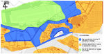
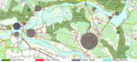
- Localization and structure of Modlin Fortress
-
 Localization of the study case
 -
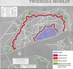 Explanation of fortress structure
 -
 Conflicts
 -
 Potentials
 -
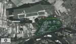
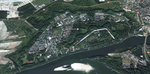 aerial picture: vegetation visible on circuits and forts


What are the overall objectives of your design? What are the specific objectives for enhancing green infrastrucutre?
Overall objective of this integrated design is connecting existing urban structures with historical elements in the way it'll be well adapted to new functions, makes area attractive and involves ideas positively working on ecological and cultural aspects of the place.
- creation of places with organized greenery (parks, gardens)
- facilities for citizens - f.ex. designing parkings
- improving connectivity between both circuits of the fortress and surrounding area and accessibility to historical objects
- provide access to the riverside and creation of attractive boulevards
- adaptation of historical objects to new functions - f.x embankments might transform into paths with view points dor interesting objects.
- protection and preservation the historical objects
All of mentioned ideas can include GI elements.
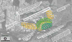
The objective of enhancing green infrastructure is minimizing the negative influence of the airport on local and surrounding areas, like problem of noise, pollution (air, soil, water), the ground water level disturbance and in general all the factors which can have bad impact on fauna, flora and quality of humans life in the region. Also there is plan of reducing artificial isolation within the fortress area.
- Plantation plans including high noise damping and pollution storing vegetation in surroundings of the airport
- Plantation plans including biofiltration species in the surroundings of the airport
- Plantation plans providing biodiversity of the place
- Resumption of lost habitats
- Rainwater management strategy and storage elements
- Proper adaptation of the circuits of fortifications and embankments, reduction of isolation
- GI elements in the urban environment: urban agriculture and health pathways in newly planned housing estimate in citadel
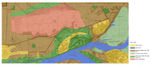
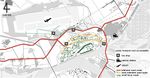
Analytical drawings
Please add four analytical sketches/drawings (or montages/schemes) of your case. Every group member needs to contribute at least one drawing.
- Analytical Drawings
-
 Overall look of the place
 -
 Use of land
 -
 Accessibility and public communication
 -
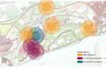
 Possibility of using GI
 -
 Problem of izolation
 -
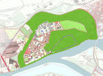
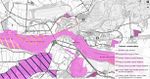 Valuable natural areas
 -
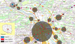 Connectios with other cities
 -
-
 Greenery possibilities
 -
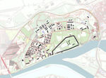 Built Environment
 -
 Gates of the Fortress
 -
-
 Typology Pre-war
 -
 Typology Post-war
 -
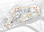
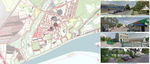 Meeting Points/Destinations
 -
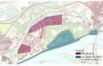
 Bufferzones of destinations, r:150m and 300m
 -
 proposal


Projective drawings
Please add four projective sketches/drawings (or montages/schemes), of course with an emphasis on green infrastructure aspects. Every group member needs to contribute at least one drawing representing his/her individual ideas.
- Projective Drawings
-
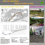 Urban farming
 -
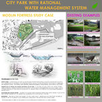 City park (compatible with the combination of gates their connections)
 -
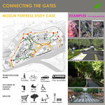 Connecting the city
 -
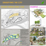 Densifiying the city
 -
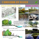 Corridor by river
 -
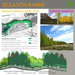 Isolation barrie
 -
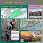 Ecotourism/Protection
 -
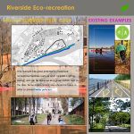 Riverside Eco-Recreation


Design Synthesis
Please analyse the individual approaches presented so far and evaluate their strengths and weaknesses (you may use the SWOTanalysis model). Try to create a synthesis and represent it with a plan and some sketches. You can still use drawings/sketches.
- Design Synthesis Drawings
-
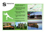 Strengths
 -
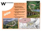 Weaknesses
 -
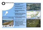 Opportunities
 -
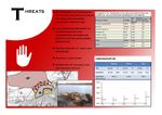 Threats
 -
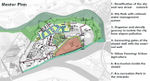 Master Plan


Summary of the collaborative process
During our collaborative process we successfully managed to develop the very first plans of redesigning the fortress and later introduce also new ideas.
The area chosen by us is characterized by a huge GI potential, because of its specific values and also we can say, that it really requires the GI intervention due to the fact of both- disadvantages connected to the airport (noise, pollution) and existing infrastructure (fragmentation) and in the same time positives of those objects (airport- development of infrastructure and tourism, fortifications- cultural goods) . According to this, the biggest potential was minimizing negative effects, that the airport cases in the area as well as eliminating negative impact of division of the fortress zones by connecting it and improving general values of the object and life there, by using GI urban elements and developing buffer zones such as green corridor next to the riverside.
We think, that the most difficult was in general working in the area as difficult as the Fortress of Modlin is; because of the age of the object, it's former destination and changes which were introduced there during the years, currently also the law limitations, the objects existing nowadays don't represent nothing like functionality or reasonable spatial development. Living there must be very uncomfortable, but everything can change with a bit of knowledge and imagination.
By sharing our experience of different educational and cultural background we could learn from each other about new solutions or just extend our existing knowledge, what let us work on this pretty big scale object and focus on various aspects inside, and finally achieve our goal, which was the design of integrated area with GI elements.
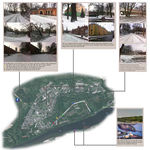
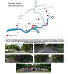
Image Gallery
You may add a series of images/photos in addition to the sketches/drawings
- Image Gallery
-
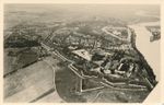 fortress in 1942'
 -
 Citadele
 -
 Airport during contruction
 -
 Airport now
 -
 view at the granary
 -
 Gate
Gate -
 neglected building of fortress
 -
 Canota wall
 -
 bunkers


References
http://natura2000.gdos.gov.pl/datafiles
http://pl.wikipedia.org/wiki/Nowy_Dw%C3%B3r_Mazowiecki
http://www.twierdzamodlin.nsk.pl/en/galeria/stare-zdjcia.html?page=1&catpage=1
http://nowy_dwor_mazowiecki.fotopolska.eu/454425,foto.html
http://pl.wikipedia.org/wiki/Nizina_Mazowiecka#Klimat
http://mapy.geoportal.gov.pl/imap/?gpmap=gp0&actions=acShowServices_KATASTER&locale=en
http://wyborcza.pl/1,76842,15191703,Rolnictwo_przenosi_sie_do_miast__Jak_dziala_miejska.html
http://www.zs14.edu.pl/olimpiada-modlin.pdf
Wincenty Okołowicz: Strefy klimatyczne. W: Atlas geograficzny. [Oprac. red. Henryk Górski, Wanda Jędrzejewska ; red. map: Zofia Cukierska et al]. PPWK Warszawa, Wrocław 1990, Wydanie 23
Janusz Stasiak, Zbigniew Zaniewicz: Geografia. Vademecum maturalne. Wydawnictwo Pedagogiczne „Operon”, Gdynia cop. 2006.
About categories: You can add more categories with this tag: "", add your categories