Collaborative Green Infrastructure Design Group H: Difference between revisions
No edit summary |
|||
| (24 intermediate revisions by 4 users not shown) | |||
| Line 33: | Line 33: | ||
== Landscape and/or urban context of your case == | == Landscape and/or urban context of your case == | ||
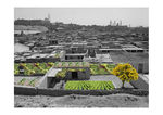
AlAzhar park is considered to be the green lung inside a very dense and crowded Metropolitan area of Cairo city, it was built on an old landfill site and designed to be a very attractive monument of the capital. | |||
The most interesting thing about this park that its completely surrounded by grey infrastructure from all directions with no green connectivity whatsoever to any existing park or even natural area, even the near castle or the ElMokattam Hill situated inside Cairo city, which makes it an ideal starting point of establishing a green infrastructure in the surrounding of the park to the city borders. In addition to the fact that this park has a very high number of plant species and water features (though most are artificial) rendering it to be an ecological center of the city and the heart of the first steps of a green infrastructure that can be constructed through the city. | |||
== What are the overall objectives of your design? What are the specific objectives for enhancing green infrastructure? == | |||
The city of Cairo is full with history, beautiful buildings and a beautiful park, wich represents the biggest green area in the city. The park is surrounded by grey building and is isolated from other green area. The purpose of this design is to connect green areas, to create new ones, to use water in a sustainable and economical way and to make people communicate more with each other. | |||
== Analytical drawings == | == Analytical drawings == | ||
<gallery caption="Analytical Drawings " widths="150px" heights="150px" perrow="4"> | <gallery caption="Analytical Drawings " widths="150px" heights="150px" perrow="4"> | ||
Image: | Image:Plansa1.jpg|The need of more green areas | ||
Image: | Image:Park analysis.jpg|Park analysis | ||
Image: | Image:Surrounding neighborhood analysis.jpg|Surrounding neighborhood analysis | ||
Image: | Image:Topographic map.jpg|Topographic map | ||
Image:Analytical Drawings GRW.jpg|Roof farming, green roofs and walls | |||
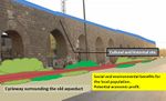
Image:A_DA.jpg|connection via cycle path | |||
</gallery> | </gallery> | ||
== Projective drawings == | == Projective drawings == | ||
<gallery caption="Projective Drawings " widths="150px" heights="150px" perrow="4"> | <gallery caption="Projective Drawings " widths="150px" heights="150px" perrow="4"> | ||
Image: | Image:Green infrastructure evelopement concept.jpg|projective drawing 4 | ||
Image: | Image:Plansa2.jpg|The concept of a woonerf | ||
Image: | Image:Projective Drawing GRW 2.jpg|Greener Better | ||
Image: | Image:P_DA.jpg|cycle path alongside greenery | ||
</gallery> | </gallery> | ||
== Design Synthesis == | == Design Synthesis == | ||
<gallery caption="Design Synthesis Drawings" widths="150px" heights="150px" perrow="4"> | <gallery caption="Design Synthesis Drawings" widths="150px" heights="150px" perrow="4"> | ||
Image: | Image:Swot_AlAzhar_Park.jpg|Swot analysis | ||
Image: | Image:Gi Page 2.jpg|Options 1 and 2 of smart water usage | ||
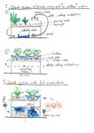
Image: | Image:Gi Page 1.jpg|Option 3 of smart water usage | ||
</gallery> | </gallery> | ||
== Summary of the collaborative process == | == Summary of the collaborative process == | ||
The potential of introducing greens spaces in the monotone color of urban buildings will bring positive outcome in so many ways. Also bringing back to live the old aqueduct and reusing/recycling water will give a significant push in the way of greener Cairo. | |||
Most difficult was that most of us lack the sense of the environment in Cairo. Not knowing the range and the capacity of water supplement restrained us form foreseeing the possible obstacles. For the green roofs, in general we couldn’t have known the accessibility and the construction limitations of the building. So three options were suggested for the smart use of water in which all are of a closed system of water usage; Soiless closed water system for plants and fruit production, plant and fish production closed system and the closed system of water usage in cooling temperature of the building (acting as an ecological air conditioners). | |||
Collaborative design means solution to a problem viewed form different eyes, contributing to more clear observation of the problems and more accurate resolutions. As contributing to the project, the team work helps the individual development of the team members. | |||
== Image Gallery == | == Image Gallery == | ||
<gallery caption="Image Gallery" widths="150px" heights="150px" perrow="4"> | <gallery caption="Image Gallery" widths="150px" heights="150px" perrow="4"> | ||
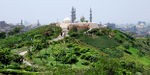
Image: | Image:Main axis high ground view.jpg|Main axis high ground view | ||
Image: | Image:view of historical city.jpg|view of historical city | ||
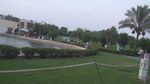
Image: | Image:Restaurants.jpg|Restaurants | ||
Image: | Image:Greenary.JPG|Greenary | ||
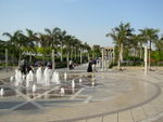
Image:Open spaces.JPG|Open spaces | |||
Image:Artificial lake.JPG|Artificial lake | |||
Image:Islamic style.JPG|Moorsih/Islamic design style | |||
Image:Top.JPG|Local topography | |||
</gallery> | </gallery> | ||
== References == | |||
- Al-Azhar park, Cairo and the revitalisation of Darb Al-Ahmar, 2005 | |||
- Egyptian Ministry of tourism website | |||
- Google earth inc. | |||
- Green infrastcure online seminar, 1st lecture by Peter Wilder | |||
- Hanz Zaydel, 2009 "The project of transforming roofs into fruit production gardens" | |||
Latest revision as of 08:14, 23 February 2015
---> back to group page working group H
ALAZHAR PARK
| Name | AlAzhar park and surrounding neighborhood | |||||||||||
| Location | Cairo | |||||||||||
| Country | Egypt | |||||||||||
| Authors | Abdullah Arafa, Anna Martínez, Deleanu Florina, Martin Antonov | |||||||||||

| ||||||||||||
| {{#widget:GoogleMaps | width=300 | height=200 | lat=30.0409685 | lng=31.265254099999993 | zoom=15 | centermarker=yes | maptypecontrol=yes | overviewmapcontrol=yes | largemapcontrol=yes | scalecontrol=yes
}} | ||
Landscape and/or urban context of your case
AlAzhar park is considered to be the green lung inside a very dense and crowded Metropolitan area of Cairo city, it was built on an old landfill site and designed to be a very attractive monument of the capital. The most interesting thing about this park that its completely surrounded by grey infrastructure from all directions with no green connectivity whatsoever to any existing park or even natural area, even the near castle or the ElMokattam Hill situated inside Cairo city, which makes it an ideal starting point of establishing a green infrastructure in the surrounding of the park to the city borders. In addition to the fact that this park has a very high number of plant species and water features (though most are artificial) rendering it to be an ecological center of the city and the heart of the first steps of a green infrastructure that can be constructed through the city.
What are the overall objectives of your design? What are the specific objectives for enhancing green infrastructure?
The city of Cairo is full with history, beautiful buildings and a beautiful park, wich represents the biggest green area in the city. The park is surrounded by grey building and is isolated from other green area. The purpose of this design is to connect green areas, to create new ones, to use water in a sustainable and economical way and to make people communicate more with each other.
Analytical drawings
- Analytical Drawings
-
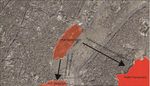
 The need of more green areas
 -
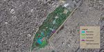 Park analysis
 -
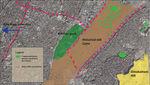 Surrounding neighborhood analysis
 -
 Topographic map
 -
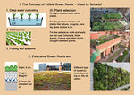 Roof farming, green roofs and walls
 -
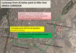 connection via cycle path


Projective drawings
- Projective Drawings
-
 projective drawing 4
 -
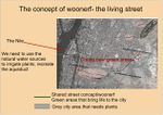
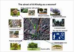 The concept of a woonerf
 -
 Greener Better
 -
 cycle path alongside greenery


Design Synthesis
- Design Synthesis Drawings
-
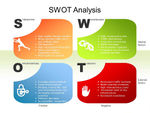 Swot analysis
 -
 Options 1 and 2 of smart water usage
 -
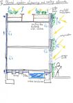 Option 3 of smart water usage


Summary of the collaborative process
The potential of introducing greens spaces in the monotone color of urban buildings will bring positive outcome in so many ways. Also bringing back to live the old aqueduct and reusing/recycling water will give a significant push in the way of greener Cairo.
Most difficult was that most of us lack the sense of the environment in Cairo. Not knowing the range and the capacity of water supplement restrained us form foreseeing the possible obstacles. For the green roofs, in general we couldn’t have known the accessibility and the construction limitations of the building. So three options were suggested for the smart use of water in which all are of a closed system of water usage; Soiless closed water system for plants and fruit production, plant and fish production closed system and the closed system of water usage in cooling temperature of the building (acting as an ecological air conditioners).
Collaborative design means solution to a problem viewed form different eyes, contributing to more clear observation of the problems and more accurate resolutions. As contributing to the project, the team work helps the individual development of the team members.
Image Gallery
- Image Gallery
-
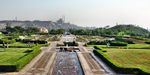 Main axis high ground view
 -
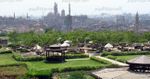 view of historical city
 -
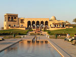 Restaurants
 -
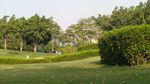 Greenary
 -
 Open spaces
 -
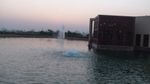 Artificial lake
 -
 Moorsih/Islamic design style
 -
 Local topography


References
- Al-Azhar park, Cairo and the revitalisation of Darb Al-Ahmar, 2005
- Egyptian Ministry of tourism website
- Google earth inc.
- Green infrastcure online seminar, 1st lecture by Peter Wilder
- Hanz Zaydel, 2009 "The project of transforming roofs into fruit production gardens"
About categories: You can add more categories with this tag: "", add your categories