Collaborative Design Planting Design Working Group 2: Difference between revisions
Rinijames11 (talk | contribs) |
|||
| (5 intermediate revisions by 2 users not shown) | |||
| Line 58: | Line 58: | ||
== What are the objectives of your design? == | == What are the objectives of your design? == | ||
- To '''revive and revitalize''' | - To '''revive and revitalize''' the site area and give it a '''new identity'''. | ||
- To '''analyse''' the scope of the site and project proposal while keeping in mind the '''usage pattern''' and possibilities. | - To '''analyse''' the scope of the site and project proposal while keeping in mind the '''usage pattern''' and possibilities. | ||
| Line 113: | Line 113: | ||
Image:LANDFILLco.jpg|Synthesis drawing 1: Planting Strategy for the landfill areas. | Image:LANDFILLco.jpg|Synthesis drawing 1: Planting Strategy for the landfill areas. | ||
Image:Strater_dg1.jpg|Synthesis drawing 2 : Representing the current conditions of different areas in the chosen zone and also the strategy used to redesign. '''Concept''' : The walk through the woodlands culminate into the wetland, changing the habitat type and breaking the monotony.The reason to convert the area onto woodlands is because the surrounding patches have a dense foliage of trees. The pattern is continued to maintain uniformity and make the area rich in green. | Image:Strater_dg1.jpg|Synthesis drawing 2 : Representing the current conditions of different areas in the chosen zone and also the strategy used to redesign. '''Concept''' : The walk through the woodlands culminate into the wetland, changing the habitat type and breaking the monotony.The reason to convert the area onto woodlands is because the surrounding patches have a dense foliage of trees. The pattern is continued to maintain uniformity and make the area rich in green. | ||
</gallery> | Image:Biotope conceptual planting design.jpg|Biotope conceptual planting design: Biotope conceptual planting design | ||
Image:Proposed plant species Page 1.jpg|Proposed plant species Page 1 | |||
Image:Proposed plant species Page 2.jpg|PProposed plant species Page 2 | |||
</gallery>Proposed plant species Page 2 | |||
== Summary of the collaborative process == | == Summary of the collaborative process == | ||
| Line 126: | Line 129: | ||
''You may add a series of images/photos in addition to the sketches/drawings'' | ''You may add a series of images/photos in addition to the sketches/drawings'' | ||
<gallery caption="Image Gallery" widths=" | <gallery caption="Image Gallery" widths="230px" heights="230px" perrow="4"> | ||
Image:IMG_1243.JPG|Logistics centre adjoining the site | Image:IMG_1243.JPG|Logistics centre adjoining the site | ||
Image:IMG_1260.JPG|Image showing traffic and visibility aspects on Autobahn A73 | Image:IMG_1260.JPG|Image showing traffic and visibility aspects on Autobahn A73 | ||
| Line 132: | Line 135: | ||
Image:IMG 1239.JPG|Caravan onsite indicative camping actives | Image:IMG 1239.JPG|Caravan onsite indicative camping actives | ||
Image:IMG_1295.JPG|Sharp topographic shifts | Image:IMG_1295.JPG|Sharp topographic shifts | ||
Image:IMG_1260.JPG|Site as visible from Autobahn A73 | |||
Image:IMG_1268.JPG|Landfill area adjoining the site | |||
Image:IMG_1291.JPG|Sand dunes that have formed overtime | |||
</gallery> | </gallery> | ||
Latest revision as of 20:29, 18 February 2014
---> back to group page working group 2
Please add the title of your case study here, adjust the map coordinates and replace the moa image with a characteristic image of your site
| Name | Project Biotope | |||||||||||
| Location | Forchheim | |||||||||||
| Country | Germany | |||||||||||
| Authors | Abdullah Arafa,Evelina Knyzelyte,Rini James | |||||||||||

| ||||||||||||
| {{#widget:GoogleMaps | width=300 | height=200 | lat=49.69009 | lng=11.05685 | zoom=15 | centermarker=yes | maptypecontrol=yes | overviewmapcontrol=yes | largemapcontrol=yes | scalecontrol=yes
}} | ||
Landscape and/or urban context of your case
LOCATION : The site of "Project Biotope" is located along the autobahn A73 towards Forchheim, Germany. Apart from the many farms and fields, the most predominant public green space in the city of Forchheim is the StadtPark (City park). The city also consists of considerable amount of forest cover. Overall, Forchheim is located in in the lower terrace of the Rhine valley and has a fertile and arable land.
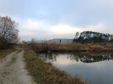
SITE HISTORY : This site served as a landfill for construction debris like bricks,stones,sand,etc from local and neighbouring construction and demolition sites. With excessive dumping the land was close to exploited and needed supervision and this intentness created a demand among private investors which led to encroachment and soon a logistics centre was set up in one part of the site. Eventually, the state took measures to guard a part of the site which is yet unexploited and took an initiative to conserve this area by transforming it into a BIOTOPE (specifically an amphibian reserve).The existing conditions in the undisturbed parts of the site are extremely conducive to transform this less prominent area into a potential 'lung space' for the region.
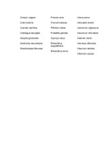
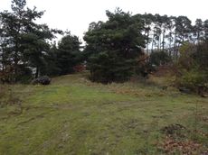
BIOGEOGRAPHY : The undisturbed parts of the site is rich in vegetation and the ever changing local conditions show new plant species shooting up in various parts of the site. While the most dominant species of trees on site are ‘Acer cappadocicum’ ‘Betula pendula’ ‘Pinus Strobus’ ‘Betula Pendula’ and the ground cover is predominantly ‘Molinia caerulea’ and ‘Juncus effusus’ , exactly one or two shoots of ‘Verbascum thapsus’ and a couple of other species are seen thriving.
The site terrain which was relatively flat has self-modulated with time, forming sand dunes and deep trenches dramatizing the experience on site. The sandunes, are believed to be a result of dispersal of sand by wind from the landfill part of the site.Existing water bodies are also home to some aquatic creatures like fish and toads.
DYNAMICS : The site is sometimes used by private owners for camping or rented out for campers. The area encroached to be used as landfill has minimized in size after the proposal to revitalize the area. This acreage is not an identified piece of land but it is prominently located and possesses innate abilities to transform itself into a dignified landscape.
OVERALL : Favourable existing site conditions (soil/vegetation) and the site setting shows optimism in the project proposal. This could establish a cultural connect which is currently non existent in the site vicinity.
- widths=
-
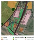 Illustration 1 :Site Vicinity
 -
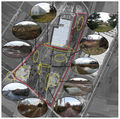 Illustration 2 : View of different parts of the site
 -
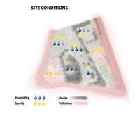
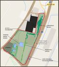 Illustration 3 : Site Details


What are the objectives of your design?
- To revive and revitalize the site area and give it a new identity.
- To analyse the scope of the site and project proposal while keeping in mind the usage pattern and possibilities.
- Understanding the urban context and its influence on the project at a micro and macro level and vice-versa.
- Explore various typologies of 'Biotopes' in the existing site condition and create a mixed habitat.
- To explore new plant species along with the already existing foliage on site.
- To establish a cultural context and create a landmark in the region.
- To use the site as an interactive domain to connect nature and people.
- To create an educative and recreational landscape while keeping interventions minimal.
- To add a green corridor along the Autobahn and strengthen the character of the site and region overall.
Analytical drawings
Please add four analytical sketches/drawings (or montages/schemes) of your case. Every group member needs to contribute at least one drawing.
- Analytical Drawings
-
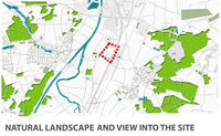 Natural landscape in the region and visual axis into the site
 -
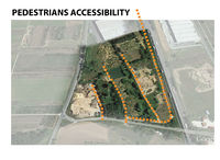 Existing pedestrian access into the site
 -
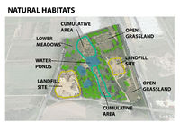 Classification of different physical conditions existing on site
 -
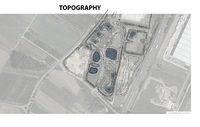 Topographic analysis
 -
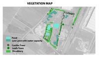 Prevalent vegetation
 -
 Climate and Physical influences
 -
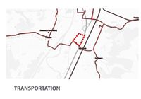 Transport network connecting the site


Projective drawings
Please add four projective sketches/drawings (or montages/schemes), of course with an emphasis on planting design/vegetation aspects. Every group member needs to contribute at least one drawing representing his/her individual ideas.
- Projective Drawings
-
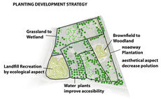 Zoning indicating planting strategy
 -
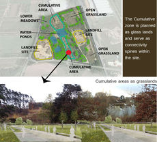 Cumilative zones on site are replaced with grasslands
 -
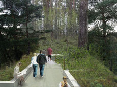 The existing brownfield area converted into woodlands. Public accessibility into all the proposed zones are provided to establish an interactive platform between people and nature.
 -
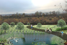 Grassland revived into wetland due to the water retention capacity of the soil in that region. This would aid growth of aquatic plants and amphibians and other aquatic life. Hence serving as a good platform for a closer association with nature and also for recreational use.


Design Synthesis
The Planting scheme and design proposal for the project are analyzed in the form of SWOT charts and also illustrations. The proposal is along the lines of a ‘Biotope’, with additional zoning to create a diverse habitat within the same setting. The site conditions prove conducive to support a Biotope that is versatile in its capacity.
Design interventions on the other hand, are kept minimal to retain the innate characteristics of the site setting. Basic physical additions to establish a public connect to the site is carried out and supplementary local plant species that can be supported on site are added along with the existing. Also, the well vegetated part of the site was kept undisturbed and only the chunk that had immense potential but deteriorated was considered (as illustrated in the drawings).
- Design Synthesis Drawings
-
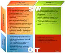 SWOT chart 1 : Overall Planning Strategy
 -
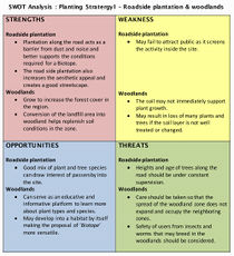 SWOT chart 2 : Planting Strategy and planning proposed : Roadside plantation and Woodlands.
 -
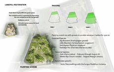 Synthesis drawing 1: Planting Strategy for the landfill areas.
 -
 Synthesis drawing 2 : Representing the current conditions of different areas in the chosen zone and also the strategy used to redesign. Concept : The walk through the woodlands culminate into the wetland, changing the habitat type and breaking the monotony.The reason to convert the area onto woodlands is because the surrounding patches have a dense foliage of trees. The pattern is continued to maintain uniformity and make the area rich in green.
 -
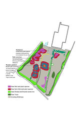 Biotope conceptual planting design: Biotope conceptual planting design
 -
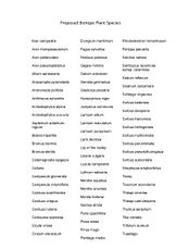 Proposed plant species Page 1
 -
 PProposed plant species Page 2


Proposed plant species Page 2
Summary of the collaborative process
Individual analysis of the project proposal and a collective discussion thereafter led to ideas that were acceptable to all. Although, at an individual level certain ideas were felt more staunchly towards, they were implemented subtly in the strategy. The varying backgrounds of the three authors i.e. Architecture, Agriculture and Landscape architecture gave good opportunity to understand the same case in different perspectives. It was rather interesting to see how the focus area or interests vary influenced by one’s professional background. This collaborative process was also an opportunity to see how all the different perspectives can be put together to arrive at a satisfying solution that looks solitary. In our project, the strategy remained simple. The site was zoned keeping in mind ‘Planting Design’ concepts while considering local and urban issues. Projectives were worked out collectively for the same. In addition, it was clearly a learning experience of not only the subject but also communication, analytical abilities, time management and commitment while maintaining a stainless relationship within the group.
Image Gallery
You may add a series of images/photos in addition to the sketches/drawings
- Image Gallery
-
 Logistics centre adjoining the site
 -
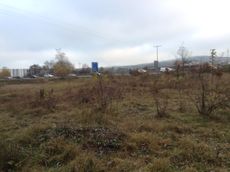 Image showing traffic and visibility aspects on Autobahn A73
 -
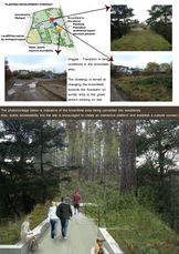
 Ares on site with good vegetation.The image is also indicative of change in physical differences in terms of topography,ground cover,foliage,etc.This creates a dual landscape effect coupled in the same acreage.
 -
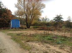 Caravan onsite indicative camping actives
 -
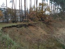 Sharp topographic shifts
 -
Site as visible from Autobahn A73
-
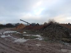 Landfill area adjoining the site
 -
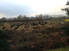 Sand dunes that have formed overtime


References
* Please make sure that you give proper references of all external resources used.
NOTE : This Project is undocumented.The referred sources are as acknowledged below. The photomontages are a compilation of bits of images.
https://maps.google.de/maps?q=St2244,+Forchheim&ie=UTF-8&ei=SGaeUpOuC8eMtAb0yoGYCA&ved=0CAoQ_AUoAg
Büro Czerwonka,Erlangen & open sources for montage image gallery
About categories: You can add more categories with this tag: "", add your categories