Collaborative Design Planting Design Working Group 3: Difference between revisions
| (6 intermediate revisions by 2 users not shown) | |||
| Line 110: | Line 110: | ||
== Analytical drawings == | == Analytical drawings == | ||
<gallery caption="Analytical Drawings " widths="150px" heights="150px" perrow="5"> | <gallery caption="Analytical Drawings " widths="150px" heights="150px" perrow="5"> | ||
| Line 121: | Line 120: | ||
== Projective drawings == | == Projective drawings == | ||
<gallery caption="Projective Drawings " widths="150px" heights="150px" perrow="5"> | <gallery caption="Projective Drawings " widths="150px" heights="150px" perrow="5"> | ||
| Line 137: | Line 135: | ||
*'''''Connection issue''' is the most important concept. So, we are connecting between urban fabric and Metropolitan Park through Bicentennial Park. | *'''''Connection issue''' is the most important concept. So, we are connecting between urban fabric and Metropolitan Park through Bicentennial Park. | ||
1. Connecting urban fabric with park by creating urban green pedestrian corridors through existing street and public nodes inside urban fabric and put park gates to welcome people who come through these corridors. | 1. Connecting urban fabric with park by creating urban green pedestrian corridors through existing street and public nodes inside urban fabric and put park gates to welcome people who come through these corridors. | ||
2. Connecting river & park to improved ecology by extending lagoons to river, and removing the road (transfer traffic to another urban side), create pedestrian path along the river. Also, we allowing the park green to naturally spread along the direction of the river. | |||
3. Connecting Metropolitan Park area “the Hill” with park by adding bridges to allow people moving between park plazas and Metropolitan Park, and adding tunnels to allow animals moving between two sides. | 2. Connecting river & park to improved ecology by extending lagoons to river, and removing the road (transfer traffic to another urban side), create pedestrian path along the river. Also, we allowing the park green to naturally spread along the direction of the river. | ||
- So, urban nodes connecting with park by urban green corridors which connect with park plaza and river to Metropolitan Park. | |||
3. Connecting Metropolitan Park area “the Hill” with park by adding bridges to allow people moving between park plazas and Metropolitan Park, and adding tunnels to allow animals moving between two sides. | |||
-So, urban nodes connecting with park by urban green corridors which connect with park plaza and river to Metropolitan Park. | |||
*''Our '''intervention design''' are : | *''Our '''intervention design''' are : | ||
1. Keeping the boulevard as pedestrian path which contain park gates that connect with urban fabric. This boulevard provides good views to the park. | 1. Keeping the boulevard as pedestrian path which contain park gates that connect with urban fabric. This boulevard provides good views to the park. | ||
2. Create organic main pedestrian path with plazas in bridges interactions | |||
3. Grass areas between boulevard and main path. These Grass areas with shadow trees for different activities. | 2. Create organic main pedestrian path with plazas in bridges interactions | ||
4. Splitting the slope to small hills which provide good views inside park and to Metropolitan Park. | |||
5. Adding a third lagoon to improved diversity in the park, it is also a good way to alter the microclimate. | 3. Grass areas between boulevard and main path. These Grass areas with shadow trees for different activities. | ||
6. South lagoon could be used for more cultural activities to get more familiar with dynamic of the lagoons by Toy boats, Amphitheaters, Stepped seating, Touch pools.'' | |||
4. Splitting the slope to small hills which provide good views inside park and to Metropolitan Park. | |||
5. Adding a third lagoon to improved diversity in the park, it is also a good way to alter the microclimate. | |||
6. South lagoon could be used for more cultural activities to get more familiar with dynamic of the lagoons by Toy boats, Amphitheaters, Stepped seating, Touch pools.'' | |||
| Line 162: | Line 168: | ||
== Summary of the collaborative process == | == Summary of the collaborative process == | ||
*The collaborative process was a true learning experience for all of us. | *The collaborative process was a true learning experience for all of us. Nishtha and Leslie are architects and Mohammed is Landscape architect and from totally different parts of the world. The park itself was designed by an architectural firm and that made it interesting for us to work upon. We had a good base to begin with. We were lucky to have Leslie on site almost every other day, with new inputs to give, altering our approaches as well! | ||
*All our approaches still | *All our approaches still focused mainly around the issue of connecting Bicentennial Park to metropolitan park areas; through vegetation, pathways, green bridges, tunnels. This seemed to be the most obvious requirement for the site given the proximity and yet the disconnect between the two areas. Diverting some of the vehicular traffic was a joint issue here. Secondly, we focused on improving micro-climate and inducing more cultural activities. Both of these were done to give fuel to people to come to the park more often! The green nodes, spreading into the city's urban fabric helps introduce the park even before its real boundaries begin. | ||
== Image Gallery == | == Image Gallery == | ||
<gallery caption="Image Gallery" widths="150px" heights="150px" perrow="4"> | <gallery caption="Image Gallery" widths="150px" heights="150px" perrow="4"> | ||
| Line 180: | Line 185: | ||
== References == | == References == | ||
*http://www.plataformaarquitectura.cl/ | *http://www.plataformaarquitectura.cl/ | ||
Latest revision as of 13:52, 29 January 2014
---> back to group page working group 3
Bicentennial Park, Santiago, Chile
| Name | Bicentennial Park | |||||||||||
| Location | Av. Bicentenario 3800, Vitacura, Santiago | |||||||||||
| Country | Chile | |||||||||||
| Authors |
Leslie Iturra, Mohammed Alkhanbashi, Nishtha Bali | |||||||||||

| ||||||||||||
| {{#widget:GoogleMaps | width=300 | height=200 | lat=-33.398915 | lng=-70.601971 | zoom=13 | centermarker=yes | maptypecontrol=yes | overviewmapcontrol=yes | largemapcontrol=yes | scalecontrol=yes
}} | ||
Landscape and/or urban context of your case
BIOGEOGRAPHY
Total area: 314.314 sq. m. green area
Paths: 6 km of pedestrian paths; 3,2 km of bike ways
Vegetation: 4.000 trees which are native species 1.300
Native Trees:
- Bellotos: Protected specie, endangered, heights of 15 meters
- Pataguas: Heights of 10 meters, white flowers
- Peumos: Heights of 25 meters, red edible fruit
- Quillay: Heights of 20 meters, green/White flowers
- Arrayán: Endangered, heights of 4 meters, cream color flowers, yellow fruit
- Chilean Palm: Partially protected, heights of 25 meters, edible nuts
- Espinos: Heights of 5-6 meters, yellow flowers
Non native species:
- Holm oak (Encina): Mediterranean region, heights of 16-25 meters
- Oriental plane (plátano oriental): Eastward from the Balkans, heights of 30 meters or more
- Cockspur Coral Tree (Ceibo): From Argentina , Uruguay, Southern Brazil and Paraguay, heights of 5- 8 meters, red flowers
- Jacaranda: From Central America, south America, Cuba Hispanoila and The Bahamas, heights of 20-30 meters, purple-blue flowers
- Lagerstroemia indica (crespón): China, Korea, Japan and Indian Subcontinent, heights of 6 meters, white, pink mauve, purple or carmine flowers
- Sweetgum (liquidambar): heights of 25-40 meters
- Cork Oak (alcornoque): From Europe and northwest of Africa, heights of 20 meters
- Bald Cypress (ciprés calvo): From USA, heights of 25- 40 meters
- Mexican fan palm (palma washintoniana): From Western Sonora and Baja California in Mexico. heights of 25 meters, white flowers
- Parkinsonia: From semi-desert of Africa and America, heights of 5 -12 meters, yellow and white flowers
Lagoons: 2 artificial lagoons
Wildlife: In the north lagoon live different kind of birds such as Chilean Flamingo, Black-necked Swan, Koi Fish and the followings have migrated to the park: Great Egret (Garza blanca) and White Winged Coot(Tagua)
CULTURAL FEATURES
The aim of the design was to provide a mix of public and administrative activity. In the park area are public activities in general and also administrative in the Municipality Building. The park seeks to preserve some native Chilean plant species and so these were included in the design of the park. Different park features are:
- Ramps of access, which joins the street and the park (for reasons of privacy and visual continuity, the park is under level of the street).
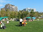
- Central esplanade; the place where the most of activities occur. In this area is the pedestrian way to go along the park and the place to rest in the lawn or play in the playground, as well as special areas for children and pets. Also it is 2 lagoons the north one is reserved for the wild life by hosting different types of birds and fishes and the south one is reserved to play with toy boats. The mass-activities has its place also in a little amphitheatre and a esplanade beside the Municipality Building. The spiritual life is placed in a little oratory situated between the esplanade and the building.
- The slope: which is a visual and acoustic screen that protect the park of the highway (and separates the park of the river) and create a lookout along the park.
OVERALL CHARACTER
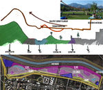
The "Parque Bicentenario" (Bicentennial Park) is situated on the shore of the only river that crosses Santiago, and in the past few years has turned from an empty piece of land (which is part of a Metropolitan Park zoning in Santiago) to a beautiful and peaceful park. This park has become in a good quality green area in Santiago with 24.000 visitors per year. It under level street design allows privacy and works as a refuge and also facing the Metropolitan park, which is a hill inside the city, gives to this park a sensation of continuity.
HISTORY and DYNAMICS
Before being intervened this zone was a vulnerable point in the city between a highway and a residential area (Despite being one of the more wealthy residential areas in the city) this condition meant that the rest of the land around it was affected for this non-use area. Nowadays we can see the results here, and see this park as an example of how residual areas of a city can be joined to the city and also give value to a zone.
- CONTEXT
-
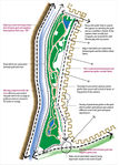
 Aerial View of the Area
 -
 Normative Context
 -
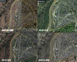 View along time
 -
 Park Scheme


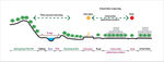
What are the objectives of your design?
We have a good foundation to work with and we would like build upon this by trying to:
- Connect the park to its surrounding park areas, like the Metropolitan Park area etc. This will help provide a good view to the hill and create connection solutions between ecological zones and human activities.
- Trying to make the river as a part of our park, or at least connect it to the park. This will serve an ecological purpose, by attracting more animal and bird species to the park and also explore its aesthetic potential. In this sense the river would be used like lagoons too, making it possible to use water as an ornamental element.
- If, we are able to connect the river to the park well, we could even look at the river as a resource, be it for irrigation or energy. Including the shore of the river along its path will help connect the park with the rest of the park system along the river, in this way the design will join the river, Bicentennial Park and the rest of the city in a park system.
- Design green bridges to connect the Bicentennial park with the hill, in this way the visual connection achieve to become in real connection, allowing to visitors traverse the river and walking from one side of the city to the other.
All of this would in turn encourage the interaction between the park and the urban fabric. This way urban green corridors could be introduced in Santiago and these could be used for social activities and of course, make it a more sustainable environment.
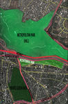
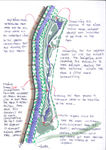
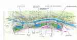
Analytical drawings
- Analytical Drawings
-
 Park Areas
 -
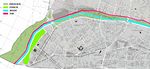
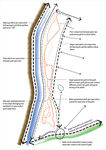 Traffic & Paths Layer
 -
 Vegetation & Water Layer
 -
 Visual Layer
 -
 All Layers and Conclusion


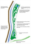
Projective drawings
- Projective Drawings
-
 Vegetation and Water
 -
 South Lagoon
 -
 Traffic and paths connections
 -
 Section for Traffic and paths connections
 -
 Park Intervention


Design Synthesis
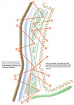
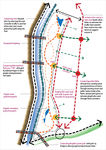
- After our individual projection drawings, we evaluate these concepts by using SWOT analysis method to create combined synthesis conceptual plan.
- We consider concepts which we all agree with it. We use strengthens points in our SWOT analysis in our combined plan. Also, we avoid the weakness points.
- Connection issue is the most important concept. So, we are connecting between urban fabric and Metropolitan Park through Bicentennial Park.
1. Connecting urban fabric with park by creating urban green pedestrian corridors through existing street and public nodes inside urban fabric and put park gates to welcome people who come through these corridors.
2. Connecting river & park to improved ecology by extending lagoons to river, and removing the road (transfer traffic to another urban side), create pedestrian path along the river. Also, we allowing the park green to naturally spread along the direction of the river.
3. Connecting Metropolitan Park area “the Hill” with park by adding bridges to allow people moving between park plazas and Metropolitan Park, and adding tunnels to allow animals moving between two sides.
-So, urban nodes connecting with park by urban green corridors which connect with park plaza and river to Metropolitan Park.
- Our intervention design are :
1. Keeping the boulevard as pedestrian path which contain park gates that connect with urban fabric. This boulevard provides good views to the park.
2. Create organic main pedestrian path with plazas in bridges interactions
3. Grass areas between boulevard and main path. These Grass areas with shadow trees for different activities.
4. Splitting the slope to small hills which provide good views inside park and to Metropolitan Park.
5. Adding a third lagoon to improved diversity in the park, it is also a good way to alter the microclimate.
6. South lagoon could be used for more cultural activities to get more familiar with dynamic of the lagoons by Toy boats, Amphitheaters, Stepped seating, Touch pools.
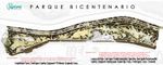
- Design Synthesis Drawings
-
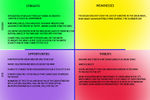 SWOT: Vegetation and Paths
 -
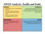 SWOT: Traffic and Paths
 -
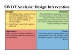 SWOT: 'Design Intervention'
 -
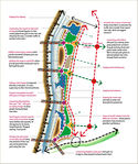 Combined synthesis conceptual plan
 -
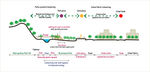 Combined synthesis Section


Summary of the collaborative process
- The collaborative process was a true learning experience for all of us. Nishtha and Leslie are architects and Mohammed is Landscape architect and from totally different parts of the world. The park itself was designed by an architectural firm and that made it interesting for us to work upon. We had a good base to begin with. We were lucky to have Leslie on site almost every other day, with new inputs to give, altering our approaches as well!
- All our approaches still focused mainly around the issue of connecting Bicentennial Park to metropolitan park areas; through vegetation, pathways, green bridges, tunnels. This seemed to be the most obvious requirement for the site given the proximity and yet the disconnect between the two areas. Diverting some of the vehicular traffic was a joint issue here. Secondly, we focused on improving micro-climate and inducing more cultural activities. Both of these were done to give fuel to people to come to the park more often! The green nodes, spreading into the city's urban fabric helps introduce the park even before its real boundaries begin.
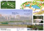
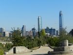
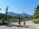
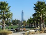
Image Gallery
- Image Gallery
-
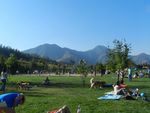 Near Municipality building, looking east
 -
 Near Municipality Building, looking west
 -
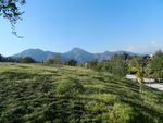 View of slope between river and park
 -
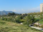 View of park from slope
 -
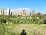 View from Municipality Building
 -
 Typical pathway
 -
 Park entry near Municipality Building
 -
 Benches and Trees


References
- http://www.plataformaarquitectura.cl/
- http://www.vitacura.cl/
- http://www.minube.net/photos/place/130394/623451
- http://www.thisischile.cl/5745/2/213/more-green-space-for-santiago-residents-at-bicentennial-park/Article.aspx
About categories: You can add more categories with this tag: "", add your categories