Parque de Educação Ambiental Professor Mello Barreto: Difference between revisions
| (171 intermediate revisions by 3 users not shown) | |||
| Line 17: | Line 17: | ||
| '''Project costs''' || style="background:Lavender"|''Please enter the costs (if known)'' | | '''Project costs''' || style="background:Lavender"|''Please enter the costs (if known)'' | ||
|- | |- | ||
| colspan="3" align="center" style="background:silver"| [[Image: | | colspan="3" align="center" style="background:silver"| [[Image:Parque Mello Barreto 2b.jpg|300px]] | ||
|- | |- | ||
| ||style="background:Lavender"| | | ||style="background:Lavender"| | ||
| Line 29: | Line 29: | ||
=== Rationale: Why is this case study interesting? === | === Rationale: Why is this case study interesting? === | ||
[[Image:MB4a.jpg|300px|thumb|left|Architect Fernando Chacel with visitors in the Professor Mello Barreto Nature Education Park]] | |||
* The author of this project is the architect Fernando Chacel, one of the most important landscape | * The author of this project is the architect Fernando Chacel, one of the most important landscape architects in Brazil, with more than 50 years of experience. He was Roberto Burle Marx's trainee in the 50's. | ||
* The project shows how a natural and protected area that suffered the impact of an illegal occupation can be restored through the called “ecogenesis”. | * The project shows how a natural and protected area that suffered the impact of an illegal occupation can be restored through the so-called “ecogenesis”. According to the botanic Luiz Emygdio de Mello Filho ”the idea of ecogenesis as the main purpose of man’s creation of substitute ecosystems for degraded or lost ecosystems as result of human interventions" stems from the 40’s. It was proposed by team members of the National Museum and has perfectly adjusted to the country’s socioenvironmental reality. It is therefore essential that these anthropic substitute ecosystems, though different from the original ones, maintain, preserve and convey to future generations the values they once sustained so that they may endure in the environment reality. | ||
According the botanic Luiz Emygdio de Mello Filho ”the idea of ecogenesis as the main purpose of man’s creation of substitute ecosystems for degraded or lost ecosystems as result of human interventions stems from the 40’s. It was proposed by team members of the National Museum and has perfectly adjusted to the country’s socioenvironmental reality. It is therefore essential that these anthropic substitute ecosystems, | |||
=== Author's perspective === | === Author's perspective === | ||
* | * The Professor Mello Barreto Nature Education Park is an example for big cities who have difficulties combining big urban development with nature conservation. As an architect from a big city I believe that this project brings hope to city people who want to live with nature despite the aggressive urbanization. | ||
=== Description === | === Description === | ||
*Rio de Janeiro is the second biggest city of Brazil, with more than 6 million people in an area of 1200 km2. The Professor Mello Barreto Nature Education Park is located in Barra da Tijuca, around the Jacarepagua Lagoon. | |||
The park was financed through a local community (Acibarra) that wanted to recuperate the degraded area and guarantee the protection of the Lagoon-Margin Protection Belt. | * Rio de Janeiro is the second biggest city of Brazil, with more than 6 million people in an area of 1200 km2. The Professor Mello Barreto Nature Education Park is located in Barra da Tijuca, around the Jacarepagua Lagoon, in an area of 50'000 m2. | ||
* The park was financed through a local community (Acibarra) that wanted to recuperate the degraded area and guarantee the protection of the Lagoon-Margin Protection Belt. | |||
* The restoration of the area where the park is today was executed through an innovative idea of “ecogenesis”: recuperation of a biological landscape through the utilization of association and individuals of the original ecosystems. | |||
<gallery caption=" " widths="200px" heights="200px" perrow="2"> | |||
Image:BR-sat.jpg|Brazil, Rio de Janeiro | |||
Image:RJ-sat1.jpg|Rio de Janeiro, Lagoa da Tijuca | |||
</gallery> | |||
=== Landscape and/or urban context=== | === Landscape and/or urban context=== | ||
Situated on a peninsula around the Jacarepagua Lagoon, surrounded by the Atlantic Rainforest of Rio de Janeiro, the area is in the Tijuca Lagoon-Margin Protection Belt, covered by a good | [[Image:Overview_of_the_lagoon_before_park_installation.jpg|thumb|300px|left|View from the lagoon]] | ||
[[Image:Barra2.jpg|thumb|300px|right|View of Barra da Tijuca area]] | |||
* Situated on a peninsula around the Jacarepagua Lagoon, surrounded by the Atlantic Rainforest of Rio de Janeiro where the Tijuca National Park is located, the area is in the Tijuca Lagoon-Margin Protection Belt, covered by a good sized mangrove before it was illegally occupied. Today in the park the vegetation and mangrove have both regenerated. | |||
* Until the 1980's, the area of Tijuca was almost uninhabitated because the difficult access. Despite the urbanization plans from early 1970's this area began to develop years later with the new highways and tunnels. Consequently the area grew fast and disorderly, disturbing the until then preserved ecosystem. The neighborhood Barra da Tijuca is currently inhabited by a richer society in contrast with the poor population of ''favelas''. Many shoppings malls and rich commerce dominate the area that still grows with immense enterprises. | |||
* The Park is an answer to the recuperation of the mangrove ecosystem into the Lagoon-Margin Protection Belt. The whole landfill that landed the mangroves during the years of destruction was used to build the park which is situated in a higher level. | |||
=== Cultural/social/political context=== | === Cultural/social/political context=== | ||
In the 1970's, this area, which is twenty times bigger than downtown Rio, was empty and difficult to access. Just in the 70's, when the access was improved, big companies began buying land for a very low price to build for the rich people. At the same time the poor population that worked on the construction, built their "favelas" around, which also contributed to the destruction of the ecosystem as they threw immense amounts of trash into the lagoon. | |||
During | During construction of the big luxurious buildings around the lagoon, the mangroves were cleared. The ecosystem was almost totally destroyed. Although the area is regarded to be a permanently preserved area by the Brazilian constitution, the government didn't interfere. | ||
After some years, the area got value and the | After some years, the area got value and the ''favelas'' turned into an inconvenient for the rich population and for the traders. The simple removal of this population would be against human rights but the permanent accusation of ecological degradation “helped” them to accuse the ''favelas'' as being responsible for the destruction, which served as an excuse to remove them. | ||
To avoid the forced removal of this poor population, a local community (Acibarra), | To avoid the forced removal of this poor population, a local community (Acibarra), lead by a lawyer, started a project of environmental education for the people about the importance of the mangrove ecosystem for the fauna and for the quality of human life. The community could convince the population to move back their constructions from the Lagoon-Margin Protection Belt and to replant the local vegetation. Despite all the efforts during two years and the new mentality, the government and the builders didn’t care and decided to move the ''favelas'' away through violence. In 1994 the ''favelas'' were all completely removed. | ||
The local community and the government dislocated the population to a new popular houses complex nearby, specially built to shelter them. | The local community and the government dislocated the population to a new popular houses complex nearby, specially built to shelter them. | ||
Once the area was reclaimed | Once the area was reclaimed as public domain, the municipal government and private enterprises again joined forces to recuperate the Lagoon-Margin Protection Belt, under the supervision of the Municipal Environmental Protection Agency. Today, the Professor Mello Barreto Nature Education Park occupies this area. | ||
<gallery caption=" " widths="500px" heights="200px" perrow="2"> | |||
Image:ocupaçao_1.jpg|Landscape disturb because of the illegal occupation | |||
Image:ocupaçao_2.jpg|Degradation of the area | |||
</gallery> | |||
=== History === | |||
* The implementation of a project according the ecogenesis principles was something new despite that its ideas come from the 40's. | |||
* In 1969 the architect Lúcio Costa reflected on the future of the Tijuca area, where the park is located. He could already see that if the area continues to be developed without protection, it would be totally destroyed, losing the entire original ecosystem. He wanted to find a way to reconcile urbanization with protection and conservation of natural ecosystems. The idea of sustainability was already there. | |||
[[Image:Lucio Costa.jpg|thumb|300px|left|Architect Lucio Costa's urbanistic plan for Barra da Tijuca area, 1969]] | |||
* After three years, in 1972 during the Stockholm Conference, the principles of sustainability were discussed. For the first time was the danger of developing without preserving the environmental basis was alerted to the authorities. This was the first time the concept of sustainable development was discussed. | |||
* One year later, in 1973 in Brasília, the government created the Environment Secretariat. The environmental laws were developed but stayed on the papers, because the military government had an interest in innovative ideas of sustainable development. | |||
* Only in 1986 with the end of the military regime did the government make the National Consul of Environment obligatory through the First Resolution in the country the Environmental Impact Study and the Environmental Impact Report. | |||
* Since then, the landscape projects turn a deed into the in the Environmental Impact Study as compensatory action or to mitigate procedure. The goal is to recuperate or recreate the destroyed ecosystems in the affected natural landscape. The idea of ecogenesis, the recuperation of damaged ecosystems with the human intervention, comes from here. | |||
* In 1992 with the ECO-92, environmental questions are discussed again specifically those regarding the sustainable development. In the same year the first biosphere reserve was created in Brazil, in the Atlantic Rainforest. One year later in 1993, the area of Tijuca where the park is, turned into an Area of Environmental Protection. All new projects in the area are required to follow severe laws of natural protection based on all sustainable development principles from this moment forward. | |||
[[Image:Time line.jpg]] | |||
=== Spatial analysis of area/project/plan=== | === Spatial analysis of area/project/plan=== | ||
[[Image:MB-Projeto.jpg|thumb|300px|left|Project concept]] | |||
* The park is situated in the Lagoon-Margin Protection Belt around the Jacarepagua Lagoon, along one kilometer of a seven kilometer long area that involves the Via Parque. | |||
* The project process involved: | * The project process involved: | ||
1. Recuperation of the mangrove forest. | 1. Recuperation of the mangrove forest - purification of the water, collecting the garbage, reproduction with the surviving mangroves. | ||
2. Recreation of a substitution ecosystem. | 2. Recreation of a substitution ecosystem - information about the native plants of this ecosystem for the substitution process. | ||
3. Restructuration of the mangrove forest and the restinga vegetation (vegetation of a salty and sandy land near by the sea) with native flora. | 3. Restructuration of the mangrove forest and the restinga vegetation (vegetation of a salty and sandy land near by the sea) with native flora. | ||
4. Education through the park – the visitors can appreciate and learn about the Atlantic vegetation along the park ways. | 4. Education through the park – the visitors can appreciate and learn about the Atlantic vegetation along the park ways. The park involves the ''Jardim de Restinga'' (Restinga Garden), with plants of the ''restinga'' vegetation, the ''Jardim de Bromélias'' (Bromeliades Garden), with bromeliades, the ''Arboreto da Mata Atlântica'' (Atlantic Rainforest Tree Garden), with native trees of this ecosystem and the ''Bosque das Fruteiras'' (Fruit Wood) with fruit trees to attract birds and other animals. | ||
5. The park excludes any intensive use, like sport courts – the idea is to rest, | 5. The park excludes any intensive use, like sport courts – the idea is to rest, appreciate the nature along the ways and to learn from it. | ||
[[#toc|'''Back to top''']] | |||
=== Core Questions Working Group Nature Conservation / Water === | === Core Questions Working Group Nature Conservation / Water === | ||
==== What is the role of user groups? ==== | ==== What is the role of user groups? ==== | ||
The park is visited by | The park is visited by local people of all ages. The installations planned for the park include walkways and places to stop and rest. The idea is to invite the visitors to learn about the native plants through explanation signs along the beltway. Moreover there is a cycle path where the park meets the crest of the slope that separates it from the mangrove forest and an arena where visitors can gather or disperse (the only constructed element in the park), plus two piers for mooring small boots. The park is intended for extensive use. | ||
==== What is the role of the city? ==== | ==== What is the role of the city? ==== | ||
The park is situated in a peninsular position, bordering a newly created stretch of “Via Parque” (a highway built along the right side of Tijuca Lagoon, to guarantee a lagoon shoreline protection). The area where | The park is situated in a peninsular position, bordering a newly created stretch of “Via Parque” (a highway built along the right side of Tijuca Lagoon, to guarantee a lagoon shoreline protection). The area where of the park, Barra da Tijuca, is an area of expansion of Rio de Janeiro’s city that has increased since the 80’s. | ||
==== How do urban and natural structures interact? ==== | ==== How do urban and natural structures interact? ==== | ||
The landscape architect has instituted innovative design strategies that conserve areas of | The landscape architect has instituted innovative design strategies that conserve areas of original ecosystems of the coastal lagoons and restore other areas by mixing fragments of the original vegetation with new indigenous plantings. | ||
The idea is to integrate the restored area to the nature that surrounds the | The idea is to integrate the restored area to the nature that surrounds the entire city of Rio de Janeiro. This is a difficult task considering the city has the natural landscape as a strong characteristic which the landscape architectural work cannot compete with. The park proposal included a bromeliad garden and a sector dedicated to ''restinga'' species. For the first time in a public area of Rio de Janeiro one could see terrestrial orchids and species from the dunes and beach ridges. | ||
The project tried to organize | The project tried to organize plant associations according to the landscaping process, resembling the ''restingas'' which had been destroyed in this area. | ||
An arboretum of | An arboretum of atlantic rainforest species was planned for the park, even though this was a rather unconventional measure. Visitors could learn to recognize native species of this formation, which constitutes the Atlantic Rainforest Domain together with ''restingas'' and mangroves. | ||
The grounds are located at the land-water interface on Tijuca Lagoon | The grounds are located at the land-water interface on Tijuca Lagoon. On one front, which is considered to be a privileged site next to a lagoon, there is a good view of the surrounding panorama; and on the other, natural monuments such as the Tijuca Massif stand out from the landscape. | ||
==== What is the role of water? ==== | ==== What is the role of water? ==== | ||
The water’s | |||
[[Image:MB8a.jpg|thumb|300px|left|Mangroves in the park]] | |||
The water’s environmental balance is the most important factor in guaranteeing the life of the native species, especially for the mangroves. | |||
The illegal occupation on the area and the irregular construction of the new buildings had polluted the lagoon and destroyed the mangroves. | |||
With the implementation of the park, a large amount of trash was taken from the lagoon’s water thereby saving the ecosystem of the mangroves. | |||
==== What is the evolution of the urban relation between humans and nature? ==== | ==== What is the evolution of the urban relation between humans and nature? ==== | ||
| Line 119: | Line 150: | ||
The project shows how a natural and protected area that suffered the impact of an illegal occupation can be restored through the called “ecogenesis”. | The project shows how a natural and protected area that suffered the impact of an illegal occupation can be restored through the called “ecogenesis”. | ||
It is therefore essential that these anthropic substitute ecosystems, through different from the original ones, maintain, preserve and convey to the future the values they once sustained so that they may endure in the environment reality | It is therefore essential that these anthropic substitute ecosystems, through different from the original ones, maintain, preserve and convey to the future the values they once sustained so that they may endure in the environment reality | ||
[[#toc|'''Back to top''']] | |||
=== Analysis of program/function === | === Analysis of program/function === | ||
* What are the main functional characteristics? | * What are the main functional characteristics? | ||
The recuperation and preservation of the delicate ecosystem of the mangrove forest is the goal of the park. The walkways and rest areas exist to invite visitors to learn about the ecosystem as there are many park signs with explicative texts throughout the park. The purpose of the park is nature education. | |||
* How have they been expressed or incorporated? | * How have they been expressed or incorporated? | ||
The main function of the park is the protection of the local ecosystem. The creation of the park was the only way they found to preserve the area against the massive and aggressive expansion of the city which was completely destroying the mangrove forest. Through the park, the city can control the pollution and protect the water from being polluted by garbage. | |||
The park is linear around the lagoon - this green belt serves as a protection that separates the streets and houses from the lagoon area. | |||
=== Analysis of design/planning process === | === Analysis of design/planning process === | ||
[[Image:Draw_bromeliad_garden.jpg|thumb|300px|left|Draw of the bromeliad park]] | |||
* How was the area/project/plan formulated and implemented? | * How was the area/project/plan formulated and implemented? | ||
The project was formulated by the architect Fernando Chacel together with an interdisciplinary team. They started the project with an inventory of the landscape, analyzing each element within it. Physical, biotic and the anthropic aspects of this landscape and its inter-relations are observed. After gathering data, they established a program and a concept. Only after the concept came the first drafts. It was important in the beginning of the process to avoid formulating drafts as the initial prospective is fundamental to the success of the project. | |||
*Were there any important consultations/collaborations? | *Were there any important consultations/collaborations? | ||
The architect Fernando Chacel has a partnership with botanists, biologists, geomorphologists, forest engineers, agronomists, urbanists and other architects. | |||
=== Analysis of use/users === | === Analysis of use/users === | ||
* How is the area/project/plan used and by whom? | |||
* Is the use changing? Are there any issues? | [[Image:MB-Planta_esquematica2.jpg|thumb|300px|left|Plan of the park in a park sign]] | ||
* How is the area/project/plan used and by whom? | |||
The park is used by the local inhabitants and other visitors. It does not have any special relationship with special public or age groups. People go to walk, to ride a bicycle or to enjoy the atmosphere. The park is also a great opportunity for people who like nature and want to learn about the native vegetation of the area. Many park signs have explanations about the local fauna and flora. Naturally the park is also visited by many animals from the atlantic rainforest, species who had lost their habitat when the area was originally disturbed and developed. | |||
*Is the use changing? Are there any issues? | |||
The park has a stable and extensive use. The proposal of the park is to educate the visitors through ecological principles and ideas of preserving. | |||
=== Future development directions === | === Future development directions === | ||
[[Image:MB1a.jpg|thumb|300px|left|View to the lagoon]] | |||
* How is the area/project/plan evolving? | * How is the area/project/plan evolving? | ||
The future of the park depends on the ability to maintain its functions and on remaining an initial model from the whole lagoon-margin protection belt along the linear park “Via Parque”. Unfortunately the construction of the highway “Via Parque” didn’t follow the conceptions of the project – the vegetation was planted at random, without following the park principles. | |||
* Are there any future goals? | * Are there any future goals? | ||
The main goal of the park is to educate people about environmental principles. The future goals are to keep the park's status quo, to keep the park protected from future new occupations, to keep the park preserved, conserved in a good condition and naturally providing environmental education for the visitors. | |||
=== Peer reviews or critique === | === Peer reviews or critique === | ||
* Has the area/ project/plan been reviewed by academic or professional reviewers? | |||
[[Image:Contemporary_cover.jpg|thumb|300px|left|Book "Contemporary Garden Aesthetics, Creations and Interpretations"]] | |||
* Has the area/project/plan been reviewed by academic or professional reviewers? What were their main evaluations? | |||
The work of Fernando Chacel was deeply analyzed by the landscape architect Peter Jacobs (fellow of the American Society of Landscape Architects and professor of the University of Montreal) in the book “Contemporary Garden Aesthetics, Creations and Interpretations” (Conan, Harvard University Press, 2007) and in the magazine Landscape Architecture of May 2006. Chacel’s work is intensely praised because the ecological focus in the innovative idea of ecogenesis. The integration of a spreading city with more than 600 favelas (informal housing settlements) with its imposing nature is also Chacel’s challenge that is recognized with admiration. | |||
The magazine “Folia” is also a landscape architecture magazine from Italy that had an article about Chacel’s work in April 2000. | |||
=== Points of success and limitations === | === Points of success and limitations === | ||
* | |||
* Successes: The Flora was successful in reestablishing the park through the process of substitution called ecogenesis. Moreover the local social problem was solved – the illegal inhabitants were relocated to a relatively nearby area. | |||
* Limitations: Although the relocation of the people that occupied the area illegally represented a barrier, the main difficulty during the project was to find native species in the market. | |||
* Future limitations: The park must be conserved; it is difficult in a place with so many social, economical and political problems. Too often, nature is not considered important or relevant. | |||
In Brazil the idea of conservationism is still new and most people who are not well-educated cannot understand the importance of environmental conservation. | |||
=== What can be generalized from this case study? === | === What can be generalized from this case study? === | ||
[[Image:Ecogenesis.jpg|thumb|300px|left|Ecogenesis]] | |||
*Are there any important theoretical insights? | *Are there any important theoretical insights? | ||
The project of Prof. Mello Barreto Nature Education Park and other projects from Fernando Chacel in Barra da Tijuca follow the principles of ''ecogenesis''. The concept is not new, but from 1986 with the new laws, it made the execution of this kind of project possible. ''Ecogenesis'' is a process where ecosystems are recreated as biotic compensation for development impacts through landscape solutions. | |||
=== Which research questions does it generate? === | === Which research questions does it generate? === | ||
The project is used as a support for researchers through a creation of research applied on the materialization of the ecosystem of substitution. It adopts the principles of ''ecogenesis'' for degraded areas. | |||
This kind of intervention, once introduced, can turn the position of environmental public institutions strong enough to claim more projects like this using the substitution system. As a result, the market may be alerted as to the need for production of native flora by nurseries. Presently it is still difficult to find a variety of native plants for sale in the market, and the lack of variety of native plant species makes the realization of this kind of project more difficult. | |||
[[#toc|'''Back to top''']] | |||
=== Image Gallery === | === Image Gallery === | ||
<gallery caption=" " widths="150px" heights="150px" perrow="5"> | <gallery caption=" " widths="150px" heights="150px" perrow="5"> | ||
Image: | Image:Parque_Mello_Barreto_1.jpg|View from Prof.Mello Barreto Nature Education Park | ||
Image: | Image:MB6a.jpg|View of a walkway in the park | ||
Image: | Image:Parque_Mello_Barreto_8.jpg|Overview from the area before the installation | ||
Image: | Image:Parque_Mello_Barreto_6.jpg|Mangroves | ||
Image: | Image:MB1a.jpg|View to the lagoon | ||
Image: | Image:MB7a.jpg|View into the park | ||
Image: | Image:MB10a.jpg|Another walkway in the park | ||
Image: | Image:Earthwork_on_the_area.jpg|Earthwork on the area | ||
Image: | Image:Area_nearly_finished.jpg|Area nearly finished | ||
Image: | Image:View_of_the_park_with_mountains2.jpg|View of the park with mountains | ||
</gallery> | </gallery> | ||
[[#toc|'''Back to top''']] | |||
=== References === | === References === | ||
* References and fotos: CHACEL, Fernando Magalhães . '''Paisagismo e ecogênese''' . Rio de Janeiro: Frainha, 2001. Permitted use by the author. | |||
* Other references: CONAN, Michel . '''Contemporary Garden Aesthetics, Creation and Interpretations''' . Harvard University Press, 2007. | |||
* Maps of Brazil and Rio de Janeiro: MIRANDA, E.E. de; COUTINHO, A.C. (Coord.) . '''Brasil Visto do Espaço''' . Campinas: Embrapa Monitoramento por Satélite, 2004. Disponível em <http://www.cdbrasil.cnpm.embrapa.br> | |||
* Lucio Costa's plan image: COSTA, Lúcio . '''Lúcio Costa: Registro de uma vivência''' . São Paulo: Empresa das Artes, 1995. Disponível em <http://www.vitruvius.com.br> | |||
* Barra da Tijuca's Photo: Disponível em <http://rio.rj.gov.br> | |||
---- | ---- | ||
| Line 180: | Line 288: | ||
[[Category:Brazil]] | [[Category:Brazil]] | ||
[[Category:Working Group Nature Conservation]] | [[Category:Working Group Nature Conservation]] | ||
Latest revision as of 18:13, 30 January 2009
| Name | Parque de Educação Ambiental Professor Mello Barreto by Architect Fernando Chacel | |
| Place | Rio de Janeiro, Barra da Tijuca | |
| Country | Brazil | |
| Topic | Revitalisation of an illegal residential occupation area to a city park | |
| Author(s) | Juliana Aschwanden-Vilaça | |
| Completion | Please enter the date of completion | |
| Client | Please enter the client | |
| Project costs | Please enter the costs (if known) | |

| ||
| <googlemap version="0.9" lat="-22.997745" lon="-43.352909" type="satellite" zoom="13" width="300" height="300">
</googlemap> | ||
Rationale: Why is this case study interesting?

- The author of this project is the architect Fernando Chacel, one of the most important landscape architects in Brazil, with more than 50 years of experience. He was Roberto Burle Marx's trainee in the 50's.
- The project shows how a natural and protected area that suffered the impact of an illegal occupation can be restored through the so-called “ecogenesis”. According to the botanic Luiz Emygdio de Mello Filho ”the idea of ecogenesis as the main purpose of man’s creation of substitute ecosystems for degraded or lost ecosystems as result of human interventions" stems from the 40’s. It was proposed by team members of the National Museum and has perfectly adjusted to the country’s socioenvironmental reality. It is therefore essential that these anthropic substitute ecosystems, though different from the original ones, maintain, preserve and convey to future generations the values they once sustained so that they may endure in the environment reality.
Author's perspective
- The Professor Mello Barreto Nature Education Park is an example for big cities who have difficulties combining big urban development with nature conservation. As an architect from a big city I believe that this project brings hope to city people who want to live with nature despite the aggressive urbanization.
Description
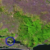
- Rio de Janeiro is the second biggest city of Brazil, with more than 6 million people in an area of 1200 km2. The Professor Mello Barreto Nature Education Park is located in Barra da Tijuca, around the Jacarepagua Lagoon, in an area of 50'000 m2.
- The park was financed through a local community (Acibarra) that wanted to recuperate the degraded area and guarantee the protection of the Lagoon-Margin Protection Belt.
- The restoration of the area where the park is today was executed through an innovative idea of “ecogenesis”: recuperation of a biological landscape through the utilization of association and individuals of the original ecosystems.
-
 Brazil, Rio de Janeiro
 -
 Rio de Janeiro, Lagoa da Tijuca


Landscape and/or urban context


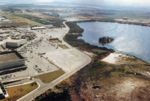
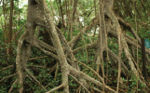
- Situated on a peninsula around the Jacarepagua Lagoon, surrounded by the Atlantic Rainforest of Rio de Janeiro where the Tijuca National Park is located, the area is in the Tijuca Lagoon-Margin Protection Belt, covered by a good sized mangrove before it was illegally occupied. Today in the park the vegetation and mangrove have both regenerated.
- Until the 1980's, the area of Tijuca was almost uninhabitated because the difficult access. Despite the urbanization plans from early 1970's this area began to develop years later with the new highways and tunnels. Consequently the area grew fast and disorderly, disturbing the until then preserved ecosystem. The neighborhood Barra da Tijuca is currently inhabited by a richer society in contrast with the poor population of favelas. Many shoppings malls and rich commerce dominate the area that still grows with immense enterprises.
- The Park is an answer to the recuperation of the mangrove ecosystem into the Lagoon-Margin Protection Belt. The whole landfill that landed the mangroves during the years of destruction was used to build the park which is situated in a higher level.
Cultural/social/political context
In the 1970's, this area, which is twenty times bigger than downtown Rio, was empty and difficult to access. Just in the 70's, when the access was improved, big companies began buying land for a very low price to build for the rich people. At the same time the poor population that worked on the construction, built their "favelas" around, which also contributed to the destruction of the ecosystem as they threw immense amounts of trash into the lagoon.
During construction of the big luxurious buildings around the lagoon, the mangroves were cleared. The ecosystem was almost totally destroyed. Although the area is regarded to be a permanently preserved area by the Brazilian constitution, the government didn't interfere. After some years, the area got value and the favelas turned into an inconvenient for the rich population and for the traders. The simple removal of this population would be against human rights but the permanent accusation of ecological degradation “helped” them to accuse the favelas as being responsible for the destruction, which served as an excuse to remove them.
To avoid the forced removal of this poor population, a local community (Acibarra), lead by a lawyer, started a project of environmental education for the people about the importance of the mangrove ecosystem for the fauna and for the quality of human life. The community could convince the population to move back their constructions from the Lagoon-Margin Protection Belt and to replant the local vegetation. Despite all the efforts during two years and the new mentality, the government and the builders didn’t care and decided to move the favelas away through violence. In 1994 the favelas were all completely removed. The local community and the government dislocated the population to a new popular houses complex nearby, specially built to shelter them.
Once the area was reclaimed as public domain, the municipal government and private enterprises again joined forces to recuperate the Lagoon-Margin Protection Belt, under the supervision of the Municipal Environmental Protection Agency. Today, the Professor Mello Barreto Nature Education Park occupies this area.
-
Landscape disturb because of the illegal occupation
-
Degradation of the area
History
- The implementation of a project according the ecogenesis principles was something new despite that its ideas come from the 40's.
- In 1969 the architect Lúcio Costa reflected on the future of the Tijuca area, where the park is located. He could already see that if the area continues to be developed without protection, it would be totally destroyed, losing the entire original ecosystem. He wanted to find a way to reconcile urbanization with protection and conservation of natural ecosystems. The idea of sustainability was already there.

- After three years, in 1972 during the Stockholm Conference, the principles of sustainability were discussed. For the first time was the danger of developing without preserving the environmental basis was alerted to the authorities. This was the first time the concept of sustainable development was discussed.
- One year later, in 1973 in Brasília, the government created the Environment Secretariat. The environmental laws were developed but stayed on the papers, because the military government had an interest in innovative ideas of sustainable development.
- Only in 1986 with the end of the military regime did the government make the National Consul of Environment obligatory through the First Resolution in the country the Environmental Impact Study and the Environmental Impact Report.
- Since then, the landscape projects turn a deed into the in the Environmental Impact Study as compensatory action or to mitigate procedure. The goal is to recuperate or recreate the destroyed ecosystems in the affected natural landscape. The idea of ecogenesis, the recuperation of damaged ecosystems with the human intervention, comes from here.
- In 1992 with the ECO-92, environmental questions are discussed again specifically those regarding the sustainable development. In the same year the first biosphere reserve was created in Brazil, in the Atlantic Rainforest. One year later in 1993, the area of Tijuca where the park is, turned into an Area of Environmental Protection. All new projects in the area are required to follow severe laws of natural protection based on all sustainable development principles from this moment forward.

Spatial analysis of area/project/plan

- The park is situated in the Lagoon-Margin Protection Belt around the Jacarepagua Lagoon, along one kilometer of a seven kilometer long area that involves the Via Parque.
- The project process involved:
1. Recuperation of the mangrove forest - purification of the water, collecting the garbage, reproduction with the surviving mangroves.
2. Recreation of a substitution ecosystem - information about the native plants of this ecosystem for the substitution process.
3. Restructuration of the mangrove forest and the restinga vegetation (vegetation of a salty and sandy land near by the sea) with native flora.
4. Education through the park – the visitors can appreciate and learn about the Atlantic vegetation along the park ways. The park involves the Jardim de Restinga (Restinga Garden), with plants of the restinga vegetation, the Jardim de Bromélias (Bromeliades Garden), with bromeliades, the Arboreto da Mata Atlântica (Atlantic Rainforest Tree Garden), with native trees of this ecosystem and the Bosque das Fruteiras (Fruit Wood) with fruit trees to attract birds and other animals.
5. The park excludes any intensive use, like sport courts – the idea is to rest, appreciate the nature along the ways and to learn from it.
Core Questions Working Group Nature Conservation / Water
What is the role of user groups?
The park is visited by local people of all ages. The installations planned for the park include walkways and places to stop and rest. The idea is to invite the visitors to learn about the native plants through explanation signs along the beltway. Moreover there is a cycle path where the park meets the crest of the slope that separates it from the mangrove forest and an arena where visitors can gather or disperse (the only constructed element in the park), plus two piers for mooring small boots. The park is intended for extensive use.
What is the role of the city?
The park is situated in a peninsular position, bordering a newly created stretch of “Via Parque” (a highway built along the right side of Tijuca Lagoon, to guarantee a lagoon shoreline protection). The area where of the park, Barra da Tijuca, is an area of expansion of Rio de Janeiro’s city that has increased since the 80’s.
How do urban and natural structures interact?
The landscape architect has instituted innovative design strategies that conserve areas of original ecosystems of the coastal lagoons and restore other areas by mixing fragments of the original vegetation with new indigenous plantings.
The idea is to integrate the restored area to the nature that surrounds the entire city of Rio de Janeiro. This is a difficult task considering the city has the natural landscape as a strong characteristic which the landscape architectural work cannot compete with. The park proposal included a bromeliad garden and a sector dedicated to restinga species. For the first time in a public area of Rio de Janeiro one could see terrestrial orchids and species from the dunes and beach ridges. The project tried to organize plant associations according to the landscaping process, resembling the restingas which had been destroyed in this area.
An arboretum of atlantic rainforest species was planned for the park, even though this was a rather unconventional measure. Visitors could learn to recognize native species of this formation, which constitutes the Atlantic Rainforest Domain together with restingas and mangroves.
The grounds are located at the land-water interface on Tijuca Lagoon. On one front, which is considered to be a privileged site next to a lagoon, there is a good view of the surrounding panorama; and on the other, natural monuments such as the Tijuca Massif stand out from the landscape.
What is the role of water?

The water’s environmental balance is the most important factor in guaranteeing the life of the native species, especially for the mangroves. The illegal occupation on the area and the irregular construction of the new buildings had polluted the lagoon and destroyed the mangroves. With the implementation of the park, a large amount of trash was taken from the lagoon’s water thereby saving the ecosystem of the mangroves.
What is the evolution of the urban relation between humans and nature?
1996, Landscape Architect: Fernando Chacel, Client: ACIBARRA (Commercial and Industrial Association of Barra da Tijuca)
The project shows how a natural and protected area that suffered the impact of an illegal occupation can be restored through the called “ecogenesis”. It is therefore essential that these anthropic substitute ecosystems, through different from the original ones, maintain, preserve and convey to the future the values they once sustained so that they may endure in the environment reality
Analysis of program/function
- What are the main functional characteristics?
The recuperation and preservation of the delicate ecosystem of the mangrove forest is the goal of the park. The walkways and rest areas exist to invite visitors to learn about the ecosystem as there are many park signs with explicative texts throughout the park. The purpose of the park is nature education.
- How have they been expressed or incorporated?
The main function of the park is the protection of the local ecosystem. The creation of the park was the only way they found to preserve the area against the massive and aggressive expansion of the city which was completely destroying the mangrove forest. Through the park, the city can control the pollution and protect the water from being polluted by garbage. The park is linear around the lagoon - this green belt serves as a protection that separates the streets and houses from the lagoon area.
Analysis of design/planning process

- How was the area/project/plan formulated and implemented?
The project was formulated by the architect Fernando Chacel together with an interdisciplinary team. They started the project with an inventory of the landscape, analyzing each element within it. Physical, biotic and the anthropic aspects of this landscape and its inter-relations are observed. After gathering data, they established a program and a concept. Only after the concept came the first drafts. It was important in the beginning of the process to avoid formulating drafts as the initial prospective is fundamental to the success of the project.
- Were there any important consultations/collaborations?
The architect Fernando Chacel has a partnership with botanists, biologists, geomorphologists, forest engineers, agronomists, urbanists and other architects.
Analysis of use/users

- How is the area/project/plan used and by whom?
The park is used by the local inhabitants and other visitors. It does not have any special relationship with special public or age groups. People go to walk, to ride a bicycle or to enjoy the atmosphere. The park is also a great opportunity for people who like nature and want to learn about the native vegetation of the area. Many park signs have explanations about the local fauna and flora. Naturally the park is also visited by many animals from the atlantic rainforest, species who had lost their habitat when the area was originally disturbed and developed.
- Is the use changing? Are there any issues?
The park has a stable and extensive use. The proposal of the park is to educate the visitors through ecological principles and ideas of preserving.
Future development directions

- How is the area/project/plan evolving?
The future of the park depends on the ability to maintain its functions and on remaining an initial model from the whole lagoon-margin protection belt along the linear park “Via Parque”. Unfortunately the construction of the highway “Via Parque” didn’t follow the conceptions of the project – the vegetation was planted at random, without following the park principles.
- Are there any future goals?
The main goal of the park is to educate people about environmental principles. The future goals are to keep the park's status quo, to keep the park protected from future new occupations, to keep the park preserved, conserved in a good condition and naturally providing environmental education for the visitors.
Peer reviews or critique

- Has the area/project/plan been reviewed by academic or professional reviewers? What were their main evaluations?
The work of Fernando Chacel was deeply analyzed by the landscape architect Peter Jacobs (fellow of the American Society of Landscape Architects and professor of the University of Montreal) in the book “Contemporary Garden Aesthetics, Creations and Interpretations” (Conan, Harvard University Press, 2007) and in the magazine Landscape Architecture of May 2006. Chacel’s work is intensely praised because the ecological focus in the innovative idea of ecogenesis. The integration of a spreading city with more than 600 favelas (informal housing settlements) with its imposing nature is also Chacel’s challenge that is recognized with admiration. The magazine “Folia” is also a landscape architecture magazine from Italy that had an article about Chacel’s work in April 2000.
Points of success and limitations
- Successes: The Flora was successful in reestablishing the park through the process of substitution called ecogenesis. Moreover the local social problem was solved – the illegal inhabitants were relocated to a relatively nearby area.
- Limitations: Although the relocation of the people that occupied the area illegally represented a barrier, the main difficulty during the project was to find native species in the market.
- Future limitations: The park must be conserved; it is difficult in a place with so many social, economical and political problems. Too often, nature is not considered important or relevant.
In Brazil the idea of conservationism is still new and most people who are not well-educated cannot understand the importance of environmental conservation.
What can be generalized from this case study?

- Are there any important theoretical insights?
The project of Prof. Mello Barreto Nature Education Park and other projects from Fernando Chacel in Barra da Tijuca follow the principles of ecogenesis. The concept is not new, but from 1986 with the new laws, it made the execution of this kind of project possible. Ecogenesis is a process where ecosystems are recreated as biotic compensation for development impacts through landscape solutions.
Which research questions does it generate?
The project is used as a support for researchers through a creation of research applied on the materialization of the ecosystem of substitution. It adopts the principles of ecogenesis for degraded areas. This kind of intervention, once introduced, can turn the position of environmental public institutions strong enough to claim more projects like this using the substitution system. As a result, the market may be alerted as to the need for production of native flora by nurseries. Presently it is still difficult to find a variety of native plants for sale in the market, and the lack of variety of native plant species makes the realization of this kind of project more difficult.
Image Gallery
-
 View from Prof.Mello Barreto Nature Education Park
 -
 View of a walkway in the park
 -
 Overview from the area before the installation
 -
 Mangroves
 -
 View to the lagoon
 -
 View into the park
 -
 Another walkway in the park
 -
 Earthwork on the area
 -
 Area nearly finished
 -
 View of the park with mountains


References
- References and fotos: CHACEL, Fernando Magalhães . Paisagismo e ecogênese . Rio de Janeiro: Frainha, 2001. Permitted use by the author.
- Other references: CONAN, Michel . Contemporary Garden Aesthetics, Creation and Interpretations . Harvard University Press, 2007.
- Maps of Brazil and Rio de Janeiro: MIRANDA, E.E. de; COUTINHO, A.C. (Coord.) . Brasil Visto do Espaço . Campinas: Embrapa Monitoramento por Satélite, 2004. Disponível em <http://www.cdbrasil.cnpm.embrapa.br>
- Lucio Costa's plan image: COSTA, Lúcio . Lúcio Costa: Registro de uma vivência . São Paulo: Empresa das Artes, 1995. Disponível em <http://www.vitruvius.com.br>
- Barra da Tijuca's Photo: Disponível em <http://rio.rj.gov.br>