Group Q - Collaborative Climate Adaption Project: Difference between revisions
No edit summary |
|||
| (123 intermediate revisions by 4 users not shown) | |||
| Line 75: | Line 75: | ||
=== Cultural/social/political context=== | === Cultural/social/political context=== | ||
'''Culture''' | '''Culture''' | ||
[[File:Karachi districts.PNG|300px|thumb|right|Administrative districts of Karachi]] | |||
Krokola was the ancient name of Karachi what literally means „a place where crocodile worship“. Around 1558, Karachi was a conglomerate of fishing villages, called Kalachi or Kalati, and in 1729, Seth Bhoju Mal laid foundation of a small township on the left bank of Lyari River. Town was recognized for commerce in the period of the Kalhora princess in 1793. Until 1839, after the capture of Manora fort that put British in possession of the town. | Krokola was the ancient name of Karachi what literally means „a place where crocodile worship“. Around 1558, Karachi was a conglomerate of fishing villages, called Kalachi or Kalati, and in 1729, Seth Bhoju Mal laid foundation of a small township on the left bank of Lyari River. Town was recognized for commerce in the period of the Kalhora princess in 1793. Until 1839, after the capture of Manora fort that put British in possession of the town. | ||
| Line 89: | Line 91: | ||
As one of the most rapidly growing cities in the world, Karachi faces challenges that are central to many developing metropolises, including traffic congestion, pollution, poverty and street crime. These problems continue to earn Karachi low rankings in livability comparisons. | As one of the most rapidly growing cities in the world, Karachi faces challenges that are central to many developing metropolises, including traffic congestion, pollution, poverty and street crime. These problems continue to earn Karachi low rankings in livability comparisons. | ||
[http://en.wikipedia.org/wiki/Economy_of_Karachi | [http://en.wikipedia.org/wiki/Economy_of_Karachi Economy of Karachi] | ||
'''Legal framework''' | '''Legal framework''' | ||
The politics of Karachi takes place at the municipal, provincial and federal levels of the government. First form of government was established in 1846 in form of a conservancy board to control the spread of cholera in the city, and in 1852 board became a municipal commitee. Administrative districts changed in numbers and size over the years, and since 2011, City District Government of Karachi has been de-merged into five districts: Karachi East, Karachi West, Karachi Central, Karachi South and Malir.[http://en.wikipedia.org/wiki/Politics_of_Karachi] | The politics of Karachi takes place at the municipal, provincial and federal levels of the government. First form of government was established in 1846 in form of a conservancy board to control the spread of cholera in the city, and in 1852 board became a municipal commitee. Administrative districts changed in numbers and size over the years, and since 2011, City District Government of Karachi has been de-merged into five districts: Karachi East, Karachi West, Karachi Central, Karachi South and Malir.[http://en.wikipedia.org/wiki/Politics_of_Karachi Politics of Karachi] | ||
Decentralization and absence of a coordination between administrative districts is one of the main problems in Karachi. Due to a variety of reasons, mostly political, the mandated relevance of the local government development authorities has been minimized. | Decentralization and absence of a coordination between administrative districts is one of the main problems in Karachi. Due to a variety of reasons, mostly political, the mandated relevance of the local government development authorities has been minimized. | ||
| Line 109: | Line 107: | ||
The city's highest monthly rainfall, 429.3 mm (16.90 in), occurred in July 1967. The city's highest rainfall in 24 hours occurred on 7 August 1953, when about 278.1 millimetres (10.95 in) of rain lashed the city, resulting in major flooding.[30] Karachi's highest recorded temperature is 47 °C (117 °F), which was recorded on 18 June 1979,and the lowest is 0.0 °C (32.0 °F), recorded on 21 January 1934. | The city's highest monthly rainfall, 429.3 mm (16.90 in), occurred in July 1967. The city's highest rainfall in 24 hours occurred on 7 August 1953, when about 278.1 millimetres (10.95 in) of rain lashed the city, resulting in major flooding.[30] Karachi's highest recorded temperature is 47 °C (117 °F), which was recorded on 18 June 1979,and the lowest is 0.0 °C (32.0 °F), recorded on 21 January 1934. | ||
[[File:Karachi Climate Data.jpg| | [[File:Karachi Climate Data.jpg|300px|thumb|left|Karachi Climate Data]] | ||
The ''monsoon and the Western Disturbance'' are the two main factors which alter the weather over Karachi; otherwise, Continental air prevails for rest of the year. Following are the main factors that alter the weather over Karachi city. | The ''monsoon and the Western Disturbance'' are the two main factors which alter the weather over Karachi; otherwise, Continental air prevails for rest of the year. Following are the main factors that alter the weather over Karachi city. | ||
| Line 115: | Line 113: | ||
Tropical Storms usually form during the summer months from late April till June and then from late September till November. | Tropical Storms usually form during the summer months from late April till June and then from late September till November. | ||
Southwest Monsoon occurs in summer from the month of July till September. Monsoon rains bring much awaited relief from the scorching summer heat. These monsoon rains are quite heavy by nature and can cause significant flooding. | Southwest Monsoon occurs in summer from the month of July till September. Monsoon rains bring much awaited relief from the scorching summer heat. These monsoon rains are quite heavy by nature and can cause significant flooding. | ||
Continental air prevails during the period when there is no precipitation in the metropolis. | Continental air prevails during the period when there is no precipitation in the metropolis. [http://en.wikipedia.org/wiki/Climate_of_Karachi Climate of Karachi] | ||
=== Analysis of vulnerability === | === Analysis of vulnerability === | ||
* Karachi's biggest problems in terms of vulnerability due to climate change are: flooding, drought, extreme heat events and sea level rise. | * Karachi's biggest problems in terms of vulnerability due to climate change are: flooding, drought, extreme heat events and sea level rise. | ||
[[File:Victims of flood.jpg|400px|thumb|right|Victims and affected people in Pakistan flood, August 2010]] | |||
'''Flooding''' is main problem that threatens Karachi. Besides tidal flooding which endangers fishing settlements on the coast there are 3 more sources of flooding in Karachi. | '''Flooding''' is main problem that threatens Karachi. Besides tidal flooding which endangers fishing settlements on the coast there are 3 more sources of flooding in Karachi. | ||
| Line 133: | Line 132: | ||
Possible impacts of flooding: loss of life and personal injury, direct damage to property, infrastructure , contaminaton and disease from flood and sewer water, possible relocaton and resettlement of communites. | Possible impacts of flooding: loss of life and personal injury, direct damage to property, infrastructure , contaminaton and disease from flood and sewer water, possible relocaton and resettlement of communites. | ||
[[File:karachi flooding.jpg|200px|left|Flooded house]] | |||
'''Drought''' is a consequence of insufficient rainfall in Karachi. | '''Drought''' is a consequence of insufficient rainfall in Karachi. | ||
| Line 149: | Line 149: | ||
=== Proposals for Climate Change Adaption === | === Proposals for Climate Change Adaption === | ||
[[File:Ras_T.jpg|400px|thumb|right|Ras Tanura, Saudi Arabia - Mangroves act as a buffer zone between the land and the sea, helping protect the land from erosion. They also purify water by absorbing harmful elements and pollutants.]] | |||
When it comes to adaption measures the starting point would be to remind the city government that they are the guardians of the city and to start educating people about climate change and what is their role in preventing the worst scenario. There are no measures that can prevent climate change, only those that lessen the influence and damage of climate change, so our proposal for adaption would be: | When it comes to adaption measures the starting point would be to remind the city government that they are the guardians of the city and to start educating people about climate change and what is their role in preventing the worst scenario. There are no measures that can prevent climate change, only those that lessen the influence and damage of climate change, so our proposal for adaption would be: | ||
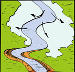
[[File:flooding plain.jpg|200px|thumb|left|Flood plain,Karachi]] | |||
[[File:river of garbage.jpg|200px|thumb|left|River of garbage,Karachi]] | |||
1. Flooding – development of flood risk zones by the rivers of Lyari and Malir, adapt city sewer infrastructure accordingly to the rainfall intensity and maintain it regularly, prevent settlements in areas that are in flood risk zones, increase areas covered with vegetation. | 1. Flooding – development of flood risk zones by the rivers of Lyari and Malir, adapt city sewer infrastructure accordingly to the rainfall intensity and maintain it regularly, prevent settlements in areas that are in flood risk zones, increase areas covered with vegetation. | ||
| Line 167: | Line 166: | ||
=== Proposals for Climate Change Mitigation === | === Proposals for Climate Change Mitigation === | ||
Climate change mitigation refers to decreasing of greenhouse gas concentrations in order to reduce the effects of global warming through various methods such as the use of alternative energy sources, energy efficiency and conservation, carbon sinks, geoengineering and many more. | Climate change mitigation refers to decreasing of greenhouse gas concentrations in order to reduce the effects of global warming through various methods such as the use of alternative energy sources, energy efficiency and conservation, carbon sinks, geoengineering and many more. | ||
In this case, Karachi city could reduce carbon dioxide emisson by discouraging the use of private vehicles, for example by implementing higher taxes for cars that run on fossile fuels, raise fuel cost and encourage use of hybrid cars by lowering taxes on them. Or by implementing steam and odd policy, depending on the day of the month and car licence plate number, inhabitants can or cannot use their private cars. Also, lowering the cost of public transportation and organising a public traffic transport network that can satisfy the city's needs would encourage people to use public transport more often. | In this case, Karachi city could reduce carbon dioxide emisson by discouraging the use of private vehicles, for example by implementing higher taxes for cars that run on fossile fuels, raise fuel cost and encourage use of hybrid cars by lowering taxes on them. Or by implementing steam and odd policy, depending on the day of the month and car licence plate number, inhabitants can or cannot use their private cars. Also, lowering the cost of public transportation and organising a public traffic transport network that can satisfy the city's needs would encourage people to use public transport more often. | ||
[[File:Yangtzebasin.png|250px|thumb|left|Location of the central floodplains wetlands downstream of Three Gorges Dam on the Yangtze River, China]] | |||
Implementing a green infrastructure network through the city would help by accumulating carbon dioxide into plants and it would serve as a carbon sink. One of the ways to make use of constant floods would be, instead of raising barriers to prevent rivers from flooding, to allow them to flood their basins that would serve as wetlands for carbon dioxide accumulation. Wetlands could also serve as natural reserves for wildlife, water recycling and desalinization and absorb some of the city's heat problems along with implementation of green roofs. | |||
'''Example:''' After nearly a millennium of efforts to control floods in the Yangtze River basin with dikes, polders and other hard engineering measures, the Chinese government adopted a radically different approach after the disastrous 1998 floods. A soft path approach was used that saw several thousand square kilometers of floodplains restored to safely hold and slowly release peak floodwaters. | |||
Restoring the floodplains was a ‘no regrets’ adaptation that is robust in managing climatic variability and change, and has extensive environmental and socio-economic co-benefits. In this case larger floods can be more safely managed. The environment has benefitted through improved water quality, recovery of flora and fauna, conservation of threatened species and designation of nature reserves. While 2.4 million people were relocated from the most flood-prone lands to adjacent, higher ground, in general their livelihoods and resilience have improved. Full case study can be read at [http://www.worldresourcesreport.org/files/wrr/wrr_case_study_controlling_yangtze_river_floods.pdf Controlling Yangtze River Floods: A New Approach] | |||
<gallery caption=" " widths="1050px" heights="300px" perrow="6"> | |||
Image:Street profile.jpg|Street profile - green roofs. Sketch by Bojan Ilijin. | |||
</gallery> | |||
=== Your scenario === | === Your scenario === | ||
The 4th Assessment Report of Inter – Governmental Panel on Climate Change (IPCC) published in 2007 indicates that global temperature rises of 2 – 4.5°C are almost inevitable due to increased concentration of green house gases a byproducst of human activities. Global warming will have serious consequences for agriculture, biodiversity and sea level rise. If temperatures keep rising gradually, people will adapt over time to higher temperatures if right measures, like green infrastructure, water harvesting and cycling, to mitigate some of the heath, are implemented. Otherwise due to increased needs for water mortality rate will grow, and especially elderly, children and poor will suffer the most. | |||
<gallery caption=" " widths="1050px" heights="300px" perrow="6"> | |||
Image:Flood plain cross section.jpg|Flood plain cross section. Sketch by Bojan Ilijin. | |||
</gallery> | |||
There will be no exceptions for the coastal cities when it comes to sea level rise due to climate change. It is well known that a large part of the world's population has always lived in coastal areas, beacause of fertile soil and fishing waters. When sea levels reach critical levels for people to move further inland it will be to late without adequate plans where to move. People will start moving as far away from the new threat as possible, settle at new locations where they'll face possible new problems, lack of food and drinking water which will result in illnesses, crime and increased mortality. To avoid the worst case scenario proper measures must be taken and carefully planned where and how to dislocate people from risk zones, and provide them with everything needed for normal life. Possible scenario how sea level rise will affect coast of Pakistan and India can be found here [http://flood.firetree.net/?ll=16.3412,97.3388&z=12 Asia - posssible sea level rise scenarios] | |||
[[File:flood plain2.jpg|200px|thumb|left|Flood plain. Sketch by Bojan Ilijin]] | |||
=== What can be generalized from this case study? === | === What can be generalized from this case study? === | ||
Karachi is one of the most important cites for Pakistan because of it's big potential, but unfortunately it is also under environmental threats due to unsustainable land use, missing spatial and landscape planning studies and uncontrolled immigration. | |||
Furthermore, there is exceeding bearing capacity in the city that plays a major role about the disaster threats such as storms, floods and sea level rise. There is a need to take the ''climate change'' issue into account in landscape planning studies for Karachi for the purpose of better landscape management and protection which can help to ease the effects of climatic changes on natural vegetation, human life and natural resources. | |||
<gallery caption=" " widths="500" heights="300px" perrow="6"> | |||
Image:Concept map Group Q.jpeg|Concept map the case study Karachi | |||
</gallery> | |||
There are some research questions generated from this study: | |||
* Which kind of developments accelerate the climatic changes in the urbanized areas? | |||
* How can landscape planning and design studies help to ease the effects of climate change? | |||
* Are stakeholders in Karachi aware of the negative impacts of uncontrolled urbanization on natural landscape? | |||
* Does public participation play a key role for better environment? | |||
* Which disciplines should cooperate to create planning proposals for the climate change problem? | |||
* How does the economic situation of Karachi effect landscape protection studies? | |||
* Do local people take care of their environment as they are facing economical problems? | |||
<gallery caption=" " widths="1050px" heights="300px" perrow="6"> | |||
Image:Green buildings.jpg|Green buildings. Sketch by Bojan Ilijin. | |||
</gallery> | |||
=== Presentation Slides === | |||
<gallery caption=" " widths="200px" heights="150px" perrow="5"> | |||
Image:slide one.jpg|slide one | |||
Image:slide two.jpg|slide two | |||
Image:slide three.jpg|slide three | |||
</gallery> | |||
=== Image Gallery === | === Image Gallery === | ||
| Line 201: | Line 243: | ||
Image:Tropical cyclone 03B.jpg|Tropical Cyclone Gonu, Cyclone 03B, in June 2007 caused flooding and wind damage in Karachi | Image:Tropical cyclone 03B.jpg|Tropical Cyclone Gonu, Cyclone 03B, in June 2007 caused flooding and wind damage in Karachi | ||
Image:Flood.jpg|Pakistanis wade through a flooded road caused by heavy monsoon rainfall in Karachi | Image:Flood.jpg|Pakistanis wade through a flooded road caused by heavy monsoon rainfall in Karachi | ||
Image:Karachi flooding.jpg|Flooded house [http://www.flickr.com/photos/fiverupees/1130383537/] | |||
Image:Poorness.jpg|Poorness [http://www.flickr.com/photos/balazsgardi/6476466543/] | |||
Image:Flooding plain.jpg|Flood plain [http://www.flickr.com/photos/medico_international/4932122416/] | |||
Image:River of garbage.jpg|River of garbage [http://www.flickr.com/photos/zainub/430144884/] | |||
Image:Flood plain cross section.jpg|Flood plain cross section | |||
Image:Flood plain2.jpg|Flood plain sketch | |||
Image:think of the air before you can see it.jpg|Sketch - Think of the air before you can see it | |||
Image:Green buildings.jpg|Sketch - green buildings | |||
Image:Street profile.jpg|Sketch - Street profile | |||
</gallery> | </gallery> | ||
=== References === | === References === | ||
<references/> | |||
2. Farhan Anwar (2012). ''Karachi City Climate Change Adaptation Strategy, Pakistan'' [http://www.scribd.com/doc/100286295/Karachi-City-Climate-Change-Adaptation-Stratergy-A-road-Map] | 2. Farhan Anwar (2012). ''Karachi City Climate Change Adaptation Strategy, Pakistan'' [http://www.scribd.com/doc/100286295/Karachi-City-Climate-Change-Adaptation-Stratergy-A-road-Map] | ||
Latest revision as of 18:57, 30 January 2013
| Place | Karachi | |||||||||||
| Country | Pakistan | |||||||||||
| Topic | Impacts of climate change on Karachi | |||||||||||
| Author(s) | Ana Žmire, Farzan Azarpour, Bojan Ilijin | |||||||||||

| ||||||||||||
| {{#widget:GoogleMaps | width=300 | height=200 | lat=24.534113 | lng=67.032597 | zoom=7 | centermarker=yes | maptypecontrol=yes | overviewmapcontrol=yes | largemapcontrol=yes | scalecontrol=yes
}} | ||
Rationale: Why have you selected this case study area?
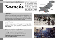
- The area that we have chosen is Karachi, the largest city in Pakistan. Main reasons why we chose this area is that the city of Karachi tops the list of cities unsuitable for life, because terrestrial and aquatic ecosystems are being destroyed, air is polluted and natural resources are misused.
- There is a growing socio-economic inequality and increasing environmental degradation.
- Some of the problems that are present in this area are increased CO2 concentrations, heat waves, cyclones, floods, lack of drinking water and falling of groundwater levels.
Authors' perspectives
As landscape architects we are closely associated with changes in landscape due to climate change. Learning about climate changes in a region that is far from ours will help us understand and prevent damage, slow down rapid change in climate and landscape, not only in our region but also all over the world. Karachi City represent an example how neglecting landscape reflects on climate, and what will happen if people don't start understanding what the consequences of their actions are.
Landscape and/or urban context
Karachi, Pakistan, the country's largest city and the capital of Sind province, lies on the flat, sandy coast facing the Arabian Sea just north of the Indus River delta. It became capital city of a new Dominion of Pakistan in 1947, until 1960 when Islamabad was constructed and became tne new capital city of Pakistan.
Karachi is Pakistan's largest industrial and commercial center, handling much of Pakistan's international trade. Leading manufacturing industries include food processing, shipbuilding, and the making of textiles, chemicals, and machinery. Oil refineries, a nuclear power plant, and the nation's first steel mill are nearby. Karachi is Pakistan's only seaport and the center of the nation's fishing industry. It also serves as the main port for landlocked Afghanistan.
Originally a tiny fishing village, Karachi became a trading center in the 1700's. After gaining control of the region in the 19th century, British developed the city into an important port. Rapid growth came after Pakistan became independent in 1947, largely, because of the huge influx of Muslim refugees from India. Karachi was the national capital from 1947 until 1959. Over the next several decades it was one of the fastest growing cities in the world, doubling its population from 1981 to 1999.Geography in Karachi
Population

The urban population has increased from 4,015,000 (14.2 per cent of the total) in 1941 to 42,458,000 (32.5 per cent of total) in 1998. The 1998 figures have been challenged since only those settlements have been considered as urban which have urban local government structures. Population density as a whole has also increased from 42.5 people per km2 in 1951 to 164 in 1998.
The earliest inhabitants of the area that became Karachi were Sindhi tribes. Before the end of British colonial rule and the subsequent independence of Pakistan in 1947, the population of the city was vastly consisting Hindus and Sikhs. The city is still a home to a large community of Gujarati Muslims who were one of the earliest settlers in the city, and still form the majority in Saddar Town. Other early settlers included the Marwari Muslims, Parsis originally from Iran, Marathi and Konkani Muslims from Maharashtra (settled in Kokan Town), Goan Catholics and Anglo-Indians. Most non-Muslims left the city to India in the 1950s, after independence, but there are still small communities of Parsis, Goan Catholics and Anglo-Indians in the city.Demographics of Karachi
Topography
Karachi may be broadly divided into two parts; the hilly areas in the north and west and an undulating plain and coastal area in the south-east. The hills in Karachi are the off-shoots of the Kirthar Range. The highest point of these hills in Karachi is about 528m in the extreme north. All these hills are devoid of vegetation and have wide intervening plains, dry river beds and water channels. Karachi has a long coastline in the south. The famous sea beaches include Hawks Bay,Paradise Point, Sands Pit, and Clifton. China Creek and Korangi Creek provide excellent calm water channels for rowing and other water activities. Away from the shoreline are small islands including Shamsh Pir, Baba Bhit, Bunker, Salehabad and Manora.[1].
According to the find-ings of a study funded by the Asian Development Bank (ADB) – Comprehensive Plan for Forestation, Aesthetc Plantaton and Landscaping for Karachi, 2008 - total vegetation cover in Karachi as estmated through satellite imageries is 62,643 acres which works out as 7% of the total land area of 907,001 acres. Karachi City Climate Change(Adaptation Stratergy): A road Map
Cultural/social/political context
Culture

Krokola was the ancient name of Karachi what literally means „a place where crocodile worship“. Around 1558, Karachi was a conglomerate of fishing villages, called Kalachi or Kalati, and in 1729, Seth Bhoju Mal laid foundation of a small township on the left bank of Lyari River. Town was recognized for commerce in the period of the Kalhora princess in 1793. Until 1839, after the capture of Manora fort that put British in possession of the town. The modern port – city was developed by British in the 19th century. In 1947, after the independence of Pakistan, Karachi was chosen to be its capital, and it was settled by Muslim refugees, which radically expanded city's population and transformed its demographics and economy.
Economy
Karachi is the financial and commercial capital of Pakistan, and a nerve center of Pakistan's economy. In line with its status as a major port and the country's largest metropolis, it accounts for a lion's share of Pakistan's revenue which is around 25%. It also contributes to Pakistan's manufacturing sector with approximately 30 percent. It has large industrial zones which are located on the fringes of the main city, and its primary areas of industry are textiles, pharmaceuticals, steel, and automobiles. The economic stagnation caused by political anarchy, ethnic strife and resultant military operation during late 1980s and 1990s led to an exit of industry from Karachi.
As one of the most rapidly growing cities in the world, Karachi faces challenges that are central to many developing metropolises, including traffic congestion, pollution, poverty and street crime. These problems continue to earn Karachi low rankings in livability comparisons. Economy of Karachi
Legal framework
The politics of Karachi takes place at the municipal, provincial and federal levels of the government. First form of government was established in 1846 in form of a conservancy board to control the spread of cholera in the city, and in 1852 board became a municipal commitee. Administrative districts changed in numbers and size over the years, and since 2011, City District Government of Karachi has been de-merged into five districts: Karachi East, Karachi West, Karachi Central, Karachi South and Malir.Politics of Karachi
Decentralization and absence of a coordination between administrative districts is one of the main problems in Karachi. Due to a variety of reasons, mostly political, the mandated relevance of the local government development authorities has been minimized.
Local Climate
Karachi is located on the coast, and therefore has an arid climate with low average precipitation levels (approx. 250 mm (9.8 in) per annum), the bulk of which occurs during the July–August monsoon season. Winters are mild and dry, while the summers are warm and humid.
The proximity to the sea maintains humidity levels at a near-constant high and cool sea breezes relieve the heat of the summer months. December and January are dry and pleasant as compared to the warm summers that dominate through the late spring (March) to the pre-monsoon season (June). Compared to other parts of Pakistan, Karachi's weather is considered mild.
The city's highest monthly rainfall, 429.3 mm (16.90 in), occurred in July 1967. The city's highest rainfall in 24 hours occurred on 7 August 1953, when about 278.1 millimetres (10.95 in) of rain lashed the city, resulting in major flooding.[30] Karachi's highest recorded temperature is 47 °C (117 °F), which was recorded on 18 June 1979,and the lowest is 0.0 °C (32.0 °F), recorded on 21 January 1934.

The monsoon and the Western Disturbance are the two main factors which alter the weather over Karachi; otherwise, Continental air prevails for rest of the year. Following are the main factors that alter the weather over Karachi city.
Western Disturbances mostly occur during the winter months and cause drizzle to light showers, temperature also decreases due to it. Tropical Storms usually form during the summer months from late April till June and then from late September till November. Southwest Monsoon occurs in summer from the month of July till September. Monsoon rains bring much awaited relief from the scorching summer heat. These monsoon rains are quite heavy by nature and can cause significant flooding. Continental air prevails during the period when there is no precipitation in the metropolis. Climate of Karachi
Analysis of vulnerability
- Karachi's biggest problems in terms of vulnerability due to climate change are: flooding, drought, extreme heat events and sea level rise.

Flooding is main problem that threatens Karachi. Besides tidal flooding which endangers fishing settlements on the coast there are 3 more sources of flooding in Karachi.
1. Fluvial flooding – from Lyari and Malir rivers and their tributaries
2. Surface water flooding – from heavy rainfall that overcomes the drainage system
3. Sewer flooding – from sewer overflowing
that primarily threaten fishing settlements at coast, slums and low lying localities and hill settlements.
Possible impacts of flooding: loss of life and personal injury, direct damage to property, infrastructure , contaminaton and disease from flood and sewer water, possible relocaton and resettlement of communites.

Drought is a consequence of insufficient rainfall in Karachi.
Possible impacts of drought: reduced river flow, reduced recharge of groundwater reserves, increased evapotranspiration, increased demand for water by people and wildlife, impacts on farming
Extreme heat events are defined as extended periods of hotter than average temperatures, and it can cause a problem due to people of different age have different abilities to deal with high temperatures. Constantly growing population density in Karachi, transport and industrial growth which increase fossil fuel consumption and emissions of CO2 all lead to urban heat island effect.
Possible impacts of extreme heat events: urban heat island effect, increased water usage, increased demand in energy for cooling, illnesses that are heat related and death, damage to infrastructure (such as electricity systems).
Sea level rise is closely connected with extreme heat events, that are causing ice melting and rise of the level of the oceans.
Possible impacts of sea level rise: damage to ecosystems, loss of fishing communities at coast, damage to residential, governmental and recreational infrastructure
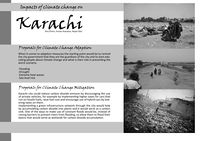
Proposals for Climate Change Adaption

When it comes to adaption measures the starting point would be to remind the city government that they are the guardians of the city and to start educating people about climate change and what is their role in preventing the worst scenario. There are no measures that can prevent climate change, only those that lessen the influence and damage of climate change, so our proposal for adaption would be:


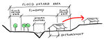
1. Flooding – development of flood risk zones by the rivers of Lyari and Malir, adapt city sewer infrastructure accordingly to the rainfall intensity and maintain it regularly, prevent settlements in areas that are in flood risk zones, increase areas covered with vegetation.
2. Drought – implement measures to promote sustainable water use in farming, prevent unsustainable sand extraction from river basins, implement policies for water harvesting and water recycling.
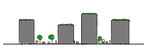
3. Extreme heat waves – increase areas covered with vegetation, implement green roofs, implement policy that will discourage use of private vehicles, implement environment friendly energy sources, use of building materials that reduce overheating.
4. Sea level rise – place flooding barriers along rivers and and in areas in tidal flooding zones, dislocation of people from the risk zones, restrict development in the coastal area, prevention of devastation and reestablishment of mangroves that can act as tidal buffer.
To assure sustainability of listed measures planning should be on all levels, national, regional and local, and functional legal framework would have to be implemented.
Proposals for Climate Change Mitigation
Climate change mitigation refers to decreasing of greenhouse gas concentrations in order to reduce the effects of global warming through various methods such as the use of alternative energy sources, energy efficiency and conservation, carbon sinks, geoengineering and many more.
In this case, Karachi city could reduce carbon dioxide emisson by discouraging the use of private vehicles, for example by implementing higher taxes for cars that run on fossile fuels, raise fuel cost and encourage use of hybrid cars by lowering taxes on them. Or by implementing steam and odd policy, depending on the day of the month and car licence plate number, inhabitants can or cannot use their private cars. Also, lowering the cost of public transportation and organising a public traffic transport network that can satisfy the city's needs would encourage people to use public transport more often.

Implementing a green infrastructure network through the city would help by accumulating carbon dioxide into plants and it would serve as a carbon sink. One of the ways to make use of constant floods would be, instead of raising barriers to prevent rivers from flooding, to allow them to flood their basins that would serve as wetlands for carbon dioxide accumulation. Wetlands could also serve as natural reserves for wildlife, water recycling and desalinization and absorb some of the city's heat problems along with implementation of green roofs.
Example: After nearly a millennium of efforts to control floods in the Yangtze River basin with dikes, polders and other hard engineering measures, the Chinese government adopted a radically different approach after the disastrous 1998 floods. A soft path approach was used that saw several thousand square kilometers of floodplains restored to safely hold and slowly release peak floodwaters. Restoring the floodplains was a ‘no regrets’ adaptation that is robust in managing climatic variability and change, and has extensive environmental and socio-economic co-benefits. In this case larger floods can be more safely managed. The environment has benefitted through improved water quality, recovery of flora and fauna, conservation of threatened species and designation of nature reserves. While 2.4 million people were relocated from the most flood-prone lands to adjacent, higher ground, in general their livelihoods and resilience have improved. Full case study can be read at Controlling Yangtze River Floods: A New Approach
-
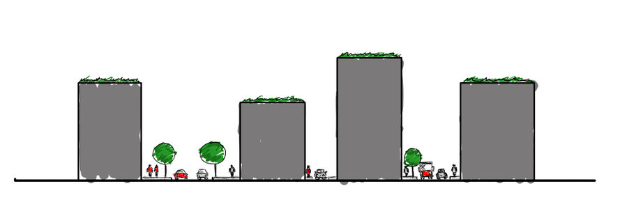 Street profile - green roofs. Sketch by Bojan Ilijin.

Your scenario
The 4th Assessment Report of Inter – Governmental Panel on Climate Change (IPCC) published in 2007 indicates that global temperature rises of 2 – 4.5°C are almost inevitable due to increased concentration of green house gases a byproducst of human activities. Global warming will have serious consequences for agriculture, biodiversity and sea level rise. If temperatures keep rising gradually, people will adapt over time to higher temperatures if right measures, like green infrastructure, water harvesting and cycling, to mitigate some of the heath, are implemented. Otherwise due to increased needs for water mortality rate will grow, and especially elderly, children and poor will suffer the most.
-
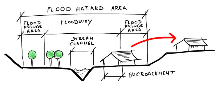 Flood plain cross section. Sketch by Bojan Ilijin.

There will be no exceptions for the coastal cities when it comes to sea level rise due to climate change. It is well known that a large part of the world's population has always lived in coastal areas, beacause of fertile soil and fishing waters. When sea levels reach critical levels for people to move further inland it will be to late without adequate plans where to move. People will start moving as far away from the new threat as possible, settle at new locations where they'll face possible new problems, lack of food and drinking water which will result in illnesses, crime and increased mortality. To avoid the worst case scenario proper measures must be taken and carefully planned where and how to dislocate people from risk zones, and provide them with everything needed for normal life. Possible scenario how sea level rise will affect coast of Pakistan and India can be found here Asia - posssible sea level rise scenarios

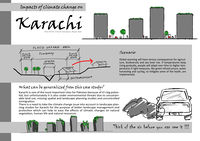
What can be generalized from this case study?
Karachi is one of the most important cites for Pakistan because of it's big potential, but unfortunately it is also under environmental threats due to unsustainable land use, missing spatial and landscape planning studies and uncontrolled immigration. Furthermore, there is exceeding bearing capacity in the city that plays a major role about the disaster threats such as storms, floods and sea level rise. There is a need to take the climate change issue into account in landscape planning studies for Karachi for the purpose of better landscape management and protection which can help to ease the effects of climatic changes on natural vegetation, human life and natural resources.
-
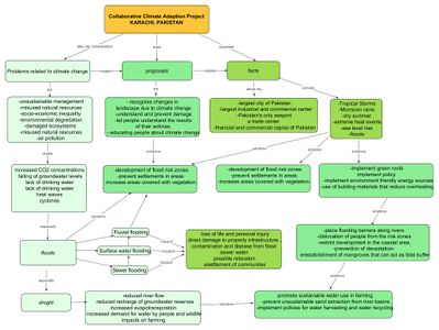 Concept map the case study Karachi

There are some research questions generated from this study:
- Which kind of developments accelerate the climatic changes in the urbanized areas?
- How can landscape planning and design studies help to ease the effects of climate change?
- Are stakeholders in Karachi aware of the negative impacts of uncontrolled urbanization on natural landscape?
- Does public participation play a key role for better environment?
- Which disciplines should cooperate to create planning proposals for the climate change problem?
- How does the economic situation of Karachi effect landscape protection studies?
- Do local people take care of their environment as they are facing economical problems?
-
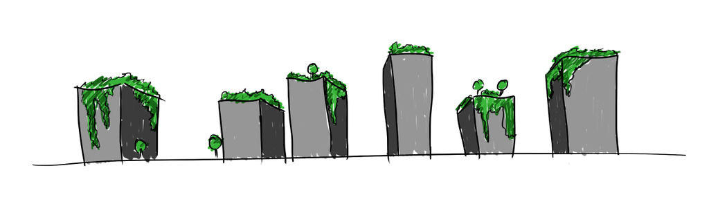 Green buildings. Sketch by Bojan Ilijin.

Presentation Slides
-
 slide one
 -
 slide two
 -
 slide three


Image Gallery
-
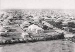
 Aerial of Karachi City
 -
 Karachi in 1889
 -
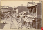 Busy street scene in Karachi, 1890
 -
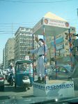 A traffic policeman fights a losing battle in Karachi
 -
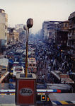 Karachi traffic problem, 1994
 -
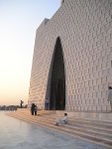 Mozar Quaid-e-Azam, the burial site of Mohammad Ali Jinnah
 -
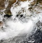 Tropical Cyclone Gonu, Cyclone 03B, in June 2007 caused flooding and wind damage in Karachi
 -
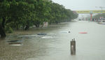 Pakistanis wade through a flooded road caused by heavy monsoon rainfall in Karachi
 -
![Flooded house [1]](/images/thumb/8/82/Karachi_flooding.jpg/100px-Karachi_flooding.jpg) Flooded house [1]
Flooded house [1] -
![Poorness [2]](/images/thumb/5/5d/Poorness.jpg/150px-Poorness.jpg) Poorness [2]
Poorness [2] -
![Flood plain [3]](/images/thumb/5/54/Flooding_plain.jpg/150px-Flooding_plain.jpg) Flood plain [3]
Flood plain [3] -
![River of garbage [4]](/images/thumb/6/6b/River_of_garbage.jpg/150px-River_of_garbage.jpg) River of garbage [4]
River of garbage [4] -
 Flood plain cross section
 -
 Flood plain sketch
 -
 Sketch - Think of the air before you can see it
 -
 Sketch - green buildings
 -
 Sketch - Street profile


![Poorness [2]](/index.php?title=File:Poorness.jpg)

References
- ↑ Arif Hasan and Masooma Mohib (2003). Understanding Slums: Case Studies for the Global Report 2003 case study of Karachi, Pakistan http://www.ucl.ac.uk/dpu-projects/Global_Report/cities/karachi.htm
2. Farhan Anwar (2012). Karachi City Climate Change Adaptation Strategy, Pakistan [5]