Group K - Collaborative Climate Adaption Project: Difference between revisions
| (175 intermediate revisions by 5 users not shown) | |||
| Line 10: | Line 10: | ||
| '''Country''' || style="background:Lavender"|''Egypt'' | | '''Country''' || style="background:Lavender"|''Egypt'' | ||
|- | |- | ||
| '''Topic''' || style="background:Lavender"|'' | | '''Topic''' || style="background:Lavender"|''Effects of climate change on coastal cities'' | ||
|- | |- | ||
| '''Author(s)''' || style="background:Lavender"|Martina Sekutor, Ilze Draudina, Emil Tanner'' | | '''Author(s)''' || style="background:Lavender"|Martina Sekutor, Ilze Draudina, Emil Tanner'' | ||
|- | |- | ||
| colspan="3" align="center" style="background:silver"| [[File: | | colspan="3" align="center" style="background:silver"| [[File:Alexandria_skyline.jpg|300px]] | ||
|- | |- | ||
| ||style="background:Lavender"| | | ||style="background:Lavender"| | ||
| Line 31: | Line 31: | ||
}} | }} | ||
|} | |} | ||
=== Rationale: Why have you selected this case study area? === | === Rationale: Why have you selected this case study area? === | ||
Climate changes are already having an enormous effect on ecosystems, agriculture, forests, hydrological cycle, air quality etc. The Mediterranean region is one of the most threatened on the Earth. Mediterranean climates are found in only five places on the Earth: California and northern Baja California, the basin of the Mediterranean Sea, southwestern Australia, the western cape of South Africa and the central coast of Chile [http://www.medclimatechangeinitiative.org/ (Mediterranean climate change…)]. These regions cover only a small part of the | Climate changes are already having an enormous effect on ecosystems, agriculture, forests, hydrological cycle, air quality etc. The Mediterranean region is one of the most threatened on the Earth. Mediterranean climates are found in only five places on the Earth: California and northern Baja California, the basin of the Mediterranean Sea, southwestern Australia, the western cape of South Africa and the central coast of Chile [http://www.medclimatechangeinitiative.org/ (Mediterranean climate change…)]. These regions cover only a small part of the Earth's land surface (about 2,2 percent), but also incorporate about 20 percent of all known plant species. Only the tropical rainforests of the western hemisphere and Southeast Asia have a bigger density of plant species (Shaw, 2010). By 2100, the Mediterranean biome is presumed to loose proportionally the largest biodiversity of all terrestrial biomes because of it's sensitivity to multiple biodiversity threats(Klausmeyer and Shaw, 2009). | ||
One of the most noticeable coastal | One of the most noticeable coastal cities in the Mediterranean Sea region is Alexandria in Egypt and here it is chosen as the case study area. Alexandria is an important area for industry, agriculture, fisheries and tourism. Because of the lack of environmental monitoring and legal framework, Alexandria is subordinated to serious changes. For all of our group members this area is a new challenge and a great opportunity to study the impact of climate change on the high value coastal areas. | ||
=== Authors' perspectives === | === Authors' perspectives === | ||
One of the requirements of landscape architecture as a profession is to try to always take climate change into consideration. This becomes especially important when dealing with plans for larger scale projects and areas inhabited by people (urban or rural) because it is likely that any action taken or measure implemented will have an impact on a larger number of people. Considering landscape architecture is a multi-disciplinary field we believe landscape architects can offer a unique view on problems caused by climate change and provide solutions that represent an optimal compromise that will benefit an area in it's entirety, and not just some of it's elements. | One of the requirements of landscape architecture as a profession is to try to always take climate change into consideration. This becomes especially important when dealing with plans for larger scale projects and areas inhabited by people (urban or rural) because it is likely that any action taken or measure implemented will have an impact on a larger number of people. Considering landscape architecture is a multi-disciplinary field we believe landscape architects can offer a unique view on problems caused by climate change and provide solutions that represent an optimal compromise that will benefit an area in it's entirety, and not just some of it's elements. | ||
=== Landscape and/or urban context=== | === Landscape and/or urban context=== | ||
Alexandria lies on the Mediterranean coast in the north central part of Egypt. With a population of about 4.1 million, it is the second-largest city in Egypt. With | Alexandria lies on the Mediterranean coast in the north central part of Egypt, at the western edge of the Nile River Delta. With an area of 300 square km and a population of about 4.1 million, it is the second-largest city in Egypt. With it's northerly coastal boundaries stretching nearly 32 km or 20 mi, Alexandria is considered to be the largest coastal city on the Mediterranean Sea. | ||
Being the standpoint to Egypt’s largest seaport and natural gas and oil pipelines from the Suez, the city is of great economic importance. The port handles close to 80% of Egypt’s imports and exports. | Being the standpoint to Egypt’s largest seaport and natural gas and oil pipelines from the Suez, the city is of great economic importance. The port handles close to 80% of Egypt’s imports and exports. | ||
Alexandria is also an attractive tourist destination with its beaches and monuments. | Alexandria is also an attractive tourist destination with its beaches and monuments[http://en.wikipedia.org/wiki/Alexandria]. | ||
Looking at satellite imagery, most of Alexandria is densely built with very few green spaces available. | Looking at satellite imagery, most of Alexandria is densely built with very few green spaces available. Also, land use maps have been generated for the coastal area illustrating the land use activities along the Mediterranean coast[http://www.isprs.org/proceedings/XXXV/congress/comm7/papers/245.pdf]. | ||
[[File:Alexandria Landuse 1990.png]] | |||
The image above shows Land use 1990 | |||
[[File:Alexandria Landuse 2000.png]] | |||
The image above shows Land use 2000 | |||
The pressure of urbanization has seen a great part of Maryout Lake being drained. Most of urban expansion is oriented westward. Agricultural land in the east and the south east has also been lost to urbanization. Apart from the lake and farmland, areas of the desert and coastal plains have as well been developed as new housing locations[http://research.ncl.ac.uk/forum/v5i1/azaz.pdf]. | |||
[[File:Landuse size change.jpg]] | |||
The modern city extends 25 miles (40 km) east to west along a limestone ridge, 1–2 miles (1.6–3.2 km) wide, that separates the salt lake of Maryūṭ, or Mareotis — now partly drained and cultivated — from the Egyptian mainland. The southern parts are characterized by irregular hills with an elevation from 0-40 m above the mean Sea level with a slope towards the sea. | |||
[[File:Egypt_Topography.jpg]] | |||
Topograpy | |||
An hourglass-shaped promontory formed by the silting up of a mole (the Heptastadion), which was built soon after Alexandria’s founding, links the island of Pharos with the city centre on the mainland. It's two steeply curving bays form the basins for the Eastern Harbour and the Western Harbour[http://www.britannica.com/EBchecked/topic/14376/Alexandria/59263/Landscape?anchor=ref286820]. | |||
=== Cultural/social/political context=== | === Cultural/social/political context=== | ||
'''Culture''' | |||
Alexandria was founded by Alexander the Great in 331 BC and was the Egypt’s capital for over 1000 years. Being associated to Alexander and Cleopatra, Alexandria enjoys a special place in the popular imagination. The transmission of Helenic culture to the wider Mediterranean world can be sourced back to this coastal city. From the beginning of the Mohammed Ali era (1805) up to present time, Alexandria has experienced continuous urban growth seeing it's population rise from 370 000 in 1905 living in an area of about 4 km2 to one of approxmately 4.1 million living on about 300 km2. Alexandria's cultural heritage is part of Egypt's culture. | |||
Egyptian culture is based on five thousand years of recorded history[http://www.venividitravel.com/egypt/egyptian-culture.html]. Ancient Egypt is said to be among the earliest civilizations and having maintained a strictly complex and stable culture, it has had a profound influence on later cultures of Europe, the Middle East and Africa. Egypt evolved through Helenic, Christian, Arabic and Islamic Culture. Today this cultural mix exists in interaction with newer elements, including the influence of modern western culture. | |||
With this great mix and relative freedom, Egypt is considered to be the cultural capital of the Arab World. | |||
'''People''' | |||
The greater population of Alexandria today are Arabic-speaking Egyptians. However, untill 1947 Alexandria was home to immigrants from other Mediterranean countries which included Greece, Italy, Syria and France. After the widespread nationalization of industries and services during the Nasser era most of them left. Like most Egyptians, the majority of the population are Sunni Muslims while the minority make up the indigenous church of Egypt, the Coptic Orthodox. | |||
'''Economy''' | |||
Alexandria’s industries and commercial services include manufacturing, shipping, warehousing, banking, food processing, petrochemical and cement production. The city accounts for approximately two-fifths of Egypt’s industrial production. Most industrial development is concentrated in the western part of the city, around the more modern Western Harbour and along its southern flank. | |||
Agriculture is an important economic activity in the hinterland. The Egyptian government has aimed to encourage food production and divert job seekers from overcrowded urban areas offering long-term loans to graduates for various agricultural projects. | |||
'''Legal framework''' | |||
Alexandria was Egypt’s first fully constituted municipality. It was based upon an organisation formed by the foreign export merchants. In 1929 the municipality was dissolved and later reorganized by the Egyptian government. This followed the increased control through the governorate[http://en.wikipedia.org/wiki/Governorates_of_Egypt]. The governorate is appointed by the president and is then assisted by an elected local council. All governorates fall under the ministry of local affairs. | |||
[[File:464px-Governorates of Egypt.svg.png]] | |||
Governorates of Egypt | |||
=== Local Climate === | === Local Climate === | ||
Because of the prevailing north wind blowing across the Mediterranean Sea, the climate in Alexandria is different from the climate further inland. Alexandria is a semi – desert area. Hot dry summers and moderate winters are characteristic for the climate of Alexandria. The summers are relatively temperate, the hottest months are July and August when the average temperature reaches 30 °C (Climate indicators...)[http://www.climate-zone.com/climate/egypt/celsius/alexandria.htm]. Winters are cool and often marked by a series of storms that can bring torrential rain and even hail. The coldest months are January and February, when the average temperature dips till 13 °C and the average minimum temperature is 8°C (Climate indicators...). The average annual temperature is 21, 3°C (Climate and Temperature Alexandria...)[http://www.alexandria.climatemps.com]. | |||
Moving southward from the Delta to the Sudanese border the average annual temperature increases and the temperature variation becomes similar to those of the open deserts (IPCC, 2007)[http://www.ipcc.ch/publications_and_data/publications_ipcc_fourth_assessment_report_synthesis_report.htm]. | |||
[[File:Temperature_Alexandria.jpg]] | |||
Average temperature in Alexandria. Author: Ilze Draudiņa | |||
The average annual precipitation of Alexandria is about 190mm, with most of the precipitation occurring in January and December, while the average precipitation of all Egypt is about 26mm (Climate and Temperature Egypt...). So Alexandria is one of the wettest areas of Egypt. The driest weather is from June to September when the precipitation may come to 0mm. | |||
[[File:Precipitation_Alexandria.jpg]] | |||
Average precipitation in Alexandria. Author: Ilze Draudiņa | |||
Sirocco (khamsin for Egyptian),a hot spring wind that blows across the country, is an important climatic phenomenon in Egypt. The wind forms a small but forceful low pressure area and rages across the northern coast of Africa. The speed of wind may reach140 kilometers per hour. Sirocco wind is mixed with sand and dust from the deserts and it can increase the air temperature suddenly about 20°C within two hours. It appears usually in April and at times in March and May (IPCC, 2007). | |||
In the National Institute of Oceanography and Fisheries (NIOF) in Egypt a research has been conducted on climatic change and sea level variation of Alexandria in the time period from 1974 – 2006. The main conclusions are: (Said, M., Moursy, Z., and Radwan A.,2006)[http://conference2011.wcrp-climate.org/abstracts/C38/Said_C38_TH16A.pdf] | |||
the mean annual air temperature over Alexandria region increased by about 2.24°C and | |||
the annual mean sea level increased by 9.95 cm over the study period giving a sea level rise of 3 mm per year. | |||
In 2010 heavy rains and strong winds affected several parts of the Middle East and caused damage to dozens of buildings in Egypt. High winds and heavy rains caused a partial collapse of some 28 buildings in Alexandria and there were seven victims(Middle East flooded...) [http://poleshift.ning.com/profiles/blogs/middle-east-flooded-and]. | |||
Based on the IPCC fourth assessment report (IPCC, 2007), temperature increase per decade in Alexandria (since 1979 to 2005) is in the range of 0.05 to 0.15 °C and the temperature will continue to rise. The report is not predicting the change of the precipitation in the same period due to insufficient data to produce reliable trends. | |||
A sea level rise is described in the NIOF research: the sea level rise of 15-20cm by 2020 would be of little consequence, augmentations over 30-50cm by 2050 would have more serious effects, and a sea level rise of 100cm by 2100 could flood land within 30km of the coast or more, affecting 12-15% of Alexandria's land (Said, M., Moursy, Z., and Radwan A.,2006). | |||
=== Analysis of vulnerability === | === Analysis of vulnerability === | ||
The IPCC defines vulnerability as the extent to which a natural or social system is susceptible to sustaining damage from climate change, ... the sensitivity of the system to changes in climate and the ability to adapt the system to changes in climate. | |||
Alexandria's biggest cause of vulnerability is it's geographical position. It is situated on the coast and is therefore at sea level which makes it highly sensitive to constantly rising sea levels. In combination with wave energy, rising sea levels erode and destabilize the coast line, enter the mainland and cause flooding. Flooding can have a severe effect on many or even all aspects of a natural or social system. | |||
In an agricultural context, salt water intrusion causes soil salinization and the loss of valuable farmland. Considering most of Alexandria's agricultural areas are below sea level this presents a high risk for the area's food security. | |||
In an economic context, coastal erosion and rising sea levels can lead to the loss of coastal infrastructure and affect Alexandria's ports. They can also lead to the loss of valuable beaches and have a severe negative effect on the area's tourism activities. | |||
The biggest threat however is to the local inhabitants. Because the area is densely populated, a large number of local people are already having to deal with floods caused by winter storms. Severe or permanent floods caused by rising sea levels could force people to move from the area permanently because the buildings and the infrastructure could be left damaged and unusable. Fresh water supplies would also be negatively affected and that would lead to the development of diseases like cholera and malaria. | |||
Rising sea levels are not the only cause of vulnerability for this area. Rising air and surface temperatures cause droughts which negatively affect animal and plant species as well as people. Elderly people are especially sensitive to temperature changes. Heavy rains, hail storms, strong winds and dust storms from the desert cause damage to the buildings and crops and sometimes even lead to the loss of life. | |||
Because aproximately 40 % of Egypt's industry is located in Alexandria, local oil, petrol and gas industries cause industrial pollution, carbon dioxide emissions and marine pollution. This has already led to the loss of sea species due to higher sea water acidity. It has also played a role in lowering the quality of fresh water sources and it could reduce the productivity of coastal fisheries. | |||
On a larger scale, Alexandria is one of the Nile Delta hotspots when it comes to climate change vulnerability and these areas need to be protected in order to preserve the valuable Delta itself. Strategies and measures regarding protection and management, as well as adaptation and mitigation of the negative effects of climate change should be of national importance to Egypt because so is the Nile Delta. Therefore the insufficient legal framework and climate change strategy for implementing these measures are another cause of vulnerability for this area. | |||
=== Proposals for Climate Change Adaption === | === Proposals for Climate Change Adaption === | ||
In the context of climate change adaption referes to reducing the vulnerability of a biological system through certain necessary measures. Coastal erosion is currently the biggest direct threat to the area of Alexandria because it's consequences could and already have a deep negative impact on several different aspects of the case study area. All those aspects - economy, industry, tourism, agriculture, infrastructure, housing, living conditions, health, biodiversity - have a direct impact on the human population and the general standard of living. Some of our adaption proposals are as follows. | |||
'''A. Coastal erosion''' | |||
In the geological and topographical context Alexandria is built on a coastal plain. On this account the coastal area of Alexandria is subjected to erosion. The coastline of Alexandria can be divided into three categories (Executive summary…)[http://arabworld.worldbank.org/content/dam/awi/pdf/Alexandria_Phase1_ExecSum.pdf]: | |||
1) Seriously eroding areas – flat and low-lying coastal areas, for example western back-shore zone of Abu Quir Bay and El Tineh plain,and also delta coastal plain areas affected by subsidence. Also because of ongoing natural coastal processes the beaches of Alexandria, from Mandara to El Silcila are experiencing long term erosion of approximately 20 cm a year. | |||
2) Artificially protected coastal areas. These areas are at risk of structural defects caused by tsunami or storms, for example, Abu Quir seawall along the Nile Delta coast. | |||
3) Remaining areas along the Alexandria coast can be regarded as safe. | |||
Erosion caused by the climate changes endangers the first mentioned category so it is very important to find solutions to reduce this disruptive process. There could be three decent solutions for adaptation: | |||
'''1. Beach Nourishment''' | |||
Beach nourishment is an adaption technology usually used to protect coastal area from erosion, but it also helps to reduce flooding risk. The aim of this technology is to ensure that the nourishment material is compatible with the existing natural beach material (Reeve et al., 2004). The acquisition of the beach nourishment comes from wave energy dissipation – waves loose energy when they swash the beach. Different beach profiles and gradients interact with waves to differing extent (Technologies...) [http://tech-action.org/Guidebooks/TNA_Guidebook_AdaptationCoastalErosionFlooding.pdf]. | |||
There are different methods how nourishment can be deposited, for example by dredge, trucks or conveyor belts. The most popular method is to supply nourishment material by offshore dredging because it allows to move large quantities of nourishment material from an area where it's removal and transport is cautious to the shoreline (Technologies...). | |||
[[File:Group_K_erosion_2.jpg]] | |||
Beach Nourishment principle. Sketch based on Woods Hole Group schema [http://woodsholegroup.wordpress.com/2011/06/07/what-happens-to-a-nourished-beach-in-a-storm/] | |||
Beach nourishment does not stop the erosion process, but the widened and deepened beach will provide a buffer that protects coastal infrastructure and the coast line from erosion and storm damage. | |||
'''2. Artificial Sand Dunes''' | |||
Another technology which is used to reduce coastal erosion and flooding in the coastal lowlands is artificial sand dune construction. It is possible to combine the beach nourishment and the artificial sand dunes construction (see schema above). Dunes and beaches make a united system that reacts on the changes of wind force and direction, sea level changes or wave climate (Technologies...). | |||
The simplest way of artificial dune construction is to use sediment from dredged sources on the beach. It is useful to build artificial sand dunes and beach nourishment at the same time because sand is readily available. | |||
Vegetation planting is used to strengthen artificial dunes. Vegetation promotes the accumulation of sand from windblown sources which causes growth of the dunes. This technology gives stable protection against coastal flooding and erosion (Technologies...). Artificial sand dunes also provide a valuable coastal habitat for many breeds of plants and animals. | |||
'''3. Seawalls''' | |||
Seawalls function as a barrier for further erosion of the shoreline and also as a protection against flooding. Seawalls are built with the aim to hold or prevent sliding of the soil, and to protect the coastal area of the wave action. There are various materials that can be used for seawall building, for example steel plates, monolithic concrete barriers, brick or block walls and gabions (Kamphuis, 2000). The shape of the seaward face is important in the rejection of wave energy - smooth surfaces | |||
reflect wave energy while irregular surfaces scatter the direction of wave reflection (Technologies...). | |||
[[File:Group_K_seawalls.jpg]] | |||
Principles of the seawalls. Author: Ilze Draudiņa | |||
Seawalls are often used in urban areas because they have lower space requirements than other solutions for coast protection. Seawalls may also fill the function of promenades etc. One other advantage of seawalls is that these constructions are potentially long–lived structures. | |||
'''Monitoring''' | |||
Beach nourishment and artificial sand dunes are not permanent solutions for diminishing coastal erosion. To make these solutions sustainable there must be a monitoring system that controls whether adaptation has achieved it's goals and also assesses when new actions are necessary. All the solutions require regular maintenance and investments. | |||
'''B. Local population''' | |||
Helping the local inhabitants become more resilient to the negative effects of climate change should include improving the infrastructure system and housing/construction quality (to reduce floods, prevent building damage and the development of diseases) and directing further growth away from the more vulnerable areas (by raising tax on building in endangered areas and lowering tax on building in safer zones). However, people relocation can be extremely problematic so it should be carefully planned and result in the development of self sufficient satellite cities with a well integrated transportation system. | |||
'''C. Land use''' | |||
Because salt water intrusion causes soil salinization, activities sensitive to it should be moved further inland. Where that is not an option, a switch to less vulnerable activities should be considered (for example aquaculture and fisheries). Agricultural diversification along with safety measures (for example water harvesting during wet periods, purification and storage for use during droughts) should also be implemented with the final goal of sustainability in mind. | |||
'''Implementation''' | |||
Successful implementation of described measures for both helping the local inhabitants and improving land use requires effective legal regulation. Relevant existing institutions need to set the rules and prohibitions for further development and recovery of already affected areas. Possible scenarios of the effects of climate change need to be constantly assessed, new neccessary institutions established (for example ICZM – Integrated Coastal zone Management) and strategies and detailed plans made on all levels (national, regional and local). | |||
=== Proposals for Climate Change Mitigation === | === Proposals for Climate Change Mitigation === | ||
In the context of climate change, mitigation referes to reducing greenhouse gas emissions (through for example wind energy) or their removal from the atmosphere through carbon sinks (for example urban green systems). | |||
'''1. Renewable energy – wind power''' | |||
Emissions of carbon dioxide (CO2) and greenhouse gases (GHG) heavily influence climate changes. It is possible to lessen the impact of these gases by reducing fossil fuel consumption. In early 1980s a renewable energy strategy was defined as an integral part of the national energy planning in Egypt (Strategy…)[http://www.nrea.gov.eg/english1.html]. Many processes of climate change adaptation or mitigation are linked to bigger consumption of electric energy, for example electromobiles. Etiologically it is important to find possibilities to produce electric energy using renewable resources. Currently the strategic target is to satisfy 20% of the electric energy demand from renewable energy resources by the year 2020, including about 12% from wind power and 8% from other renewable energy resources, for example hydro power, solar energy, etc (Strategy…). This aim may be referred also to Alexandria. The wind power is considered to be the major resource of renewable energy in the national energy planning in Egypt. There are more advantages than disadvantages in use of wind energy (Advantages…)[http://www.technologystudent.com/energy1/wind8.htm]: | |||
'''Advantages of wind power :''' | |||
• Wind energy is a perpetual resource and with modern technology it can be captured efficiently. | |||
• Wind turbines do not cause greenhouse gases or other pollutants after they are built. | |||
• Wind turbines require only a small plot of land. | |||
• Well planned wind farms may become an interesting feature of the landscape. | |||
• Wind energy may be produced for both personal use in farms or for industrial service. | |||
• Wind turbines are comparatively accessible. | |||
'''Disadvantages of wind power:''' | |||
• Wind turbines do not produce a constant amount of electricity, but depend on the strength of the wind. | |||
• Large wind farms are needed to produce enough energy for entire communities. | |||
'''Conclusions''': wind energy is a great renewable resource but it must be combined with other energy sources to provide a stable supply of energy. To ensure that wind farms don’t have a negative influence on the landscape, guidelines of wind farm planning must be developed. | |||
'''2. Urban green systems''' | |||
Green systems need to become an integral part of urban planning, spatial planning and land use planning in general. Surfaces covered with vegetation can serve as carbon sinks and remove CO2 from the atmosphere thus increasing air quality as well as urban living conditions. Open green areas in Alexandria are scarce, however their quantity could increase through designating more surfaces to be turned into parks instead of construction sites and through building green roofs where possible using plants that can endure the local climate. If planned well, these surfaces could be integrated into a valuable green system - green belt, greenway or green wedge. | |||
=== Your scenario === | === Your scenario === | ||
For most coastal regions the rising sea level due to climate change is a great challenge. The city of Alexandria is no exception. According to the IPCC third assessment report (IPCC, 2001), the sea level rise is projected to be between 15-95 cm by the year 2100 for African coastal areas. | |||
Frihy (2003) points out that climate change is not the sole reason for sea level rise, it is also caused by local tectonic activities (subsidence/emergence) and seasonal oceanographic and meteorological processes. The combined sea level rise for Alexandria is expected to be around 7.5mm (1-5 mm due to subsidence and 1.60 mm due to sea level rise) per year. | |||
If no counter measure is taken, a scenario involving a sea level rise between 0.5 m and 1.0 m over | |||
the next century is expected. With such a rise, an area of about 30% of the city will be lost due to inundation leading to environmental refugees. A 0.25 m rise in sea level would put 60% of Alexandria’s population of 4 million below sea level, as well as 56.1% of Alexandria’s industrial sector and a scenario with an expected rise of 0.5 m would see about 67% of the population, 65.9% of the industrial sector, and 75.9% of the service sector under water (see table below). | |||
[[File:Sea level rise 1.JPG]] | |||
The optimistic scenario for Alexandria is one in which the use of renewable energy like wind energy become the trend of the day also refered to as the B1 (see diagram below). | |||
[[File:Egy-LL-5-5.png]] | |||
Another scenario is one in which the trends of today continue and no kind of mitigation is undertaken to contain or reduce greenhouse gases. Coastal areas vulnerable to sea level rise should engage in constructing necessary protection barriers to this effect. The sea level rise and it's impact untill 2050 without any counter action is illustrated in the maps below. | |||
[[File:Sea level rise 2.png|400x600px]] | |||
=== What can be generalized from this case study? === | === What can be generalized from this case study? === | ||
The majority of coastal areas are subjected to devastation caused by the sea level rise, harsh coastal storms and strong winds. On this account coastal areas will be under rising threat of erosion and flooding and the potential for serious property damage along the coastline will increase dramatically. One more global problem is the inundation of coastal wetlands and marshes. It is critical because these territories serve important environmental functions, for example groundwater filtering, settling ground for migrating birds and also serve as foraging areas for many aquatic and terrestrial species, etc. | |||
The climate changes generate a number of research questions: | |||
• Is it possible to lessen the impact of climate changes that are already conspicuous? | |||
• The struggle against climate changes may meet with an obstacle - the lack of resources and finances. | |||
The significance of climate change adaptation and mitigation will grow in many countries. International climate change adaptation and mitigation programs must be implemented and accepted by the countries with the biggest impact on climate changes. | |||
=== Presentation Slides === | |||
<gallery caption=" " widths="150px" heights="150px" perrow="3"> | |||
Image:1. Case study area - Vulnerability.JPG|Slide One | |||
Image:2._Adaption_-_Mitigation.JPG|Slide Two | |||
Image:3._Scenarios.JPG|Slide Three | |||
</gallery> | |||
=== Image Gallery === | === Image Gallery === | ||
<gallery caption=" " widths="150px" heights="150px" perrow="5"> | <gallery caption=" " widths="150px" heights="150px" perrow="5"> | ||
Image: | Image:Beach_-_buildings.jpg|New buildings on Alexandria beaches | ||
Image: | Image:Beach.jpg|Alexandria beach buildings close up | ||
Image: | Image:Concrete blocks.jpg|Concrete blocks used to fight coastal erosion | ||
Image: | Image:Street.jpg|One of Alexandria's main streets | ||
Image: | Image:City square.jpg|A city square in Alexandria | ||
Image: | Image:Alexandria harbour.jpg|Alexandria harbour | ||
Image: | Image:Alexandria library.jpg|Aerial view of Alexandria | ||
Image: | Image:Alexandria beach in 1942.jpg|Alexandria beach in 1942 | ||
</gallery> | </gallery> | ||
=== References === | === References === | ||
Please add literature, documentations and weblinks | Please add literature, documentations and weblinks | ||
Advantages and Disadvantages of Wind Power. Retrieved January 5, 2013 from the Technology Student Website at:http://www.technologystudent.com/energy1/wind8.htm | |||
Climate indicators in Alexandria. Retrieved December 15, 2012 from the Climate zone Website at: http://www.climate-zone.com/climate/egypt/celsius/alexandria.htm | |||
Climate and temperature Alexandria.Retrieved December 15, 2012 from the Climatemps Website at: http://www.alexandria.climatemps.com/ | |||
Climate and temperature Egypt.15, 2012 from the Climatemps Website at:http://www.egypt.climatemps.com/ | |||
Executive summary Phase 1 Report Alexandria. Retrieved January 3, 2013 from the World bank Website at: http://arabworld.worldbank.org/content/dam/awi/pdf/Alexandria_Phase1_ExecSum.pdf | |||
IPCC (2007). Working Group I: The | |||
Physical Science Basis, Technical Summary: The Fourth Assessment Report of the | |||
Intergovernmental Panel on Climate Change. Retrieved December 15, 2012 from the IPCC Website at: http://www.ipcc.ch/publications_and_data/publications_ipcc_fourth_assessment_report_synthesis_report.htm | |||
Kamphuis, J.W.(2000)Introduction to Coastal Engineering and Management. Singapore: World Scientific Publishing. | |||
Klausmeyer, K., and Shaw, R. (2009). Climate change, habitat loss, protected areas and the climate adaptation potential of species in mediterranean ecosystems worldwide. Retrieved December 11, 2012 from PLoS ONE Website at:http://www.plosone.org/article/info:doi/10.1371/journal.pone.0006392 | |||
The Mediterranean climate change. Retrieved December 10, 2012 from the Mediterranean climate change Website at: http://www.medclimatechangeinitiative.org/ | The Mediterranean climate change. Retrieved December 10, 2012 from the Mediterranean climate change Website at: http://www.medclimatechangeinitiative.org/ | ||
Middle East flooded and Alexandria buildings collapsed by the storms in Egypt. Retrieved December 15, 2012 from the Earthe Changes and the Pole Shift Website at: http://poleshift.ning.com/profiles/blogs/middle-east-flooded-and | |||
Reeve, D., Chadwick, A. and Fleming, C.(2004)Coastal Engineering: Processes, Theory and Design Practice. Abingdon: Spon Press. | |||
Said, M., Moursy, Z., and Radwan A. (2006). Climatic change and sea level variations off Alexandria, Egypt. Retrieved December 14, 2012 from the WCRP website at:http://conference2011.wcrp-climate.org/abstracts/C38/Said_C38_TH16A.pdf | |||
Shaw, R. (2010). The nature conservancy in california - Mediterranean q&a with rebecca shaw. Retrieved December 11, 2012 from The Nature Conservancy Website at: http://www.nature.org/ourinitiatives/regions/northamerica/unitedstates/california/explore/mediterranean-qa-with-rebecca-shaw.xml | Shaw, R. (2010). The nature conservancy in california - Mediterranean q&a with rebecca shaw. Retrieved December 11, 2012 from The Nature Conservancy Website at: http://www.nature.org/ourinitiatives/regions/northamerica/unitedstates/california/explore/mediterranean-qa-with-rebecca-shaw.xml | ||
Strategy & Mandate. Retrieved January 5, 2013 from New & Renewable Energy Authority Website at: http://www.nrea.gov.eg/english1.html | |||
Technologies for Climate Change Adaptation: Coastal erosion and flooding. Retrieved January 4, 2013 from Tech Action Website at: http://tech-action.org/Guidebooks/TNA_Guidebook_AdaptationCoastalErosionFlooding.pdf | |||
Climate Change in Egypt: Rising Sea Level, Dwindling Water Supplies, by David Sterman, July 2009. Retrieved January 13, 2013 from: http://www.climate.org/topics/international-action/egypt.html#ii | |||
Development and climate change in Egypt: Focus on coastal resources and the Nile, Shardul Agrawala, Annett Moehner, Mohamed El Raey, | |||
Declan Conway, Maarten van Aalst, Marca Hagenstad and Joel Smith, 2004. Retrieved January 13, 2013 from: http://www.oecd.org/environment/climatechange/33330510.pdf | |||
2.0 Climate change: Alexandria – Egypt. Retrieved January 12, 2013 from: http://switchurbanwater.lboro.ac.uk/outputs/pdfs/CALE_BRN_Climate_cahange_and_water_management_Alexandria.pdf | |||
Sea Level Rise Impacts on the Egyptian Coastal Zone. Retrieved January 12, 2013 from: http://mdgf.referata.com/wiki/Sea_Level_Rise_Impacts_on_the_Egyptian_Coastal_Zone | |||
---- | ---- | ||
[[Category:Climate Change Case Study]] | [[Category:Climate Change Case Study]] | ||
About categories: You can add more categories with this tag: "[[Category:Category Name]]", add your categories | About categories: You can add more categories with this tag: "[[Category:Category Name]]", add your categories | ||
Latest revision as of 14:08, 5 February 2013
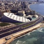
| Area | The Mediterranean Sea Region | |||||||||||
| Place | Alexandria | |||||||||||
| Country | Egypt | |||||||||||
| Topic | Effects of climate change on coastal cities | |||||||||||
| Author(s) | Martina Sekutor, Ilze Draudina, Emil Tanner | |||||||||||

| ||||||||||||
| {{#widget:GoogleMaps | width=300 | height=200 | lat=31.213389 | lng=29.920475 | zoom=10 | centermarker=yes | maptypecontrol=yes | overviewmapcontrol=yes | largemapcontrol=yes | scalecontrol=yes
}} | ||
Rationale: Why have you selected this case study area?
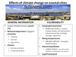
Climate changes are already having an enormous effect on ecosystems, agriculture, forests, hydrological cycle, air quality etc. The Mediterranean region is one of the most threatened on the Earth. Mediterranean climates are found in only five places on the Earth: California and northern Baja California, the basin of the Mediterranean Sea, southwestern Australia, the western cape of South Africa and the central coast of Chile (Mediterranean climate change…). These regions cover only a small part of the Earth's land surface (about 2,2 percent), but also incorporate about 20 percent of all known plant species. Only the tropical rainforests of the western hemisphere and Southeast Asia have a bigger density of plant species (Shaw, 2010). By 2100, the Mediterranean biome is presumed to loose proportionally the largest biodiversity of all terrestrial biomes because of it's sensitivity to multiple biodiversity threats(Klausmeyer and Shaw, 2009). One of the most noticeable coastal cities in the Mediterranean Sea region is Alexandria in Egypt and here it is chosen as the case study area. Alexandria is an important area for industry, agriculture, fisheries and tourism. Because of the lack of environmental monitoring and legal framework, Alexandria is subordinated to serious changes. For all of our group members this area is a new challenge and a great opportunity to study the impact of climate change on the high value coastal areas.
Authors' perspectives
One of the requirements of landscape architecture as a profession is to try to always take climate change into consideration. This becomes especially important when dealing with plans for larger scale projects and areas inhabited by people (urban or rural) because it is likely that any action taken or measure implemented will have an impact on a larger number of people. Considering landscape architecture is a multi-disciplinary field we believe landscape architects can offer a unique view on problems caused by climate change and provide solutions that represent an optimal compromise that will benefit an area in it's entirety, and not just some of it's elements.
Landscape and/or urban context
Alexandria lies on the Mediterranean coast in the north central part of Egypt, at the western edge of the Nile River Delta. With an area of 300 square km and a population of about 4.1 million, it is the second-largest city in Egypt. With it's northerly coastal boundaries stretching nearly 32 km or 20 mi, Alexandria is considered to be the largest coastal city on the Mediterranean Sea. Being the standpoint to Egypt’s largest seaport and natural gas and oil pipelines from the Suez, the city is of great economic importance. The port handles close to 80% of Egypt’s imports and exports. Alexandria is also an attractive tourist destination with its beaches and monuments[1]. Looking at satellite imagery, most of Alexandria is densely built with very few green spaces available. Also, land use maps have been generated for the coastal area illustrating the land use activities along the Mediterranean coast[2].

The image above shows Land use 1990

The image above shows Land use 2000
The pressure of urbanization has seen a great part of Maryout Lake being drained. Most of urban expansion is oriented westward. Agricultural land in the east and the south east has also been lost to urbanization. Apart from the lake and farmland, areas of the desert and coastal plains have as well been developed as new housing locations[3].

The modern city extends 25 miles (40 km) east to west along a limestone ridge, 1–2 miles (1.6–3.2 km) wide, that separates the salt lake of Maryūṭ, or Mareotis — now partly drained and cultivated — from the Egyptian mainland. The southern parts are characterized by irregular hills with an elevation from 0-40 m above the mean Sea level with a slope towards the sea.

Topograpy
An hourglass-shaped promontory formed by the silting up of a mole (the Heptastadion), which was built soon after Alexandria’s founding, links the island of Pharos with the city centre on the mainland. It's two steeply curving bays form the basins for the Eastern Harbour and the Western Harbour[4].
Cultural/social/political context
Culture
Alexandria was founded by Alexander the Great in 331 BC and was the Egypt’s capital for over 1000 years. Being associated to Alexander and Cleopatra, Alexandria enjoys a special place in the popular imagination. The transmission of Helenic culture to the wider Mediterranean world can be sourced back to this coastal city. From the beginning of the Mohammed Ali era (1805) up to present time, Alexandria has experienced continuous urban growth seeing it's population rise from 370 000 in 1905 living in an area of about 4 km2 to one of approxmately 4.1 million living on about 300 km2. Alexandria's cultural heritage is part of Egypt's culture.
Egyptian culture is based on five thousand years of recorded history[5]. Ancient Egypt is said to be among the earliest civilizations and having maintained a strictly complex and stable culture, it has had a profound influence on later cultures of Europe, the Middle East and Africa. Egypt evolved through Helenic, Christian, Arabic and Islamic Culture. Today this cultural mix exists in interaction with newer elements, including the influence of modern western culture. With this great mix and relative freedom, Egypt is considered to be the cultural capital of the Arab World.
People
The greater population of Alexandria today are Arabic-speaking Egyptians. However, untill 1947 Alexandria was home to immigrants from other Mediterranean countries which included Greece, Italy, Syria and France. After the widespread nationalization of industries and services during the Nasser era most of them left. Like most Egyptians, the majority of the population are Sunni Muslims while the minority make up the indigenous church of Egypt, the Coptic Orthodox.
Economy
Alexandria’s industries and commercial services include manufacturing, shipping, warehousing, banking, food processing, petrochemical and cement production. The city accounts for approximately two-fifths of Egypt’s industrial production. Most industrial development is concentrated in the western part of the city, around the more modern Western Harbour and along its southern flank. Agriculture is an important economic activity in the hinterland. The Egyptian government has aimed to encourage food production and divert job seekers from overcrowded urban areas offering long-term loans to graduates for various agricultural projects.
Legal framework
Alexandria was Egypt’s first fully constituted municipality. It was based upon an organisation formed by the foreign export merchants. In 1929 the municipality was dissolved and later reorganized by the Egyptian government. This followed the increased control through the governorate[6]. The governorate is appointed by the president and is then assisted by an elected local council. All governorates fall under the ministry of local affairs.

Governorates of Egypt
Local Climate
Because of the prevailing north wind blowing across the Mediterranean Sea, the climate in Alexandria is different from the climate further inland. Alexandria is a semi – desert area. Hot dry summers and moderate winters are characteristic for the climate of Alexandria. The summers are relatively temperate, the hottest months are July and August when the average temperature reaches 30 °C (Climate indicators...)[7]. Winters are cool and often marked by a series of storms that can bring torrential rain and even hail. The coldest months are January and February, when the average temperature dips till 13 °C and the average minimum temperature is 8°C (Climate indicators...). The average annual temperature is 21, 3°C (Climate and Temperature Alexandria...)[8]. Moving southward from the Delta to the Sudanese border the average annual temperature increases and the temperature variation becomes similar to those of the open deserts (IPCC, 2007)[9].

Average temperature in Alexandria. Author: Ilze Draudiņa
The average annual precipitation of Alexandria is about 190mm, with most of the precipitation occurring in January and December, while the average precipitation of all Egypt is about 26mm (Climate and Temperature Egypt...). So Alexandria is one of the wettest areas of Egypt. The driest weather is from June to September when the precipitation may come to 0mm.

Average precipitation in Alexandria. Author: Ilze Draudiņa
Sirocco (khamsin for Egyptian),a hot spring wind that blows across the country, is an important climatic phenomenon in Egypt. The wind forms a small but forceful low pressure area and rages across the northern coast of Africa. The speed of wind may reach140 kilometers per hour. Sirocco wind is mixed with sand and dust from the deserts and it can increase the air temperature suddenly about 20°C within two hours. It appears usually in April and at times in March and May (IPCC, 2007). In the National Institute of Oceanography and Fisheries (NIOF) in Egypt a research has been conducted on climatic change and sea level variation of Alexandria in the time period from 1974 – 2006. The main conclusions are: (Said, M., Moursy, Z., and Radwan A.,2006)[10] the mean annual air temperature over Alexandria region increased by about 2.24°C and the annual mean sea level increased by 9.95 cm over the study period giving a sea level rise of 3 mm per year.
In 2010 heavy rains and strong winds affected several parts of the Middle East and caused damage to dozens of buildings in Egypt. High winds and heavy rains caused a partial collapse of some 28 buildings in Alexandria and there were seven victims(Middle East flooded...) [11].
Based on the IPCC fourth assessment report (IPCC, 2007), temperature increase per decade in Alexandria (since 1979 to 2005) is in the range of 0.05 to 0.15 °C and the temperature will continue to rise. The report is not predicting the change of the precipitation in the same period due to insufficient data to produce reliable trends. A sea level rise is described in the NIOF research: the sea level rise of 15-20cm by 2020 would be of little consequence, augmentations over 30-50cm by 2050 would have more serious effects, and a sea level rise of 100cm by 2100 could flood land within 30km of the coast or more, affecting 12-15% of Alexandria's land (Said, M., Moursy, Z., and Radwan A.,2006).
Analysis of vulnerability
The IPCC defines vulnerability as the extent to which a natural or social system is susceptible to sustaining damage from climate change, ... the sensitivity of the system to changes in climate and the ability to adapt the system to changes in climate.
Alexandria's biggest cause of vulnerability is it's geographical position. It is situated on the coast and is therefore at sea level which makes it highly sensitive to constantly rising sea levels. In combination with wave energy, rising sea levels erode and destabilize the coast line, enter the mainland and cause flooding. Flooding can have a severe effect on many or even all aspects of a natural or social system.
In an agricultural context, salt water intrusion causes soil salinization and the loss of valuable farmland. Considering most of Alexandria's agricultural areas are below sea level this presents a high risk for the area's food security.
In an economic context, coastal erosion and rising sea levels can lead to the loss of coastal infrastructure and affect Alexandria's ports. They can also lead to the loss of valuable beaches and have a severe negative effect on the area's tourism activities.
The biggest threat however is to the local inhabitants. Because the area is densely populated, a large number of local people are already having to deal with floods caused by winter storms. Severe or permanent floods caused by rising sea levels could force people to move from the area permanently because the buildings and the infrastructure could be left damaged and unusable. Fresh water supplies would also be negatively affected and that would lead to the development of diseases like cholera and malaria.
Rising sea levels are not the only cause of vulnerability for this area. Rising air and surface temperatures cause droughts which negatively affect animal and plant species as well as people. Elderly people are especially sensitive to temperature changes. Heavy rains, hail storms, strong winds and dust storms from the desert cause damage to the buildings and crops and sometimes even lead to the loss of life.
Because aproximately 40 % of Egypt's industry is located in Alexandria, local oil, petrol and gas industries cause industrial pollution, carbon dioxide emissions and marine pollution. This has already led to the loss of sea species due to higher sea water acidity. It has also played a role in lowering the quality of fresh water sources and it could reduce the productivity of coastal fisheries.
On a larger scale, Alexandria is one of the Nile Delta hotspots when it comes to climate change vulnerability and these areas need to be protected in order to preserve the valuable Delta itself. Strategies and measures regarding protection and management, as well as adaptation and mitigation of the negative effects of climate change should be of national importance to Egypt because so is the Nile Delta. Therefore the insufficient legal framework and climate change strategy for implementing these measures are another cause of vulnerability for this area.
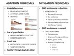
Proposals for Climate Change Adaption
In the context of climate change adaption referes to reducing the vulnerability of a biological system through certain necessary measures. Coastal erosion is currently the biggest direct threat to the area of Alexandria because it's consequences could and already have a deep negative impact on several different aspects of the case study area. All those aspects - economy, industry, tourism, agriculture, infrastructure, housing, living conditions, health, biodiversity - have a direct impact on the human population and the general standard of living. Some of our adaption proposals are as follows.
A. Coastal erosion
In the geological and topographical context Alexandria is built on a coastal plain. On this account the coastal area of Alexandria is subjected to erosion. The coastline of Alexandria can be divided into three categories (Executive summary…)[12]: 1) Seriously eroding areas – flat and low-lying coastal areas, for example western back-shore zone of Abu Quir Bay and El Tineh plain,and also delta coastal plain areas affected by subsidence. Also because of ongoing natural coastal processes the beaches of Alexandria, from Mandara to El Silcila are experiencing long term erosion of approximately 20 cm a year. 2) Artificially protected coastal areas. These areas are at risk of structural defects caused by tsunami or storms, for example, Abu Quir seawall along the Nile Delta coast. 3) Remaining areas along the Alexandria coast can be regarded as safe. Erosion caused by the climate changes endangers the first mentioned category so it is very important to find solutions to reduce this disruptive process. There could be three decent solutions for adaptation:
1. Beach Nourishment Beach nourishment is an adaption technology usually used to protect coastal area from erosion, but it also helps to reduce flooding risk. The aim of this technology is to ensure that the nourishment material is compatible with the existing natural beach material (Reeve et al., 2004). The acquisition of the beach nourishment comes from wave energy dissipation – waves loose energy when they swash the beach. Different beach profiles and gradients interact with waves to differing extent (Technologies...) [13]. There are different methods how nourishment can be deposited, for example by dredge, trucks or conveyor belts. The most popular method is to supply nourishment material by offshore dredging because it allows to move large quantities of nourishment material from an area where it's removal and transport is cautious to the shoreline (Technologies...).

Beach Nourishment principle. Sketch based on Woods Hole Group schema [14]
Beach nourishment does not stop the erosion process, but the widened and deepened beach will provide a buffer that protects coastal infrastructure and the coast line from erosion and storm damage.
2. Artificial Sand Dunes Another technology which is used to reduce coastal erosion and flooding in the coastal lowlands is artificial sand dune construction. It is possible to combine the beach nourishment and the artificial sand dunes construction (see schema above). Dunes and beaches make a united system that reacts on the changes of wind force and direction, sea level changes or wave climate (Technologies...). The simplest way of artificial dune construction is to use sediment from dredged sources on the beach. It is useful to build artificial sand dunes and beach nourishment at the same time because sand is readily available. Vegetation planting is used to strengthen artificial dunes. Vegetation promotes the accumulation of sand from windblown sources which causes growth of the dunes. This technology gives stable protection against coastal flooding and erosion (Technologies...). Artificial sand dunes also provide a valuable coastal habitat for many breeds of plants and animals.
3. Seawalls Seawalls function as a barrier for further erosion of the shoreline and also as a protection against flooding. Seawalls are built with the aim to hold or prevent sliding of the soil, and to protect the coastal area of the wave action. There are various materials that can be used for seawall building, for example steel plates, monolithic concrete barriers, brick or block walls and gabions (Kamphuis, 2000). The shape of the seaward face is important in the rejection of wave energy - smooth surfaces reflect wave energy while irregular surfaces scatter the direction of wave reflection (Technologies...).

Principles of the seawalls. Author: Ilze Draudiņa
Seawalls are often used in urban areas because they have lower space requirements than other solutions for coast protection. Seawalls may also fill the function of promenades etc. One other advantage of seawalls is that these constructions are potentially long–lived structures.
Monitoring Beach nourishment and artificial sand dunes are not permanent solutions for diminishing coastal erosion. To make these solutions sustainable there must be a monitoring system that controls whether adaptation has achieved it's goals and also assesses when new actions are necessary. All the solutions require regular maintenance and investments.
B. Local population
Helping the local inhabitants become more resilient to the negative effects of climate change should include improving the infrastructure system and housing/construction quality (to reduce floods, prevent building damage and the development of diseases) and directing further growth away from the more vulnerable areas (by raising tax on building in endangered areas and lowering tax on building in safer zones). However, people relocation can be extremely problematic so it should be carefully planned and result in the development of self sufficient satellite cities with a well integrated transportation system.
C. Land use
Because salt water intrusion causes soil salinization, activities sensitive to it should be moved further inland. Where that is not an option, a switch to less vulnerable activities should be considered (for example aquaculture and fisheries). Agricultural diversification along with safety measures (for example water harvesting during wet periods, purification and storage for use during droughts) should also be implemented with the final goal of sustainability in mind.
Implementation
Successful implementation of described measures for both helping the local inhabitants and improving land use requires effective legal regulation. Relevant existing institutions need to set the rules and prohibitions for further development and recovery of already affected areas. Possible scenarios of the effects of climate change need to be constantly assessed, new neccessary institutions established (for example ICZM – Integrated Coastal zone Management) and strategies and detailed plans made on all levels (national, regional and local).
Proposals for Climate Change Mitigation
In the context of climate change, mitigation referes to reducing greenhouse gas emissions (through for example wind energy) or their removal from the atmosphere through carbon sinks (for example urban green systems).
1. Renewable energy – wind power
Emissions of carbon dioxide (CO2) and greenhouse gases (GHG) heavily influence climate changes. It is possible to lessen the impact of these gases by reducing fossil fuel consumption. In early 1980s a renewable energy strategy was defined as an integral part of the national energy planning in Egypt (Strategy…)[15]. Many processes of climate change adaptation or mitigation are linked to bigger consumption of electric energy, for example electromobiles. Etiologically it is important to find possibilities to produce electric energy using renewable resources. Currently the strategic target is to satisfy 20% of the electric energy demand from renewable energy resources by the year 2020, including about 12% from wind power and 8% from other renewable energy resources, for example hydro power, solar energy, etc (Strategy…). This aim may be referred also to Alexandria. The wind power is considered to be the major resource of renewable energy in the national energy planning in Egypt. There are more advantages than disadvantages in use of wind energy (Advantages…)[16]:
Advantages of wind power :
• Wind energy is a perpetual resource and with modern technology it can be captured efficiently.
• Wind turbines do not cause greenhouse gases or other pollutants after they are built.
• Wind turbines require only a small plot of land.
• Well planned wind farms may become an interesting feature of the landscape.
• Wind energy may be produced for both personal use in farms or for industrial service.
• Wind turbines are comparatively accessible.
Disadvantages of wind power:
• Wind turbines do not produce a constant amount of electricity, but depend on the strength of the wind.
• Large wind farms are needed to produce enough energy for entire communities.
Conclusions: wind energy is a great renewable resource but it must be combined with other energy sources to provide a stable supply of energy. To ensure that wind farms don’t have a negative influence on the landscape, guidelines of wind farm planning must be developed.
2. Urban green systems
Green systems need to become an integral part of urban planning, spatial planning and land use planning in general. Surfaces covered with vegetation can serve as carbon sinks and remove CO2 from the atmosphere thus increasing air quality as well as urban living conditions. Open green areas in Alexandria are scarce, however their quantity could increase through designating more surfaces to be turned into parks instead of construction sites and through building green roofs where possible using plants that can endure the local climate. If planned well, these surfaces could be integrated into a valuable green system - green belt, greenway or green wedge.
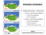
Your scenario
For most coastal regions the rising sea level due to climate change is a great challenge. The city of Alexandria is no exception. According to the IPCC third assessment report (IPCC, 2001), the sea level rise is projected to be between 15-95 cm by the year 2100 for African coastal areas. Frihy (2003) points out that climate change is not the sole reason for sea level rise, it is also caused by local tectonic activities (subsidence/emergence) and seasonal oceanographic and meteorological processes. The combined sea level rise for Alexandria is expected to be around 7.5mm (1-5 mm due to subsidence and 1.60 mm due to sea level rise) per year. If no counter measure is taken, a scenario involving a sea level rise between 0.5 m and 1.0 m over the next century is expected. With such a rise, an area of about 30% of the city will be lost due to inundation leading to environmental refugees. A 0.25 m rise in sea level would put 60% of Alexandria’s population of 4 million below sea level, as well as 56.1% of Alexandria’s industrial sector and a scenario with an expected rise of 0.5 m would see about 67% of the population, 65.9% of the industrial sector, and 75.9% of the service sector under water (see table below).

The optimistic scenario for Alexandria is one in which the use of renewable energy like wind energy become the trend of the day also refered to as the B1 (see diagram below).

Another scenario is one in which the trends of today continue and no kind of mitigation is undertaken to contain or reduce greenhouse gases. Coastal areas vulnerable to sea level rise should engage in constructing necessary protection barriers to this effect. The sea level rise and it's impact untill 2050 without any counter action is illustrated in the maps below.

What can be generalized from this case study?
The majority of coastal areas are subjected to devastation caused by the sea level rise, harsh coastal storms and strong winds. On this account coastal areas will be under rising threat of erosion and flooding and the potential for serious property damage along the coastline will increase dramatically. One more global problem is the inundation of coastal wetlands and marshes. It is critical because these territories serve important environmental functions, for example groundwater filtering, settling ground for migrating birds and also serve as foraging areas for many aquatic and terrestrial species, etc.
The climate changes generate a number of research questions:
• Is it possible to lessen the impact of climate changes that are already conspicuous?
• The struggle against climate changes may meet with an obstacle - the lack of resources and finances.
The significance of climate change adaptation and mitigation will grow in many countries. International climate change adaptation and mitigation programs must be implemented and accepted by the countries with the biggest impact on climate changes.
Presentation Slides
-
 Slide One
 -
 Slide Two
 -
 Slide Three


Image Gallery
-
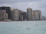 New buildings on Alexandria beaches
 -
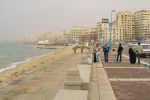 Alexandria beach buildings close up
 -
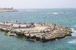 Concrete blocks used to fight coastal erosion
 -
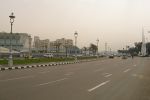 One of Alexandria's main streets
 -
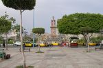 A city square in Alexandria
 -
 Alexandria harbour
 -
 Aerial view of Alexandria
 -
 Alexandria beach in 1942


References
Please add literature, documentations and weblinks
Advantages and Disadvantages of Wind Power. Retrieved January 5, 2013 from the Technology Student Website at:http://www.technologystudent.com/energy1/wind8.htm
Climate indicators in Alexandria. Retrieved December 15, 2012 from the Climate zone Website at: http://www.climate-zone.com/climate/egypt/celsius/alexandria.htm
Climate and temperature Alexandria.Retrieved December 15, 2012 from the Climatemps Website at: http://www.alexandria.climatemps.com/
Climate and temperature Egypt.15, 2012 from the Climatemps Website at:http://www.egypt.climatemps.com/
Executive summary Phase 1 Report Alexandria. Retrieved January 3, 2013 from the World bank Website at: http://arabworld.worldbank.org/content/dam/awi/pdf/Alexandria_Phase1_ExecSum.pdf
IPCC (2007). Working Group I: The Physical Science Basis, Technical Summary: The Fourth Assessment Report of the Intergovernmental Panel on Climate Change. Retrieved December 15, 2012 from the IPCC Website at: http://www.ipcc.ch/publications_and_data/publications_ipcc_fourth_assessment_report_synthesis_report.htm
Kamphuis, J.W.(2000)Introduction to Coastal Engineering and Management. Singapore: World Scientific Publishing.
Klausmeyer, K., and Shaw, R. (2009). Climate change, habitat loss, protected areas and the climate adaptation potential of species in mediterranean ecosystems worldwide. Retrieved December 11, 2012 from PLoS ONE Website at:http://www.plosone.org/article/info:doi/10.1371/journal.pone.0006392
The Mediterranean climate change. Retrieved December 10, 2012 from the Mediterranean climate change Website at: http://www.medclimatechangeinitiative.org/
Middle East flooded and Alexandria buildings collapsed by the storms in Egypt. Retrieved December 15, 2012 from the Earthe Changes and the Pole Shift Website at: http://poleshift.ning.com/profiles/blogs/middle-east-flooded-and
Reeve, D., Chadwick, A. and Fleming, C.(2004)Coastal Engineering: Processes, Theory and Design Practice. Abingdon: Spon Press.
Said, M., Moursy, Z., and Radwan A. (2006). Climatic change and sea level variations off Alexandria, Egypt. Retrieved December 14, 2012 from the WCRP website at:http://conference2011.wcrp-climate.org/abstracts/C38/Said_C38_TH16A.pdf
Shaw, R. (2010). The nature conservancy in california - Mediterranean q&a with rebecca shaw. Retrieved December 11, 2012 from The Nature Conservancy Website at: http://www.nature.org/ourinitiatives/regions/northamerica/unitedstates/california/explore/mediterranean-qa-with-rebecca-shaw.xml
Strategy & Mandate. Retrieved January 5, 2013 from New & Renewable Energy Authority Website at: http://www.nrea.gov.eg/english1.html
Technologies for Climate Change Adaptation: Coastal erosion and flooding. Retrieved January 4, 2013 from Tech Action Website at: http://tech-action.org/Guidebooks/TNA_Guidebook_AdaptationCoastalErosionFlooding.pdf
Climate Change in Egypt: Rising Sea Level, Dwindling Water Supplies, by David Sterman, July 2009. Retrieved January 13, 2013 from: http://www.climate.org/topics/international-action/egypt.html#ii
Development and climate change in Egypt: Focus on coastal resources and the Nile, Shardul Agrawala, Annett Moehner, Mohamed El Raey, Declan Conway, Maarten van Aalst, Marca Hagenstad and Joel Smith, 2004. Retrieved January 13, 2013 from: http://www.oecd.org/environment/climatechange/33330510.pdf
2.0 Climate change: Alexandria – Egypt. Retrieved January 12, 2013 from: http://switchurbanwater.lboro.ac.uk/outputs/pdfs/CALE_BRN_Climate_cahange_and_water_management_Alexandria.pdf
Sea Level Rise Impacts on the Egyptian Coastal Zone. Retrieved January 12, 2013 from: http://mdgf.referata.com/wiki/Sea_Level_Rise_Impacts_on_the_Egyptian_Coastal_Zone
About categories: You can add more categories with this tag: "", add your categories