Group R - Collaborative Climate Adaption Project: Difference between revisions
No edit summary |
No edit summary |
||
| (100 intermediate revisions by 3 users not shown) | |||
| Line 9: | Line 9: | ||
| '''Country''' || style="background:Lavender"|''India'' | | '''Country''' || style="background:Lavender"|''India'' | ||
|- | |- | ||
| '''Topic'''|| style="background:Lavender"|'' | | '''Topic'''|| style="background:Lavender"|''Climate and flooding adaptation - case study from Mumbai , India'' || | ||
|- | |- | ||
| '''Author(s)''' || style="background:Lavender"|''Nisit Chobdamrongtham, Ivankovic Dijana, Milena Ignjatijevic'' | | '''Author(s)''' || style="background:Lavender"|''Nisit Chobdamrongtham, Ivankovic Dijana, Milena Ignjatijevic'' | ||
| Line 36: | Line 36: | ||
=== Rationale: Why have you selected this case study area? === | === Rationale: Why have you selected this case study area? === | ||
We have selected the area of the city Mumbai,which is the capital city of the Indian state of Maharashtra,because this area is one of the most vulnerable region in the world to climate change. We choose this area, because impacts in India are already being seen in unprecedented heat waves, cyclones, floods, | We have selected the area of the city Mumbai,which is the capital city of the Indian state of Maharashtra,because this area is one of the most vulnerable region in the world to climate change. We choose this area, because impacts in India are already being seen in unprecedented heat waves, cyclones, floods, salinization of the coastline and effects on agriculture, fisheries and health. | ||
Challenges of urban poverty in India are intimately tied with challenges of the country’s fast development.Such high-speed, colossal growth, as impressive as it may be, poses several problems if not threats: pollution (air, soil, water), and a disproportionate concentration of poverty, among others. | Challenges of urban poverty in India are intimately tied with challenges of the country’s fast development.Such high-speed, colossal growth, as impressive as it may be, poses several problems if not threats: pollution (air, soil, water), and a disproportionate concentration of poverty, among others. | ||
| Line 55: | Line 55: | ||
Mumbai has traditional prosperity about textile mills and harbor until the 1980s. Then these are now increasingly being replaced by industries employing more skilled labor such as engineering, diamond polishing, healthcare and information technology. Presently, Mumbai is India's city which has the most population and is the financial and commercial capital of the country also serves as an economic hub. Nevertheless, Mumbai still has many unskilled and semi-skilled self-employed citizenry, who primarily earn their livelihood as hawkers, taxi drivers and mechanics. | Mumbai has traditional prosperity about textile mills and harbor until the 1980s. Then these are now increasingly being replaced by industries employing more skilled labor such as engineering, diamond polishing, healthcare and information technology. Presently, Mumbai is India's city which has the most population and is the financial and commercial capital of the country also serves as an economic hub. Nevertheless, Mumbai still has many unskilled and semi-skilled self-employed citizenry, who primarily earn their livelihood as hawkers, taxi drivers and mechanics. | ||
Mumbai suffers from the major | Mumbai suffers from the major urbanization problems that are seen in many fast growing cities in developing countries. The outcome are widespread in poverty, unemployment, poor public health, poor civic, low educational standards. With restrictive land, Mumbai residents often settle in cramped, relatively expensive housing, usually far from workplaces and therefore requiring long commutes on crowded mass transit or traffic jam roadways. By forecasting, demographers said Mumbai's people shifts are in keeping with global trends where population expectedly peaks at the initial stages of development and subsequently falls.[http://articles.timesofindia.indiatimes.com/2012-07-11/mumbai/32631701_1_population-growth-world-population-day-decline] | ||
Rapid changes in land use and occupational patterns of urban spaces in developing cities bring upfront the conflict between housing requirements and the preservation of green spaces. Mumbai, where 50% of the population lives on 8% of the land while the city has very limited green spaces except for a large urban forest. In the 1990s, settlements grew within the forest and led one environmental association to file a public interest litigation in order to protect this natural habitat. The analysis is carried out along two main lines. First, it focuses on the impact of urban governance | Rapid changes in land use and occupational patterns of urban spaces in developing cities bring upfront the conflict between housing requirements and the preservation of green spaces. Mumbai, where 50% of the population lives on 8% of the land while the city has very limited green spaces except for a large urban forest. In the 1990s, settlements grew within the forest and led one environmental association to file a public interest litigation in order to protect this natural habitat. The analysis is carried out along two main lines. First, it focuses on the impact of urban governance dis functioning on the peripheries of Indian cities. It demonstrates that peri-urban areas are used as a land reserve fund for relocation programs in order to relegate the poor outside the city central areas. Second, it explores the manner in which the relationships between the poor and the environment are framed on the conservative premises that poor encroachers were mostly responsible for the degradation of the park. Overall, the conflict underscores the constant vulnerability of the urban poor as well as their ability to challenge collectively unfavourable urban policies. New and apparently legitimate forms of urban governance, in our case the judiciary, maintain social prejudices and contribute to displace the poor to the periphery. | ||
The urban or built-up area lay down plain land almost 70% of land area along surround hilly reserved zone as green zonal area, green area is 25% of land area | The urban or built-up area lay down plain land almost 70% of land area along surround hilly reserved zone as green zonal area, green area is 25% of land area | ||
| Line 68: | Line 68: | ||
Illustrations: | Illustrations: | ||
<gallery caption=" " widths="150px" heights="150px" perrow=" | <gallery caption=" " widths="150px" heights="150px" perrow="6"> | ||
Image:Seven_Islands_of_Bombay.png| | Image:Seven_Islands_of_Bombay.png| Mumbai's region in history[http://en.wikipedia.org/wiki/File:Seven_Islands_of_Bombay_en.svg. Seven Islands of Bombay] | ||
Image:Mumbaicitydistricts.png| | Image:Mumbaicitydistricts.png|Mumbai's region in present. | ||
Image:Vegetation map.jpg|India natural vegetation map [http://maps.howstuffworks.com/india-natural-vegetation-map.htm] | Image:Vegetation map.jpg|India natural vegetation map [http://maps.howstuffworks.com/india-natural-vegetation-map.htm] | ||
Image:Mumbai4.png|The | Image:Mumbai4.png|The statistic graph of Mumbai's population in history.[http://www.newgeography.com/content/002172-the-evolving-urban-form-mumbai] | ||
Image:IMG_0434.JPG| | Image:IMG_0434.JPG|Mumbai's zoning area., sketch by Nisit C. | ||
Image:IMG_0435.JPG| | Image:IMG_0435.JPG|Mumbai's Land use., sketch by Nisit C. | ||
</gallery> | </gallery> | ||
=== Cultural/social/political context=== | === Cultural/social/political context=== | ||
'''''Culture''''' - | |||
Apart from being one of the biggest metropolitan cities in the country with the highest GDP (Gross domestic product), Indian's love it for it's blend of different languages, cuisines, food, festivals and because it provides diverse city life. Food and the festivals are the important part of Mumbai's culture and every 'Mumbaikar', as the citizens of Mumbai are often labeled, is passionate about the local celebrations like Ganesh Chathurthi, Diwali, Christmas and Eid. Also, Mumbai is known as the 'film city of India' because of Bollywood Industry. Giving that, this is the city which follows modern trends, so problems of the caste, creed and color of people are not that much apparent. | |||
Marathi is the official language of this city, but there are other languages which are popular, like Hindi, English, Urdu and the local dialect, 'Bambaiya Hindi'. This diversity also spread through different cousines adopting and transforming them into tasty dishes now unique to Mumbai. | |||
In terms of religion, Mumbai is a city of many faiths. Because of various communities and migrants, there is a mix of religions, but mostly, people of Mumbai are a concentrated mix of Hindus, Muslims, Zoroastrians, Christians, Jains and Buddhists. [http://www.mumbai.org.uk/culture.html] | |||
<gallery caption=" " widths="150px" heights="150px" perrow="6"> | |||
Image:large_5169525864.jpg|Salesman [http://www.flickr.com/photos/meanestindian/5169525864/] | |||
Image:origin_56685460.jpg|Life in Mumbai [http://www.flickr.com/photos/willemvelthoven/56685460/] | |||
Image:medium_2962705497.jpg|Food[http://www.flickr.com/photos/bijoymohan/2962705497/] | |||
Image:44979152_4daeb5bdfd_z.jpg|Festival[http://www.flickr.com/photos/ninadism/44979152/] | |||
</gallery> | |||
'''''Political economy''''' - | |||
Mumbai is called the ‘commercial capital of India’ because of its contribution to the growth of the Indian economy. Approximately 40% of state domestic production originates in it. Mumbai represents one of the most diversified and vibrant economies in the country. There are many ancillary enterprises like metal and pharmaceutical industry which are important contributors. The Mumbai's port support the industries dependent on imports of raw materials. | |||
Problems in environment caused by the ‘oppressive size’ of the city lead to deterring any growth in employment levels in Mumbai through dispersal of industries. The State Government limited the location of expansion for industries and commercial establishments resulting in declining the total population of workers in past decades. Nevertheless, the share of industrial employment remained dominant opposed to household industry, and the share of manufacturing sector had reduced. | |||
'''''Legal framework''''' - | |||
State government, according to the Indian Constitution, is responsible for formulating and executing policies for land and housing, urban development and provision of civic infrastructure. On the other hand, the central government have a important role in devolution of resources to state governments. | |||
There are different departments which are in charge of different sub departments. Therefore, urban development department is in charge of the Planning Department, Urban Development Authority, water supply and sewerage. On contrary, the Housing and Special Assistance Department is responsible for housing policy, land ceilings, rent control, slum upgrading and supervision of foreign aid projects. | |||
The most influent, and relatively most efficient local statutory body in the country is Greater Mumbai Municipal Corporation which is in charge of municipal services such as public transport and electricity and more importantly for the Master plan of the city and enforcement of development control regulations. Although is not directly involved in public housing or slum improvement, 74th Amendment to the Constitution of India has empowered urban local self-government for urban planning, poverty alleviation and other responsibilities. | |||
There are other statutory bodies like Metropolitan Development Authority (in charge of regional planning and coordinating and supervising development efforts), the Collector of Mumbai (responsible for land management aspect, issuance of identity cards to slum dwellers, the collection of service charges from them, granting of entitlements to government lands and removal of unauthorized structures from public land) and ‘Slum Rehabilitation Authority’ (responsible for reviewing the slum situation, formulating schemes for rehabilitation of slum areas and implementing the Slum Rehabilitation Scheme).[http://www.ucl.ac.uk/dpu-projects/Global_Report/pdfs/Mumbai.pdf] | |||
=== Local Climate === | === Local Climate === | ||
'''''Present conditions'''' - | |||
Mumbai (Bombay) has a tropical savanna climate with dry winters. The weather is highly influenced by the Arabic sea, and experiences a maritime climate with two main seasons, the humid and the dry season. The humid season (March - October) has high humidity and temperatures of over 30°C. October is the hottest month of the year with more than 33°C. However, as the season progresses the temperature continues to drop gradually (November < 20.5 °C). Between June and September is so-called Monsoon season, which is characterized by heavy rain and winds. Monsoons increase possibility of flooding during that period. The average total annual rainfall is 2146.6 mm (highest rainfall recorded in a single day was 944 mm in 2005). | |||
The dry season (November - February), is characterized by moderate levels of humidity and warm to cool weather. January is considered as the coolest month of the year with daily minimum - 16.4 °C and daily maximum - 28.6 °C. Cold northerly winds have influence on high wind chill factor during January and February. The annual temperatures range from a high of 38 °C to 11 °C. [http://www.mumbaiproperties.info/about-mumbai/mumbai-climate.php)] [http://www.worldweatheronline.com/Mumbai-weather-averages/Maharashtra/IN.aspx] [http://www.thisismyindia.com/about_mumbai/mumbai-climate.html] | |||
<gallery caption=" " widths="150px" heights="150px" perrow="5"> | |||
Image:Mumbai temperature and precipitation.png|Temperature and precipitation changes throughout the year[http://jon0021.edublogs.org/climate/] | |||
Image:DNI_Annual.jpg| India Solar Resource [http://headwaysolar.com/blog/2011/04/] | |||
Image:Winds India.jpg| Wind power density map [http://www.sciencedirect.com/science/article/pii/S1364032107001219] | |||
</gallery> | |||
'''''Events in the past''''' - | |||
The long coastline, Himalayan glaciers, and reliance on the monsoon for water and agriculture, makes India particularly vulnerable to the effects of climate change. Mumbai has grown quickly in recent decades, and its development that can be seen today has been built upon a landscape of overflows. Series of wetlands along with Mumbai’s Mithi River, which served as a drainage system for the annual monsoon rains, had severely shrunk (about 30% in the last 50 years) as the city has grown. | |||
Mumbai’s extreme weather event that had happened in July 2005, when more than 944 mm of rainfall, occurred in the suburban district in one day. Floods claimed more than 700 lives in the city. Until 1989, the average yearly rainfall in Mumbai was 2129 mm. However, in 2005-2006 the average annual rainfall increased to be 3214 mm. | |||
[http://urb.im/mm/121008cl] | |||
<gallery caption=" " widths="150px" heights="150px" perrow="1"> | |||
Image:Events in the past.jpg| Economic damage due to floods <ref name="past events"> Jindal, A 2011, 'Natural catastrophes in India', Irda Journal, vol. 9, no. 4, pp. 12-13 </ref> | |||
</gallery> | |||
'''''Expected changes''''' - | |||
Mega-city like Mumbai is an important center of population concentration, economic growth and innovation for the rest of the country, and its location on the coast also represents a great risk of sea-level rise, flooding, high winds, cyclones and coastal erosion. | |||
It is expected that the frequency and intensity of current hazards and the probability of extreme weather events will increase due to climate change. The cities will further face the new hazards in terms of sea-level rise. This will degrade the resilience of urban poor, which make up almost half of Mumbai’s population. | |||
There may be a general increase in both minimum and maximum temperatures by 2-4°C.The regional temperature rise, coupled with changes in the global climate system and Indian Ocean monsoon system, may lead to an increase of 7-20% in annual precipitation. | |||
Along with that, there might be an increase in heavy rainfall days and frequency but a decrease in total number of rainy days. It is expected that there might be a increase in extreme precipitation over west coast and central India. | |||
Mumbai falls into a low elevation coastal zone which leaves room for problems caused from sea level rise, cyclones and storm surges. An expected rise in sea surface temperature will induce 10-20% increase in cyclonic intensity.[http://startcc.iwlearn.org/doc/Doc_eng_16.pdf], [http://indiaenvironmentportal.org.in/files/file/extremeweathereventscroppricespikes.pdf] | |||
<gallery caption=" " widths="150px" heights="150px" perrow="6"> | |||
Image:CO2_emissions_mumbai.png|Annual CO2 emissions [http://thecityfix.com/blog/want-a-sustainable-future-act-now-to-curb-automobile-ubiquity-in-mumbai/] | |||
Image:per_capita_C02_emissions_indian_cities.png|Per capita CO2 emissions [http://thecityfix.com/blog/want-a-sustainable-future-act-now-to-curb-automobile-ubiquity-in-mumbai/] | |||
Image:PTDC0004.JPG|Mumbai city becomes Urban Heat Island., sketch by Nisit C. | |||
</gallery> | |||
=== Analysis of vulnerability === | === Analysis of vulnerability === | ||
A logical first stage of any adaptation assessment is to understand levels of current vulnerability to weather. Mumbai is prone to flooding severe disruptions almost annually. The root cause of Mumbai’s susceptibility to flooding is its geography, both natural and man-made. | |||
Firstly, the city’s location leaves it exposed to heavy rainfall during the summer. This situation is aggravated by the man-made geography; large areas of the land are reclaimed and are situated only just above sea level and below the high-tide level. This inhibits natural runoff of surface water and the complicated network of drains, rivers, creeks and ponds which drain directly in the sea, meaning that during high tides, sea water can enter the system preventing drainage and in extreme cases, leading to salt water deluge. This occurred a massive inundation of the drainage systems caused as almost 1000 mm. of rainfall fell on the city in 24 hours was combined with a failure of the system as sea water entered during high tide. | |||
Urbanization has been an important driver of increased flood risk in the city. For example, it is estimated that urbanization alone has contributed to a two or three fold increase in runoff in the city. The drainage systems of the city are now insufficient to cope with heavy rainfall and are impeded by urban encroachment and channel blockages. Continued rapid urbanization, particularly in the absence of effective spatial planning and improved drainage systems, is probable to increase in flood risk in Mumbai.<ref name="flooding"> IPCC (2007) Climate Change 2007,Gupta K (2007) Urban flood resilience planning and management and lessons for the future: a case of study in Mumbai, India. Urban Water J 4(3):183–194</ref> | |||
For Mumbai city, perhaps the most obvious increased risk from climate change comes from the increased number and intensity of extreme weather events such as heavy rainstorms, cyclones and hurricanes. The phenomenons are already common, although there is some evidence that the geographic range of some extreme weather events is expanding. | |||
The scale of the risk from these extreme weather events is also much influenced by the quality of housing and infrastructure in that city main highway routes blockade drainage directions of rain water from high profile land and along coastal line zone faced high risk from natural off-shore disasters so how well prepared the city’s population and key emergency services are. Generally, cities in high-income nations have had their risks much reduced as a result of decades of investment in housing and not well planned infrastructure in the past. | |||
So it can be concluded that main problems are: | |||
# Flooding from the ocean, monsoons and the Mithi river | |||
# Slums | |||
# Impervious surfaces | |||
# Unorganized collection of solid waste, lack of landfills | |||
# Discharge of industrial, medical and regular municipal garbage | |||
# Disturbed flow and chemical composition of the Mithi river | |||
# River bed filled with silt and garbage - endangered vegetation | |||
# Insufficient drinking water | |||
# Epidemic, infections, diseases | |||
Illustrations: | |||
<gallery caption=" " widths="150px" heights="150px" perrow="8"> | |||
Image:Annual flooding.jpg|Flooding areas, impervious ground, sewage outfalls, Dijana I. simplified map[http://pruned.blogspot.com/2009/07/rainwater-harvesting-in-mumbai.html] | |||
Image:Mumbai_effect_dia.jpg|Potential disaster and major risk of flood by nature and by man-made., sketch by Nisit C. | |||
Image:Slums.jpg|Percentage of slum population to total population in 2001. [http://sophiegberg.wordpress.com/2012/09/05/slumdog-millionaire-fact-or-fiction/mumbai-census-map-2/] | |||
Image:flooding_mumbai.jpg|Natural disaster along coastal line, Mumbai's Gateway of India on July 26, 2005.[http://www.indianweekender.co.nz] | |||
Image:flooding_mumbai2.jpg|The flood extent across the Mumbai city.[http://news.bbc.co.uk] | |||
Image:m2.jpg|Garbage [http://www.flickr.com/photos/meanestindian/5528596658/] | |||
Image:m1.jpg|place where clothes are washed[http://www.flickr.com/photos/jonhurd/2339112650/] | |||
</gallery> | |||
=== Proposals for Climate Change Adaption === | === Proposals for Climate Change Adaption === | ||
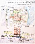
Before anything major can be done, local governments should use their authority over land use planning, waste-management, energy consumption and transportation to overcome climate change. As it is already mentioned, garbage is one of big problems in Mumbai. This garbage slows down the river's current so it can't drain away water quick enough. Therefore, the first measure should be '''water purification''', then '''revitalization of riverside''' and '''enhancement of drainage capacity''' (with structural and non structural measures). As the flooding is a natural process,it shouldn't be stopped completely because if we try to prevent a disaster in one place, it will most probably just appear in another place. So, flood adaption should be considered with a larger view of the area. In that case, people should adapt to occasional flooding but be prepared for it. One of measures could be, '''building''' important buildings in risk areas on '''higher structures''', so even when the flooding occurs, important infrastructure installations aren't influenced and there is no power shortage or drinking water isn't compromised for example. | |||
Another important thing is '''greening of the west side''' of the city with '''mangrove''' forest, an '''increase in a city greenery''' as a whole and connecting the green spaces into network. This would result in reducing the impact of floods on the west cost and on greenhouse gas emissions. If we don't fight against nature but live with it and its way, then those measure are more likely to be sustainable. | |||
Also, they have to take adaptation measures trough '''disaster management and improved infrastructure'''. Disaster management consists of ''disaster management plan'' (as part of Master plan), ''stronger database for the city'' (increased preparedness),''higher safety standards'' (for contractors and builders) and ''emergency plan''. | |||
To achieve better functioning of infrastructure measures against flooding, first initiative is to ''stop construction in risk areas'', then ''building protective hard embankment'' where is needed (flyovers, dykes), then stronger buildings and bridges.[http://saarc-sdmc.nic.in/pdf/workshops/URM/9%20June%202010/urban%20flood%20and%20climate%20change.pdf] | |||
'''SOAK project''' | |||
Our measure for adaptation is based on SOAK project which was created to resolve problems with flooding in a natural way as much as possible. This project aims to revitalize the river land and to transform it from a sewer into estuary. In the end the goal is to adapt to monsoons, not to fear them since they are connected to Mumbai forever. | |||
During the time of British rule in India, they built seawalls and embankments, deeper channels, overflow ditches and concrete levees. This measures were supposed to limit the flood to the bay area and to drain floodwater as quickly as possible. Since then, current government initiatives kept this 'train the river' approach' which is designed to keep the river between two lines on a map. | |||
Soak project considers that looking city within an estuary, it has no choice but to obey the rhythms of the sea. Mithi river "exhales” the water in a way when tides move upstream twice daily and then flow back (exhale) to the sea carrying all sorts of garbage from the city. When the flooding comes, this process of flushing is intensified and the city practically lives in its own waste. The only sustainable course is for Mumbai to be returned to its natural tendency to soak, rather than to flood. | |||
They propose few interventions at various places along the river to form natural sills and corrugated surfaces by building vegetated berms and swales that are used to gradual spillage, holding, percolation and slow absorption of water as well as effluent. Each of this proposed interventions tries to transform the Mithi basin at specific points and as a whole by taking away old lines, territories and land uses. This is a complex system which adapts to its dynamic change and seeks complete resilience. [http://www.soak.in/exhibition_intro.html][http://places.designobserver.com/feature/water-front/10227/] | |||
<gallery caption=" " widths="150px" heights="150px" perrow="4"> | |||
Image:PTDC00062.jpg|Section: Non Structure Storm Drain Networks in Mumbai, sketch by Nisit C. | |||
Image:Mumbai_wide-canal.jpg|Revitalization of riverside, sketch by Nisit C. | |||
Image:mumbai buildings.jpg|Buildings on higher structures, sketch by Nisit C. | |||
Image:adaptation.jpg| Examples of measures [http://www.docstoc.com/docs/74401561/Floods-InMumbai] | |||
</gallery> | |||
=== Proposals for Climate Change Mitigation === | === Proposals for Climate Change Mitigation === | ||
To reduce greenhouse gas emissions, the usage of fossil energy must be decreased to a minimum level using other renewable sources of energy like wind and solar energy and bio gas. Another suggestion is promoting different ways of transportation, like bicycles, which doesn't need fossil energy, then improvement of public transport (with that, the use of personal cars would be lower). | |||
Enlarging the city's greenery would result in producing more oxygen and reducing CO2 emission. | |||
As already said, floods are form of natural disaster and can't be completely avoided. So, for flood mitigation there has to be a framework. It can be classified into pre-event and post-event measures, and post-disaster measures. Pre-flood measures are consisted of mitigation for floods (data collection and analysis, vulnerability reduction) and preparation for floods (prediction, emergency preparedness, education, training and awareness).Post-flood measures are consisted of rescuing and evacuating, relief and rehabilitation and reconstruction in the end. | |||
Other than that, these measures should be taken into account: | |||
# Filtering industrial waters before discharging into river (because chemicals change the river's density) | |||
# Rainfall collectors for drinking and technical water | |||
# Revitalization of old drainage system | |||
# Protection of existing mangrove forest vegetation and swamps | |||
# Transferring horizontal slum housing into vertical housing in order to save space and increase permeable areas | |||
# Organizing private firms for garbage disposal | |||
<gallery caption=" " widths="150px" heights="150px" perrow="7"> | |||
Image:PTDC0005.JPG|Graphic of urban pattern by 2060, sketch by Nisit C. | |||
Image:PTDC0008.JPG|Mumbai, Flood Protection Network is developed from potential disaster and major risk of flood by nature and by man-made, sketch by Nisit C. | |||
</gallery> | |||
Some of measures is proposed zoning of flood prone areas as a flood mitigation strategy. After defining these areas such as flood basins or wetlands, planning authorities need to reserve it for water to accumulate there in case of flood, and forbid urbanization of these areas. The map below (Proposed zoning areas) shows different zones. Green zones represent coastal zones which are vulnerable to high tides and heavy rains, so the strategy for them is to make them open recreational spaces that can accumulate water. The development in brown zones should be guided by building codes that reduce the vulnerability of the building occupants to the adverse effects of flooding. This includes flood control devices and elevation of habitable floors of a building above expected level of flood which is shown in graphic display below. | |||
<gallery caption=" " widths="150px" heights="150px" perrow="7"> | |||
Image: Zoning-proposal.jpg| Proposed zoning areas [http://disastermanagementmumbai.blogspot.com/] | |||
Image: Building Codes.jpg| Suggested building designs [http://disastermanagementmumbai.blogspot.com/] | |||
</gallery> | |||
=== Your scenario === | === Your scenario === | ||
By 2060, change in all urban pattern development and increase in green&blue area : red area = 60 : 40 ratio is expected. Bigger green zones in the city and their network positively influenced the greenhouse emissions and given that, temperature rise and urban heat island effect is reduced. The river bed is wider, and now functioning as an estuary which works with the ocean and the water in much better drained from the city. Slum areas are more organized, and waste management is improved. | |||
The city is divided into 'islands', where every 'island' functions as a whole with its own management, landfills, evacuation programs, garbage disposals, planning department, retention and drainage system etc. Even though, 'islands' function as one, they cooperate with others. Expansion of urban greenery in a form of a green network throughout the city helps connecting these areas so they make a complete system. This program is designed to maintain better control over unwanted garbage discharge and urbanization, flood adaptation, mitigation and city as a whole. | |||
One of future developments could be a deal between government and people to relocate to outskirts of the city in exchange for the land and financial assistance until they reorganize, resulting in reduction of population density in central city area and risk sites, which would ultimately lead to decrease in climate change as the large amount of people are the main cause for all negative changes in the city. | |||
<gallery caption=" " widths="150px" heights="150px" perrow="3"> | |||
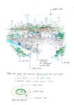
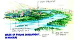
Image:PTDC0007.jpg|Mumbai's Future development with retention pond and storm drain network along highway by 2060, Sketch by Nisit C. | |||
Image:future look of the city.jpg|Mumbai in future, Sketch by Nisit C. | |||
Image:carte_mumbai1.jpg|Future development, map by Dijana I. | |||
</gallery> | |||
=== What can be generalized from this case study? === | === What can be generalized from this case study? === | ||
Mumbai is a good example how you cannot fight against nature. There are many problems of all kinds, and they are not easy to solve. Since in a war of men and nature we know who the winner is, we don't have a choice but to adapt and live with nature and its phenomena. This raises questions for research which measures should be taken to try and live with natural disasters with minimal impact on human kind. Also, how can we recover from the impact we have already made against nature? | |||
In our research we found out what are consequences when things get out of control. Even though, Mumbai is a developed city, its weaknesses overcome. The main reason are people who cannot or don't want to take care of their surroundings. So, whatever needs to be done, first we need to educate people, young people, from early age, then we will be able to really change something. | |||
“Education is the most powerful weapon which you can use to change the world.” | |||
― Nelson Mandela | |||
=== Presentation Slides === | |||
<gallery caption=" " widths="150px" heights="150px" perrow="3"> | |||
Image:City of Mumbai.jpg|Slide One | |||
Image:Problems.jpg|Slide Two | |||
Image:Adaptation and mitigation.jpg|Slide Three | |||
</gallery> | |||
=== Image Gallery === | === Image Gallery === | ||
<gallery caption=" " widths="150px" heights="150px" perrow="5"> | <gallery caption=" " widths="150px" heights="150px" perrow="5"> | ||
Image: | Image:slum.jpg|Look from a 5 star hotel to a slum area [http://www.flickr.com/photos/s_w_ellis/3942274790/] | ||
Image: | Image:flood2q.jpg|Cars covered in water [http://www.flickr.com/photos/apoorvak/2289624709/] | ||
Image: | Image:deliver.jpg|Man despite water runs to deliver something [http://www.flickr.com/photos/hussain_quantum/3698717526/] | ||
Image: | Image:common thing.jpg|People ignoring water[http://www.flickr.com/photos/chijs/951652286/] | ||
Image: | Image:musician.jpg|Street musician [http://www.flickr.com/photos/gargi/98526925/] | ||
Image: | Image:large_1.jpg|[http://www.flickr.com/photos/gargi/1438579998/] | ||
Image: | Image:spices.jpg|Market[http://www.flickr.com/photos/bmwguggenheimlab/8346898656/] | ||
Image: | Image:clay.jpg|Making pots [http://www.flickr.com/photos/gargi/6818959182/] | ||
Image:Mumbai_at_dawn_-_Choking.jpg|Smoke from a factory [http://www.flickr.com/photos/tawheedmanzoor/2456217852/] | |||
</gallery> | </gallery> | ||
=== References === | === References === | ||
<references/> | <references/> | ||
---- | ---- | ||
[[Category:Climate Change Case Study]] | [[Category:Climate Change Case Study]] | ||
About categories: You can add more categories with this tag: "[[Category:Category Name]]", add your categories | About categories: You can add more categories with this tag: "[[Category:Category Name]]", add your categories | ||
Latest revision as of 17:06, 22 January 2013
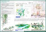
| Place | Mumbai (Bombay) | |||||||||||
| Country | India | |||||||||||
| Topic | Climate and flooding adaptation - case study from Mumbai , India | |||||||||||
| Author(s) | Nisit Chobdamrongtham, Ivankovic Dijana, Milena Ignjatijevic | |||||||||||

| ||||||||||||
| Source | http://www.corfu-fp7.eu/home/page2894.html | |||||||||||
| {{#widget:GoogleMaps | width=300 | height=200 | lat=18.5830 | lng=72.4933 | zoom=5 | centermarker=yes | maptypecontrol=yes | overviewmapcontrol=yes | largemapcontrol=yes | scalecontrol=yes
}} | ||
Rationale: Why have you selected this case study area?
We have selected the area of the city Mumbai,which is the capital city of the Indian state of Maharashtra,because this area is one of the most vulnerable region in the world to climate change. We choose this area, because impacts in India are already being seen in unprecedented heat waves, cyclones, floods, salinization of the coastline and effects on agriculture, fisheries and health. Challenges of urban poverty in India are intimately tied with challenges of the country’s fast development.Such high-speed, colossal growth, as impressive as it may be, poses several problems if not threats: pollution (air, soil, water), and a disproportionate concentration of poverty, among others.
Authors' perspectives
Whether they are induced by human action or the natural cycle of the planet earth, experts agree on one thing, climate change must be seen as a serious threat to the sustainable development of mankind, with the expected adverse effects to the environment, human health, access to food and natural resources, economic and physical infrastructure. As landscape architects who are closely associated with climate, we should be involved in finding new ways to fight against the consequences of its disruption.
Landscape and/or urban context
Mumbai is the second largest city in the world, and the biggest city in India. It was named a Global City in 2009 and it's most dense megalopolis in the world. Аn increasing number of India’s population are moving to urban centers and now, the average density surpasses 27,000 people per km². It is not unusual that Mumbai’s slums accommodate as many as 100,000 persons per km².
The urban image of Mumbai is one of extremes. On one hand, images of slum dwellers living in substandard conditions are synonymous with the city, yet on the other hand, luxury developments and tall buildings are becoming an increasingly prominent part of the city. These contrasts strongly impact the urban sustainability and economy debate both in local and global discussions. [30]
Historically, Mumbai was formed by land reclamation projects of seven islands which are located on the western coast of India. Mumbai is surrounding with the Arabian Sea. Many parts of the city stand around 10 - 15 m above sea level(average elevation is 14 m). Northern Mumbai(Mumbai Suburban District; Salsette Island) is hilly and the highest point is merely 450 m. There are six major lakes that supply water to the city including three small rivers are situated in Borivili National Park, within the city's limits, one supply from the lake is used only for agricultural and industrial purposes. The coastline of the city is indented with numerous creeks and bays. The eastern coast of Mumbai is covered with large mangrove swamps which are fully in biodiversity while the western coast is mostly sandy and rocky. Soil cover in the city area is affected from sandy near to the sea. In the suburbs, the soil cover is mainly alluvium and loam. Furthermore, Mumbai sits on a seismically active zone is classified as a Seismic Zone III region that means it has possibilities to occur an earthquake up to 6.5 Richter.[source:India Meteorological Department. Seismic Zoning Map (Map). Retrieved 20 July 2008.]
Mumbai has traditional prosperity about textile mills and harbor until the 1980s. Then these are now increasingly being replaced by industries employing more skilled labor such as engineering, diamond polishing, healthcare and information technology. Presently, Mumbai is India's city which has the most population and is the financial and commercial capital of the country also serves as an economic hub. Nevertheless, Mumbai still has many unskilled and semi-skilled self-employed citizenry, who primarily earn their livelihood as hawkers, taxi drivers and mechanics.
Mumbai suffers from the major urbanization problems that are seen in many fast growing cities in developing countries. The outcome are widespread in poverty, unemployment, poor public health, poor civic, low educational standards. With restrictive land, Mumbai residents often settle in cramped, relatively expensive housing, usually far from workplaces and therefore requiring long commutes on crowded mass transit or traffic jam roadways. By forecasting, demographers said Mumbai's people shifts are in keeping with global trends where population expectedly peaks at the initial stages of development and subsequently falls.[31]
Rapid changes in land use and occupational patterns of urban spaces in developing cities bring upfront the conflict between housing requirements and the preservation of green spaces. Mumbai, where 50% of the population lives on 8% of the land while the city has very limited green spaces except for a large urban forest. In the 1990s, settlements grew within the forest and led one environmental association to file a public interest litigation in order to protect this natural habitat. The analysis is carried out along two main lines. First, it focuses on the impact of urban governance dis functioning on the peripheries of Indian cities. It demonstrates that peri-urban areas are used as a land reserve fund for relocation programs in order to relegate the poor outside the city central areas. Second, it explores the manner in which the relationships between the poor and the environment are framed on the conservative premises that poor encroachers were mostly responsible for the degradation of the park. Overall, the conflict underscores the constant vulnerability of the urban poor as well as their ability to challenge collectively unfavourable urban policies. New and apparently legitimate forms of urban governance, in our case the judiciary, maintain social prejudices and contribute to displace the poor to the periphery.
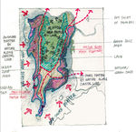
The urban or built-up area lay down plain land almost 70% of land area along surround hilly reserved zone as green zonal area, green area is 25% of land area the other shall be blue area which include wetland and coastal forest about less than 5% of total land area[1] [2].
                     Ratio of green : blue  =  5 : 1
                     Ratio of sealed : built-up = 2.3 : 1
Illustrations:
-
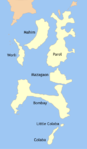 Mumbai's region in historySeven Islands of Bombay
 -
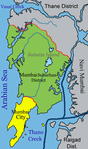 Mumbai's region in present.
 -
![India natural vegetation map [1]](/images/thumb/3/34/Vegetation_map.jpg/150px-Vegetation_map.jpg) India natural vegetation map [1]
India natural vegetation map [1] -
![The statistic graph of Mumbai's population in history.[2]](/images/thumb/b/bf/Mumbai4.png/150px-Mumbai4.png) The statistic graph of Mumbai's population in history.[2]
The statistic graph of Mumbai's population in history.[2] -
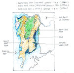 Mumbai's zoning area., sketch by Nisit C.
 -
 Mumbai's Land use., sketch by Nisit C.


![India natural vegetation map [1]](/index.php?title=File:Vegetation_map.jpg)
![The statistic graph of Mumbai's population in history.[2]](/index.php?title=File:Mumbai4.png)


Cultural/social/political context
Culture - Apart from being one of the biggest metropolitan cities in the country with the highest GDP (Gross domestic product), Indian's love it for it's blend of different languages, cuisines, food, festivals and because it provides diverse city life. Food and the festivals are the important part of Mumbai's culture and every 'Mumbaikar', as the citizens of Mumbai are often labeled, is passionate about the local celebrations like Ganesh Chathurthi, Diwali, Christmas and Eid. Also, Mumbai is known as the 'film city of India' because of Bollywood Industry. Giving that, this is the city which follows modern trends, so problems of the caste, creed and color of people are not that much apparent.
Marathi is the official language of this city, but there are other languages which are popular, like Hindi, English, Urdu and the local dialect, 'Bambaiya Hindi'. This diversity also spread through different cousines adopting and transforming them into tasty dishes now unique to Mumbai.
In terms of religion, Mumbai is a city of many faiths. Because of various communities and migrants, there is a mix of religions, but mostly, people of Mumbai are a concentrated mix of Hindus, Muslims, Zoroastrians, Christians, Jains and Buddhists. [32]
![Salesman [3]](/index.php?title=File:Large_5169525864.jpg)
![Life in Mumbai [4]](/index.php?title=File:Origin_56685460.jpg)
![Food[5]](/index.php?title=File:Medium_2962705497.jpg)
![Festival[6]](/index.php?title=File:44979152_4daeb5bdfd_z.jpg)
Political economy -
Mumbai is called the ‘commercial capital of India’ because of its contribution to the growth of the Indian economy. Approximately 40% of state domestic production originates in it. Mumbai represents one of the most diversified and vibrant economies in the country. There are many ancillary enterprises like metal and pharmaceutical industry which are important contributors. The Mumbai's port support the industries dependent on imports of raw materials.
Problems in environment caused by the ‘oppressive size’ of the city lead to deterring any growth in employment levels in Mumbai through dispersal of industries. The State Government limited the location of expansion for industries and commercial establishments resulting in declining the total population of workers in past decades. Nevertheless, the share of industrial employment remained dominant opposed to household industry, and the share of manufacturing sector had reduced.
Legal framework -
State government, according to the Indian Constitution, is responsible for formulating and executing policies for land and housing, urban development and provision of civic infrastructure. On the other hand, the central government have a important role in devolution of resources to state governments.
There are different departments which are in charge of different sub departments. Therefore, urban development department is in charge of the Planning Department, Urban Development Authority, water supply and sewerage. On contrary, the Housing and Special Assistance Department is responsible for housing policy, land ceilings, rent control, slum upgrading and supervision of foreign aid projects.
The most influent, and relatively most efficient local statutory body in the country is Greater Mumbai Municipal Corporation which is in charge of municipal services such as public transport and electricity and more importantly for the Master plan of the city and enforcement of development control regulations. Although is not directly involved in public housing or slum improvement, 74th Amendment to the Constitution of India has empowered urban local self-government for urban planning, poverty alleviation and other responsibilities.
There are other statutory bodies like Metropolitan Development Authority (in charge of regional planning and coordinating and supervising development efforts), the Collector of Mumbai (responsible for land management aspect, issuance of identity cards to slum dwellers, the collection of service charges from them, granting of entitlements to government lands and removal of unauthorized structures from public land) and ‘Slum Rehabilitation Authority’ (responsible for reviewing the slum situation, formulating schemes for rehabilitation of slum areas and implementing the Slum Rehabilitation Scheme).[33]
Local Climate
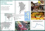
Present conditions' - Mumbai (Bombay) has a tropical savanna climate with dry winters. The weather is highly influenced by the Arabic sea, and experiences a maritime climate with two main seasons, the humid and the dry season. The humid season (March - October) has high humidity and temperatures of over 30°C. October is the hottest month of the year with more than 33°C. However, as the season progresses the temperature continues to drop gradually (November < 20.5 °C). Between June and September is so-called Monsoon season, which is characterized by heavy rain and winds. Monsoons increase possibility of flooding during that period. The average total annual rainfall is 2146.6 mm (highest rainfall recorded in a single day was 944 mm in 2005).
The dry season (November - February), is characterized by moderate levels of humidity and warm to cool weather. January is considered as the coolest month of the year with daily minimum - 16.4 °C and daily maximum - 28.6 °C. Cold northerly winds have influence on high wind chill factor during January and February. The annual temperatures range from a high of 38 °C to 11 °C. [34] [35] [36]
-
![Temperature and precipitation changes throughout the year[7]](/images/thumb/3/3b/Mumbai_temperature_and_precipitation.png/150px-Mumbai_temperature_and_precipitation.png) Temperature and precipitation changes throughout the year[7]
Temperature and precipitation changes throughout the year[7] -
![India Solar Resource [8]](/images/thumb/f/fe/DNI_Annual.jpg/116px-DNI_Annual.jpg) India Solar Resource [8]
India Solar Resource [8] -
![Wind power density map [9]](/images/thumb/1/1d/Winds_India.jpg/120px-Winds_India.jpg) Wind power density map [9]
Wind power density map [9]
![Temperature and precipitation changes throughout the year[7]](/index.php?title=File:Mumbai_temperature_and_precipitation.png)
![India Solar Resource [8]](/index.php?title=File:DNI_Annual.jpg)
![Wind power density map [9]](/index.php?title=File:Winds_India.jpg)
Events in the past - The long coastline, Himalayan glaciers, and reliance on the monsoon for water and agriculture, makes India particularly vulnerable to the effects of climate change. Mumbai has grown quickly in recent decades, and its development that can be seen today has been built upon a landscape of overflows. Series of wetlands along with Mumbai’s Mithi River, which served as a drainage system for the annual monsoon rains, had severely shrunk (about 30% in the last 50 years) as the city has grown.
Mumbai’s extreme weather event that had happened in July 2005, when more than 944 mm of rainfall, occurred in the suburban district in one day. Floods claimed more than 700 lives in the city. Until 1989, the average yearly rainfall in Mumbai was 2129 mm. However, in 2005-2006 the average annual rainfall increased to be 3214 mm. [37]
-
![Economic damage due to floods [3]](/images/thumb/7/7b/Events_in_the_past.jpg/150px-Events_in_the_past.jpg) Economic damage due to floods [3]
Economic damage due to floods [3]
![Economic damage due to floods [3]](/index.php?title=File:Events_in_the_past.jpg)
Expected changes - Mega-city like Mumbai is an important center of population concentration, economic growth and innovation for the rest of the country, and its location on the coast also represents a great risk of sea-level rise, flooding, high winds, cyclones and coastal erosion.
It is expected that the frequency and intensity of current hazards and the probability of extreme weather events will increase due to climate change. The cities will further face the new hazards in terms of sea-level rise. This will degrade the resilience of urban poor, which make up almost half of Mumbai’s population. There may be a general increase in both minimum and maximum temperatures by 2-4°C.The regional temperature rise, coupled with changes in the global climate system and Indian Ocean monsoon system, may lead to an increase of 7-20% in annual precipitation.
Along with that, there might be an increase in heavy rainfall days and frequency but a decrease in total number of rainy days. It is expected that there might be a increase in extreme precipitation over west coast and central India. Mumbai falls into a low elevation coastal zone which leaves room for problems caused from sea level rise, cyclones and storm surges. An expected rise in sea surface temperature will induce 10-20% increase in cyclonic intensity.[38], [39]
-
![Annual CO2 emissions [10]](/images/thumb/8/8c/CO2_emissions_mumbai.png/150px-CO2_emissions_mumbai.png) Annual CO2 emissions [10]
Annual CO2 emissions [10] -
![Per capita CO2 emissions [11]](/images/thumb/8/88/Per_capita_C02_emissions_indian_cities.png/150px-Per_capita_C02_emissions_indian_cities.png) Per capita CO2 emissions [11]
Per capita CO2 emissions [11] -
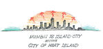 Mumbai city becomes Urban Heat Island., sketch by Nisit C.
![Annual CO2 emissions [10]](/index.php?title=File:CO2_emissions_mumbai.png)
![Per capita CO2 emissions [11]](/index.php?title=File:Per_capita_C02_emissions_indian_cities.png)

Analysis of vulnerability
A logical first stage of any adaptation assessment is to understand levels of current vulnerability to weather. Mumbai is prone to flooding severe disruptions almost annually. The root cause of Mumbai’s susceptibility to flooding is its geography, both natural and man-made.
Firstly, the city’s location leaves it exposed to heavy rainfall during the summer. This situation is aggravated by the man-made geography; large areas of the land are reclaimed and are situated only just above sea level and below the high-tide level. This inhibits natural runoff of surface water and the complicated network of drains, rivers, creeks and ponds which drain directly in the sea, meaning that during high tides, sea water can enter the system preventing drainage and in extreme cases, leading to salt water deluge. This occurred a massive inundation of the drainage systems caused as almost 1000 mm. of rainfall fell on the city in 24 hours was combined with a failure of the system as sea water entered during high tide.
Urbanization has been an important driver of increased flood risk in the city. For example, it is estimated that urbanization alone has contributed to a two or three fold increase in runoff in the city. The drainage systems of the city are now insufficient to cope with heavy rainfall and are impeded by urban encroachment and channel blockages. Continued rapid urbanization, particularly in the absence of effective spatial planning and improved drainage systems, is probable to increase in flood risk in Mumbai.[4]
For Mumbai city, perhaps the most obvious increased risk from climate change comes from the increased number and intensity of extreme weather events such as heavy rainstorms, cyclones and hurricanes. The phenomenons are already common, although there is some evidence that the geographic range of some extreme weather events is expanding.
The scale of the risk from these extreme weather events is also much influenced by the quality of housing and infrastructure in that city main highway routes blockade drainage directions of rain water from high profile land and along coastal line zone faced high risk from natural off-shore disasters so how well prepared the city’s population and key emergency services are. Generally, cities in high-income nations have had their risks much reduced as a result of decades of investment in housing and not well planned infrastructure in the past.
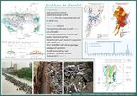
So it can be concluded that main problems are:
- Flooding from the ocean, monsoons and the Mithi river
- Slums
- Impervious surfaces
- Unorganized collection of solid waste, lack of landfills
- Discharge of industrial, medical and regular municipal garbage
- Disturbed flow and chemical composition of the Mithi river
- River bed filled with silt and garbage - endangered vegetation
- Insufficient drinking water
- Epidemic, infections, diseases
Illustrations:
-
![Flooding areas, impervious ground, sewage outfalls, Dijana I. simplified map[12]](/images/thumb/4/47/Annual_flooding.jpg/104px-Annual_flooding.jpg) Flooding areas, impervious ground, sewage outfalls, Dijana I. simplified map[12]
Flooding areas, impervious ground, sewage outfalls, Dijana I. simplified map[12] -
 Potential disaster and major risk of flood by nature and by man-made., sketch by Nisit C.
 -
![Percentage of slum population to total population in 2001. [13]](/images/thumb/0/00/Slums.jpg/104px-Slums.jpg) Percentage of slum population to total population in 2001. [13]
Percentage of slum population to total population in 2001. [13] -
![Natural disaster along coastal line, Mumbai's Gateway of India on July 26, 2005.[14]](/images/thumb/7/7c/Flooding_mumbai.jpg/150px-Flooding_mumbai.jpg) Natural disaster along coastal line, Mumbai's Gateway of India on July 26, 2005.[14]
Natural disaster along coastal line, Mumbai's Gateway of India on July 26, 2005.[14] -
![The flood extent across the Mumbai city.[15]](/images/thumb/0/01/Flooding_mumbai2.jpg/150px-Flooding_mumbai2.jpg) The flood extent across the Mumbai city.[15]
The flood extent across the Mumbai city.[15] -
![Garbage [16]](/images/thumb/c/cd/M2.jpg/150px-M2.jpg) Garbage [16]
Garbage [16] -
![place where clothes are washed[17]](/images/thumb/d/db/M1.jpg/150px-M1.jpg) place where clothes are washed[17]
place where clothes are washed[17]
![Flooding areas, impervious ground, sewage outfalls, Dijana I. simplified map[12]](/index.php?title=File:Annual_flooding.jpg)

![Percentage of slum population to total population in 2001. [13]](/index.php?title=File:Slums.jpg)
![Natural disaster along coastal line, Mumbai's Gateway of India on July 26, 2005.[14]](/index.php?title=File:Flooding_mumbai.jpg)
![The flood extent across the Mumbai city.[15]](/index.php?title=File:Flooding_mumbai2.jpg)
![Garbage [16]](/index.php?title=File:M2.jpg)
![place where clothes are washed[17]](/index.php?title=File:M1.jpg)
Proposals for Climate Change Adaption
Before anything major can be done, local governments should use their authority over land use planning, waste-management, energy consumption and transportation to overcome climate change. As it is already mentioned, garbage is one of big problems in Mumbai. This garbage slows down the river's current so it can't drain away water quick enough. Therefore, the first measure should be water purification, then revitalization of riverside and enhancement of drainage capacity (with structural and non structural measures). As the flooding is a natural process,it shouldn't be stopped completely because if we try to prevent a disaster in one place, it will most probably just appear in another place. So, flood adaption should be considered with a larger view of the area. In that case, people should adapt to occasional flooding but be prepared for it. One of measures could be, building important buildings in risk areas on higher structures, so even when the flooding occurs, important infrastructure installations aren't influenced and there is no power shortage or drinking water isn't compromised for example. Another important thing is greening of the west side of the city with mangrove forest, an increase in a city greenery as a whole and connecting the green spaces into network. This would result in reducing the impact of floods on the west cost and on greenhouse gas emissions. If we don't fight against nature but live with it and its way, then those measure are more likely to be sustainable.
Also, they have to take adaptation measures trough disaster management and improved infrastructure. Disaster management consists of disaster management plan (as part of Master plan), stronger database for the city (increased preparedness),higher safety standards (for contractors and builders) and emergency plan. To achieve better functioning of infrastructure measures against flooding, first initiative is to stop construction in risk areas, then building protective hard embankment where is needed (flyovers, dykes), then stronger buildings and bridges.[40]
SOAK project
Our measure for adaptation is based on SOAK project which was created to resolve problems with flooding in a natural way as much as possible. This project aims to revitalize the river land and to transform it from a sewer into estuary. In the end the goal is to adapt to monsoons, not to fear them since they are connected to Mumbai forever. During the time of British rule in India, they built seawalls and embankments, deeper channels, overflow ditches and concrete levees. This measures were supposed to limit the flood to the bay area and to drain floodwater as quickly as possible. Since then, current government initiatives kept this 'train the river' approach' which is designed to keep the river between two lines on a map. Soak project considers that looking city within an estuary, it has no choice but to obey the rhythms of the sea. Mithi river "exhales” the water in a way when tides move upstream twice daily and then flow back (exhale) to the sea carrying all sorts of garbage from the city. When the flooding comes, this process of flushing is intensified and the city practically lives in its own waste. The only sustainable course is for Mumbai to be returned to its natural tendency to soak, rather than to flood. They propose few interventions at various places along the river to form natural sills and corrugated surfaces by building vegetated berms and swales that are used to gradual spillage, holding, percolation and slow absorption of water as well as effluent. Each of this proposed interventions tries to transform the Mithi basin at specific points and as a whole by taking away old lines, territories and land uses. This is a complex system which adapts to its dynamic change and seeks complete resilience. [41][42]
-
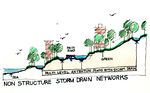 Section: Non Structure Storm Drain Networks in Mumbai, sketch by Nisit C.
 -
 Revitalization of riverside, sketch by Nisit C.
 -
 Buildings on higher structures, sketch by Nisit C.
 -
![Examples of measures [18]](/images/thumb/0/03/Adaptation.jpg/95px-Adaptation.jpg) Examples of measures [18]
Examples of measures [18]


![Examples of measures [18]](/index.php?title=File:Adaptation.jpg)
Proposals for Climate Change Mitigation
To reduce greenhouse gas emissions, the usage of fossil energy must be decreased to a minimum level using other renewable sources of energy like wind and solar energy and bio gas. Another suggestion is promoting different ways of transportation, like bicycles, which doesn't need fossil energy, then improvement of public transport (with that, the use of personal cars would be lower). Enlarging the city's greenery would result in producing more oxygen and reducing CO2 emission. As already said, floods are form of natural disaster and can't be completely avoided. So, for flood mitigation there has to be a framework. It can be classified into pre-event and post-event measures, and post-disaster measures. Pre-flood measures are consisted of mitigation for floods (data collection and analysis, vulnerability reduction) and preparation for floods (prediction, emergency preparedness, education, training and awareness).Post-flood measures are consisted of rescuing and evacuating, relief and rehabilitation and reconstruction in the end.
Other than that, these measures should be taken into account:
- Filtering industrial waters before discharging into river (because chemicals change the river's density)
- Rainfall collectors for drinking and technical water
- Revitalization of old drainage system
- Protection of existing mangrove forest vegetation and swamps
- Transferring horizontal slum housing into vertical housing in order to save space and increase permeable areas
- Organizing private firms for garbage disposal
-
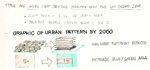 Graphic of urban pattern by 2060, sketch by Nisit C.
 -
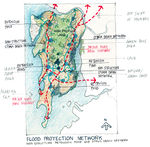 Mumbai, Flood Protection Network is developed from potential disaster and major risk of flood by nature and by man-made, sketch by Nisit C.


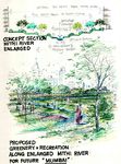
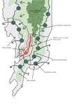
Some of measures is proposed zoning of flood prone areas as a flood mitigation strategy. After defining these areas such as flood basins or wetlands, planning authorities need to reserve it for water to accumulate there in case of flood, and forbid urbanization of these areas. The map below (Proposed zoning areas) shows different zones. Green zones represent coastal zones which are vulnerable to high tides and heavy rains, so the strategy for them is to make them open recreational spaces that can accumulate water. The development in brown zones should be guided by building codes that reduce the vulnerability of the building occupants to the adverse effects of flooding. This includes flood control devices and elevation of habitable floors of a building above expected level of flood which is shown in graphic display below.
![Proposed zoning areas [19]](/index.php?title=File:Zoning-proposal.jpg)
![Suggested building designs [20]](/index.php?title=File:Building_Codes.jpg)
Your scenario
By 2060, change in all urban pattern development and increase in green&blue area : red area = 60 : 40 ratio is expected. Bigger green zones in the city and their network positively influenced the greenhouse emissions and given that, temperature rise and urban heat island effect is reduced. The river bed is wider, and now functioning as an estuary which works with the ocean and the water in much better drained from the city. Slum areas are more organized, and waste management is improved.
The city is divided into 'islands', where every 'island' functions as a whole with its own management, landfills, evacuation programs, garbage disposals, planning department, retention and drainage system etc. Even though, 'islands' function as one, they cooperate with others. Expansion of urban greenery in a form of a green network throughout the city helps connecting these areas so they make a complete system. This program is designed to maintain better control over unwanted garbage discharge and urbanization, flood adaptation, mitigation and city as a whole.
One of future developments could be a deal between government and people to relocate to outskirts of the city in exchange for the land and financial assistance until they reorganize, resulting in reduction of population density in central city area and risk sites, which would ultimately lead to decrease in climate change as the large amount of people are the main cause for all negative changes in the city.
-
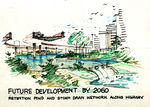 Mumbai's Future development with retention pond and storm drain network along highway by 2060, Sketch by Nisit C.
 -
 Mumbai in future, Sketch by Nisit C.
 -
 Future development, map by Dijana I.


What can be generalized from this case study?
Mumbai is a good example how you cannot fight against nature. There are many problems of all kinds, and they are not easy to solve. Since in a war of men and nature we know who the winner is, we don't have a choice but to adapt and live with nature and its phenomena. This raises questions for research which measures should be taken to try and live with natural disasters with minimal impact on human kind. Also, how can we recover from the impact we have already made against nature?
In our research we found out what are consequences when things get out of control. Even though, Mumbai is a developed city, its weaknesses overcome. The main reason are people who cannot or don't want to take care of their surroundings. So, whatever needs to be done, first we need to educate people, young people, from early age, then we will be able to really change something.
“Education is the most powerful weapon which you can use to change the world.” ― Nelson Mandela
Presentation Slides
-
 Slide One
 -
 Slide Two
 -
 Slide Three


Image Gallery
-
![Look from a 5 star hotel to a slum area [21]](/images/thumb/a/ac/Slum.jpg/150px-Slum.jpg) Look from a 5 star hotel to a slum area [21]
Look from a 5 star hotel to a slum area [21] -
![Cars covered in water [22]](/images/thumb/7/7a/Flood2q.jpg/150px-Flood2q.jpg) Cars covered in water [22]
Cars covered in water [22] -
![Man despite water runs to deliver something [23]](/images/thumb/7/7e/Deliver.jpg/150px-Deliver.jpg) Man despite water runs to deliver something [23]
Man despite water runs to deliver something [23] -
![People ignoring water[24]](/images/thumb/d/d9/Common_thing.jpg/150px-Common_thing.jpg) People ignoring water[24]
People ignoring water[24] -
![Street musician [25]](/images/thumb/0/0e/Musician.jpg/150px-Musician.jpg) Street musician [25]
Street musician [25] -
![[26]](/images/thumb/2/2c/Large_1.jpg/101px-Large_1.jpg)
-
![Market[27]](/images/thumb/7/7c/Spices.jpg/150px-Spices.jpg) Market[27]
Market[27] -
![Making pots [28]](/images/thumb/4/42/Clay.jpg/150px-Clay.jpg) Making pots [28]
Making pots [28] -
![Smoke from a factory [29]](/images/thumb/c/cf/Mumbai_at_dawn_-_Choking.jpg/150px-Mumbai_at_dawn_-_Choking.jpg) Smoke from a factory [29]
Smoke from a factory [29]
![Look from a 5 star hotel to a slum area [21]](/index.php?title=File:Slum.jpg)
![Cars covered in water [22]](/index.php?title=File:Flood2q.jpg)
![Man despite water runs to deliver something [23]](/index.php?title=File:Deliver.jpg)
![People ignoring water[24]](/index.php?title=File:Common_thing.jpg)
![Street musician [25]](/index.php?title=File:Musician.jpg)
![[26]](/index.php?title=File:Large_1.jpg)
![Market[27]](/index.php?title=File:Spices.jpg)
![Making pots [28]](/index.php?title=File:Clay.jpg)
![Smoke from a factory [29]](/index.php?title=File:Mumbai_at_dawn_-_Choking.jpg)
References
- ↑ Regional Plan for Mumbai Metropolitan Area 1996-2011/Mumbai/Bombay pages
- ↑ Environment&Urbanization Copyright 2007 International Institute for Environment and Development (IIED)
- ↑ Jindal, A 2011, 'Natural catastrophes in India', Irda Journal, vol. 9, no. 4, pp. 12-13
- ↑ IPCC (2007) Climate Change 2007,Gupta K (2007) Urban flood resilience planning and management and lessons for the future: a case of study in Mumbai, India. Urban Water J 4(3):183–194
About categories: You can add more categories with this tag: "", add your categories