Group D - Collaborative Climate Adaption Project: Difference between revisions
No edit summary |
|||
| (115 intermediate revisions by 3 users not shown) | |||
| Line 40: | Line 40: | ||
* As landscape architecs we have an important role to play defining policies (i.e. urban ordinances) designing and applying strategies to improve urban design to preserve the core value of the Cultural Landscape of Aranjuez represented by the historical Gardens of Aranjuez linked to the Royal Palace. Also it is necessary to define policies for landscaping and integrating vegetation regarding other places of the city. | * As landscape architecs we have an important role to play defining policies (i.e. urban ordinances) designing and applying strategies to improve urban design to preserve the core value of the Cultural Landscape of Aranjuez represented by the historical Gardens of Aranjuez linked to the Royal Palace. Also it is necessary to define policies for landscaping and integrating vegetation regarding other places of the city. | ||
=== | === LANDSCAPE AND/OR URBAN CONTEST=== | ||
Map; | <gallery caption=" " widths="150px" heights="150px" perrow="5"> | ||
Image:Population In Aranjuez.jpg |Population in Aranjuez.jpg | |||
Image:Aranjuez Land Categories.jpg|Land Categories in Aranjuez.jpg | |||
Image:Agrologic classes map 1_100000.jpg|Agrologic classes 1_100000 | |||
Image:Biodiversity map_species number.jpg|Biodiversity species range | |||
Image:Clinometric model map 1_100000.jpg|Clinometric model 1_100000 | |||
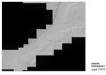
Image:Shaded topography map 1_100000.jpg|Shaded topography 1_100000 | |||
Image:Crops map.jpg|Crops | |||
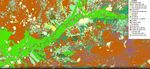
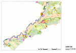
Image:Land Use map 1_100000.jpg|Land Use map 1_100000 | |||
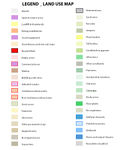
Image:Legend Land Use Map.jpg|Legend Land Use | |||
Image:Nature Protected Areas map.jpg|Nature Protected Areas | |||
Image:Rural tracks map.jpg|Rural tracks | |||
Image:Nature Protected Areas map.jpg|Nature Protected Areas map | |||
Image:Barrios_aranjuez.png|Aranjuez Districts | |||
</gallery> | |||
== History == | |||
Aranjuez it was the name of an ancient pasture that was understanding, approximately, the lands located among the Tajo and the Sea of Ontígola, of north to south, and the Street of the King and the Bare of the Star, of this to west. In the term of the ancient pasture, were found the village of Aranz, about the gasket of the Tajo rivers and Jarama. From the times of Felipe II, the name of Aranjuez served to designate to the Place, thereinafter Royal Place and, from the reign of Fernando VI, name of the population that here was seated. | |||
The Aranjuez area enjoyed a long history of human settlement before becoming a strategic stronghold during Roman times. Then its position at a river crossing and cross roads - a factor to be repeatedly influential - gave it a significance in the political geography of the time. It lay in a sparsely populated region thereafter and was eventually granted by the Crown to the military order of St James of Santiago in the medieval period. Towards the end of the 14th century, the knights built a palace in the middle of the woods, then replete with game. | |||
Aranjuez became a Royal site in the 15th century, but it was Philip II in the 16th century who created the first period of splendour. He built a new palace and large ornamental and vegetable gardens laid out according to geometric principles, attempting to symbolize his world-wide imperial sovereignty based on a centralized state while at the same time celebrating a return to nature, its structure, and man's supremacy according to the canons of Humanism. It was also a private and personal retreat. Phillip meanwhile pursued botanical experimentation, acclimatizing plant species from all over the world, and introduced hydraulic engineering based on best practice in central Europe and Italy. During the 17th century Aranjuez prospered as the annual abode of royalty, a place of pageantry and hunting, and a source of inspiration for and patronage of some of the greatest Spanish poets of the Golden Age. | |||
The continuing splendour of the 18th century culminated in the building of a new town close to the palace. During the reign of Charles III, the city and its surrounding area became an experimental ground for physiocratic, agricultural, scientific, and social ideas lying at the heart of the Enlightenment. The King sought to provide exemplars both for horticultural practice and in the design of model farms. Such cultural grandeur effectively died when, under external pressure from French Revolutionary ideas and Napoleon's ambitions, the Aranjuez Riot at the end of the century signalled the end of Spain's Ancien Régime. | |||
After a brief revival which added a new element of modernism and eclecticism to the Royal Site during the first half of the 19th century, the end of the reign of Isabella II marked the close of the Crown's exclusive role in the history of this riverside complex and community. A City Council was established independent of Royal command (1836) and the Royal family's use of Aranjuez decreased. At the Revolution in 1868, all Crown property passed to the State and, although large parts of Aranjuez were initially excepted, all that was left in Royal hands by the early 1870s were fragments of their former estate. Meanwhile, the population increased and a railway line (1851) stimulated vigorous economic activity at the price of cutting the Palace's eastern vistas and bisecting the Picotajo garden. During the 20th century Aranjuez became a densely populated satellite city of Madrid, an industrial and cultural centre in which memory and maintenance of the Royal Site deteriorated. Nevertheless, the Site overall kept its integrity, and by the end of that century new assessments, policies, and programmes of works reflected new attitudes of respect for the Royal Site. | |||
Source: UNESCO/CLT/WHC | |||
== Cultural/social/political context== | |||
=== Cultural Landscape Description === | |||
Justification for Inscription as Cultural Landscape (ICOMOS) | |||
Criterion ii : Aranjuez represents the coming together of diverse cultural influences to create a cultural landscape that had a formative influence on further developments in this field. | |||
Criterion iv : The complex designed cultural landscape of Aranjuez, derived from a variety of sources, mark a seminal stage in the development of landscape design. | |||
The complex cultural landscape of Aranjuez, derived from a variety of sources, marks a seminal stage in the development of landscape design. It represents the coming together of diverse cultural influences to create a cultural landscape that had a formative influence on further developments in this field. Aranjuez has been witness to various cultural exchanges over a span of time, in a specific cultural area, that has had a tremendous influence in the development of its landmarks and the creation of its landscape. | |||
Aranjuez represents a model for a given culture's use of its territory. However, the city has become increasingly vulnerable since the disappearance at the turn of the century of the Royal Court that had so much influence on its development. This area enjoyed a long history of human settlement before becoming a strategic stronghold during Roman times, with its position at a river crossing (the Tajo and the Jarama) and cross-roads, to the south of Madrid and to the north-west of Toledo. Towards the end of the 14th century, the knights built a palace in the middle of the woods, then replete with game. But it was Philip II in the 16th century who created the first period of splendour. He built a new palace and large ornamental and vegetable gardens laid out according to geometric principles and it was also a private and personal retreat. During the 17th century Aranjuez prospered as the annual abode of royalty, a place of pageantry and hunting, and a source of inspiration for the patronage of some of the greatest Spanish poets of the Golden Age. | |||
The continuing splendour of the 18th century culminated in the building of a new town close to the palace. After a brief revival which added a new element of modernism and eclecticism to the royal site during the first half of the 19th century, the end of the reign of Isabella II marked the close of the Crown's exclusive role in the history of this riverside complex and community. At the Revolution in 1868, all Crown property passed to the State. By the early 1870s the population increased and a railway line (1851) stimulated vigorous economic activity at the price of cutting the palace's eastern vistas and bisecting the Picotajo garden. During the 20th century, Aranjuez became a densely populated satellite city of Madrid, an industrial and cultural centre. Nevertheless, the site overall kept its integrity. The whole area appears as a green oasis in a landscape otherwise of sierra type, dry, brown and fairly barren of vegetation as a result of climate, geomorphology, and over-exploitive land use. | |||
The site incorporates a planned town, large gardens, vegetable gardens and orchards, lagoons, rivers and waterworks, woods, and moors. The main elements are the Palace and Island Garden, arranged around a plaza with, on the east, the King's Garden of irregular plan with fountains and, on the west, avenues and vistas eventually cut by the railway with, across a canal to the north, entirely within a sharp bend of the river beyond the Garden of the Statues and a fountain, the geometric Island Garden full of fountains and other structures; the Great Historic Garden consisting of a series of gardens which together comprise the bulk of the area; the urban area is subdivided into an industrial area west of the palace, incorporating the railway station and the gardens west of the palace, and the 18th-century town that is now the historic core of modern Aranjuez (the original town plan is intact); and the Prince's Garden, a late 18th- to early 19th-century garden that stretches along the south bank of the Tajo, north-east of the town. These elements are subsumed in a series of intermeshed landscapes, all combining conceptually to create a cultural landscape with rivers, dams, ditches, and fountains. The agricultural landscape is formed by vegetable gardens, orchards, nurseries and stock-breeding; the gardens form a delectable landscape. The geometry, starting with the grand alignments of Phillip II, also influenced parts of the hydraulic system, although clearly other factors were at play there; conversely, the hydrology fed the fountains and ponds, which were usually placed at particular points determined by geometry, albeit serving an aesthetic purpose. | |||
The constructed landscape is formed by roads, architecture, and town. Both the natural and geometric bases of the site as a whole survive remarkably well, with relatively little loss and effectively (modern communication routes apart) no inappropriate intrusion. Major buildings as well as the city's layout and its gardens and tree-lined avenues have been preserved as the characteristic of an urban community among orchards and groves living on a ground plan. | |||
Source: UNESCO/CLT/WHC | |||
http://whc.unesco.org/en/list/1044/gallery/ | |||
http://turismoenaranjuez.com/aranjuez/jardin-del-principe | |||
== LOCAL CLIMATE== | |||
=== Climatic Data Period 1933-1969 === | |||
<gallery caption=" " widths="150px" heights="150px" perrow="5"> | |||
Image:Temperature_Data_1933-1969_(37 years).jpg|Temperature_Data_1933-1969_(37 years) | |||
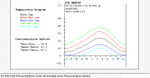
Image:Temperature Parameters 1933-1969 (37 years).jpg|Temperature Parameters 1933-1969 (37 years) | |||
Image:Seasonal Parameters 1933-1969 (37 years).jpg|Parameters 1933-1969 (37 years) | |||
Image:Temperature Diagram 1933-1969 (37 years).jpg|Temperature Diagram 1933-1969 (37 years) | |||
Image:Water Index Card 1933-1969 (37 years).jpg|Water Index Card 1933-1969 (37 years) | |||
Image:Precipitation Parameters 1933-1969 (37 years).jpg|Precipitation Parameters 1933-1969 (37 years) | |||
Image:Climatic Diagram 02 1933-1969 (37 years).jpg|Climatic Diagram 02 1933-1969 (37 years) | |||
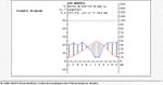
Image:Ombrotermic Diagram 02 1933-1969 (37 years).jpg|Ombrotermic Diagram 02 1933-1969 (37 years) | |||
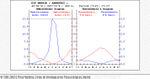
Image:Bioclimatic Index and Diagnosis 1933-1969 (37 years).jpg|Bioclimatic Index and Diagnosis 1933-1969 (37 years) | |||
Image:Bioclimatic Indexes 01 1933-1969 (37 years).jpg|Bioclimatic Indexes 01 1933-1969 (37 years) | |||
Image:Bioclimatic Indexes 02 1933-1969 (37 years).jpg|Bioclimatic Indexes 02 1933-1969 (37 years) | |||
Image:Bioclimatic Parameters 1933-1969 (37 years).jpg|Bioclimatic Parameters 1933-1969 (37 years) | |||
Image:Summary of Rivas Martinez Classification 1933-1969 (37 years).jpg|Summary of Rivas Martinez Classification 1933-1969 (37 years) | |||
</gallery> | |||
=== '''Climatic Data Period 1971 -2000 (Getafe Weather Station)''' === | |||
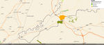
=== Getafe - Aranjuez Location === | |||
[[File:Aranjuez Getafe Location.jpg|400px]] | |||
=== Getafe Climatic Data === | |||
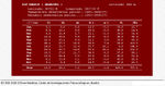
[[File:Climatic Data Getafe.jpg]] | |||
=== Aranjuez Average Climate Data up to 2009 === | |||
[[File:Average Local Data up to 2009.jpg]] | |||
=== Flood Ocurrence === | |||
[[File:Mapa riesgo inundabilidad.jpg|200px|thumb|none|Flood Risk]] | |||
[[File:Laminar_erosion_map.jpg|200px|thumb|none|Laminar_erosion_map]] | |||
[[File:Wind_erosion_map.jpg|200px|thumb|none|Laminar_erosion_map]] | |||
== Analysis of vulnerability == | |||
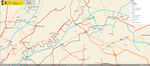
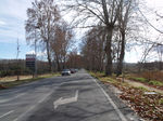
=== Accesses to Aranjuez === | |||
<gallery caption=" " widths="150px" heights="150px" perrow="5"> | |||
Image:North_Puente_Largo_over_Jarama_River.jpg|Puente_Largo_over_Jarama_River | |||
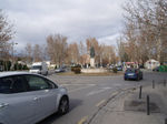
Image:Roundabout adjacent to Puente Largo.jpg|Roundabout adjacent to Puente Largo | |||
Image:Glorieta_de_Santiago_Rusi%C3%B1ol_The_other_side_of_the_Tagus_river.jpg|Glorieta de Santiago Rusiñol The other side of the Tagus river | |||
Image:West_Roundabout_West_access.jpg|West_Roundabout_West_access | |||
Image:Road adjacent to Jardin del Principe 01.jpg|East_Road_adjacent_to_Jardin_del_Principe_01 | |||
Image:Road adjacent to Jardin del Principe 03.jpg|East_Road_adjacent_to_Jardin_del_Principe_02 | |||
Image:Road bridge over Tagus river 02.jpg|Road bridge over the Tagus river | |||
</gallery> | |||
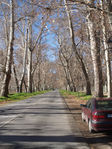
=== Arboriculture management urgently needed === | |||
<gallery caption=" " widths="150px" heights="150px" perrow="5"> | |||
Image:Right_tree_for_the_right_place.jpg|Right_tree_for_the_right_place | |||
Image:Trees_need_enough_room_to_grow_01.jpg|Trees_need_enough_room_to_grow_01 | |||
Image:Trees need enough room to grow 03.jpg|Trees_need_enough_room_to_grow_03 | |||
Image:Trees_need_enough_room_to_grow_05.jpg|Trees_need_enough_room_to_grow_05 | |||
Trees were before this two lane tarmac road.jpg|Trees were before this two lane tarmac road | |||
</gallery> | |||
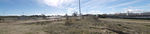
=== Changes are happening right in front of us === | |||
<gallery caption=" " widths="150px" heights="150px" perrow="5"> | |||
Image:Aerial_photo_1946.jpg|Aerial_photo_1946 | |||
Image:Aerial_photo_1956.jpg|Aerial_photo_1956 | |||
Image:Aerial_photo_1975.jpg|Aerial_photo_1975 | |||
Image:Aerial_photo_1991.jpg|Aerial_photo_1991 | |||
Image:Aerial_photo_2006.jpg|Aerial_photo_2006 | |||
Image:Aerial_photo_2011.jpg|Aerial_photo_2011 | |||
Image: Aranjuez gate 1991.jpg|Aranjuez city gate_1991 | |||
Image: Aranjuez gate 2006.jpg|Aranjuez city gate_2006 | |||
Image: Aranjuez gate 2011.jpg|Aranjuez city gate_2011 | |||
Image: Old industrial state ideal for debris_.jpg | |||
</gallery> | |||
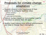
=== Proposals for Climate Change Adaption === | === Proposals for Climate Change Adaption === | ||
* | * Up to the moment the only way of becoming more resilient to climate change is by force, because there are no other options. But really we have changed few ways of doing things not to keep on wasting our resources. Among them it is water management, included in the green areas management. | ||
The way things are going it is taking place a selection process among them, that it will reach the result of keeping the most resistant individuals. | |||
The plant range used has changed a bit but not enough. | |||
The fact that economic activity has reduced its intensity, it has created a reduction in human consumption as a side effect. | |||
* The following measures are ESSENTIAL TO BE TAKEN to help with the resiliency gaining. | |||
* | |||
1.- Educate citizens in the importance of their behavior to configure healthier cities (by mean of urban policies, reglaments and learning enviroments). Unless we manage to help society to make our goals, their goals we won't reach nothing meaningful. | |||
2.- Reduce human impact on monumental trees to help them to extend their life span, reshaping the city council main accesses and main traffic ways. | |||
2.- Improve as much as possible the development conditions for the planted trees and provide as best possible conditions for the new ones. Healthy trees endure more difficult environments and change drastically the urban environments. | |||
=== Image Gallery | The only way to assure sustainability of these measures is achieving citizens compromise for reaching them. Money is not so important, COMPROMISE is FUNDAMENTAL for giving presence to the fourth point of Sustainability. I prefer to consider instead of the Sustainability Triangle, the Sustainability Tetrahedron | ||
[[File:Sustainability tetrahedron 01.jpg|200px|thumb|left|Sustainability Tetrahedron]] | |||
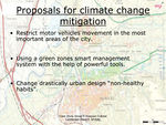
== Proposals for Climate Change Mitigation == | |||
- Restrict motor vehicles movement in the most important areas of the city. With pedestrianitation and "bycyclation" applied to the daily movements we manage to reduce fuel comsuption. | |||
- Using a green zones smart management system with the help of powerful tools e.g. INGRID, we reduce the energy expenditure of the whole system. It cannot be properly considered a side effect but healthy trees increase their C02 fixation rate. | |||
- Change drastically urban design habits in many points e.g.the extensive use of SuDS and porous pavements; the substitution of oil-based tarmac by recicled rubber tarmac, etc. | |||
The way of assuring sustainability for the proposed measures is achieving compromise with citizens. | |||
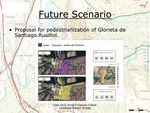
== Your scenario == | |||
=== E.G. Pedestrianization of Glorieta de Santiago Rusiñol=== | |||
<gallery caption=" " widths="150px" heights="150px" perrow="5"> | |||
Image:1.scheme_02.jpg|1.scheme | |||
Image:2.scheme_slides.jpg|2.scheme | |||
Image:3.scheme_03.jpg|3.scheme | |||
Image:4.scheme_04.jpg|4.scheme | |||
</gallery> | |||
== What can be generalized from this case study? == | |||
The Butterfly Effect | |||
Ancient Trees behaviour under Climate Change. | |||
Landscape architects can help meaningfully leading the improvement of urban environment to achieve citizens compromise the inner force that will keep sustainability on track. | |||
== Presentation Slides == | |||
<gallery caption=" " widths="150px" heights="150px" perrow="3"> | |||
Image:Aranjuez Case Study Presentation Slide 1.jpg|Slide One | |||
Image:Aranjuez Case Study Presentation Slide 2.jpg|Slide Two | |||
Image:Aranjuez Case Study Presentation Slide 3.jpg|Slide Three | |||
</gallery> | |||
== Image Gallery == | |||
<gallery caption=" " widths="150px" heights="150px" perrow="5"> | <gallery caption=" " widths="150px" heights="150px" perrow="5"> | ||
| Line 107: | Line 271: | ||
</gallery> | </gallery> | ||
== References == | |||
Please add literature, documentations and weblinks | Please add literature, documentations and weblinks | ||
| Line 114: | Line 277: | ||
[[Category:Climate Change Case Study]] | [[Category:Climate Change Case Study]] | ||
About categories: You can add more categories with this tag: "[[Category:Category Name]]", add your categories | About categories: You can add more categories with this tag: "[[Category:Category Name]]", add your categories | ||
Latest revision as of 02:47, 17 January 2013
| Area | Aranjuez | |||||||||||
| Country | Spain | |||||||||||
| Topic | Effects of climate change and adaptation possibilities - case study from Aranjuez, Spain | |||||||||||
| Author(s) | Eduardo Casado Fernández, Fang Yi, Daniela Staykova | |||||||||||

| ||||||||||||
| {{#widget:GoogleMaps | width=300 | height=200 | lat=40.03219 | lng=-3.602671 | zoom=11 | centermarker=yes | maptypecontrol=yes | overviewmapcontrol=yes | largemapcontrol=yes | scalecontrol=yes
}} | ||
Rationale: Why have you selected this case study area?
- Aranjuez is a town and lying 48 km south of Madrid in the southern part of the autonomous community of the Community of Madrid.
As of 2009, it has a population of 54,055. It is in the Wolrd Heritage List as Cultural Landscape. Climate change is affecting the gardens which are one of the most important elements of the cultural landscape and is affecting the massive trees, mainly specimens of Platanus x hispanica(more than 20-30 m high), and either urban planning is not being helpful either. There are also some other important problems, that should be addressed as soon as possible e.g. the nightmare of the access to the city and its collateral effects.
Authors' perspectives
- As landscape architecs we have an important role to play defining policies (i.e. urban ordinances) designing and applying strategies to improve urban design to preserve the core value of the Cultural Landscape of Aranjuez represented by the historical Gardens of Aranjuez linked to the Royal Palace. Also it is necessary to define policies for landscaping and integrating vegetation regarding other places of the city.
LANDSCAPE AND/OR URBAN CONTEST
-
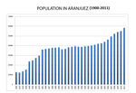 Population in Aranjuez.jpg
 -
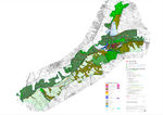 Land Categories in Aranjuez.jpg
 -
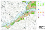 Agrologic classes 1_100000
 -
 Biodiversity species range
 -
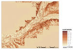 Clinometric model 1_100000
 -
 Shaded topography 1_100000
 -
 Crops
Crops -
 Land Use map 1_100000
 -
 Legend Land Use
 -
 Nature Protected Areas
 -
 Rural tracks
 -
Nature Protected Areas map
-
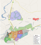 Aranjuez Districts


History
Aranjuez it was the name of an ancient pasture that was understanding, approximately, the lands located among the Tajo and the Sea of Ontígola, of north to south, and the Street of the King and the Bare of the Star, of this to west. In the term of the ancient pasture, were found the village of Aranz, about the gasket of the Tajo rivers and Jarama. From the times of Felipe II, the name of Aranjuez served to designate to the Place, thereinafter Royal Place and, from the reign of Fernando VI, name of the population that here was seated.
The Aranjuez area enjoyed a long history of human settlement before becoming a strategic stronghold during Roman times. Then its position at a river crossing and cross roads - a factor to be repeatedly influential - gave it a significance in the political geography of the time. It lay in a sparsely populated region thereafter and was eventually granted by the Crown to the military order of St James of Santiago in the medieval period. Towards the end of the 14th century, the knights built a palace in the middle of the woods, then replete with game.
Aranjuez became a Royal site in the 15th century, but it was Philip II in the 16th century who created the first period of splendour. He built a new palace and large ornamental and vegetable gardens laid out according to geometric principles, attempting to symbolize his world-wide imperial sovereignty based on a centralized state while at the same time celebrating a return to nature, its structure, and man's supremacy according to the canons of Humanism. It was also a private and personal retreat. Phillip meanwhile pursued botanical experimentation, acclimatizing plant species from all over the world, and introduced hydraulic engineering based on best practice in central Europe and Italy. During the 17th century Aranjuez prospered as the annual abode of royalty, a place of pageantry and hunting, and a source of inspiration for and patronage of some of the greatest Spanish poets of the Golden Age.
The continuing splendour of the 18th century culminated in the building of a new town close to the palace. During the reign of Charles III, the city and its surrounding area became an experimental ground for physiocratic, agricultural, scientific, and social ideas lying at the heart of the Enlightenment. The King sought to provide exemplars both for horticultural practice and in the design of model farms. Such cultural grandeur effectively died when, under external pressure from French Revolutionary ideas and Napoleon's ambitions, the Aranjuez Riot at the end of the century signalled the end of Spain's Ancien Régime.
After a brief revival which added a new element of modernism and eclecticism to the Royal Site during the first half of the 19th century, the end of the reign of Isabella II marked the close of the Crown's exclusive role in the history of this riverside complex and community. A City Council was established independent of Royal command (1836) and the Royal family's use of Aranjuez decreased. At the Revolution in 1868, all Crown property passed to the State and, although large parts of Aranjuez were initially excepted, all that was left in Royal hands by the early 1870s were fragments of their former estate. Meanwhile, the population increased and a railway line (1851) stimulated vigorous economic activity at the price of cutting the Palace's eastern vistas and bisecting the Picotajo garden. During the 20th century Aranjuez became a densely populated satellite city of Madrid, an industrial and cultural centre in which memory and maintenance of the Royal Site deteriorated. Nevertheless, the Site overall kept its integrity, and by the end of that century new assessments, policies, and programmes of works reflected new attitudes of respect for the Royal Site. Source: UNESCO/CLT/WHC
Cultural/social/political context
Cultural Landscape Description
Justification for Inscription as Cultural Landscape (ICOMOS)
Criterion ii : Aranjuez represents the coming together of diverse cultural influences to create a cultural landscape that had a formative influence on further developments in this field.
Criterion iv : The complex designed cultural landscape of Aranjuez, derived from a variety of sources, mark a seminal stage in the development of landscape design.
The complex cultural landscape of Aranjuez, derived from a variety of sources, marks a seminal stage in the development of landscape design. It represents the coming together of diverse cultural influences to create a cultural landscape that had a formative influence on further developments in this field. Aranjuez has been witness to various cultural exchanges over a span of time, in a specific cultural area, that has had a tremendous influence in the development of its landmarks and the creation of its landscape.
Aranjuez represents a model for a given culture's use of its territory. However, the city has become increasingly vulnerable since the disappearance at the turn of the century of the Royal Court that had so much influence on its development. This area enjoyed a long history of human settlement before becoming a strategic stronghold during Roman times, with its position at a river crossing (the Tajo and the Jarama) and cross-roads, to the south of Madrid and to the north-west of Toledo. Towards the end of the 14th century, the knights built a palace in the middle of the woods, then replete with game. But it was Philip II in the 16th century who created the first period of splendour. He built a new palace and large ornamental and vegetable gardens laid out according to geometric principles and it was also a private and personal retreat. During the 17th century Aranjuez prospered as the annual abode of royalty, a place of pageantry and hunting, and a source of inspiration for the patronage of some of the greatest Spanish poets of the Golden Age.
The continuing splendour of the 18th century culminated in the building of a new town close to the palace. After a brief revival which added a new element of modernism and eclecticism to the royal site during the first half of the 19th century, the end of the reign of Isabella II marked the close of the Crown's exclusive role in the history of this riverside complex and community. At the Revolution in 1868, all Crown property passed to the State. By the early 1870s the population increased and a railway line (1851) stimulated vigorous economic activity at the price of cutting the palace's eastern vistas and bisecting the Picotajo garden. During the 20th century, Aranjuez became a densely populated satellite city of Madrid, an industrial and cultural centre. Nevertheless, the site overall kept its integrity. The whole area appears as a green oasis in a landscape otherwise of sierra type, dry, brown and fairly barren of vegetation as a result of climate, geomorphology, and over-exploitive land use.
The site incorporates a planned town, large gardens, vegetable gardens and orchards, lagoons, rivers and waterworks, woods, and moors. The main elements are the Palace and Island Garden, arranged around a plaza with, on the east, the King's Garden of irregular plan with fountains and, on the west, avenues and vistas eventually cut by the railway with, across a canal to the north, entirely within a sharp bend of the river beyond the Garden of the Statues and a fountain, the geometric Island Garden full of fountains and other structures; the Great Historic Garden consisting of a series of gardens which together comprise the bulk of the area; the urban area is subdivided into an industrial area west of the palace, incorporating the railway station and the gardens west of the palace, and the 18th-century town that is now the historic core of modern Aranjuez (the original town plan is intact); and the Prince's Garden, a late 18th- to early 19th-century garden that stretches along the south bank of the Tajo, north-east of the town. These elements are subsumed in a series of intermeshed landscapes, all combining conceptually to create a cultural landscape with rivers, dams, ditches, and fountains. The agricultural landscape is formed by vegetable gardens, orchards, nurseries and stock-breeding; the gardens form a delectable landscape. The geometry, starting with the grand alignments of Phillip II, also influenced parts of the hydraulic system, although clearly other factors were at play there; conversely, the hydrology fed the fountains and ponds, which were usually placed at particular points determined by geometry, albeit serving an aesthetic purpose.
The constructed landscape is formed by roads, architecture, and town. Both the natural and geometric bases of the site as a whole survive remarkably well, with relatively little loss and effectively (modern communication routes apart) no inappropriate intrusion. Major buildings as well as the city's layout and its gardens and tree-lined avenues have been preserved as the characteristic of an urban community among orchards and groves living on a ground plan. Source: UNESCO/CLT/WHC
http://whc.unesco.org/en/list/1044/gallery/
http://turismoenaranjuez.com/aranjuez/jardin-del-principe
LOCAL CLIMATE
Climatic Data Period 1933-1969
-
 Temperature_Data_1933-1969_(37 years)
 -
 Temperature Parameters 1933-1969 (37 years)
 -
 Parameters 1933-1969 (37 years)
 -
 Temperature Diagram 1933-1969 (37 years)
 -
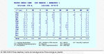 Water Index Card 1933-1969 (37 years)
 -
 Precipitation Parameters 1933-1969 (37 years)
 -
 Climatic Diagram 02 1933-1969 (37 years)
 -
 Ombrotermic Diagram 02 1933-1969 (37 years)
 -
 Bioclimatic Index and Diagnosis 1933-1969 (37 years)
 -
 Bioclimatic Indexes 01 1933-1969 (37 years)
 -
 Bioclimatic Indexes 02 1933-1969 (37 years)
 -
 Bioclimatic Parameters 1933-1969 (37 years)
 -
 Summary of Rivas Martinez Classification 1933-1969 (37 years)
.jpg)
.jpg)
.jpg)
.jpg)
.jpg)
.jpg)
.jpg)
.jpg)
.jpg)
.jpg)
.jpg)
.jpg)
.jpg)
Climatic Data Period 1971 -2000 (Getafe Weather Station)
Getafe - Aranjuez Location

Getafe Climatic Data

Aranjuez Average Climate Data up to 2009

Flood Ocurrence


Analysis of vulnerability
Accesses to Aranjuez
-
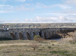 Puente_Largo_over_Jarama_River
 -
 Roundabout adjacent to Puente Largo
 -
 Glorieta de Santiago Rusiñol The other side of the Tagus river
 -
 West_Roundabout_West_access
 -
East_Road_adjacent_to_Jardin_del_Principe_01
-
 East_Road_adjacent_to_Jardin_del_Principe_02
 -
Road bridge over the Tagus river


Arboriculture management urgently needed
-
 Right_tree_for_the_right_place
 -
 Trees_need_enough_room_to_grow_01
 -
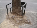 Trees_need_enough_room_to_grow_03
 -
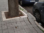 Trees_need_enough_room_to_grow_05
 -
 Trees were before this two lane tarmac road


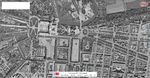
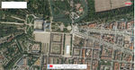
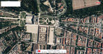
Changes are happening right in front of us
-
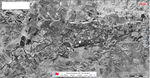 Aerial_photo_1946
 -
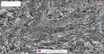 Aerial_photo_1956
 -
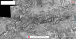 Aerial_photo_1975
 -
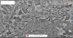 Aerial_photo_1991
 -
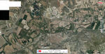 Aerial_photo_2006
 -
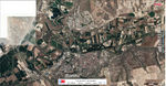 Aerial_photo_2011
 -
 Aranjuez city gate_1991
 -
 Aranjuez city gate_2006
 -
 Aranjuez city gate_2011


Proposals for Climate Change Adaption
- Up to the moment the only way of becoming more resilient to climate change is by force, because there are no other options. But really we have changed few ways of doing things not to keep on wasting our resources. Among them it is water management, included in the green areas management.
The way things are going it is taking place a selection process among them, that it will reach the result of keeping the most resistant individuals.
The plant range used has changed a bit but not enough.
The fact that economic activity has reduced its intensity, it has created a reduction in human consumption as a side effect.
- The following measures are ESSENTIAL TO BE TAKEN to help with the resiliency gaining.
1.- Educate citizens in the importance of their behavior to configure healthier cities (by mean of urban policies, reglaments and learning enviroments). Unless we manage to help society to make our goals, their goals we won't reach nothing meaningful.
2.- Reduce human impact on monumental trees to help them to extend their life span, reshaping the city council main accesses and main traffic ways.
2.- Improve as much as possible the development conditions for the planted trees and provide as best possible conditions for the new ones. Healthy trees endure more difficult environments and change drastically the urban environments.
The only way to assure sustainability of these measures is achieving citizens compromise for reaching them. Money is not so important, COMPROMISE is FUNDAMENTAL for giving presence to the fourth point of Sustainability. I prefer to consider instead of the Sustainability Triangle, the Sustainability Tetrahedron

Proposals for Climate Change Mitigation
- Restrict motor vehicles movement in the most important areas of the city. With pedestrianitation and "bycyclation" applied to the daily movements we manage to reduce fuel comsuption.
- Using a green zones smart management system with the help of powerful tools e.g. INGRID, we reduce the energy expenditure of the whole system. It cannot be properly considered a side effect but healthy trees increase their C02 fixation rate.
- Change drastically urban design habits in many points e.g.the extensive use of SuDS and porous pavements; the substitution of oil-based tarmac by recicled rubber tarmac, etc.
The way of assuring sustainability for the proposed measures is achieving compromise with citizens.
Your scenario
E.G. Pedestrianization of Glorieta de Santiago Rusiñol
-
 1.scheme
 -
 2.scheme
 -
 3.scheme
 -
 4.scheme


What can be generalized from this case study?
The Butterfly Effect
Ancient Trees behaviour under Climate Change.
Landscape architects can help meaningfully leading the improvement of urban environment to achieve citizens compromise the inner force that will keep sustainability on track.
Presentation Slides
-
 Slide One
 -
 Slide Two
 -
 Slide Three


Image Gallery
-
your image text
-
your image text
-
your image text
-
your image text
-
your image text
-
your image text
-
your image text
-
your image text
References
Please add literature, documentations and weblinks
About categories: You can add more categories with this tag: "", add your categories