Belgrano R Train Station: Difference between revisions
No edit summary |
No edit summary |
||
| (3 intermediate revisions by 2 users not shown) | |||
| Line 55: | Line 55: | ||
Image:Belgrano R -Color 1.jpg|Coloured Sketch | Image:Belgrano R -Color 1.jpg|Coloured Sketch | ||
Image:Belgrano R -Color 2.jpg|Coloured Sketch | Image:Belgrano R -Color 2.jpg|Coloured Sketch | ||
Image:Belgrano R-Sketch 2.jpg|Sketch analysis | Image:Belgrano R-Sketch 2.jpg|Sketch analysis. Shows where train station users stand and the paths they use. | ||
</gallery> | </gallery> | ||
| Line 66: | Line 66: | ||
<gallery caption=" " widths="150px" heights="150px" perrow="5"> | <gallery caption=" " widths="150px" heights="150px" perrow="5"> | ||
Image:1-Belgrano R 1876.jpg|First historical layer: The railway and station. | Image:1-Belgrano R 1876.jpg|First historical layer: The railway and station is created. | ||
Image:2-Belgrano R 1880-1910.jpg|Second historical layer: The neighbourhood. | Image:2-Belgrano R 1880-1910.jpg|Second historical layer: The neighbourhood starts to grow as a high class area. | ||
Image:3-Belgrano R 1920-1960.jpg|Third historical layer: | Image:3-Belgrano R 1920-1960.jpg|Third historical layer: The growing continues with a new type consisted by a mid-class area. | ||
Image:4-Belgrano R 1960-Present.jpg|Fourth historical layer: | Image:4-Belgrano R 1960-Present.jpg|Fourth historical layer: In the modern times the mid class area continues to grow, changing houses for buildings. The high class area continues very much the same, with minor changes. | ||
Image:5-Belgrano R Influence.jpg|Station influence area and other nearby stations. | Image:5-Belgrano R Influence.jpg|Station influence area and other nearby stations. This shows the nearby stations and the area in which the Belgrano R Train Station has influence over the general users, assuming that people will use the station is near to their house/workplace and the one they can get the easiest way. | ||
Image:6-Belgrano R Parks.jpg|Nearby parks and its features. | Image:6-Belgrano R Parks.jpg|Nearby parks and its features. It considerate what people can use in the parks. | ||
Image:7-Belgrano R Population.jpg|Neighbourhood's population density. | Image:7-Belgrano R Population.jpg|Neighbourhood's population density. Shows two different areas, as shown in the historical layers: The north side of the railway, formed by high buildings (10 to 20 floors high) which have many people living and therefore increasing the population density (shown as a red area). The south side formed by old big houses with large lots, which decrease the density (shown as a white area) | ||
Image: | Image:9-Belgrano R General Zoom.jpg|First Station zoom: General disposition of the different areas that form the train station. | ||
</gallery> | </gallery> | ||
| Line 88: | Line 89: | ||
''Please publish your findings here'' | ''Please publish your findings here'' | ||
<gallery caption=" " widths="150px" heights="150px" perrow="5"> | <gallery caption=" " widths="150px" heights="150px" perrow="5"> | ||
Image:11-Belgrano R Pedestrian Behaviour.jpg|Pedestrian behaviour: Train station's users path, neighbourhood's paths, places where people usually has to stop, | Image:11-Belgrano R Pedestrian Behaviour.jpg|Pedestrian behaviour: Train station's users path, neighbourhood's paths, places of interest where people goes, places where people usually has to stop (level crossing places, bus stops, train platform, traffic light corners) | ||
Image:10-Belgrano R Behaviour Zoom.jpg|Station zoom: Pedestrian behaviour in the station. Paths that users take to get in or out of the station. | Image:10-Belgrano R Behaviour Zoom.jpg|Station zoom: Pedestrian behaviour in the station. Paths that users take to get in or out of the station. | ||
Image:12-Belgrano R Traffic Behaviour.jpg|Traffic behaviour in the area: Main used streets. The railway level crossing streets available are the only ones that are marked, the others do not work as level crossing for cars. | Image:12-Belgrano R Traffic Behaviour.jpg|Traffic behaviour in the area: Main used streets. The railway level crossing streets available are the only ones that are marked, the others do not work as level crossing for cars. | ||
| Line 100: | Line 101: | ||
* Which measures would be necessary for enhancing the awareness for the area? | * Which measures would be necessary for enhancing the awareness for the area? | ||
* Students are free to choose their method. | * Students are free to choose their method. | ||
-Sidewalk art gallery- | |||
The Belgrano R Train Station behaviour analysis shows that people of the neighbourhood mainly uses the area to go from their homes, working places or other transportation systems, to the station and the way back. So, the neighbourhood’s streets are used mainly to get to the station and out of it. | |||
Knowing this, the project looks for a way to increase awareness of the path people uses, and to make these different paths easy to identify. | |||
To get this showed, the proposal is to create different art galleries on the sidewalks. Each path identified on the behaviour analysis will have different art styles, such as paintings, photography, sculptures, videos and graffities. | |||
A walking-by art gallery will give people something to look at as they get to the station every day and will increase the awareness of the different paths they use and give the chance to follow another path, and so to get to see some other art styles. | |||
Each path will have a unique design so that is easy to identify from the others: One colour each and different stands for the art with different shapes. | |||
<gallery caption=" " widths="150px" heights="150px" perrow="5"> | |||
Image:Belgrano R Train Station 1.jpg|Overall project's paths disposition. | |||
Image:Belgrano R Train Station 2.jpg|Different paths' art stands and characteristics. | |||
Image:Belgrano R Train Station 3.jpg|Example images. | |||
</gallery> | |||
''Please publish your findings here'' | ''Please publish your findings here'' | ||
Latest revision as of 13:44, 10 January 2012
---> back to overview of Case Study List
"Belgrano R" Train Station, Buenos Aires, Argentina
| Name | Belgrano R Train Station | |
| Location | Buenos Aires | |
| Country | Argentina | |
| Authors | Sebastian Sanchez Napal | |

| ||
| <googlemap version="0.9" lat="-34.567857" lon="-58.46279" zoom="16" width="300" height="250">
-34.567804, -58.462619, Belgrano R Train Station Belgrano R Train Station </googlemap> | ||
Short Introduction to the Area of Study
This case study is located in a residential area of Buenos Aires city.
On work days, a huge amount of people use the station: people who live in the neighbourhood and use the train line to go work downtown and people who live in the suburbs and work in commercial areas near the train station.
The train station and the railway, which run east-westwards, divide the urban plot and neighbourhood into two different areas: South side, mainly formed by maximum three-floor houses inhabited and North side, mainly formed by buildings up to 15 floors.
The station is only used as a circulation area and its vacant spaces’ potential are not exploited. It is also surrounded by public parks from which it has small connection with.
It is important for me because I live one block away, walk by the station every day and use the train station every other day.
Exercise 1: Sketching the Landscape
Time frame: October 25 - November 15, 2011
Student activities:
- Creation of analytical drawings and sketches
- Presentation of results
Please upload a selection of your drawings/sketches/mental maps and add them to the image gallery
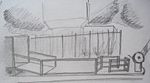
Sketches and Drawings
-
 Sketch
 -
 Sketch
 -
 Sketch
 -
 Sketch
 -
 Coloured Sketch
 -
 Coloured Sketch
 -
 Sketch analysis. Shows where train station users stand and the paths they use.


Exercise 2: Landscape Layers
Time frame: November 15 - 29, 2011
- time based changes and 'landscape biography', and/or:
- topography, open spaces, built, green, traffic and water structures on different layers. *Definition of zones with coherent character
- Description of this character.
-
 First historical layer: The railway and station is created.
 -
 Second historical layer: The neighbourhood starts to grow as a high class area.
 -
 Third historical layer: The growing continues with a new type consisted by a mid-class area.
 -
 Fourth historical layer: In the modern times the mid class area continues to grow, changing houses for buildings. The high class area continues very much the same, with minor changes.
 -
 Station influence area and other nearby stations. This shows the nearby stations and the area in which the Belgrano R Train Station has influence over the general users, assuming that people will use the station is near to their house/workplace and the one they can get the easiest way.
 -
 Nearby parks and its features. It considerate what people can use in the parks.
 -
 Neighbourhood's population density. Shows two different areas, as shown in the historical layers: The north side of the railway, formed by high buildings (10 to 20 floors high) which have many people living and therefore increasing the population density (shown as a red area). The south side formed by old big houses with large lots, which decrease the density (shown as a white area)
 -
 First Station zoom: General disposition of the different areas that form the train station.


Please publish your findings here
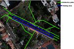
Exercise 3: Behaviour Patterns
Time frame: December 6 - 20, 2011
- How do people behave in this area? How do they use the space? What is important for them?
- Observation of study area, interviews with local people and mapping of use patterns.
- Preparation of short presentation
Please publish your findings here
-
 Pedestrian behaviour: Train station's users path, neighbourhood's paths, places of interest where people goes, places where people usually has to stop (level crossing places, bus stops, train platform, traffic light corners)
 -
 Station zoom: Pedestrian behaviour in the station. Paths that users take to get in or out of the station.
 -
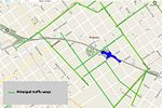 Traffic behaviour in the area: Main used streets. The railway level crossing streets available are the only ones that are marked, the others do not work as level crossing for cars.


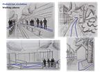
Exercise 4: Communication Concepts
Time frame: December 19, 2011 - January 17, 2012
- Based on the different landscape assessment approaches students will develop a communication concept for their area of study
- Which measures would be necessary for enhancing the awareness for the area?
- Students are free to choose their method.
-Sidewalk art gallery- The Belgrano R Train Station behaviour analysis shows that people of the neighbourhood mainly uses the area to go from their homes, working places or other transportation systems, to the station and the way back. So, the neighbourhood’s streets are used mainly to get to the station and out of it. Knowing this, the project looks for a way to increase awareness of the path people uses, and to make these different paths easy to identify. To get this showed, the proposal is to create different art galleries on the sidewalks. Each path identified on the behaviour analysis will have different art styles, such as paintings, photography, sculptures, videos and graffities. A walking-by art gallery will give people something to look at as they get to the station every day and will increase the awareness of the different paths they use and give the chance to follow another path, and so to get to see some other art styles.
Each path will have a unique design so that is easy to identify from the others: One colour each and different stands for the art with different shapes.
-
 Overall project's paths disposition.
 -
 Different paths' art stands and characteristics.
 -
 Example images.


Please publish your findings here
Image Gallery
-
your image text
-
your image text
-
your image text
-
your image text
-
your image text
References
* Please make sure that you give proper references of all external resources used.
* Do not use images of which you do not hold the copyright.
* Please add internet links to other resources if necessary.
About categories: You can add more categories with this tag: "", add your categories