Luisenplatz: Difference between revisions
No edit summary |
No edit summary |
||
| (19 intermediate revisions by 3 users not shown) | |||
| Line 2: | Line 2: | ||
'''Luisenplatz - Commercial and Transit Central Square''' | '''Luisenplatz - Commercial and Transit Central Square''' | ||
{| align="right" width="300pt" style="background:Gainsboro; color:black" | {| align="right" width="300pt" style="background:Gainsboro; color:black" | ||
| Line 14: | Line 13: | ||
| '''Authors''' || style="background:Lavender"|''Lina Gast, Slavica Cepic'' | | '''Authors''' || style="background:Lavender"|''Lina Gast, Slavica Cepic'' | ||
|- | |- | ||
| colspan="3" align="center" style="background:silver"| [[Image: | | colspan="3" align="center" style="background:silver"| [[Image:Luisenplatz square.jpg|300px]] | ||
|- | |- | ||
| ||style="background:Lavender"| | | ||style="background:Lavender"| | ||
|- | |- | ||
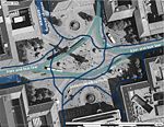
| colspan="3" align="center" style="background:silver"| <googlemap version="0.9" lat=" | | colspan="3" align="center" style="background:silver"| <googlemap version="0.9" lat="49.872789" lon="8.651379" type="satellite" zoom="17" width="300" height="250"> | ||
</googlemap> | <<googlemap version="0.9" lat="49.87282" lon="8.65117" type="satellite" zoom="17"> | ||
49.875832, 8.667526 | |||
</googlemap>> | |||
|} | |} | ||
== Short Introduction to the Area of Study == | == Short Introduction to the Area of Study == | ||
Luisenplatz is a central and most dynamic square in Darmstadt. It is a gravitation point of the city for its central location and the overlap of transit and commercial functions. Luisenplatz is a main public transport change station as many bus and tram lines cross at this square. Pedestrians, cyclists and public transport co-exist at the same place as there is no pavement demarcation between pedestrian paths, bike paths and driveway for the public transport. On the other hand, the square is an “entrance” for the biggest shopping mall in the city and thus attracts many shoppers on a daily base not only from Darmstadt but from the nearby towns as well. It will be interesting to investigate how this place functions, who are the main consumers of the space and how they perceive it. | |||
== Exercise 1: Sketching the Landscape == | == Exercise 1: Sketching the Landscape == | ||
| Line 38: | Line 39: | ||
<gallery caption=" " widths="150px" heights="150px" perrow="5"> | <gallery caption=" " widths="150px" heights="150px" perrow="5"> | ||
Image: | Image:Sketch Luisenplatz 1.jpg|Pedestrians and cyclists at the Luisenplatz | ||
Image: | Image:Sketch Luisenplatz 2.jpg|In front of the Shopping mall | ||
Image:yourimagename.jpg|your image text | Image:yourimagename.jpg|your image text | ||
Image:yourimagename.jpg|your image text | Image:yourimagename.jpg|your image text | ||
| Line 48: | Line 49: | ||
'''Time frame: November 15 - 29, 2011''' | '''Time frame: November 15 - 29, 2011''' | ||
*time based changes and 'landscape biography', and/or: | |||
* topography, open spaces, built, green, traffic and water structures on different layers. *Definition of zones with coherent character | |||
*Description of this character. | |||
<gallery caption=" " widths="150px" heights="150px" perrow="5"> | |||
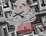
Image:Land Use map.jpg|Land use in the central area of the city: Luisenplatz is embedded in commercial and "institutional" structures | |||
Image:Atmosphere.jpg|Character of the space | |||
Image:3.Circulation map.jpg|Circulation map shows different traffic patterns around Luisenplatz | |||
Image:4.Luisenplatz - Zoning.jpg|Surrounding buildings belong to commercial and governmental structures | |||
Image:5.Luisenplatz-Circulation map.jpg|Circulation map shows different movement patterns at Luisenplatz | |||
Image:Elements at the square.jpg|Elements: land marks and elements of public transport infrastructure | |||
Image:7.Luisenplatz-Green.jpg|Distribution of greenery (trees) | |||
</gallery> | |||
| Line 61: | Line 72: | ||
* Observation of study area, interviews with local people and mapping of use patterns. | * Observation of study area, interviews with local people and mapping of use patterns. | ||
* Preparation of short presentation | * Preparation of short presentation | ||
<gallery caption=" " widths="150px" heights="150px" perrow="5"> | |||
Image:Privatised vs Public space.jpg|Distribution of "privatised" public spaces (gardens of cafes, restaurants) and public benches and "improvised" spaces for rest (stairs, fountain wall) | |||
Image:People.jpg|Spatial distribution of users - 'bipolarisation' of the square | |||
Image:Pedestrian circulation.jpg|Circulation of pedestrians is most intensive around bus&tram stops and shopping area | |||
Image:yourimagename.jpg|your image text | |||
Image:yourimagename.jpg|your image text | |||
</gallery> | |||
''Please publish your findings here'' | ''Please publish your findings here'' | ||
| Line 70: | Line 89: | ||
* Which measures would be necessary for enhancing the awareness for the area? | * Which measures would be necessary for enhancing the awareness for the area? | ||
* Students are free to choose their method. | * Students are free to choose their method. | ||
<gallery caption=" " widths="150px" heights="150px" perrow="5"> | |||
Image:yourimagename.jpg|your image text | |||
Image:yourimagename.jpg|your image text | |||
Image:yourimagename.jpg|your image text | |||
Image:yourimagename.jpg|your image text | |||
Image:yourimagename.jpg|your image text | |||
</gallery> | |||
''Please publish your findings here'' | ''Please publish your findings here'' | ||
| Line 94: | Line 121: | ||
[[Category:Everyday Landscapes Case Study]] | [[Category:Everyday Landscapes Case Study]] | ||
[[Category:Everyday Landscapes Working Group]] | [[Category:Everyday Landscapes Working Group]] | ||
[[Category:Everyday Landscapes Urban Squares]] | |||
About categories: You can add more categories with this tag: "[[Category:Category Name]]", add your categories | About categories: You can add more categories with this tag: "[[Category:Category Name]]", add your categories | ||
Latest revision as of 23:12, 12 December 2011
---> back to overview of Case Study List
Luisenplatz - Commercial and Transit Central Square
| Name | Luisenplatz | |
| Location | Darmstadt | |
| Country | Germany | |
| Authors | Lina Gast, Slavica Cepic | |

| ||
| <googlemap version="0.9" lat="49.872789" lon="8.651379" type="satellite" zoom="17" width="300" height="250">
<<googlemap version="0.9" lat="49.87282" lon="8.65117" type="satellite" zoom="17"> 49.875832, 8.667526 </googlemap>> | ||
Short Introduction to the Area of Study
Luisenplatz is a central and most dynamic square in Darmstadt. It is a gravitation point of the city for its central location and the overlap of transit and commercial functions. Luisenplatz is a main public transport change station as many bus and tram lines cross at this square. Pedestrians, cyclists and public transport co-exist at the same place as there is no pavement demarcation between pedestrian paths, bike paths and driveway for the public transport. On the other hand, the square is an “entrance” for the biggest shopping mall in the city and thus attracts many shoppers on a daily base not only from Darmstadt but from the nearby towns as well. It will be interesting to investigate how this place functions, who are the main consumers of the space and how they perceive it.
Exercise 1: Sketching the Landscape
Time frame: October 25 - November 15, 2011
Student activities:
- Creation of analytical drawings and sketches
- Presentation of results
Please upload a selection of your drawings/sketches/mental maps and add them to the image gallery
Sketches and Drawings
-
 Pedestrians and cyclists at the Luisenplatz
 -
 In front of the Shopping mall
 -
your image text
-
your image text
-
your image text


Exercise 2: Landscape Layers
Time frame: November 15 - 29, 2011
- time based changes and 'landscape biography', and/or:
- topography, open spaces, built, green, traffic and water structures on different layers. *Definition of zones with coherent character
- Description of this character.
-
 Land use in the central area of the city: Luisenplatz is embedded in commercial and "institutional" structures
 -
 Character of the space
 -
 Circulation map shows different traffic patterns around Luisenplatz
 -
 Surrounding buildings belong to commercial and governmental structures
 -
 Circulation map shows different movement patterns at Luisenplatz
 -
 Elements: land marks and elements of public transport infrastructure
 -
 Distribution of greenery (trees)


Please publish your findings here
Exercise 3: Behaviour Patterns
Time frame: December 6 - 20, 2011
- How do people behave in this area? How do they use the space? What is important for them?
- Observation of study area, interviews with local people and mapping of use patterns.
- Preparation of short presentation
-
 Distribution of "privatised" public spaces (gardens of cafes, restaurants) and public benches and "improvised" spaces for rest (stairs, fountain wall)
 -
 Spatial distribution of users - 'bipolarisation' of the square
 -
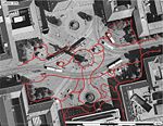 Circulation of pedestrians is most intensive around bus&tram stops and shopping area
 -
your image text
-
your image text


Please publish your findings here
Exercise 4: Communication Concepts
Time frame: December 19, 2011 - January 17, 2012
- Based on the different landscape assessment approaches students will develop a communication concept for their area of study
- Which measures would be necessary for enhancing the awareness for the area?
- Students are free to choose their method.
-
your image text
-
your image text
-
your image text
-
your image text
-
your image text
Please publish your findings here
Image Gallery
-
your image text
-
your image text
-
your image text
-
your image text
-
your image text
References
* Please make sure that you give proper references of all external resources used.
* Do not use images of which you do not hold the copyright.
* Please add internet links to other resources if necessary.
About categories: You can add more categories with this tag: "", add your categories