Case Study Montevideo 1: Difference between revisions
No edit summary |
|||
| (17 intermediate revisions by 3 users not shown) | |||
| Line 5: | Line 5: | ||
{| align="right" width="300pt" style="background:Gainsboro; color:black" | {| align="right" width="300pt" style="background:Gainsboro; color:black" | ||
|- | |- | ||
| '''Name''' | | '''Name''' || style="background:Lavender"| Punta Yeguas Park | ||
|- | |||
| '''Location''' || style="background:Lavender"|Western Montevideo | | '''Location''' || style="background:Lavender"|Western Montevideo | ||
|- | |||
| '''Country''' || style="background:Lavender"|Uruguay | | '''Country''' || style="background:Lavender"|Uruguay | ||
|- | |||
| '''Office''' || style="background:Lavender"|Council of Montevideo and citizens of Western Montevideo | | '''Office''' || style="background:Lavender"|Council of Montevideo and citizens of Western Montevideo | ||
|- | |- | ||
| Line 13: | Line 16: | ||
|- | |- | ||
| '''Completion''' || style="background:Lavender"|In process since 2006 | | '''Completion''' || style="background:Lavender"|In process since 2006 | ||
| colspan="3" align="center" style="background:silver"| [[ | |- | ||
| colspan="3" align="center" style="background:silver"| [[Image:Mapa PYeguas.JPG|300px]] | |||
|- | |- | ||
| ||style="background:Lavender"| | | ||style="background:Lavender"| | ||
|- | |- | ||
| colspan="3" align="center" style="background:silver"| <googlemap version="0.9" lat="- | | colspan="3" align="center" style="background:silver"| <googlemap version="0.9" lat="-34.894238" lon="-56.308537" zoom="13" width="300" height="350"> | ||
</googlemap> | </googlemap> | ||
|} | |} | ||
| Line 28: | Line 32: | ||
Since more than ten years a group of local people is working for protecting this area from devastation. 2006 the Council of Montevideo expropriated this area from private hands to destiny it as a public park and local people work for the design and the managing of the park. | Since more than ten years a group of local people is working for protecting this area from devastation. 2006 the Council of Montevideo expropriated this area from private hands to destiny it as a public park and local people work for the design and the managing of the park. | ||
With the work of local people, who feel indentified with the environment, this project can mean the correct implementation of biological, infrastructural and cultural topics in a territory. A project,which will be easily managed in future, because it is sustained by its own people. | With the work of local people, who feel indentified with the environment, this project can mean the correct implementation of biological, infrastructural and cultural topics in a territory. A project,which will be easily managed in future, because it is sustained by its own people. | ||
'''Comments from kassel university:''' | |||
As a typical case for landscape of the tourist town, Punta Yeguas Park is regarded as the most important and potential project for local development. For these places, building a natural park or national park is a normal way for improving the local landscape development. In Europe, we can also see lots of same examples such as in Italy and Greece. These towns or cities own fantastic coastlines, rich forests and green areas. The protecting the landscape, promoting the tourism, building the comprehensive system, controlling the private hands and improving the environment protection belong to these concepts of landscape development. The Punta Yeguas Park is representative case in South American. Depending on own natural resources is the best way for the future landscape development. | |||
'''Comments from Tartu Group 3:''' | |||
The positive side about the future of the area is that it is maintained by the people living nearby - that gives the area a better maintenance and probably people use it more often, too. Secondly, the different possibilities for people to use it (sporting routes, cultural center etc) make it more attractive and people use the area more. | |||
=== Landscape and/or urban context=== | === Landscape and/or urban context=== | ||
| Line 103: | Line 117: | ||
Comments from kassel university: | '''Comments from kassel university:''' | ||
In this case, landscape is regarded as the important economical benefit | |||
In this case, landscape is regarded as the important economical benefit through the tourism. the project is marked by the natural resources, which combine with the local culture, history, social aspects. The local people also play a main role in promoting the sustainable development. The other important point of this project is the park as a part of eco-region, which is good way for the future landscape. This project shows a good relationship between nature and urbanism. | |||
'''Comments from Tartu Group 3:''' | |||
In this project they have created different possibilities for people to spend their spare time. At the same time, they have promoted general natural resources of the coastline and retained the previously existing landmarks as well as the biological components. | |||
=== You may add 1-2 more core questions as discussed in your group === | === You may add 1-2 more core questions as discussed in your group === | ||
| Line 111: | Line 131: | ||
<gallery caption=" " widths="150px" heights="150px" perrow="5"> | <gallery caption=" " widths="150px" heights="150px" perrow="5"> | ||
Image:Mapa PYeguas. | Image:Mapa PYeguas.JPG|your image text | ||
Image: | Image:StCata1867.jpg|your image text | ||
Image:working for PY.jpg|your image text | Image:working for PY.jpg|your image text | ||
Image:viewPY.jpg|your image text | Image:viewPY.jpg|your image text | ||
Latest revision as of 17:01, 7 December 2010
---> back to overview of Future Landscapes Group 5
Case Study of Punta Yeguas Park on Montevideo Coastline, by Cecilia Curbelo and María Teresa Hampe
| Name | Punta Yeguas Park | |
| Location | Western Montevideo | |
| Country | Uruguay | |
| Office | Council of Montevideo and citizens of Western Montevideo | |
| Client | Citizens of Montevideo | |
| Completion | In process since 2006 | |

| ||
| <googlemap version="0.9" lat="-34.894238" lon="-56.308537" zoom="13" width="300" height="350">
</googlemap> | ||
Core Question 1: In how far does this project reveal your concept of future landscapes?
The Uruguayan economy depends mainly on their natural resources, but in turn it is trying to maintain the objective of Uruguay "Natural Country". The pressure on the natural environment of Montevideo is given by the invasion of different economic activities and by population concentration. A clear example of this situation is its coastline: a great urbanization has taken place in its 22 km, which is making pressure on the more natural western coastland with the invasion of different economical activities. The area of Punta Yeguas Park shows an edge where city and nature meet each another. Since more than ten years a group of local people is working for protecting this area from devastation. 2006 the Council of Montevideo expropriated this area from private hands to destiny it as a public park and local people work for the design and the managing of the park. With the work of local people, who feel indentified with the environment, this project can mean the correct implementation of biological, infrastructural and cultural topics in a territory. A project,which will be easily managed in future, because it is sustained by its own people.
Comments from kassel university:
As a typical case for landscape of the tourist town, Punta Yeguas Park is regarded as the most important and potential project for local development. For these places, building a natural park or national park is a normal way for improving the local landscape development. In Europe, we can also see lots of same examples such as in Italy and Greece. These towns or cities own fantastic coastlines, rich forests and green areas. The protecting the landscape, promoting the tourism, building the comprehensive system, controlling the private hands and improving the environment protection belong to these concepts of landscape development. The Punta Yeguas Park is representative case in South American. Depending on own natural resources is the best way for the future landscape development.
Comments from Tartu Group 3:
The positive side about the future of the area is that it is maintained by the people living nearby - that gives the area a better maintenance and probably people use it more often, too. Secondly, the different possibilities for people to use it (sporting routes, cultural center etc) make it more attractive and people use the area more.
Landscape and/or urban context
- Biogeography, cultural features, overall character, history and dynamics
Illustration: Map; sketches; short descriptive analyses
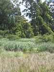
The Punta Yeguas Park is an area of 103 hectares on the coast of the River Plate between the settlement Santa Catalina and the stony border of Punta Yeguas.
The principal landscape feature of this zone is that it looks like a rolling plain with a smooth slope from the route till the coast. On the River Plate are consecutives beaches of dunes of sand, with some prairies and small forests on the top, a some wetland and a stream. The vegetation has different types of forest, indigenous and imported. The vegetation of important size are mostly pines and eucalyptus, both exotic. This park is part of an eco-region with diversity of fish and invertebrates, as well as important mammal and bird colonies.
Cultural/social/political context
- Brief explanation of culture, political economy, legal framework
Illustration: Bullet points, image, background notes
According to the legal framework of the “POT” (Plan de Ordenamiento Territorial de Montevideo), this zone is included as an “Area of Environmental Recover” (Área de Recuperación Ambiental).
This area was in private hands till 2006, exposed to devastation. The owners extracted sand in excess, not taking into account the legal framework that protects the ecosystem in the region. Simultaneously the forest was being destructed because of the commercialization of wood.
People of the environment felt identified with this particular coast side, and felt that is was losing its natural features. The settlements of Western Montevideo are mostly poor and many of them are situated in illegal properties. So they put them self together, but had no economical recourses to manage the situation.
Finally they integrated a representative group of Western Montevideo, so that they could handle and come to an agreement with the Council of Montevideo: In the year 2006, the Council began to expropriate this area from private hands for the destiny of a public park.
Still then and till today they are working for this park trying to achieve their goals.
Spatial analysis of area/project/plan
- What are the main structural features?
- How has it been shaped? Were there any critical decisions?
Illustration: Map/diagram/sketches photos and background notes
As the project aims to promote the general natural features of the western Coastline, the infrastructure proposed for the area has to respect present landmarks and the biological components. It has been shaped to give more value to nature.
Analysis of program/function
- What are the main functional characteristics?
- How have they been expressed or incorporated?
Illustration: Map/diagram/sketches photos and background notes
Goals of the plan(1): - recover a collective space for the city, managed by the neighbors.
- integrate recreational and cultural activities with the natural features of the coast, the sighting of birds
- create social responsibility on the use of space, its flora and fauna.
The planning is based in a zoning of the different activities: camping, sports, a cultural center with the possibility for a museum, a multi center, an information center. The necessary infrastructures imply paths for walking, jogging and cycling, lighting, signaling the services offered in the area, and the identification of the different vegetation, among others.
(1)Seminario Taller Parque Público Punta Yeguas, 2007
Analysis of design/planning process
- How was the area/project/plan formulated and implemented?
- Were there any important consultations/collaborations?
Illustration: Map/diagram/sketches photos and background notes
The design process is the result of the dynamic teamwork of the people of the neighborhood, with the collaboration of professional of the council and other volunteers. The planning method used was “Participatory planning for scenarios formalized with planning management” by the project PPGA (Planificación Participativa y Gestión Asociada) from FLACSO (Facultad Latinoamericana de Ciencias Sociales).
But the focus of the problem is just the area of Punta Yeguas. It is necessary to overview the connection with the rest of western coastline to have a harmonious interrelationship with other structural elements of the territory.
Analysis of use/users
- How is the area/project/plan used and by whom?
- Is the use changing? Are there any issues?
Illustration: Map/diagram/sketches photos and background notes
The area is used mainly by the local population, but in the summer people arrive from all Montevideo. The different offers of sports, the recreation possibilities and the natural sight, makes the place very attractive.
Core Question 2: What is the role of landscape architecture in this project?
A territory suffers the tensions of different agents: The future landscape depends of the regards of local people and what they expect for their landscape, the benefits of the government and global economical interests. The results of this pressure will have different consequences, which have to be considered by a landscape planner. According to Thomas Sieverts (1997) “the protection of nature is essential in order to retain the “historical” nature as an object of living experience in the city”. In this project a landscape planner has an ethical debt to support and promote local people who are working hard for managing their natural environment. But as a part of an eco-region an integrated design of this park to the rest of the coast and the rural district is necessary and possibilities a continuum with the rest of the coast. This makes possible different lectures (esthetic, cultural, economical) of Montevideo’s coastline, with a gradual transformation from urban to rural and natural backgrounds. The combination of the professional vision of landscape planner with the aspirations of social groups, the knowledge of the legal framework and the ecological conditions of the coast are the clues to find the necessary links between nature and urbanism.
Comments from kassel university:
In this case, landscape is regarded as the important economical benefit through the tourism. the project is marked by the natural resources, which combine with the local culture, history, social aspects. The local people also play a main role in promoting the sustainable development. The other important point of this project is the park as a part of eco-region, which is good way for the future landscape. This project shows a good relationship between nature and urbanism.
Comments from Tartu Group 3:
In this project they have created different possibilities for people to spend their spare time. At the same time, they have promoted general natural resources of the coastline and retained the previously existing landmarks as well as the biological components.
You may add 1-2 more core questions as discussed in your group
Image Gallery
-
 your image text
 -
 your image text
 -
 your image text
 -
 your image text
 -
 your image text


Punta Yeguas Park
References
Please add literature, documentations and weblinks
o DINAMA (2008) “Uruguay and the convention on Biological Diversity: Advances and challenges”, edited by the Ministery of Housing, Territorial Planning and Environment, Montevideo
o Seminario Taller de planificación Participativa Junta Departamental Montevideo, 2007 “Diseñando juntos el Parque Público Punta Yeguas”, edited by Gráfica Don Bosco, Montevideo
o Sieverts, Thomas (1997) “Cities without cities. An interpretation of the Zwischenstadt” edited in English 2003 by Spon Spress, London
About categories: You can add more categories with this tag: "", add your categories