Pictures of our Landscapes BIOS Group 3: Difference between revisions
No edit summary |
|||
| (2 intermediate revisions by the same user not shown) | |||
| Line 5: | Line 5: | ||
=== Images === | === Images === | ||
<gallery caption=" " widths="200px" heights="150px" perrow="3"> | <gallery caption=" " widths="200px" heights="150px" perrow="3"> | ||
Image: | Image:Montevideo_bay & hill.jpg|Montevideo_the bay & the hill | ||
Image: | Image:Montevideo_Italia Av.jpg|Montevideo_Italia avenue | ||
Image: | Image:Montevideo_Blanes street.jpg|Montevideo_Blanes street | ||
</gallery> | </gallery> | ||
=== Description === | === Description === | ||
== '''Montevideo: three images, three landscape scales''' == | |||
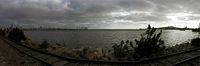
'''Image#1_ Hill, bay and harbor''' | |||
Montevideo owes its name to a geographical singularity (that is, a hill next to a bay) and to its cartographic registration. According to some theories, this name comes from annotations on navegation charts in which the enclave was identified as “MONTE VI d/ E-O”, wich would mean the sixth Hill in East-West direction. The bay offered perfect conditions for a port. The peninsula that closed it was perfect to set a defensive structure up there. Montevideo was founded in 1725 by military-strategic reasons in the context of territorial and trade disputes between the Spanish and Portuguese kingdoms. | |||
The port of Montevideo has been since its begining one of the city drivers. It made possible the entrance and exit of goods. But it also has been a place steeped in nostalgia. Immigrant and visitor`s first city images were that of the port. Montevideo has been a peripheral, quiet and provincial city. | |||
Montevideo bay, with its obsolete and abandoned naval installations has created a "junk backyard" atmosphere in some sections. | |||
Despite this, the development of the port and all its logistical, which is of strategic and economic importance to the city and to Uruguay, are changing this. This has produced domain conflicts, access and visual restrictions on important sections of the bay. | |||
Montevideo is closely linked to the coastline and to the "sea." But what we call "sea" is actually a very wide estuary (estuary of the Rio de la Plata) that inhabitants of Montevideo don`t recognize. | |||
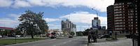
'''Image#2_Italia Av.''' | |||
Montevideo's landscape is defined by gently undulating relief with slopes towards the sea. This cause that numerous small streams cross the underground. | |||
Montevideo has low air pollution rates and a good proportion of green areas that include squares, various parks such as Parque Batlle and green stripes along avenues such as in Italia Av. | |||
The growing vehicular traffic begins to exert pressure causing problems in road infrastructure. Its posible solution compromise some green areas (the central stripe of Italia Av. for example, to build a highway that would connect the airport to downtown). | |||
On the other hand, there is a growing visual pollution as a result of how individuals, organizations, institutions and companies operate in the urban area, ie giving priority to their individual needs above the common interest. This has generated an accumulation of individual and uncoordinated interventions (urban tree selection by municipal technicians, installation of telephone booths, security guard booths, overhead wires, radio and TV antennas). | |||
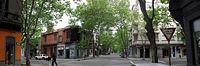
'''Image#3_Blanes street''' is representative of a part of the city built between the late XIX century and the first half of the twentieth century. Different low rise architectures coexist here, influenced by Spanish, French, Art Deco and modern rationalism types. | |||
The juxtaposition of architectures as well as the use of color on the front of these buildings (facades) create a picturesque landscape due to the accumulation of individual or individualistic actions . The front of these buildings on the other hand express a conflict between public and private domains, between the common good and the individual rights. | |||
Urban trees (Platanus hybrida in this case) form a “green vault” on the streets that are another key feature of Montevideo´s landscape. You may recognize in this image bits of other cities. | |||
[[Category:Pictures of our Landscapes]] | [[Category:Pictures of our Landscapes]] | ||
Latest revision as of 01:31, 26 October 2010
---> Back to overview of groups
Rita Soria+Keiko+Beatriz Diaz+Pilar Ramos+Alejandro Recoba
Images
-
 Montevideo_the bay & the hill
 -
 Montevideo_Italia avenue
 -
 Montevideo_Blanes street


Description
Montevideo: three images, three landscape scales
Image#1_ Hill, bay and harbor Montevideo owes its name to a geographical singularity (that is, a hill next to a bay) and to its cartographic registration. According to some theories, this name comes from annotations on navegation charts in which the enclave was identified as “MONTE VI d/ E-O”, wich would mean the sixth Hill in East-West direction. The bay offered perfect conditions for a port. The peninsula that closed it was perfect to set a defensive structure up there. Montevideo was founded in 1725 by military-strategic reasons in the context of territorial and trade disputes between the Spanish and Portuguese kingdoms.
The port of Montevideo has been since its begining one of the city drivers. It made possible the entrance and exit of goods. But it also has been a place steeped in nostalgia. Immigrant and visitor`s first city images were that of the port. Montevideo has been a peripheral, quiet and provincial city. Montevideo bay, with its obsolete and abandoned naval installations has created a "junk backyard" atmosphere in some sections. Despite this, the development of the port and all its logistical, which is of strategic and economic importance to the city and to Uruguay, are changing this. This has produced domain conflicts, access and visual restrictions on important sections of the bay. Montevideo is closely linked to the coastline and to the "sea." But what we call "sea" is actually a very wide estuary (estuary of the Rio de la Plata) that inhabitants of Montevideo don`t recognize.
Image#2_Italia Av. Montevideo's landscape is defined by gently undulating relief with slopes towards the sea. This cause that numerous small streams cross the underground. Montevideo has low air pollution rates and a good proportion of green areas that include squares, various parks such as Parque Batlle and green stripes along avenues such as in Italia Av.
The growing vehicular traffic begins to exert pressure causing problems in road infrastructure. Its posible solution compromise some green areas (the central stripe of Italia Av. for example, to build a highway that would connect the airport to downtown). On the other hand, there is a growing visual pollution as a result of how individuals, organizations, institutions and companies operate in the urban area, ie giving priority to their individual needs above the common interest. This has generated an accumulation of individual and uncoordinated interventions (urban tree selection by municipal technicians, installation of telephone booths, security guard booths, overhead wires, radio and TV antennas).
Image#3_Blanes street is representative of a part of the city built between the late XIX century and the first half of the twentieth century. Different low rise architectures coexist here, influenced by Spanish, French, Art Deco and modern rationalism types. The juxtaposition of architectures as well as the use of color on the front of these buildings (facades) create a picturesque landscape due to the accumulation of individual or individualistic actions . The front of these buildings on the other hand express a conflict between public and private domains, between the common good and the individual rights. Urban trees (Platanus hybrida in this case) form a “green vault” on the streets that are another key feature of Montevideo´s landscape. You may recognize in this image bits of other cities.