Collaborative Green Infrastructure Design Group J: Difference between revisions
| Line 43: | Line 43: | ||
<gallery caption="Analytical Drawings " widths="150px" heights="150px" perrow="4"> | <gallery caption="Analytical Drawings " widths="150px" heights="150px" perrow="4"> | ||
Image:yourfilename1.jpg|analytical drawing 1 | Image:yourfilename1.jpg|analytical drawing 1 | ||
Image: | Image:Valencia_map_analysis.jpg|Analysis map | ||
Image:yourfilename3.jpg|analytical drawing 3 | Image:yourfilename3.jpg|analytical drawing 3 | ||
Image:yourfilename4.jpg|analytical drawing 4 | Image:yourfilename4.jpg|analytical drawing 4 | ||
Revision as of 17:52, 27 January 2015
---> back to group page working group J
Please add the title of your case study here, adjust the map coordinates and replace the moa image with a characteristic image of your site
| Name | add name | |
| Location | add location | |
| Country | add country | |
| Authors | add author | |

| ||
|
| ||
The Ensanche neighborhood (L'Eixample) was the first urban enlargement after the Valencian city wall demolition. As most mediterranean cities in the early XIX Century, Valencia also followed the Plan designed by Ing. Mr. Cerdá for the urban enlargement of Barcelona. Unfortunately, the most important ideas of the original Plan were forgotten. The open blocks were built completely closed, preventing people to walk through the green areas that Mr. Cerdá designed for the interior area of the blocks. Even more, these green areas were finally occupied by stores, ware houses and car parks. Furthermore, the original storey number was also increased. The final result is a neighborhood without green spaces or public squares and absolutely waterproof. We must take in account that we are speaking about a big and dry mediterranean city with more than 3.000 sun hours per year but with storm rain episodes that collapses immediately the runoff water management system. All rain water is lost in a place were every drop is needed for life. Why this case is interesting? Because we have a dry, hot, waterproof, polluted and inefficient neighborhood that is asking a better functionality; in other words, new green infrastructures.
What are the overall objectives of your design? What are the specific objectives for enhancing green infrastrucutre?
Improve water management - Green roofs - sustainable drainage system - more pedestrian space instead roads and car space - more trees - bike lines - calming traffic measures - permeable - pavements - permeable roads - run off storage underground system - etc
Analytical drawings
Please add four analytical sketches/drawings (or montages/schemes) of your case. Every group member needs to contribute at least one drawing.
- Analytical Drawings
- Yourfilename1.jpg
analytical drawing 1
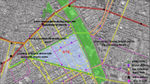
Analysis map
- Yourfilename3.jpg
analytical drawing 3
- Yourfilename4.jpg
analytical drawing 4

Projective drawings
Please add four projective sketches/drawings (or montages/schemes), of course with an emphasis on green infrastructure aspects. Every group member needs to contribute at least one drawing representing his/her individual ideas.
- Projective Drawings
- Yourfilename1.jpg
projective drawing 1
- Yourfilename2.jpg
projective drawing 2
- Yourfilename3.jpg
projective drawing 3
- Yourfilename4.jpg
projective drawing 4
Design Synthesis
Please analyse the individual approaches presented so far and evaluate their strengths and weaknesses (you may use the SWOTanalysis model). Try to create a synthesis and represent it with a plan and some sketches. You can still use drawings/sketches.
- Design Synthesis Drawings
- Yourfilename1.jpg
synthesis drawing 1
- Yourfilename2.jpg
synthesis drawing 2
- Yourfilename3.jpg
synthesis drawing 3
- Yourfilename4.jpg
synthesis drawing 4
Summary of the collaborative process
Please reflect on your collaborative design process. Which potentials have you encountered? What was most difficult? What does collaborative design mean for you? (approx 150 words).
Image Gallery
You may add a series of images/photos in addition to the sketches/drawings
- Image Gallery
- Yourfilename1.jpg
image 1
- Yourfilename2.jpg
image 2
- Yourfilename3.jpg
image 3
- Yourfilename4.jpg
image 4
References
* Please make sure that you give proper references of all external resources used.
* Do not use images of which you do not hold the copyright.
* Please add internet links to other resources if necessary.
About categories: You can add more categories with this tag: "", add your categories