Collaborative Green Infrastructure Design Group N: Difference between revisions
Boschirolib (talk | contribs) |
Boschirolib (talk | contribs) |
||
| Line 49: | Line 49: | ||
<gallery caption= "Illustrations" widths="150px" heights="150px" perrow="3"> | <gallery caption= "Illustrations" widths="150px" heights="150px" perrow="3"> | ||
Image:1_inquadramento.jpg|1_The big scale | Image:1_inquadramento.jpg|1_The big scale | ||
Image:2_Rete-ecologica_low.jpg|2_The ecological network | Image:2_Rete-ecologica_low.jpg|2_The ecological network | ||
Image:3_River and dead branch.jpg|3_The river and the dead branches of the river | Image:3_River and dead branch.jpg|3_The river and the dead branches of the river | ||
</gallery> | |||
== What are the overall objectives of your design? What are the specific objectives for enhancing green infrastrucutre? == | == What are the overall objectives of your design? What are the specific objectives for enhancing green infrastrucutre? == | ||
Revision as of 08:59, 7 January 2015
---> back to group page working group N
Bastia farms, Cavenago d'Adda, Lodi, Italy
| Name | Bastia farms | |
| Location | Cavenago d'Adda, Lodi | |
| Country | Italy | |
| Authors | Group N | |

| ||
|
| ||
Landscape and/or urban context of your case
- Biogeography, cultural features, overall character, history and dynamics
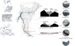
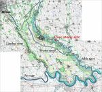
The Adda river is one of the main tributary to the Po, the main river in the north of Italy.
The Adda borns in the Alps and crosses all the Lombardia region, passing through the Lecco lake, arrives in the flat area of the Pianura Padana. The Adda river is protected by two regional parks: the North, between the lake and Lodi town, and the South one, from Lodi town to the Po river. The two parks differ for the context the river crosses by and for the river course's features.
The case study belongs to the South park area, where the course of the river becomes wider and with a lot of meanders, due to its lower speed across the plain( pic. 1). This part of the plain is dominated by the Adda and the Lambro river courses and by numerous canals for irrigation. The ecologic structure is based on the water courses and on their vegetation areas. (pic.2) The South park is characterized by a series of dead river branches, beside the meanders; one of the most famous is the Soltarico branch, originated from the flood in the 1976 when the river skipped the Soltarico meander and originated 7 km of a series of wetlands and islands. Beside the Soltarico reserve there are other 5 natural reserve dead branches (pic.3). These protected areas (Life EU network) are important for their flora and fauna habitats, rare in the plain around.
Even though the importance of these reserves, the Adda South Park has not many touristic structures: there isn’t a continuous path networks on the banks, there aren’t refreshment areas or other structures that could improve the recreation adn leisure.
The case study is placed in one dead river branch and is the only one not transformed in a protected area.
The Pianura Padana region is defined by its highly developed and mechanized agriculture. The landscape is dominated by the rhythm of the rural productions, corn and forage for the milk cows, and by the presence of small towns, villages and isolated farms, some of them quite old. Each of these towns and villages has its own church and bell tower, so even when the corn reaches its maximum height, in the end of summer, you can easily orientate yourself looking for the nearest tower or church.
- Illustrations
1_The big scale
2_The ecological network
3_The river and the dead branches of the river


What are the overall objectives of your design? What are the specific objectives for enhancing green infrastrucutre?
Please give a short written argumentation (not more than 150 words). It is ok if you have different or even contradicting objectives within your group. Just make it explicit at the beginning of your process
Analytical drawings
Please add four analytical sketches/drawings (or montages/schemes) of your case. Every group member needs to contribute at least one drawing.
- Analytical Drawings
- Yourfilename1.jpg
analytical drawing 1
- Yourfilename2.jpg
analytical drawing 2
- Yourfilename3.jpg
analytical drawing 3
- Yourfilename4.jpg
analytical drawing 4
Projective drawings
Please add four projective sketches/drawings (or montages/schemes), of course with an emphasis on green infrastructure aspects. Every group member needs to contribute at least one drawing representing his/her individual ideas.
- Projective Drawings
- Yourfilename1.jpg
projective drawing 1
- Yourfilename2.jpg
projective drawing 2
- Yourfilename3.jpg
projective drawing 3
- Yourfilename4.jpg
projective drawing 4
Design Synthesis
Please analyse the individual approaches presented so far and evaluate their strengths and weaknesses (you may use the SWOTanalysis model). Try to create a synthesis and represent it with a plan and some sketches. You can still use drawings/sketches.
- Design Synthesis Drawings
- Yourfilename1.jpg
synthesis drawing 1
- Yourfilename2.jpg
synthesis drawing 2
- Yourfilename3.jpg
synthesis drawing 3
- Yourfilename4.jpg
synthesis drawing 4
Summary of the collaborative process
Please reflect on your collaborative design process. Which potentials have you encountered? What was most difficult? What does collaborative design mean for you? (approx 150 words).
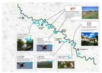
Image Gallery
You may add a series of images/photos in addition to the sketches/drawings
- Image Gallery
- Yourfilename1.jpg
image 1
- Yourfilename2.jpg
image 2
- Yourfilename3.jpg
image 3
- Yourfilename4.jpg
image 4
References
* Please make sure that you give proper references of all external resources used.
* Do not use images of which you do not hold the copyright.
* Please add internet links to other resources if necessary.
About categories: You can add more categories with this tag: "", add your categories