Green Infrastructure 2014 Group K - Case Study 3: Difference between revisions
| (17 intermediate revisions by the same user not shown) | |||
| Line 91: | Line 91: | ||
*'''''History & Dynamics from the Early Bronze Age till the 1950s''' | *'''''History & Dynamics from the Early Bronze Age till the 1950s''' | ||
The first signs of settlement date back to the Early Bronze Age and later to the Early and Late Roman Period. The famous ''Limes Romanus'' stretched about 2-3 km south of the settlement. | The first signs of settlement date back to the Early Bronze Age and later to the Early and Late Roman Period. The famous ''Limes Romanus'' stretched about 2-3 km south of the settlement. After approximately 2 centuries of Slavonic settlement, the first Hungarian settlement is dated back to 970-1020, approximately a century after the arrival of Hungarian settlers to the ''Danube Lowland'', due to the '''marshy character of the landscape'''. This swampy land was a kind of protective space for the inhabitants throughout the centuries till the Middle Ages. | ||
The first written report dates back to 1221 | The first written report dates back to 1221. The settlement laid on an important medieval road from Budapest to Bohemia and Poland. The Tatars bypassed the village in 1241 because of the swampy ground. | ||
In 1332 King ''Károly I.'' mentions the settlement under the name ''Turdesqed''. In the 14th century the original church was built as a Romanesque chapel, later rebuilt with some elements of the Early Gothic. The settlement was intensively developing in the 14th century and is mentioned as '' | In 1332 King ''Károly I.'' mentions the settlement under the name ''Turdesqed''. In the 14th century the original church was built as a Romanesque chapel, later rebuilt with some elements of the Early Gothic. The settlement was intensively developing in the 13th and 14th century and is mentioned as ''Tardoskedde'', ''Turdaskeddi'', ''Turdesqued'', ''Tardos Kegy'' and other variations (stabilized in the late 19th century to ''Tardoskedd''). | ||
In the 16th century, the settlement is already mentioned as a '''developed central village'''. It is mentioned among the richest villages of the region. During the Turkish incursions, the inhabitants fled to the marshland called ''Faluhely'' in the surrounding landscape for almost 100 years. | In the 16th century, the settlement is already mentioned as a '''developed central village'''. It is mentioned among the richest villages of the region. During the Turkish incursions, the inhabitants fled to the marshland called ''Faluhely'' in the surrounding landscape for almost 100 years. | ||
| Line 101: | Line 101: | ||
Emperor ''Ferdinánd III.'' confers the right of '''small town''' "Mezőváros" (Lat. '''Oppidum''', Eng. '''Market Town''' - ruled by a squire; which had the right to organize markets, but did not have the right to build a fortification or town wall, only paling was allowed - Author´s Note). In the second half of the 17th century, Turkish troops plundered the settlement. The inhabitants hid again in the '''marshlands which surrounded the town'''. In the tax register from 1664, the town is referred to as personal property of a Turkish Pasha. The ''Nové Zámky Fortress'' (near Tardoskedd) was conquered (reclaimed) in 1685 by the imperial chieftain ''Charles of Lorraine''. | Emperor ''Ferdinánd III.'' confers the right of '''small town''' "Mezőváros" (Lat. '''Oppidum''', Eng. '''Market Town''' - ruled by a squire; which had the right to organize markets, but did not have the right to build a fortification or town wall, only paling was allowed - Author´s Note). In the second half of the 17th century, Turkish troops plundered the settlement. The inhabitants hid again in the '''marshlands which surrounded the town'''. In the tax register from 1664, the town is referred to as personal property of a Turkish Pasha. The ''Nové Zámky Fortress'' (near Tardoskedd) was conquered (reclaimed) in 1685 by the imperial chieftain ''Charles of Lorraine''. | ||
In the 18th century, the development of the settlement was marked by the Rákóczi Uprising (Rákóczi conquered the Nové Zámky Fortress in 1704). After this, the settlement becomes a big military camp with a military postal system. | In the 18th century, the development of the settlement was marked by the Rákóczi Uprising (Rákóczi conquered the Nové Zámky Fortress in 1704). After this, the settlement becomes a big military camp with a military postal system. Based on a local legend/tradition, there was a battle between the Kuruc army (rebels against the Habsburgs - Author´s note) and the imperial army at the so called ''Rákóczi Hill'' (located in the present cemetery and marked with a historic monument - Author´s note), where hundreds of imperial (Habsburg) soldiers were conquered. In memory of winning the battle, a monument was built on the mentioned hill. | ||
The church was vastly rebuilt in the period between 1707 and 1725 (into the present Baroque style - Author´s note); in 1753 a Calvary was built at the church. Under the reign of Maria Theresia (1740-1780), Tardoskedd became an important '''town''' on the royal road from Vienna to Buda '''with the right to organize markets'''. There were famous regional cattle fairs, possibility of horse re-harness and a large royal hotel near the town, in Csike, where even Maria Theresa stayed overnight several times. According to the census from 1779, the town had 2288 inhabitants. | The church was vastly rebuilt in the period between 1707 and 1725 (into the present Baroque style - Author´s note); in 1753 a Calvary was built at the church. Under the reign of Maria Theresia (1740-1780), Tardoskedd became an important '''town''' on the royal road from Vienna to Buda '''with the right to organize markets'''. There were famous regional cattle fairs, possibility of horse re-harness and a large royal hotel near the town, in Csike, where even Maria Theresa stayed overnight several times. According to the census from 1779, the town had 2288 inhabitants. | ||
| Line 107: | Line 107: | ||
After the revolution (1848-1849) the building of the '''railway from Budapest to Vienna''' through Marchegg was finished and opened in 1850. The first permanent post office was established in 1868. | After the revolution (1848-1849) the building of the '''railway from Budapest to Vienna''' through Marchegg was finished and opened in 1850. The first permanent post office was established in 1868. | ||
After World War II., many '''privately owned properties were confiscated in 1948/1949''' - | After World War II., many '''privately owned properties were confiscated in 1948/1949''' - all shops and inns were expropriated and managed by Jednota (consumer cooperative "Unity" - Author´s Note). In February 1950, the Unified Cooperative Farm was established, in order to manage the collectivisation of agriculture in the town. Besides expropriation of privately owned establishments and collectivisation of agricultural land, the town was markedly influenced by eviction and deportation of inhabitants. In 1948-1954, a sports complex was established in the garden of the wealthy Juhász Family Farmyard. Next to the stadium a swimming pool was built in 1955-1957. | ||
(Tvrdošovce Municipality 2014; Tóth 2012-2014) | (Tvrdošovce Municipality 2014; Tóth 2012-2014) | ||
| Line 173: | Line 173: | ||
== Image Gallery == | == Image Gallery == | ||
'' | ''Exploring the Features of the Landscape within and around Tvrdošovce'' | ||
<gallery caption="Image Gallery" widths="150px" heights="150px" perrow="4"> | <gallery caption="Image Gallery" widths="150px" heights="150px" perrow="4"> | ||
Image: | Image:LandscapeContext.jpeg|Regional Identity | ||
Image: | Image:LandscapeContext2.jpeg|Landscape Context | ||
Image: | Image:SettlementLandscapeImage.jpg|Settlement & Landscape Image | ||
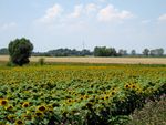
Image: | Image:AgriculturalLandscapes.jpg|Agricultural Landscapes | ||
Image: | Image:WaterLandscape.jpg|Water in the Landscape | ||
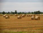
Image: | Image:AgricultureLegacy.jpeg|Agricultural Legacy | ||
Image: | Image:ArchLandmark.jpg|Architectural Landmark | ||
Image: | Image:Wildlife.jpg|Wildlife | ||
</gallery> | </gallery> | ||
== References == | == References == | ||
BUDA, František. 2009. ''Tvrdošovce-Tardoskedd: Kapitoly o minulosti, súčasnosti, obyvateľstve a zaujímavostiach Tvrdošoviec''. Komárno: Print-K, 2009, 334 s., ISBN 978-80-970181-9-1. | |||
TÓTH, Attila - FERIANCOVÁ, Ľubica. 2013. Green Infrastructure in the Context of Rural Space Restoration and Design. In: Nordic Journal of Architectural Research. Vol. 25, No. 2. pp. 187-212. ISSN 1893-5281. | |||
TÓTH, Attila. 2013. Green Infrastructure: Planning and Design of Rural Landscapes - Case Study: Cergát-Váh, Tvrdošovce. In: Kubišta, R. (eds.): Trendy v krajinotvorbe [Trends in Landscape Design]. Nitra: Slovak University of Agriculture, 2013, pp.52-59. 59 p. ISBN 978-80-552-1033-9. | |||
TÓTH, Attila. 2013. Green Infrastructure Planning for Sustainable Rural Development. In: Neményi, M. et al. (eds.): Science for Sustainability: International Scientific Conference for PhD Students: Proceedings, University of West Hungary, Győr, March 19-20, 2013. Sopron: University of West Hungary Press, 2013, pp. 392-397. 414 p. ISBN 978-963-334-103-2. | |||
TÓTH, Attila. 2013. Current challenges in rural development in terms of landscape planning and landscape architecture: Case study of Tvrdošovce, Slovakia / A vidékfejlesztés aktuális tájtervezési és tájépítészeti kihívásai: Esettanulmány - Tardoskedd, Szlovákia. In: Talentum - Hensch Árpád nyomdokain: A Gazdálkodásban publikált PhD hallgatók és kutatók III. országos tudományos konferenciája [CD]. Mosonmagyaróvár : University of West-Hungary, 2013, pp. 1-6. 178 p. ISBN 978-963-334-108-7 (CD with full papers), ISBN 978-963-334-107-0 (printed proceeding of abstracts, p. 62). | |||
TÓTH, Attila - SUPUKA, Ján. 2014. Greenways: A Landscape Planning Tool for Restoration of Linkages in the Landscape. In: Berichte des Instituts Verkehr und Raum: How to push the implementation of the European Green Belt by landscape policy instruments? Erfurt: Fachhochschule, Vol. 18, No. 1. pp. 93-103. ISSN 1868-8586. | |||
TÓTH, Attila. 2013. Rural Landscape Transformations by the Example of the Village Tvrdošovce in Slovakia. In: Stará, Kristýna (Eds.): Landscape Transformations of the Post-Communist Countries. Prague: Czech Technical University, 2013, pp.54-59. 200 p. ISBN 978-80-01-05431-4. | |||
TÓTH, Attila - FERIANCOVÁ, Ľubica. 2013. The Role of Landscape Architecture in Rural Development. In: Škarpa, P. et al. (Eds.): MendelNet 2013 - Proceedings of International PhD Students Conference. Brno: Mendel University, 2013, pp.516-520. 955 p. ISBN 978-80-7375-908-7. | |||
TÓTH, Attila - FERIANCOVÁ, Ľubica. 2014. By Improvement of the Green Infrastructure towards Sustainable Landscapes and Resilient Environments. In: G20 Youth Forum 2014 Conference Proceedings, Garmisch-Partenkirchen, Germany. Genève: G8&G20 Alumni Association, 2014, pp.405-410. 695 p. ISSN 2297-0134. | |||
TÓTH, Attila - BIHUŇOVÁ, Mária - HALAJOVÁ, Denisa - ŠTĚPÁNKOVÁ, Roberta. 2014. Interactions of Recreation and Landscape Protection in Slovakia. In: Journal of Landscape Management. Vol. 5, No. 1. pp. 51-55. ISSN 1804-2821. | |||
TÓTH, Attila - FERIANCOVÁ Ľubica. 2013. Zelená infraštruktúra ako efektívny nástroj na ochranu a tvorbu udržateľnej krajiny [Green Infrastructure as an Efficient Tool for Protection and Design of Sustainable Landscapes]. In: Igaz, D. (eds.): Recenzovaný zborník z medzinárodnej vedeckej konferencie – ENVIRO Nitra 2013 [reviewed scientific proceedings]. Nitra: Slovak University of Agriculture, 2013, pp.179-187. 203 p. ISBN 978-80-552-1101-5. | |||
TÓTH, Attila – FERIANCOVÁ, Ľubica. 2012. Krajinárske úpravy vidieckeho sídla Tvrdošovce [Landscape Architectural Design of the Rural Settlement Tvrdošovce]. In: Štěpánková, R. (eds.): Zborník príspevkov zo študentskej vedeckej konferencie FZKI 2012 [Proceeding from the Student Scientific Conference]. Nitra : SPU v Nitre, 2012, pp. 148-154. 154 p. ISBN 978-80-552-0888-6. | |||
TÓTH, Attila – FERIANCOVÁ, Ľubica. 2011. Vidiecke sídlo – súčasť kultúrnej krajiny [Rural Village as Part of the Cultural Landscape]. In: Štěpánková, R. (eds.): Zborník príspevkov zo študentskej vedeckej konferencie FZKI 2011 [Proceeding from the Student Scientific Conference]. Nitra : SPU v Nitre, 2011, pp. 227-233. 233 p. ISBN 978-80-552-0676-9. | |||
TÓTH, Attila. 2012. Landschaftsarchitektonische Neugestaltung und Entwicklung ländlicher Räume: Projektarbeit [Landscape Architectural Restoration and Development of Rural Spaces: project thesis]. München : GRIN Verlag GmbH, 2012. 24 p. ISBN 978-3-656-31030-3 (e-book); ISBN 978-3-656-31058-7 (book). | |||
TÓTH, Attila. 2011. Theorie der Grünen Netze [Theory of Green Networks]. In: Damyanovic, D. (eds.): Nachhaltige Stadtplanung und –entwicklung am Beispiel der Stadt Salzburg : Projekt [Sustainable urban planning and development on example of Salzburg City : project]. Vienna : BOKU Wien, 2011. pp. VII_3-6, 205 p. | |||
TÓTH, Attila. 2013. Tvorba plôch verejnej zelene vo vidieckom priestore [Public Green Space Design in Rural Areas] [online]. In: Certifikácia ubytovacích zariadení na vidieku a regionálne značenie produktov a služieb - odborný seminár. Nitra : Národná sieť rozvoja vidieka, 2013. 7 p. Available at: http://www.nsrv.sk/download.php?1058 [Accessed 08 October 2013]. | |||
TÓTH, Attila. 2012. Krajinárske úpravy vidieckeho sídla Tvrdošovce : diplomová práca [Landscape Architectural Design of the Rural Settlement Tvrdošovce : master thesis]. Nitra : SUA, 2012. 67 A3 p. | |||
---- | ---- | ||
Latest revision as of 13:18, 9 December 2014
---> back to group page working group K
Green Infrastructure of the Rural Settlement Tvrdošovce and its Surrounding Landscape
© Attila Tóth 2014
| Name | Tvrdošovce Municipality | |
| Country | Slovakia | |
| Place | Tvrdošovce | |
| Authors | Attila Tóth | |

| ||
|
| ||
Rationale: Why is this case interesting?
Contemporary research into Green Infrastructure is mainly applied to urban areas of cities and towns, while rural settlements (villages and small rural towns) and their landscapes are still a bit overshadowed in terms of research, planning and design practice. Therefore, exploring the green infrastructure in rural landscapes stands for a challenging research and design task for landscape architects and related specialists.
Why is the case of Tvrdošovce (Tardoskedd) relevant for answering research questions about rural green infrastructure? It is one of the largest rural settlements (small towns) in Slovakia in terms of inhabitants (more than 5,300) as well as in terms of size/area (5,556 ha / 55.56 km2), while still having a rural character in terms of urbanism, architecture, landscape and other spatial features. It is surrounded by an extensive agricultural landscape typical for the Danube Lowland which has undergone vast structural changes during the last three centuries, but mainly in the 20th century (such as deforestation and putting grasslands under the plough at the turn of the 19th and 20th century and in the first half of the 20th century; collectivization of agriculture in the 1950s; establishment of new non-forest woody vegetation structures in the second half of the 20th century or appearance of uncultivated pastures and arable land in the recent two decades). These are just some of the changes and interventions which have changed and transformed landscape structures and formed the contemporary landscape character and image. Although, the assessment of these structural landscape transformations is very complex, in terms of landscape architecture we can define negative changes (such as decrease in accessibility and connectivity through reduction of roads and tracks in the agricultural landscape or draining the agricultural landscape for production reasons in the 20th century) but also positive changes (such as increasing the portion of woody vegetation in the urban area and open landscape in the 2nd half of the 20th century or improvement of international and national nature and landscape protection in the recent decades - e.g. European Landscape Convention and NATURA 2000).
In the context of these landscape transformations and based on analyses of the landscape history and current landscape structures, Green Infrastructure stands for a strategic planning tool with an important potential to address contemporary deficiencies and problems of the landscape, such as the lack of the connectedness of green spaces or the vanished cultural and historical legacy of landscape accessibility and permeability. In this case study, Green Infrastructure can be seen as an instrument for a better implementation of the European Landscape Convention.
Author's perspective
I am a graduated landscape architect (MSc) doing PhD research into Green Infrastructure in the context of rural settlements and landscapes at the Slovak University of Agriculture in Nitra and the Vienna University of Technology in Austria. Beside my main research interest, I am also involved in the European scientific & research project COST Action Urban Agriculture Europe as Early Stage Researcher. I have studied landscape architecture, landscape & spatial planning at three universities in two countries - in Slovakia (SPU Nitra) and Austria (BOKU Wien, TU Wien). I am a motivated team worker experienced in international and interdisciplinary planning, design, scientific and research activities.
My personal relation to the site is that I have lived there for almost 27 years and could personally experience some of the most recent changes in the intra-urban and peri-urban area of the site, while my professional relation to the site has started approximately 7 years ago in the form of seminar design projects and later through bachelor research and thesis, master research and thesis, smaller design projects, up to the ongoing doctoral research which will be thoroughly presented in the doctoral thesis (to be published in 2015).
Landscape and/or urban context of your case
- Biogeography and Overall Character
The geographical location and high quality arable land have predestined agriculture to become the main land use of the municipal territory of Tvrdošovce (Tardoskedd) since centuries. The soil fertility has an organic origin based on specific natural and water conditions formed by wetlands and marshlands, small watercourses and bodies of water within and around the rural settlement. The small intra-urban lakes stand for an ecological peculiarity and natural value of the site and they have become an integral component of the intra-urban area due to urban development. The small rural town is spatially and functionally linked with the surrounding agricultural landscape. The high soil fertility is one of the major potentials of the municipality and its future quality is determined by a sustainable water management in the landscape. The municipality of Tvrdošovce is located in the Danube Lowland, at an altitude of 112 to 125 metres above mean sea level. It lies on the main state road I/75. The total cadastral territory is 55.56 km2. Tvrdošovce borders on 6 municipalities - Vlčany, Selice, Jatov, Rastislavice, Šurany and Palárikovo.
(Tóth 2012; Master Plan of Tvrdošovce Municipality 2006)
- Potential Natural Vegetation
The potential natural vegetation of the site is represented by Ash-Elm-Oak Forests in Catchment Areas of Major Rivers ("hard" floodplain forests) with the representation of following species: Ulmenion (Ulmus minor, Ulmus laevis, Quercus robur, Sambucus nigra, Allium ursinum, Anemone ranunculoides). The potential natural vegetation in the surrounding areas is represented by Willow-Poplar Forests in Floodplains of Large Rivers ("soft" floodplain forests) (Southwest) and Hygrophilous Lowland Peri-Pannonian Oak-Hornbeam Forests (Northeast).
(Tóth 2012; Landscape Atlas of the Slovak Republic, 2002)
- Geology, Soil & Water
The geological bedrock consists of Neogene sedimentary basins comprised of gray and multicoloured clays, dust, sand, gravel, lignite layers, freshwater limestones and tuffs. The main geochemical rock types are sandstones and clay stones. The site belongs to the sub-region of fluvial deposits and aeolian sands on fluvial deposits. The whole area is located in the region of tectonic depressions. The Quaternary cover is predominantly alluvial humic loam or loamy-sandy to gravelly-sandy loam of floodplains. The basic relief type is represented by plains or softly undulating plains. The relief shape is characterized by loess plateaus. The area lies on the interface between two geomorphologic units - flatlands of the Danube River and hilly areas of the Nitra Region.
Nearly the entire municipal territory of Tvrdošovce is covered by the most fertile soil types of Slovakia - Mollic Fluvisols and Chernozems. The agricultural land has high humus content (2.3 %). There are also local Salt Marshes and Solonetzes of carbonate-fluvial and loess sediments. In terms moisture regime, the soils range from moderately dry to moderately moist with a neutral to slightly alkaline soil-reaction. In terms of granularity, there are non-skeletal loamy-sandy, sandy-loamy and loamy soils.
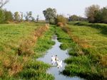
The most important hydro-geological collectors are clays, gravels and sands. The whole area belongs to the Váh River Basin. There are small watercourses (streams), mainly with a soil ameliorating (land draining) function, relatively low flow rates and an unsatisfactory quality of water. These anthropogenic micro-river-basins underwent vast water management adjustments. Only some small streams have an unadjusted bed. Most of the watercourses have a strong oxygen deficiency and a high level of eutrophication. North of the urban area, there is an irrigation water reservoir with an area of 1 ha used as a pond. The groundwater is stabilized at a depth of 2.9 to 3.5 m below the surface. There is a geothermal well at the south-eastern border of the urban area reaching a depth of 2,406 m and a temperature of 68 ° C to 71 ° C.
(Tóth 2012; Master Plan of Tvrdošovce Municipality 2006; Landscape Atlas of the Slovak Republic, 2002)
- Climate, Temperature, Precipitation & Wind
The site is located in the hottest areas of Slovakia - the Danube Lowland. It belongs to the warm climate zone (warm and dry district with mild winter) and the lowland sub-zone of Slovak climate with prevailing oceanic influence.
The average annual air temperature ranges between 9 and 10 ° C. The average annual temperature of the active soil surface is higher than 12 ° C. The warmest month is July with an average air temperature of 19.7 ° C. The coldest month is January with an average air temperature of -2.1 ° C. There are on average 15 tropical days a year (days with a temperature above 30 ° C), 66 summer days (days with the highest air temperature ≥ 25 ° C) and 22 ice days (days with an air temperature of 0 ° C).
The mean annual rainfall is 541 mm - the highest rainfall is in June and July (58 mm). The maximum annual rainfall is 834 mm; the minimum annual rainfall is 308 mm. Snow cover lasts on average 37 days a year, the average maximum snow cover is 20 cm. Duration of the sunshine is approximately 2,200 hours per year. The average snow cover ranges between 6.2 and 16.8 cm. The average number of days with snow is 36, the maximum number of days with snow is 87 and the lowest number of days with snow is 3.
There is a prevailing north-westerly windflow, the overall wind conditions are mild, the average wind speed ranges from 2.6 to 4.6 metres per second.
(Tóth 2012; Landscape Atlas of the Slovak Republic, 2002)
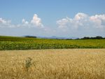
- Current Land Use Structure
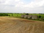
Arable land (43.92 km2 / 79 %); Built-up area (3.44 km2 / 6 %); Permanent grasslands (2.84 km2 / 5 %); Bodies of water (1.67 km2 / 3 %); Gardens (1.26 km2 / 2 %); Orchards (0.83 km2 / 2 %); Vineyards (0.62 km2 / 1 %); Forests and Woods (0.41 km2 / 1 %); Other areas (0.58 km2 / 1 %)
(Master Plan of Tvrdošovce Municipality 2006)
- Cultural Features, Local Identity, Architectural & Spatial Landmarks
The image of rural settlements and landscapes in the Danube Lowland is significantly formed by extensive agriculture with small forests and non-forest woody vegetation such as accompanying vegetation of field roads, railways, watercourses or other linear and areal elements of the landscape. Tvrdošovce can be understood in this context as a representative case study of large rural settlements in agricultural lowlands of south-western Slovakia. The perceived landscape is a far-reaching flatland that one may call "horizon landscape". The perceived landscape image is usually framed in by non-forest woody vegetation formations as only one smaller mountain range is visible in the distance (ranging from 142 to 829 MASL).
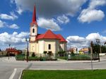
The main architectural landmark of Tvrdošovce as well as of other rural settlements in this region is the baroque church with a distinctive tower visible from far when approaching the small town. This architectural landmark is culturally bound to the perception of the site and therefore significantly forms the local identity through its cultural and historical legacy. Very specific landscape features are also other sacral elements in the form of small architecture, such as small sacral monuments, roadside crosses or other sacred sculptures usually accompanied by old deciduous trees such as Aesculus hippocastanum (in this region) and other trees such as Tilia sp., Quercus sp. and other species.
The most distinctive spatial feature of the town is the historic centre with a wide linear open space framed in on both sides by low architectural volumes (1-2 storey-buildings, mostly housing with front gardens). The public part of the open space consists of a central green space which is framed in by a road with pathway. The uniqueness of this streetscape is underlined by the central green space and the historical legacy of the oldest part of the urban area. The site is dominated by the main architectural landmark - the church located in the geographical centre of the historical town centre. This distinctive spatial arrangement of rural settlements is referred to as Anger or Angerdorf (in German literature), Náves (in Slovak and Czech literature) or Orsós Falu (in Hungarian literature). As the Anglo-Saxon urban development is different from the one in Central Europe, it is hard to define a relevant English equivalent to these terms, but a similar urban structure is referred to as The Common or Village with a Common or Green Village in English literature.
- History & Dynamics from the Early Bronze Age till the 1950s
The first signs of settlement date back to the Early Bronze Age and later to the Early and Late Roman Period. The famous Limes Romanus stretched about 2-3 km south of the settlement. After approximately 2 centuries of Slavonic settlement, the first Hungarian settlement is dated back to 970-1020, approximately a century after the arrival of Hungarian settlers to the Danube Lowland, due to the marshy character of the landscape. This swampy land was a kind of protective space for the inhabitants throughout the centuries till the Middle Ages.
The first written report dates back to 1221. The settlement laid on an important medieval road from Budapest to Bohemia and Poland. The Tatars bypassed the village in 1241 because of the swampy ground.
In 1332 King Károly I. mentions the settlement under the name Turdesqed. In the 14th century the original church was built as a Romanesque chapel, later rebuilt with some elements of the Early Gothic. The settlement was intensively developing in the 13th and 14th century and is mentioned as Tardoskedde, Turdaskeddi, Turdesqued, Tardos Kegy and other variations (stabilized in the late 19th century to Tardoskedd).
In the 16th century, the settlement is already mentioned as a developed central village. It is mentioned among the richest villages of the region. During the Turkish incursions, the inhabitants fled to the marshland called Faluhely in the surrounding landscape for almost 100 years.
Emperor Ferdinánd III. confers the right of small town "Mezőváros" (Lat. Oppidum, Eng. Market Town - ruled by a squire; which had the right to organize markets, but did not have the right to build a fortification or town wall, only paling was allowed - Author´s Note). In the second half of the 17th century, Turkish troops plundered the settlement. The inhabitants hid again in the marshlands which surrounded the town. In the tax register from 1664, the town is referred to as personal property of a Turkish Pasha. The Nové Zámky Fortress (near Tardoskedd) was conquered (reclaimed) in 1685 by the imperial chieftain Charles of Lorraine.
In the 18th century, the development of the settlement was marked by the Rákóczi Uprising (Rákóczi conquered the Nové Zámky Fortress in 1704). After this, the settlement becomes a big military camp with a military postal system. Based on a local legend/tradition, there was a battle between the Kuruc army (rebels against the Habsburgs - Author´s note) and the imperial army at the so called Rákóczi Hill (located in the present cemetery and marked with a historic monument - Author´s note), where hundreds of imperial (Habsburg) soldiers were conquered. In memory of winning the battle, a monument was built on the mentioned hill.
The church was vastly rebuilt in the period between 1707 and 1725 (into the present Baroque style - Author´s note); in 1753 a Calvary was built at the church. Under the reign of Maria Theresia (1740-1780), Tardoskedd became an important town on the royal road from Vienna to Buda with the right to organize markets. There were famous regional cattle fairs, possibility of horse re-harness and a large royal hotel near the town, in Csike, where even Maria Theresa stayed overnight several times. According to the census from 1779, the town had 2288 inhabitants.
After the revolution (1848-1849) the building of the railway from Budapest to Vienna through Marchegg was finished and opened in 1850. The first permanent post office was established in 1868.
After World War II., many privately owned properties were confiscated in 1948/1949 - all shops and inns were expropriated and managed by Jednota (consumer cooperative "Unity" - Author´s Note). In February 1950, the Unified Cooperative Farm was established, in order to manage the collectivisation of agriculture in the town. Besides expropriation of privately owned establishments and collectivisation of agricultural land, the town was markedly influenced by eviction and deportation of inhabitants. In 1948-1954, a sports complex was established in the garden of the wealthy Juhász Family Farmyard. Next to the stadium a swimming pool was built in 1955-1957.
(Tvrdošovce Municipality 2014; Tóth 2012-2014)
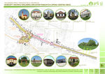
- Illustrations: maps; sketches; short descriptive analyses
- Illustrations
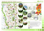
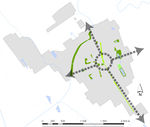
Micro-Regional Context
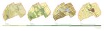
Landscape Structure Dynamics
Components and Features of the Current Landscape Structure
Landscape History - 18th Century
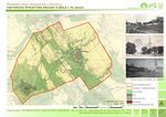
Landscape History - 19th Century
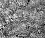
Landscape History - Spatial Context and Landscape Structure just before Collectivization of Agriculture in 1950
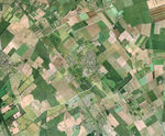
Landscape Reality - Current Spatial Context and Landscape Structure


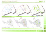
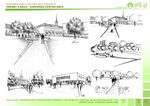
Analytical drawings
- The following analytical schemes and drawings aim at visualising potentials of the Green Infrastructure in Tvrdošovce
- Analytical Drawings
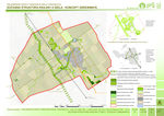
Green Infrastructure Potentials
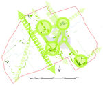
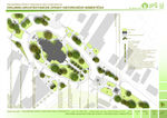
Green Space Connectedness - Municipal Level
Green Infrastructure providing Linkages between Settlement and Landscape - Urban-Area Level
Urban Context of the Green Infrastructure Core


Green Infrastructure benefits for this site
Thinking about green infrastructure as a design concept and planning strategy, multiple benefits could be achieved at the site of the case study encouraging thereby the implementation of the European Landscape Convention. Green Infrastructure can be considered as a relevant tool to respond to the following issues in rural cultural landsacpes represented by the case study of Tvrdošovce:
Connectivity / connectedness of green spaces in the intra-urban and extra-urban area of rural settlements and agricultural landscapes which surround them has been disrupted by interventions in the previous century - first intensification of agriculture in the first half of the century, then collectivisation of agriculture in the middle of the century and some minor intervations into the connectivity since then. Therefore, connectedness of green spaces in the contemporary rural cultural landscapes should be improved.
Sustainable water management provided by green infrastructure could restore the landscape drained in the previous century due to intensification of agricultural production. Green infrastructure could become a strategic planning tool which might help to "return" water into the landscape and keep it there, allow its circulation, improving thereby the local climate and wetlend habitats.
Permeability and accessibility of the landscape has been significantly reduced by intensification and collectivisation of agriculture in the previous century. Green infrastructure represents therefore a potential to improve these landscape qualities for users by implementing greenways allowing people to access the agricultural landscape and to get through it to the surrounding rural settlements.
Social benefits of green infrastructure implementation at this site consist in renewal of the linkage between settlement and landscape and between man and landscape, one of the social benefits is also an improvement of the permeability and accessibility mentioned in the previous paragraph, while other social benefits consist in the improvement of the perceived landscape and landscape image as well as the landscape experience.
Ecological benefits are mainly related to the improvement of the connectivity and connectedness in the landscape as well as to the restoration of the water system. Connected green systems might allow a better wildlife mobility, while restored water systems could provide space for valuable wetland habitats.
Potential for multifunctionality
A specificity of Green Infrastructure is that it provides multiple functions and benefits. In the case of Tvrdošovce, green infrastructure elements could improve the connectedness of green spaces in the settlement and landscape, while serving as greenways for inhabitants and agro-tourists, wildlife corridors, stormwater managing elements, while restoring the cultural and historical legacy of this landscape.
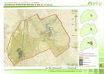
Projective drawings
- How could this case study change in the near future? (in 1-2 years)
- In the short term (near future), the existing components of the green infrastructure in the intra-urban and extra-urban area should be improved, e.g. by a better care of existing trees and by planting new trees.
- How could it look like in 10-15 years?
- In a long term, a functioning and well developed green space system should be developed in the settlement and its surrounding landscape, which would provide all multiple functions, services and benefits that a well developed green infrastructure should provide. In this context, the linkages and connections between the existing green space systems should be improved and strengthened in order to develop a valuable continuous green infrastructure in the rural (agri)cultural landscape.
- Projective Drawings
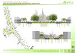
Green Infrastructure Improvements in the Historic Streetscape of Tvrdošovce I
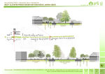
Green Infrastructure Improvements in the Historic Streetscape of Tvrdošovce II
Design for Greening the Town Centre
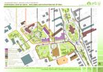
Visions for Conversion of the Town Centre by Green Infrastructure Tools
Visions for Re-Designing the Church Garden in the Town Centre
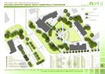
Visions for a new Green Market Square in the Town Centre
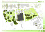
Visions for Re-Designing the Open Spaces around the Community Centre
Visions for Greening the Town Centre and the Surrounding Rural Landscape


Summary and conclusion
Green Infrastructure is a strategic tool of contemporary landscape planning and architecture with a strong potential to restore rural cultural landscapes through a better implementation of the European Landscape Convention as well as related landscape policies and directives. Green infrastructure provides not only wildlife with well connected bio-corridors and humans with a better access to the landscape but serves at the same time also as a good design tool to manage water in the landscape and to restore the cultural and historical legacy of the landscape.
Image Gallery
Exploring the Features of the Landscape within and around Tvrdošovce
- Image Gallery
Regional Identity
Landscape Context
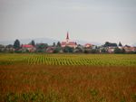
Settlement & Landscape Image
Agricultural Landscapes
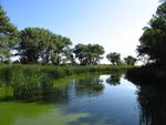
Water in the Landscape
Agricultural Legacy
Architectural Landmark
Wildlife


References
BUDA, František. 2009. Tvrdošovce-Tardoskedd: Kapitoly o minulosti, súčasnosti, obyvateľstve a zaujímavostiach Tvrdošoviec. Komárno: Print-K, 2009, 334 s., ISBN 978-80-970181-9-1.
TÓTH, Attila - FERIANCOVÁ, Ľubica. 2013. Green Infrastructure in the Context of Rural Space Restoration and Design. In: Nordic Journal of Architectural Research. Vol. 25, No. 2. pp. 187-212. ISSN 1893-5281.
TÓTH, Attila. 2013. Green Infrastructure: Planning and Design of Rural Landscapes - Case Study: Cergát-Váh, Tvrdošovce. In: Kubišta, R. (eds.): Trendy v krajinotvorbe [Trends in Landscape Design]. Nitra: Slovak University of Agriculture, 2013, pp.52-59. 59 p. ISBN 978-80-552-1033-9.
TÓTH, Attila. 2013. Green Infrastructure Planning for Sustainable Rural Development. In: Neményi, M. et al. (eds.): Science for Sustainability: International Scientific Conference for PhD Students: Proceedings, University of West Hungary, Győr, March 19-20, 2013. Sopron: University of West Hungary Press, 2013, pp. 392-397. 414 p. ISBN 978-963-334-103-2.
TÓTH, Attila. 2013. Current challenges in rural development in terms of landscape planning and landscape architecture: Case study of Tvrdošovce, Slovakia / A vidékfejlesztés aktuális tájtervezési és tájépítészeti kihívásai: Esettanulmány - Tardoskedd, Szlovákia. In: Talentum - Hensch Árpád nyomdokain: A Gazdálkodásban publikált PhD hallgatók és kutatók III. országos tudományos konferenciája [CD]. Mosonmagyaróvár : University of West-Hungary, 2013, pp. 1-6. 178 p. ISBN 978-963-334-108-7 (CD with full papers), ISBN 978-963-334-107-0 (printed proceeding of abstracts, p. 62).
TÓTH, Attila - SUPUKA, Ján. 2014. Greenways: A Landscape Planning Tool for Restoration of Linkages in the Landscape. In: Berichte des Instituts Verkehr und Raum: How to push the implementation of the European Green Belt by landscape policy instruments? Erfurt: Fachhochschule, Vol. 18, No. 1. pp. 93-103. ISSN 1868-8586.
TÓTH, Attila. 2013. Rural Landscape Transformations by the Example of the Village Tvrdošovce in Slovakia. In: Stará, Kristýna (Eds.): Landscape Transformations of the Post-Communist Countries. Prague: Czech Technical University, 2013, pp.54-59. 200 p. ISBN 978-80-01-05431-4.
TÓTH, Attila - FERIANCOVÁ, Ľubica. 2013. The Role of Landscape Architecture in Rural Development. In: Škarpa, P. et al. (Eds.): MendelNet 2013 - Proceedings of International PhD Students Conference. Brno: Mendel University, 2013, pp.516-520. 955 p. ISBN 978-80-7375-908-7.
TÓTH, Attila - FERIANCOVÁ, Ľubica. 2014. By Improvement of the Green Infrastructure towards Sustainable Landscapes and Resilient Environments. In: G20 Youth Forum 2014 Conference Proceedings, Garmisch-Partenkirchen, Germany. Genève: G8&G20 Alumni Association, 2014, pp.405-410. 695 p. ISSN 2297-0134.
TÓTH, Attila - BIHUŇOVÁ, Mária - HALAJOVÁ, Denisa - ŠTĚPÁNKOVÁ, Roberta. 2014. Interactions of Recreation and Landscape Protection in Slovakia. In: Journal of Landscape Management. Vol. 5, No. 1. pp. 51-55. ISSN 1804-2821.
TÓTH, Attila - FERIANCOVÁ Ľubica. 2013. Zelená infraštruktúra ako efektívny nástroj na ochranu a tvorbu udržateľnej krajiny [Green Infrastructure as an Efficient Tool for Protection and Design of Sustainable Landscapes]. In: Igaz, D. (eds.): Recenzovaný zborník z medzinárodnej vedeckej konferencie – ENVIRO Nitra 2013 [reviewed scientific proceedings]. Nitra: Slovak University of Agriculture, 2013, pp.179-187. 203 p. ISBN 978-80-552-1101-5.
TÓTH, Attila – FERIANCOVÁ, Ľubica. 2012. Krajinárske úpravy vidieckeho sídla Tvrdošovce [Landscape Architectural Design of the Rural Settlement Tvrdošovce]. In: Štěpánková, R. (eds.): Zborník príspevkov zo študentskej vedeckej konferencie FZKI 2012 [Proceeding from the Student Scientific Conference]. Nitra : SPU v Nitre, 2012, pp. 148-154. 154 p. ISBN 978-80-552-0888-6.
TÓTH, Attila – FERIANCOVÁ, Ľubica. 2011. Vidiecke sídlo – súčasť kultúrnej krajiny [Rural Village as Part of the Cultural Landscape]. In: Štěpánková, R. (eds.): Zborník príspevkov zo študentskej vedeckej konferencie FZKI 2011 [Proceeding from the Student Scientific Conference]. Nitra : SPU v Nitre, 2011, pp. 227-233. 233 p. ISBN 978-80-552-0676-9.
TÓTH, Attila. 2012. Landschaftsarchitektonische Neugestaltung und Entwicklung ländlicher Räume: Projektarbeit [Landscape Architectural Restoration and Development of Rural Spaces: project thesis]. München : GRIN Verlag GmbH, 2012. 24 p. ISBN 978-3-656-31030-3 (e-book); ISBN 978-3-656-31058-7 (book).
TÓTH, Attila. 2011. Theorie der Grünen Netze [Theory of Green Networks]. In: Damyanovic, D. (eds.): Nachhaltige Stadtplanung und –entwicklung am Beispiel der Stadt Salzburg : Projekt [Sustainable urban planning and development on example of Salzburg City : project]. Vienna : BOKU Wien, 2011. pp. VII_3-6, 205 p.
TÓTH, Attila. 2013. Tvorba plôch verejnej zelene vo vidieckom priestore [Public Green Space Design in Rural Areas] [online]. In: Certifikácia ubytovacích zariadení na vidieku a regionálne značenie produktov a služieb - odborný seminár. Nitra : Národná sieť rozvoja vidieka, 2013. 7 p. Available at: http://www.nsrv.sk/download.php?1058 [Accessed 08 October 2013].
TÓTH, Attila. 2012. Krajinárske úpravy vidieckeho sídla Tvrdošovce : diplomová práca [Landscape Architectural Design of the Rural Settlement Tvrdošovce : master thesis]. Nitra : SUA, 2012. 67 A3 p.
About categories: You can add more categories with this tag: "", add your categories