Green Infrastructure 2014 Working Group J - Case Study 1: Difference between revisions
| Line 34: | Line 34: | ||
== Rationale: Why is this case interesting? == | == Rationale: Why is this case interesting? == | ||
''Black Forest/Schwarzwald is the overgrown mountain region in the southern part of Baden-Württemberg, Germany and its name is derived from " the dark canopy of evergreens". Black Forest is located on eastern part of the river Rhine between Karlsruhe and Basel (Switzerland), with the length of 150 km and 60 km width.The highest pick of blackforest mountains and also the highest in Germany outside of the Alps is called Feldberg. Zell im Wiesental, is a town in the district of Lörrach, located in the extreme southern part of Black Forest very close to the Swiss border and it is situated on the river Wiese, which rises from | ''Black Forest/Schwarzwald is the overgrown mountain region in the southern part of Baden-Württemberg, Germany and its name is derived from " the dark canopy of evergreens". Black Forest is located on eastern part of the river Rhine between Karlsruhe and Basel (Switzerland), with the length of 150 km and 60 km width.The highest pick of blackforest mountains and also the highest in Germany outside of the Alps is called Feldberg. Zell im Wiesental, is a town in the district of Lörrach, located in the extreme southern part of Black Forest very close to the Swiss border and it is situated on the river Wiese, which rises from Feldberg and it is the right branch of the Rhine. The case site is a village belongs to Zell, called Atzenbach with 3.68 km2, 447 m hight and 782 inhabitants. | ||
There | There is one kindergarten, one primary school and a few small stores in the village, Zell offers more supermarkets in the center. In Atzenbach the population is not increasing rather than specially young people seem to moving to bigger cities to have the benefits of job and social facilities. The economic benefit from local farmers shrinks due to global pressure on food prices. The interesting point is if no new houses or structures supposed not to get built in the area and there would be no activities on the farms, as the hills around the valley are potentially ready to get covered by trees and green infrastructure, what will happen to the valley? | ||
== Author's perspective == | == Author's perspective == | ||
Revision as of 21:19, 26 November 2014
---> back to group page working group J
Schwarzwald-Germany, Negar Mehryar
| Atzenbach valley | name of the site | |
| Germany | country | |
| Schwarzwald, Zell im Wiesental | place | |
| Negar Mehryar | author | |

| ||
|
| ||
Rationale: Why is this case interesting?
Black Forest/Schwarzwald is the overgrown mountain region in the southern part of Baden-Württemberg, Germany and its name is derived from " the dark canopy of evergreens". Black Forest is located on eastern part of the river Rhine between Karlsruhe and Basel (Switzerland), with the length of 150 km and 60 km width.The highest pick of blackforest mountains and also the highest in Germany outside of the Alps is called Feldberg. Zell im Wiesental, is a town in the district of Lörrach, located in the extreme southern part of Black Forest very close to the Swiss border and it is situated on the river Wiese, which rises from Feldberg and it is the right branch of the Rhine. The case site is a village belongs to Zell, called Atzenbach with 3.68 km2, 447 m hight and 782 inhabitants. There is one kindergarten, one primary school and a few small stores in the village, Zell offers more supermarkets in the center. In Atzenbach the population is not increasing rather than specially young people seem to moving to bigger cities to have the benefits of job and social facilities. The economic benefit from local farmers shrinks due to global pressure on food prices. The interesting point is if no new houses or structures supposed not to get built in the area and there would be no activities on the farms, as the hills around the valley are potentially ready to get covered by trees and green infrastructure, what will happen to the valley?
Author's perspective
I am from Iran, Tehran and my Bachelor degree is in Architecture. I studied master of landscape architecture in hfwu Nürtingen-Geislingen, in IMLA program. Now I am living with a German family in the chosen place, Atzenbach where the natural beauty is breathtaking as you see the most ever-green areas in my environment or in autumn the mixture of colorful leaves spreading around gives magnificent scenes. Every day I need to travel to Lörrach to attend an intensive German course and use public transportation system which I found it so accessible and easy to get to the destination although the valley seems neglected. The appropriate bicycle roads along the river Wiese and also upon the hills are so common to use for different purposes, like hiking, biking and get to the center where the supermarkets and some other stores plus restaurants are located. But not more! For me who comes from the crowded metropolitan city, living in this valley is obviously a huge contrast also interesting and at the same time boring. what is your professional/educational background and your relation to the site?
Landscape and/or urban context of your case
- Biogeography, cultural features, overall character, history and dynamics
- Illustrations: maps; sketches; short descriptive analyses
- Illustrations
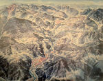
Oberes Wiesental overview
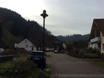
Atzenbach.region1
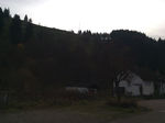
Atzenbach.region2


Analytical drawings
- Please use analytical drawing for visualising the conflicts/potentials of your site
- Analytical Drawings
- Your drawing.jpg
your drawing
- Your drawing.jpg
your drawing
- Your drawing.jpg
your drawing
- Your drawing.jpg
your drawing
Green Infrastructure benefits for this site
Look again at the multiple benefits of green infrastructure - what could be achieved in your site and which are most relevant?
Potential for multifunctionality
Green infrastructure has typically multiple functions. What could be achieved for your site in this respect?
Projective drawings
- How would you like this case to change in the near future? (in 1-2 years)
- you may add a short explanation here
- And how could it look like in 10-15 years?
- you may add a short explanation here
- Projective Drawings
- Yourdrawing.jpg
projective drawing
- Yourdrawing.jpg
projective drawing
- Yourdrawing.jpg
projective drawing
- Yourdrawing.jpg
projective drawing
Summary and conclusion
- 100 words approx.
Image Gallery
Please add further images/photos here
- Image Gallery
- Yourimage.jpg
your image text
- Yourimage.jpg
your image text
- Yourimage.jpg
your image text
- Yourimage.jpg
your image text
- Yourimage.jpg
your image text
- Yourimage.jpg
your image text
- Yourimage.jpg
your image text
- Yourimage.jpg
your image text
References
- please add your references here
About categories: You can add more categories with this tag: "", add your categories