Collaborative Design Planting Design Working Group 11: Difference between revisions
No edit summary |
|||
| (25 intermediate revisions by 3 users not shown) | |||
| Line 1: | Line 1: | ||
---> back to group page [[Planting_Design_2013_-_Working_Group_11|working group 11]] | ---> back to group page [[Planting_Design_2013_-_Working_Group_11|working group 11]] | ||
''' | '''Waterfront green space improvements, Nagold, Germany''' | ||
| Line 7: | Line 7: | ||
{| align="right" width="300pt" style="background:Gainsboro; color:black" | {| align="right" width="300pt" style="background:Gainsboro; color:black" | ||
|- | |- | ||
| '''Name''' ||style="background:Lavender"| '' '' | | '''Name''' ||style="background:Lavender"| ''Waterfront green space improvements'' | ||
|- | |- | ||
| '''Location''' || style="background:Lavender"|''along the river Waldach, Nagold'' | | '''Location''' || style="background:Lavender"|''along the river Waldach, Nagold'' | ||
| Line 15: | Line 15: | ||
| '''Authors''' || style="background:Lavender"|''Andra Spornic, Andreia Oshiro Gama, Masaki Ikeda'' | | '''Authors''' || style="background:Lavender"|''Andra Spornic, Andreia Oshiro Gama, Masaki Ikeda'' | ||
|- | |- | ||
| colspan="3" align="center" style="background:silver"| [[Viaduct Nagold.jpg]] | | colspan="3" align="center" style="background:silver"| [[Image:Viaduct Nagold.jpg|300px]] | ||
|- | |- | ||
| ||style="background:Lavender"| | | ||style="background:Lavender"| | ||
| Line 35: | Line 35: | ||
== Landscape and/or urban context of your case == | == Landscape and/or urban context of your case == | ||
*'''Biogeography''' | *'''Biogeography''' | ||
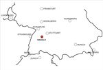
Nagold has today an integrated urban green infrastructure, result from the Garden Exhibition which took place in the city center in 2012. The city park and city garden are on both sides of the river Nagold and connected to another park, the Riedbrunnen, through the renaturated river Waldach as a green corridor. | |||
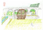
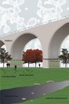
This green corridor along the Waldach River, which crosses the city from north to south, stops at the Viaduct, an important landmark in Nagold landscape that cutsthe center and its periphery. Beyond the viaduct no plan or design was developedso far, what reveals a disconnection between this area and the city center. | |||
*'''Cultural features''' | *'''Cultural features''' | ||
In the Brunnen Park, north side of viaduct, there are sport areas very uses by teenagers and a playground, each one in one side of the river. On weekends they are full of people, especially on summer, when kids also play in the Waldach’s water. | |||
*'''Overall character''' | *'''Overall character''' | ||
The urban green structure is clear and connected in the city center and is quite intensive used by residents and visitors. However the viaduct is a strong element on landscape and seems to cut this green structure from the south part of Nagold. The river Waldach runs to the south, but has apparently no relation to its surrounding in this part. | |||
*'''History and dynamics''' | *'''History and dynamics''' | ||
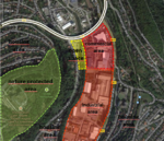
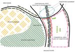
Nagolds’ City Planners together with Mr. Stefan Fromm, the landscape architect responsible for Garden exhibition project, decided to concentrate the event area around the old town until the borders of the viaduct on the south. The neighborhood beyond this border is composed by houses and residential building, commercial area and super-market, industrial buildings, all surrounded by nature protected areas. Here the car traffic is more intensive in comparison to downtown and we see fewer pathways forpedestrians. | |||
* Illustration: Map; sketches; short descriptive analyses | * Illustration: Map; sketches; short descriptive analyses | ||
<gallery caption="Context" widths="150px" heights="150px" perrow="2"> | |||
Image:Nagold localization.jpg|Location of Nagold | |||
Image:Relation green-built surfaces small.jpg|Report green-built surfaces | |||
</gallery> | |||
== What are the objectives of your design? == | == What are the objectives of your design? == | ||
The quality of the green spaces in Nagold is clearly perceived in the city center and we intent to think about possibilities to expand this quality to other parts of the city. We will start focusing on the south part, where the gap on the green structure is more evident, exploring the area along the Waldach river. | |||
== Analytical drawings == | == Analytical drawings == | ||
| Line 75: | Line 61: | ||
<gallery caption="Analytical Drawings " widths="150px" heights="150px" perrow="4"> | <gallery caption="Analytical Drawings " widths="150px" heights="150px" perrow="4"> | ||
Image: | Image:Study area analysis.PNG|Functional zoning | ||
Image: | Image:Existing vegetation.jpg|Existing vegetation | ||
Image: | Image:SKMBT C30014012115550.jpg|Traffic system | ||
Image: | Image:SKMBT C30014012115560.jpg|North perspective | ||
</gallery> | </gallery> | ||
| Line 85: | Line 71: | ||
<gallery caption="Projective Drawings " widths="150px" heights="150px" perrow="4"> | <gallery caption="Projective Drawings " widths="150px" heights="150px" perrow="4"> | ||
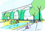
Image: | Image:Perspective Nagold.jpg|Projective drawing: Waldach river | ||
Image: | Image:Img012_(800x595).jpg|projective drawing 2 | ||
Image: | Image:Nagold aoshiro projective drawing1.jpg|projective drawing 3 | ||
Image: | Image:Nagold aoshiro projective drawing2.jpg|projective drawing 4 | ||
</gallery> | </gallery> | ||
| Line 95: | Line 81: | ||
<gallery caption="Design Synthesis Drawings" widths="150px" heights="150px" perrow="4"> | <gallery caption="Design Synthesis Drawings" widths="150px" heights="150px" perrow="4"> | ||
Image: | Swot2;Masa.jpg|Synthesis drawing_Masaki Ikeda | ||
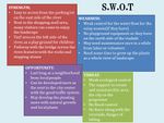
Image: | Image:SWOT 700.jpg|SWOT analyze_Andra Spornic | ||
Image: | Image:Swot andreia.jpg|SWOT analyze_Andreia | ||
Image: | Image:Section explanations 700px.jpg|Section through the river Waldach | ||
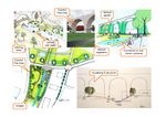
Image:Projective strengths.pdf-page-001.jpg|Design synthesis | |||
</gallery> | </gallery> | ||
== Summary of the collaborative process == | == Summary of the collaborative process == | ||
'' | |||
'''Teamwork''' | |||
'''Work in group''' is always a '''challenging''' job but also an '''opportunity''' to learn from others experiences. Site selection was one of the difficult tasks in our group, because of the different perspectives and as well we imagined a different type of analysis of collaborative design. Time synchronization was a factor that has slowed down the process of our project, but until the end we managed to get through obstacles and propose a concept that fits to the chosen site in Nagold city, Germany. | |||
== Image Gallery == | == Image Gallery == | ||
| Line 108: | Line 99: | ||
<gallery caption="Image Gallery" widths="150px" heights="150px" perrow="4"> | <gallery caption="Image Gallery" widths="150px" heights="150px" perrow="4"> | ||
Image: | Image:DSC 1378.jpg|image 1 | ||
Image: | Image:IMG 1823.JPG|image 2 | ||
Image: | Image:IMG 1846.JPG|image 3 | ||
Image: | Image:IMG 1825.JPG|image 4 | ||
</gallery> | </gallery> | ||
== References == | == References == | ||
http://www.nagold.de/de/landesgartenschau | |||
http://www.gartenschau-bilder.de/index.php/galerie/category/themengaerten-auf-der-lgs | |||
Latest revision as of 01:49, 8 February 2014
---> back to group page working group 11
Waterfront green space improvements, Nagold, Germany
| Name | Waterfront green space improvements | |
| Location | along the river Waldach, Nagold | |
| Country | Germany | |
| Authors | Andra Spornic, Andreia Oshiro Gama, Masaki Ikeda | |
| ||
|
| ||
Landscape and/or urban context of your case
- Biogeography
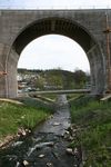
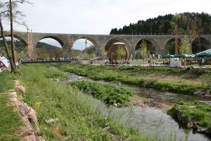
Nagold has today an integrated urban green infrastructure, result from the Garden Exhibition which took place in the city center in 2012. The city park and city garden are on both sides of the river Nagold and connected to another park, the Riedbrunnen, through the renaturated river Waldach as a green corridor. This green corridor along the Waldach River, which crosses the city from north to south, stops at the Viaduct, an important landmark in Nagold landscape that cutsthe center and its periphery. Beyond the viaduct no plan or design was developedso far, what reveals a disconnection between this area and the city center.
- Cultural features
In the Brunnen Park, north side of viaduct, there are sport areas very uses by teenagers and a playground, each one in one side of the river. On weekends they are full of people, especially on summer, when kids also play in the Waldach’s water.
- Overall character
The urban green structure is clear and connected in the city center and is quite intensive used by residents and visitors. However the viaduct is a strong element on landscape and seems to cut this green structure from the south part of Nagold. The river Waldach runs to the south, but has apparently no relation to its surrounding in this part.
- History and dynamics
Nagolds’ City Planners together with Mr. Stefan Fromm, the landscape architect responsible for Garden exhibition project, decided to concentrate the event area around the old town until the borders of the viaduct on the south. The neighborhood beyond this border is composed by houses and residential building, commercial area and super-market, industrial buildings, all surrounded by nature protected areas. Here the car traffic is more intensive in comparison to downtown and we see fewer pathways forpedestrians.
- Illustration: Map; sketches; short descriptive analyses
- Context
What are the objectives of your design?
The quality of the green spaces in Nagold is clearly perceived in the city center and we intent to think about possibilities to expand this quality to other parts of the city. We will start focusing on the south part, where the gap on the green structure is more evident, exploring the area along the Waldach river.
Analytical drawings
Please add four analytical sketches/drawings (or montages/schemes) of your case. Every group member needs to contribute at least one drawing.
- Analytical Drawings
Projective drawings
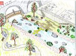
Please add four projective sketches/drawings (or montages/schemes), of course with an emphasis on planting design/vegetation aspects. Every group member needs to contribute at least one drawing representing his/her individual ideas.
- Projective Drawings
Design Synthesis
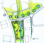
Please analyse the individual approaches presented so far and evaluate their strengths and weaknesses (you may use the SWOTanalysis model). Try to create a synthesis and represent it with a plan and some sketches. You can still use drawings/sketches.
- Design Synthesis Drawings
Summary of the collaborative process
Teamwork
Work in group is always a challenging job but also an opportunity to learn from others experiences. Site selection was one of the difficult tasks in our group, because of the different perspectives and as well we imagined a different type of analysis of collaborative design. Time synchronization was a factor that has slowed down the process of our project, but until the end we managed to get through obstacles and propose a concept that fits to the chosen site in Nagold city, Germany.
Image Gallery
You may add a series of images/photos in addition to the sketches/drawings
- Image Gallery
References
http://www.nagold.de/de/landesgartenschau
http://www.gartenschau-bilder.de/index.php/galerie/category/themengaerten-auf-der-lgs
About categories: You can add more categories with this tag: "", add your categories
