Collaborative Design Planting Design Working Group 17: Difference between revisions
No edit summary |
|||
| (69 intermediate revisions by 3 users not shown) | |||
| Line 1: | Line 1: | ||
---> back to group page [[Planting_Design_2013_-_Working_Group_17|working group 17]] | ---> back to group page [[Planting_Design_2013_-_Working_Group_17|working group 17]] | ||
''''' | '''''Prahova's Riverbed Valley''''' | ||
| Line 12: | Line 12: | ||
| '''Country''' || style="background:Lavender"|''Romania'' | | '''Country''' || style="background:Lavender"|''Romania'' | ||
|- | |- | ||
| '''Authors''' || style="background:Lavender"|''Merchedes | | '''Authors''' || style="background:Lavender"|''Merchedes Perez, Ma Junge, Tanase Gabriel-Iulian'' | ||
|- | |- | ||
| colspan="3" align="center" style="background:silver"| [[Image: | | colspan="3" align="center" style="background:silver"| [[Image:perspective cover.jpg|300px]] | ||
|- | |- | ||
| ||style="background:Lavender"| | | ||style="background:Lavender"| | ||
| Line 21: | Line 21: | ||
|width=300 | |width=300 | ||
|height=200 | |height=200 | ||
|lat=45. | |lat=45.182702 | ||
|lng=25. | |lng=25.676118 | ||
|zoom= | |zoom=14 | ||
|centermarker=yes | |centermarker=yes | ||
|maptypecontrol=yes | |maptypecontrol=yes | ||
| Line 33: | Line 33: | ||
== Landscape and/or urban context of your case == | == Landscape and/or urban context of your case == | ||
The site we have selected as a collaborative assignment is the Prahova River Valley, with a considerable smaller region. Mainly the active site for analysis is in direct contact with the Breaza city center. Breaza City segment that we chose was modified a few years earlier due to the landslide. The land aspect has been dramatically changed as well as the vegetation and the woodland. Therefore the aesthetic and functional aspect of this valley will change drastically. | |||
The site is located on the SubCarpethian Area, at a height of 380m-450m that includes Prahova's riverbed. The climate is temperate-continental specific to hilly areas. Also one Important charasteristic of the valley is the quallity of the air due to the ozone and negative ions which makes the air have an therapeutic effect. Furthermore the area has a noticeble bioclamate characterised by the low values of atmopheric pressure due to the air purity. On the other side the geographic position allows the area to have a rich vegetation, especially due to decidous forrests. About the native plants we can mention: ''Populus alba, Betula pendula, Sambucus nigra, Rosa canina, Fraxinus excelsior''. Finally, the surroundings of the site there are formed by 1400 ha of orchards covered with fruited plants, 1500 ha of forrest and 1800 ha of pastures and hayfields. We can say the the site has high quality characteristics that makes it a very interesting site for landscaping. | |||
== What are the objectives of your design? == | == What are the objectives of your design? == | ||
The main objectives of our design are four in total. First one reffers to reclaiming the lost land in the landslide or in the urban transformation of the riverbed, either be woodland or just ground terrain. The second objective is to create a strong physical connection between the center of the city and the new reclaimed land. The third objective is to integrate the new urban developments, for example the hydroplant situated at the base of our site, on the riverbed, into the new design of the valley improving their aethetical and functional values. The fourth and final objective is to minimize the negative impact of the urban development and trying to design the river beams to give them the natural aspect the valley once had. | |||
== Analytical drawings == | == Analytical drawings == | ||
We analyze the site in two aspects: | |||
First, we considered the relationship between the site and people. We realized that the connectivity between the valley and the city is weak, both visually and functionally. And we noticed that there are many good viewpoints on our site but they are undervalued and badly utilized. | |||
Second, on the pure natural aspect, we analyzed the drainage and vegetation of the site. | |||
According to the distribution of plants, we drew the picture of watersheds and runoff. It helps to determine the location of infiltration trenches in our collaborative design. | |||
As to the vegetation, we realized that plants on the slight slope act well as buffer strips. However the riverbed is bare because of the development recently. This is what we should solve in the design later. | |||
Further on, we recognized the vegetation type on the site and divided the site into several zones according to this. We also drew a typical section of the site to show the vegetation dynamic along with the division. | |||
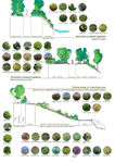
At last we selected some typical species on our site, including trees, shrubs and herbaceous plants. They are native or adaptive to the site and will be used in the planting design later. | |||
<gallery caption="Analytical Drawings " widths="150px" heights="150px" perrow="4"> | <gallery caption="Analytical Drawings " widths="150px" heights="150px" perrow="4"> | ||
Image: | Image:functional analysis.jpg|connectivity disfunctions between the valley and the city | ||
Image: | Image:section_functional analysis copy.jpg|undervalued and unused perch and view points of the Prahova Valley | ||
Image: | Image:G17_BUFFER_STRIP.jpg|Buffer strips: vegetation form and scale | ||
Image: | Image:G17_SECTIONS.jpg|Cross sections | ||
Image:Characterization_of_land_cover.jpg|Characterization of land cover, referred to the vegetation dynamic | |||
Image:Vegetation class Prahova.jpg|1st plant selection: some species from vegetation class of Prahova Valley | |||
</gallery> | </gallery> | ||
| Line 55: | Line 72: | ||
<gallery caption="Projective Drawings " widths="150px" heights="150px" perrow="4"> | <gallery caption="Projective Drawings " widths="150px" heights="150px" perrow="4"> | ||
Image: | Image:perspective_majunge.jpg|Projective basis and natural dynamics | ||
Image: | Image:pathways and stairs.jpg|Strategy for path structures and platforms (rooms) | ||
Image: | Image:G17_drainage.jpg|Strategy for drainage (Integration of hydraulic dynamics) | ||
Image: | Image:Proposal strategy for planting.jpg|Strategy for planting (Landscape integration) | ||
</gallery> | </gallery> | ||
== Design Synthesis == | == Design Synthesis == | ||
This project has a specific starting point: the modification of the landcover caused by the construction of several building, included in a wider hydraulic work. | |||
This work caused the deforestation of land cover and we realized that this was a chance to create a new connection with river Prahova. | |||
At first, we thought of combining two strategies: | |||
- Create a network of pathways, rest areas and viewpoints. | |||
- Restore the natural cover. | |||
We are concerned about two issues(mainly risks): | |||
- The risk of landslides in areas where vegetation had disappeared. | |||
- River dynamics of the Prahova. We should be very cautious about actions that may occur in the riverbed. | |||
Finally, the decisions that we assumed in the master plan were: | |||
1– To Build a network of paths and rest areas connected by trails and steps. | |||
2– To connect the banks with a pedestrian bridge. | |||
3– To solve the drainage by infiltration trenches. | |||
4– To restore the plant cover. | |||
5– To create new planting areas to connect the platforms. | |||
Regarding to the planting, basically we worked with the species from the vegetation class, considering three layers: trees (like ''Betula pendula, Fagus sylvatica or Quercus robur''), srhubs (like ''Crataegus monogyna, Euonymus latifolius, Prunus tenella or Rosa canina'') and herbaceous (like ''Festuca sulcata, Fragaria viridis, Stipa capillata or Paeonia peregrina''). | |||
In each intervention or strategy (that concerns to the planting) predominates one, two or three of them: | |||
- The three layers for restoring the vegetation cover. | |||
- Trees and srhubs for path and steps. | |||
- Srhubs and herbaceous to stabilize the riparian slope. | |||
- Herbaceous for active area of aluvian plain. | |||
- Srhubs and herbaceosus for the new planting areas to connect the platforms. In addition to the species of vegetation class, only in this case, non-native species are introduced. These species are well adapted and have a great ornamental value (some of them, ''Centaurea cyanus, Liatris spicata, Koeleria glauca, Silene vulgaris or Penstemon barbatus''). | |||
Concluding, we consider this work like an approach, a starting point, where the planting design is a tool to connect the projective work with nature. | |||
<gallery caption="Design Synthesis Drawings" widths="150px" heights="150px" perrow="4"> | <gallery caption="Design Synthesis Drawings" widths="150px" heights="150px" perrow="4"> | ||
Image: | Image:SWOT_copy.jpg|Swot analysis | ||
Image: | Image:PLan generale.jpg|General plan | ||
Image: | Image:Planting sketch group17.jpg|Skecthes related to the planting | ||
Image: | Image:vegetation selection_Prahova.jpg|Plant selection with species of vegetation class (native) and well-adapted herbaceous with ornamental values | ||
</gallery> | </gallery> | ||
== Summary of the collaborative process == | == Summary of the collaborative process == | ||
In our case, the colaborative design process was a very interesting one with, hopefully fulfilling result. In the making of the design the water control and vegetation planting were the ideas that gave the site a sustenable design. The proposal potential was of an integrated sustenable design thanks to the influence of the different landcscape designs: spanish, chinese and romaininan. We took into consideration posible floods, possible landslide, and the posibility of the construction development in the aluvian plain. Speaking different languages is a problem everywhere, but in our case we managed to surpass that problem right from the beggining. A succesful design is only by colaborating with other professionals and get new ways of viewing the problem. By collaborating with different people with different culture and background not only we get more experince on working as a team, but new informations about how planting design is viewed and used in other countries. | |||
== Image Gallery == | == Image Gallery == | ||
<gallery> | |||
Image:9 copy.jpg| The Proposed Site. Landslide - Prahova Valley near Breaza | |||
Image:understanding site.jpg| Key elements in understanding the site | |||
</gallery> | </gallery> | ||
== References == | |||
''*http://www.ibiol.ro/plant/Volume%2047/Rev.Roum.Biol.-Biol.Veget.,%202004,%20v.47,%20pp.41-56.pdf'' | |||
''* | |||
''* | ''*http://www.ibiol.ro/plant/volume%2054/Rom.J.Biol.-Plant%20Biol.,%202009,%20v.54,%20n.2,%20pp.157-172.pdf'' | ||
''* | ''*http://www.google.es/url?sa=t&rct=j&q=&esrc=s&source=web&cd=1&ved=0CDAQFjAA&url=http%3A%2F%2Fwww.researchgate.net%2Fpublication%2F235925649_Flora_si_vegetatia_Moldovei_%28Romania%29._I._Flora%2Ffile%2F9fcfd51443bdb3f27d.pdf&ei=FebzUoe4Nqe60QXWw4DYAw&usg=AFQjCNF1aMElEDOfdVJ9qmmkMQ778xaSSA&bvm=bv.60799247,d.d2k'' | ||
''*http://www.e-scoala.ro/geografie/flora_fauna_prahova.html'' | |||
''*http://landscape.cc.unibuc.ro/research/elaborating_and_implementing_an_algorithm_for_landscape_evaluation_and_prognosis.pdf'' | |||
---- | ---- | ||
Latest revision as of 15:18, 7 February 2014
---> back to group page working group 17
Prahova's Riverbed Valley
| Name | Prahova Valley | |||||||||||
| Location | Breaza City | |||||||||||
| Country | Romania | |||||||||||
| Authors | Merchedes Perez, Ma Junge, Tanase Gabriel-Iulian | |||||||||||

| ||||||||||||
| {{#widget:GoogleMaps | width=300 | height=200 | lat=45.182702 | lng=25.676118 | zoom=14 | centermarker=yes | maptypecontrol=yes | overviewmapcontrol=yes | largemapcontrol=yes | scalecontrol=yes
}} | ||
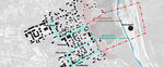
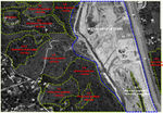
Landscape and/or urban context of your case
The site we have selected as a collaborative assignment is the Prahova River Valley, with a considerable smaller region. Mainly the active site for analysis is in direct contact with the Breaza city center. Breaza City segment that we chose was modified a few years earlier due to the landslide. The land aspect has been dramatically changed as well as the vegetation and the woodland. Therefore the aesthetic and functional aspect of this valley will change drastically.
The site is located on the SubCarpethian Area, at a height of 380m-450m that includes Prahova's riverbed. The climate is temperate-continental specific to hilly areas. Also one Important charasteristic of the valley is the quallity of the air due to the ozone and negative ions which makes the air have an therapeutic effect. Furthermore the area has a noticeble bioclamate characterised by the low values of atmopheric pressure due to the air purity. On the other side the geographic position allows the area to have a rich vegetation, especially due to decidous forrests. About the native plants we can mention: Populus alba, Betula pendula, Sambucus nigra, Rosa canina, Fraxinus excelsior. Finally, the surroundings of the site there are formed by 1400 ha of orchards covered with fruited plants, 1500 ha of forrest and 1800 ha of pastures and hayfields. We can say the the site has high quality characteristics that makes it a very interesting site for landscaping.
What are the objectives of your design?
The main objectives of our design are four in total. First one reffers to reclaiming the lost land in the landslide or in the urban transformation of the riverbed, either be woodland or just ground terrain. The second objective is to create a strong physical connection between the center of the city and the new reclaimed land. The third objective is to integrate the new urban developments, for example the hydroplant situated at the base of our site, on the riverbed, into the new design of the valley improving their aethetical and functional values. The fourth and final objective is to minimize the negative impact of the urban development and trying to design the river beams to give them the natural aspect the valley once had.
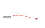
Analytical drawings
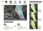
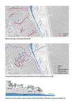
We analyze the site in two aspects:
First, we considered the relationship between the site and people. We realized that the connectivity between the valley and the city is weak, both visually and functionally. And we noticed that there are many good viewpoints on our site but they are undervalued and badly utilized.
Second, on the pure natural aspect, we analyzed the drainage and vegetation of the site.
According to the distribution of plants, we drew the picture of watersheds and runoff. It helps to determine the location of infiltration trenches in our collaborative design.
As to the vegetation, we realized that plants on the slight slope act well as buffer strips. However the riverbed is bare because of the development recently. This is what we should solve in the design later.
Further on, we recognized the vegetation type on the site and divided the site into several zones according to this. We also drew a typical section of the site to show the vegetation dynamic along with the division.
At last we selected some typical species on our site, including trees, shrubs and herbaceous plants. They are native or adaptive to the site and will be used in the planting design later.
- Analytical Drawings
-
 connectivity disfunctions between the valley and the city
 -
 undervalued and unused perch and view points of the Prahova Valley
 -
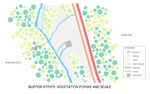 Buffer strips: vegetation form and scale
 -
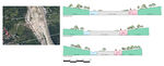 Cross sections
 -
 Characterization of land cover, referred to the vegetation dynamic
 -
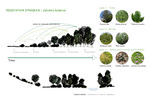 1st plant selection: some species from vegetation class of Prahova Valley


Projective drawings
Please add four projective sketches/drawings (or montages/schemes), of course with an emphasis on planting design/vegetation aspects. Every group member needs to contribute at least one drawing representing his/her individual ideas.
- Projective Drawings
-
 Projective basis and natural dynamics
 -
 Strategy for path structures and platforms (rooms)
 -
 Strategy for drainage (Integration of hydraulic dynamics)
 -
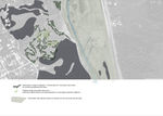 Strategy for planting (Landscape integration)


Design Synthesis
This project has a specific starting point: the modification of the landcover caused by the construction of several building, included in a wider hydraulic work.
This work caused the deforestation of land cover and we realized that this was a chance to create a new connection with river Prahova.
At first, we thought of combining two strategies:
- Create a network of pathways, rest areas and viewpoints.
- Restore the natural cover.
We are concerned about two issues(mainly risks):
- The risk of landslides in areas where vegetation had disappeared.
- River dynamics of the Prahova. We should be very cautious about actions that may occur in the riverbed.
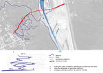
Finally, the decisions that we assumed in the master plan were:
1– To Build a network of paths and rest areas connected by trails and steps.
2– To connect the banks with a pedestrian bridge.
3– To solve the drainage by infiltration trenches.
4– To restore the plant cover.
5– To create new planting areas to connect the platforms.
Regarding to the planting, basically we worked with the species from the vegetation class, considering three layers: trees (like Betula pendula, Fagus sylvatica or Quercus robur), srhubs (like Crataegus monogyna, Euonymus latifolius, Prunus tenella or Rosa canina) and herbaceous (like Festuca sulcata, Fragaria viridis, Stipa capillata or Paeonia peregrina).
In each intervention or strategy (that concerns to the planting) predominates one, two or three of them:
- The three layers for restoring the vegetation cover.
- Trees and srhubs for path and steps.
- Srhubs and herbaceous to stabilize the riparian slope.
- Herbaceous for active area of aluvian plain.
- Srhubs and herbaceosus for the new planting areas to connect the platforms. In addition to the species of vegetation class, only in this case, non-native species are introduced. These species are well adapted and have a great ornamental value (some of them, Centaurea cyanus, Liatris spicata, Koeleria glauca, Silene vulgaris or Penstemon barbatus).
Concluding, we consider this work like an approach, a starting point, where the planting design is a tool to connect the projective work with nature.
- Design Synthesis Drawings
-
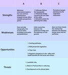 Swot analysis
 -
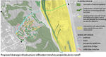 General plan
 -
 Skecthes related to the planting
 -
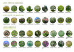 Plant selection with species of vegetation class (native) and well-adapted herbaceous with ornamental values


Summary of the collaborative process
In our case, the colaborative design process was a very interesting one with, hopefully fulfilling result. In the making of the design the water control and vegetation planting were the ideas that gave the site a sustenable design. The proposal potential was of an integrated sustenable design thanks to the influence of the different landcscape designs: spanish, chinese and romaininan. We took into consideration posible floods, possible landslide, and the posibility of the construction development in the aluvian plain. Speaking different languages is a problem everywhere, but in our case we managed to surpass that problem right from the beggining. A succesful design is only by colaborating with other professionals and get new ways of viewing the problem. By collaborating with different people with different culture and background not only we get more experince on working as a team, but new informations about how planting design is viewed and used in other countries.
Image Gallery
-
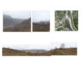 The Proposed Site. Landslide - Prahova Valley near Breaza
 -
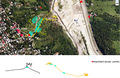 Key elements in understanding the site


References
*http://www.ibiol.ro/plant/Volume%2047/Rev.Roum.Biol.-Biol.Veget.,%202004,%20v.47,%20pp.41-56.pdf
*http://www.e-scoala.ro/geografie/flora_fauna_prahova.html
About categories: You can add more categories with this tag: "", add your categories