Collaborative Design Planting Design Working Group 26: Difference between revisions
| Line 99: | Line 99: | ||
Through our SWOT discussions we found: | '''Through our SWOT discussions we found: | ||
Strengths | |||
''Strengths''''' | |||
• We found the realism to be attractive, that is to say, we felt that our designs are not too farfetched, they are believable and effective in there simplicity. | • We found the realism to be attractive, that is to say, we felt that our designs are not too farfetched, they are believable and effective in there simplicity. | ||
• We had a focus on bringing people down to the river, improving planting, access, in order to improve how local people feel about the space. | • We had a focus on bringing people down to the river, improving planting, access, in order to improve how local people feel about the space. | ||
| Line 106: | Line 108: | ||
Weaknesses | '''''Weaknesses''''' | ||
• We have decided to highlight both the train line and the river, however this is a threat as some people would find this unsafe, therefor we need to have a plan for making these spaces safer. | • We have decided to highlight both the train line and the river, however this is a threat as some people would find this unsafe, therefor we need to have a plan for making these spaces safer. | ||
• Although community involvement would be a great thing, it would also mean quite heavy reliance on them keeping up maintenance. The site is large, and so more work would be required in to seeing planting selections that perhaps required less maintenance, at least in the more inaccessible areas. | • Although community involvement would be a great thing, it would also mean quite heavy reliance on them keeping up maintenance. The site is large, and so more work would be required in to seeing planting selections that perhaps required less maintenance, at least in the more inaccessible areas. | ||
| Line 112: | Line 115: | ||
Opportunities | '''''Opportunities''''' | ||
• We thought about the railway as an opportunity. None of our projective drawings suggested any improvements for safety. So we realized the possibility of making a permeable natural barrier made with climbing plants. This way there is a physical barrier but not a visual barrier, so the train passing is still part of the site. This reminded us slightly of the technical meet vegetated structure we saw in saw in Ferdinand Ludwig’s Seminar. We wanted to bring in this idea of ‘living Structures.’ | • We thought about the railway as an opportunity. None of our projective drawings suggested any improvements for safety. So we realized the possibility of making a permeable natural barrier made with climbing plants. This way there is a physical barrier but not a visual barrier, so the train passing is still part of the site. This reminded us slightly of the technical meet vegetated structure we saw in saw in Ferdinand Ludwig’s Seminar. We wanted to bring in this idea of ‘living Structures.’ | ||
• We realized one of the strongest opportunities was to intergrade the local community. We thought about how they could get involved if this project were to continue. Perhaps there could be allotments for them, perhaps they could get involved with maintenance and redevelopment of the site. | • We realized one of the strongest opportunities was to intergrade the local community. We thought about how they could get involved if this project were to continue. Perhaps there could be allotments for them, perhaps they could get involved with maintenance and redevelopment of the site. | ||
| Line 118: | Line 122: | ||
Threats | '''''Threats''''' | ||
• We have tried hard to intergrade all of our ideas, and so far the connected and complimented each other very well. However, we cannot be sure that local people would take to our ideas. For example, the might not like the idea to put in a more mixed assortment of vegetation, they might not like the idea of development at all, worrying that it will bring negative impacts. So, if it were possible to make this design a reality, one thing we would want to do is involve the local community. We would want our planting scheme to be immersive, that is to say that planting arrangements could be managed by groups of local people, and they would also have a say in designing the site. | • We have tried hard to intergrade all of our ideas, and so far the connected and complimented each other very well. However, we cannot be sure that local people would take to our ideas. For example, the might not like the idea to put in a more mixed assortment of vegetation, they might not like the idea of development at all, worrying that it will bring negative impacts. So, if it were possible to make this design a reality, one thing we would want to do is involve the local community. We would want our planting scheme to be immersive, that is to say that planting arrangements could be managed by groups of local people, and they would also have a say in designing the site. | ||
• The idea of having a walkway through the site works, however after discussion about flooding issues, we agreed that it was best to have a mown path, which can therefore change slightly year to year with changing of the river. | • The idea of having a walkway through the site works, however after discussion about flooding issues, we agreed that it was best to have a mown path, which can therefore change slightly year to year with changing of the river. | ||
• Another problem with the vegetated path, is that it could easily be wet, and too much of an uneven surface to walk on, we could solve this with under-bedded gravel, that the plants can grow through, in order to be mown in the right places to make a path. | • Another problem with the vegetated path, is that it could easily be wet, and too much of an uneven surface to walk on, we could solve this with under-bedded gravel, that the plants can grow through, in order to be mown in the right places to make a path. | ||
• Community spirit/lack of garden knowledge could be a problem. | • Community spirit/lack of garden knowledge could be a problem. | ||
== Design Synthesis == | == Design Synthesis == | ||
''Please analyse the individual approaches presented so far and evaluate their strengths and weaknesses (you may use the [http://en.wikipedia.org/wiki/SWOT_analysis SWOT]analysis model). Try to create a synthesis and represent it with a plan and some sketches. You can still use drawings/sketches.'' | ''Please analyse the individual approaches presented so far and evaluate their strengths and weaknesses (you may use the [http://en.wikipedia.org/wiki/SWOT_analysis SWOT]analysis model). Try to create a synthesis and represent it with a plan and some sketches. You can still use drawings/sketches.'' | ||
Revision as of 15:21, 31 January 2014
---> back to group page working group 26
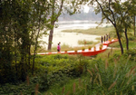
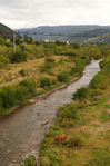
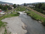
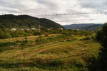
Târgului River, Câmpulung Muscel, Romania
Why this site?
Radu - I came across this site during a workshop I have participated to this summer, in Câmpulung Muscel, Romania. I related to the site almost instantly when I saw its potential of becoming a landmark of Câmpulung Muscel. The unicity it has, due to the man-made concrete slopes that frame the river with households on one margin and train rail on the other and the wildness of the plants that grow near the water has charmed me and I am very glad that my team-mates agreed to work on this site.
| Name | Târgului River | |
| Location | Câmpulung Muscel | |
| Country | Romania | |
| Authors | Rebecca Huggins, Sophia Meeres, Radu Mircea Giurgiu, John Lööf Green | |

| ||
| <googlemap version="0.9" lat="[45.273242]" lon="[25.049903]" type="map" zoom="18" width="300" height="250" selector="no" controls="small">
</googlemap> | ||
Landscape and/or urban context of your case
- Biogeography
Câmpulung Muscel is a city formed on both sides of the Târgului River. It's placed at the Sub-Carphatian Mountains. This region was early valued by it's inhabitant, the city growing to be an important econoical center. Here you can find forests, meadows, good rock for expoitation and good soil for growing vegetables. The river is crossing the city on 7.4 km long way, from North-Est to Suth -West.The city is placed at around 600m above sea level. You can find plants like Carpinus betulus, Populus termula, Betula verrucosa, Corylus avellana, Cornus mas, Craetegus monogyna, Rosa cannina, Sambucus nigra, Alnus glutinosa, Salix fragilis, Agrostis , Festuca rubra,
- Cultural features
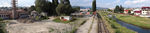
The city has a strong cultural background. It can be found alot of relics about the Romanian culture. The soroundings are also rich in culture and history from ancient ruins to beautifull arhitectural monuments. The city can be found in alot of writings from respected Romanian writers. In modern times, the city lost a little of it's charming, romantic features due to the lack of maintenance works. There is no strategy tourism-wie, so if people want to find the places that talk about the beautiful history and culture of the places, they will have difficultes in finding these places. The Târgului river is framed on both sides by houses and railroad. The animals from the households are living freely on the river shore. People are only passing by and they don't have activities related to the river. There is no pathway in the area, the vegetation grows freely keeping the people that are passing by on the path near the households.
- Overall character
Câmpulung Muscel has an impressive built and historical heritage, very diverse and nationally and internationally acknowledged. Approches on reabilitation and recovery of the sites has been given more attention in the last few years. The city has evolved due to it's rich heritage and resourses but sadly it's started to be forgotten in the last decades that lead to it's decay. The landscape, natural values, the tradition should support the future development.
History and dynamics Câmpulung Muscel was the first Capital of Romanian Country, from the will of the ruler Basarab the First. The sub-carpathian mountains zone where the city is placed gave great circumstances for the city to evolve and become an impotant economical city. Few decades ago, people used the river site as a recreational area. They were going to take baths in it, the place had a strong social character. The river changed the most when it was constructed a dam up the river..the building have grow in number closer to the river, he acces to the water was destroyed and the river's course has decreased. This was an important artificial intervention that chaned the river completly. The peoples link to the river was cut down and the wildness of the vegetation took its course.
- Present issues
There are some discussions in the town hall about development of the city, and the river is one of the subjects. The mayor spoke at a workshop in the summer of 2013 about redesigning the river site. Some ideas were about high waterfalls made by man to have more dynamicy, alot of terraces and decks so people can get closer to the river. They are not working with any Landscape Architects just with the town's Architect who says she had some courses of Landscape Architecture, who redesigned some of the parks from the city in a debatable fashion. In this context, the river is at the danger to be dramatically changed and lose its distinctive look and the potential of raising value of the site can be lost. Illustration: Map; sketches; short descriptive analyses
- Illustration: Map; sketches; short descriptive analyses
- widths="150px"
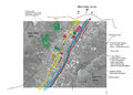
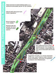
urban context
man vs nature


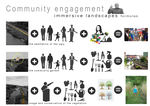
Our design objectives
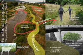
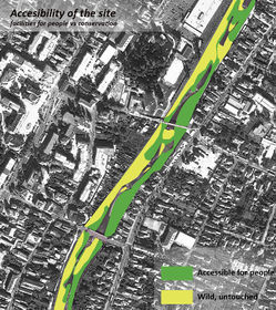
Our collaborative design will put forward best fit suggestions to help the municipality, proposing a development strategy based on a documentation on the urban context of the river. We want to give examples of good practices and ways of redesigning the river that are functional,non-aggressive and sustainable. From our first project discussions we realized the importance of involveing local people, right from the onset of the project. In order to bring back a sense of pride for the river, and get people spending time there again; essentially local people would make a brief for the space, telling us what is really needed. The objectives raised from this brief are likely to involve opening up access to the river, and creating a range of improved spaces using vegetation allowing for a variety of activities, children's play, swimming and bathing, animal watching etc We would also suggest implementations in stages, so that attention and interest in the river could be built up again, and perhaps to start work where the river meets the city center, and work outwards.
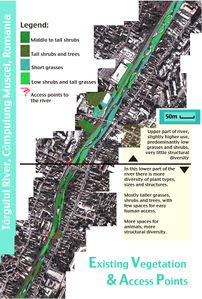
Analytical drawings
Please add four analytical sketches/drawings (or montages/schemes) of your case. Every group member needs to contribute at least one drawing.
- Analytical Drawings
urban context
Key Point! This area along the river has the potential to be a great meeting point. Ideas have been put forward to turn the old swimming baths in to an architectural school. The combined improvement of this space and the river corridor might being students in to the area, improving a green space that connects with the river and the train line. Trains along the line are slow and infrequent.

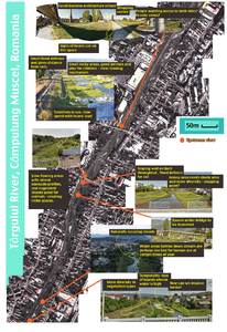


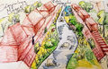
Projective drawings
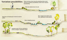
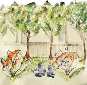
These projective drawings and sketches show our collective ideas for improvements to the river, sometimes there are sketches explaining structural hard landscape elements, however the emphasis in on planting design/vegetation aspects.
- Projective Drawings


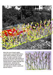
Case Studies
Group discussion lead to us thinking about case studies and instances of successfully designed landscapes that has a similar concept to ours.
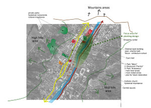
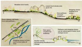
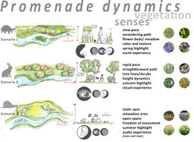
- Design Synthesis Drawings
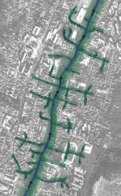
We found this landscape by Turnscape reflects our overall concept of design a planting scheme which gave people the opportunity to walk alongside the river, taking a journey. We have three ribbons, the river, and railway and a pathway amongst the vegetation. <http://www.archdaily.com/445661/red-ribbon-park-turenscape/>
This landscape uses a very bold element of the red "ribbon," running alongside the river. We would not need such a bold fixed element, but the concept is helpful. <http://www.archdaily.com/445661/red-ribbon-park-turenscape/>


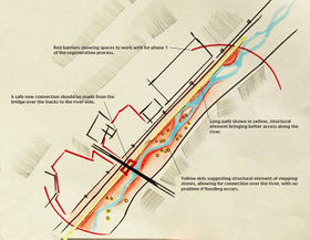
SWOT discussions
Overall we realized that although we liked our projective ideas, we found in a lot of ways they could be developed, in order to become more detailed and specific. The SWOT analysis made us change a lot of our ideas, and ultimately gave us new and stronger ideas for what we believed should happen to the site.
Through our SWOT discussions we found:
Strengths
• We found the realism to be attractive, that is to say, we felt that our designs are not too farfetched, they are believable and effective in there simplicity. • We had a focus on bringing people down to the river, improving planting, access, in order to improve how local people feel about the space. • Historically as the capital of Romania, there could be a lot of pride reinstated, and an improved water walkway could be just the way to do this! However the walkway could also be a threat!
Weaknesses
• We have decided to highlight both the train line and the river, however this is a threat as some people would find this unsafe, therefor we need to have a plan for making these spaces safer. • Although community involvement would be a great thing, it would also mean quite heavy reliance on them keeping up maintenance. The site is large, and so more work would be required in to seeing planting selections that perhaps required less maintenance, at least in the more inaccessible areas. • One weakness in all our ideas could be that they are vague; there is much room for development! We realized that there was only do far we could take this project considering time restraints. We questioned how necessary it would be in this situation to have a full planting plan, or to invite community members to build up the site gradually with guidance.
Opportunities
• We thought about the railway as an opportunity. None of our projective drawings suggested any improvements for safety. So we realized the possibility of making a permeable natural barrier made with climbing plants. This way there is a physical barrier but not a visual barrier, so the train passing is still part of the site. This reminded us slightly of the technical meet vegetated structure we saw in saw in Ferdinand Ludwig’s Seminar. We wanted to bring in this idea of ‘living Structures.’ • We realized one of the strongest opportunities was to intergrade the local community. We thought about how they could get involved if this project were to continue. Perhaps there could be allotments for them, perhaps they could get involved with maintenance and redevelopment of the site.
Threats
• We have tried hard to intergrade all of our ideas, and so far the connected and complimented each other very well. However, we cannot be sure that local people would take to our ideas. For example, the might not like the idea to put in a more mixed assortment of vegetation, they might not like the idea of development at all, worrying that it will bring negative impacts. So, if it were possible to make this design a reality, one thing we would want to do is involve the local community. We would want our planting scheme to be immersive, that is to say that planting arrangements could be managed by groups of local people, and they would also have a say in designing the site. • The idea of having a walkway through the site works, however after discussion about flooding issues, we agreed that it was best to have a mown path, which can therefore change slightly year to year with changing of the river. • Another problem with the vegetated path, is that it could easily be wet, and too much of an uneven surface to walk on, we could solve this with under-bedded gravel, that the plants can grow through, in order to be mown in the right places to make a path. • Community spirit/lack of garden knowledge could be a problem.
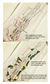
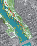
Design Synthesis
Please analyse the individual approaches presented so far and evaluate their strengths and weaknesses (you may use the SWOTanalysis model). Try to create a synthesis and represent it with a plan and some sketches. You can still use drawings/sketches.
- Design Synthesis Drawings
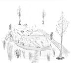
synthesis drawing 4


Summary of the collaborative process
Please reflect on your collaborative design process. Which potentials have you encountered? What was most difficult? What does collaborative design mean for you? (approx 150 words).
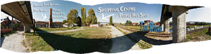
Image Gallery
You may add a series of images/photos in addition to the sketches/drawings
- Image Gallery
Targului River and future Architecture School
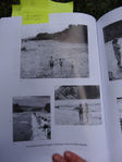
Photo of the river from the '60s
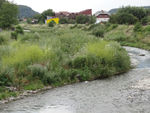
plants growing near water
animals on the river shore
the size of the river in some zones
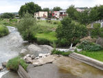
man made concrete slopes
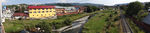
River Targului context
green areas near the river


References
* Please make sure that you give proper references of all external resources used.
* Do not use images of which you do not hold the copyright.
* Please add internet links to other resources if necessary.
About categories: You can add more categories with this tag: "", add your categories